Browse Listings in Map Types

Vue et perspective de la ville de Marseille et ses environs, prise du côté de la belle vue de la plaine St. Michel. Dediée à S. A. S. Mgr. le duc de Penthievre Grand Amiral de France. Par son très humble et très obéissant Serviteur Aulagnier.
Scarce large and spectacular panorama of the city and harbour of Marseille published in Paris in the middle of the 18th century. Engraved by Pierre Jacques Duret under th...
- $12000 / ≈ €11229
Place & Date: Paris, 1751

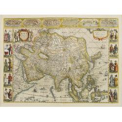
Carte d'Asie divisée en ses principaux Etats.
Uncommon and decorative "carte à figures" wall map, prepared by Clouet, with superb decoration including a wonderful rococo border with vignettes describing hi...
Place & Date: Paris, Mondhare, 1787
![[East coast of Africa, Arabia and west coast of India.]](/uploads/cache/04762-250x250.jpg)
[East coast of Africa, Arabia and west coast of India.]
Rare. Map of the east coast of Africa, Including Madagascar, the Arabian Peninsular, coast of Pakistan and west coast of India.Prepared by Joao Teixeira in 1649, this cha...
Place & Date: Paris, 1664-1696

L'Amérique divisée en ses principaux Etats Dressée d'après les Cartes de Mr. Bonne?
Rare, wall map of America in 2 sheets, after R. Bonne. With 3 inset maps of Hispaniola, Martinique and Hudson Bay. Beautiful title cartouche depicting a Native American l...
Place & Date: Paris, 1788
Asia recens summa cura delineata.
This is the rare early issue with decorative paneled borders. In upper border views and plans of Famagusta, Rhodos, Damascus, Jerusalem, Aden and Ormus. Originally engrav...
Place & Date: Amsterdam, 1632
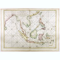
Carte réduite de l'archipel des Indes orientales avec les côtes du continent depuis le golfe de Manar jusqu'à Emoui à la Chine . . .
Important French chart of South East Asia with very good detail on Philippines. Latitude and longitude scales, compass rose and system of rhumb lines, soundings near coas...
Place & Date: Paris, 1745
Selling price: $3000
Sold in 2017

Pascaarte van een deel der Oost Zee, tusschen Bornholm ende der Memel, vertonende de ware gelegentheijt der Zeecusten van Pruijssen. . .
This very rare chart of the Northern Coast of Poland with Gdansk, appeared in the rare English edition of Willem Blaeu's 'Het Licht der Zeevaert', an atlas of sea charts ...
- $4000 / ≈ €3743
Place & Date: Amsterdam, 1608

The Wonderground Map of London.
A large and pictorially striking 'Wonderland' advertising poster on behalf of the London Underground, published in the late 1920s. The poster was very popular, and ran fo...
- $4000 / ≈ €3743
Place & Date: London, ca 1927
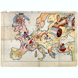
(Design for Hark ! Hark ! The dogs do bark.)
This very rare political caricature map of Europe depicts the continent at the outbreak of World War I, or as it was called at the time the Great War. The principal count...
- $3000 / ≈ €2807
Place & Date: London, ca. 1914
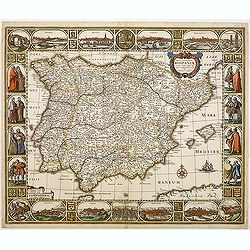
Nova et accurata Tabula Hispaniae. . .
Second state. This "carte à figures"- map of Spain and Portugal shows the geographical image introduced by Hessel Gerritsz's 1612 wall map of Spain. The map is...
Place & Date: Amsterdam, 1633