Browse Listings in Europe
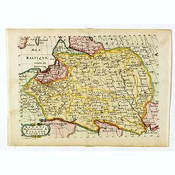
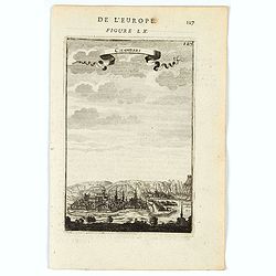
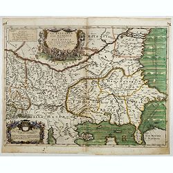
![Grande prefecture des Gavels. [de l'Europe / Figure LX] 135](/uploads/cache/38436-250x250.jpg)
Grande prefecture des Gavels. [de l'Europe / Figure LX] 135
A fine and uncommon early 17th-century map of Europe.From the French text edition of "Description d'Univers," 1683. by Allain Manneson Mallet (1630-1706), a wel...
- $30 / ≈ €26
Date: Paris, 1683
![France en general. [de l'Europe / Figure LXVII] 147](/uploads/cache/38437-250x250.jpg)
France en general. [de l'Europe / Figure LXVII] 147
A fine and uncommon early 17th century map of France.From the French text edition of "Description d'Univers", 1683. by Allain Manneson Mallet (1630-1706), a wel...
- $30 / ≈ €26
Date: Paris, 1683
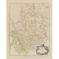
Estats de la Couronne de Pologne.
Map of Poland prepared by N.Sanson and published by F. Halma.Published in an Dutch edition of the small Sanson atlas L'Europe Dediée a Monseigneur . . . Le Tellier Secre...
Date: Amsterdam, Utrecht, 1683
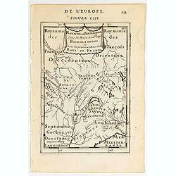
Royaume des… Royaume de Bourgogne sous la race des rois Bourguigons.
Map of Bourgogne region.Title in curtain draped at topFrom the original 1683 text edition of "Description d'Univers. . ." by Allain Manesson Mallet (1630-1706),...
Date: Paris, 1683
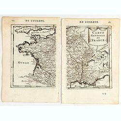
Carte generale de France.
A two-page map of France.Title in curtain draped at top. French text on verso.From the original 1683 text edition of "Description d'Univers. . ." by Allain Mane...
Date: Paris, 1683
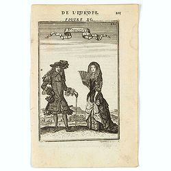
François.
A charming engraving of a French couple in 17th-century dress.Title in a curtain draped at top. French text on verso.From the original 1683 text edition of "Descript...
Date: Paris, 1683
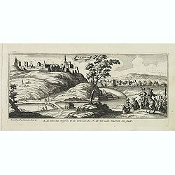
Chamberi.
A charming view of Chambery. Title in a curtain draped at top. French text on verso.From the original 1683 text edition of "Description d'Univers. . ." by Allai...
Date: Paris, 1683
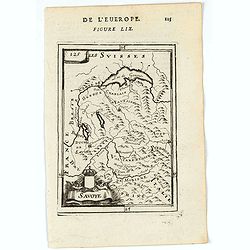
Savoye.
A charming map of Savoy. Title in a curtain draped at top. French text on verso.From the original 1683 text edition of "Description d'Univers. . ." by Allain Ma...
Date: Paris, 1683
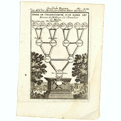
Arbre de Consanguinite Pour Faire Les Preuves de Noblesse de Chevalier de Malte.
An attractive piece that loosely translates to: Tree of Consanguinity To prove of Nobility of Knight of Malta. From Mallet's monumental Description de l' Univers, first p...
- $80 / ≈ €70
Date: Paris, 1683
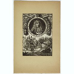
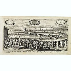
D. Gregoire Caraffe G. M. de Malte. M.C.D.LXXXI.
Portrait of Gregorio Carafa (1615 - 1690), 62nd Prince and Grand Master of the Order of Saint John (Knights of Malta) 1680 until his death in 1690.The sea battle undernea...
Date: Paris, Denys Thierry, 1683
![[Roi de France - King of France]](/uploads/cache/46496-250x250.jpg)
[Roi de France - King of France]
A portrait of Louis XIV King of France.French text on verso.From the original 1683 text edition of "Description d'Univers. . ." by Allain Manesson Mallet (1630-...
Date: Paris, 1683
![De l'Europe. [ Figure LXXXV].](/uploads/cache/38452-250x250.jpg)
De l'Europe. [ Figure LXXXV].
Decorative engraving showing "Ludovicus Magnus" or Louis XIV King of France, Coin Portrait.From the French text edition of "Description d'Univers", 16...
- $50 / ≈ €44
Date: Paris, 1683
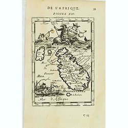
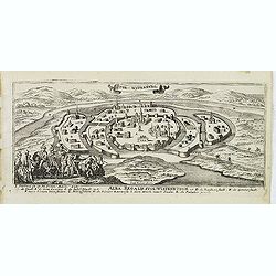
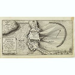
Isle de Malthe.
A charming late 17th century French map of Malta and Gozo with a large pictorial cartouche depicting Neptune and a mermaid, a nautical sailing ship scene across the botto...
- $250 / ≈ €218
Date: Paris, 1683
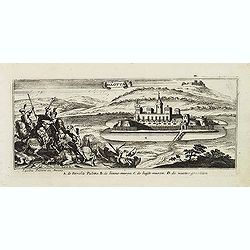
Malte.
A charming late 17th century French plan of La Valletta. With a ribbon style title cartouche and a nautical sailing ship scene across the top.By Allain Manneson Mallet (1...
- $225 / ≈ €197
Date: Paris, 1683
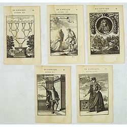
Set of 5 Malta related copper engravings.
Set of 5 Malta-related copper engravings from the French edition of the "Description De L'Univers" by Allain Manesson Mallet. French edition, 1683..By Allain Ma...
- $200 / ≈ €175
Date: Paris, 1683
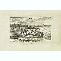
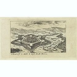
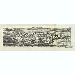
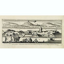
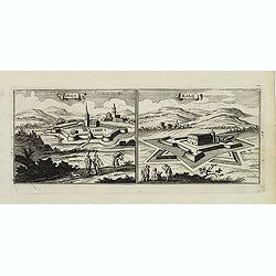
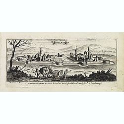
Sissek.
Panoramic view of Sisak in Sisak in central Croatia. Published in "Der Donau-Strand Mit allen seinen Ein- und Zuflüssen. . .". Published by Jacob Sandrart.
- $75 / ≈ €66
Date: Nuremberg, Jacob Sandrart, 1684
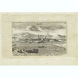
Rab. / Leopoldina. / Der Grosse und wunderbare Comet. . .
On recto panoramic view of Raab or Gyor, the Hungarian town on the Danube. On verso a plan of Leopoldina and a view of comet. Published in "Der Donau-Strand Mit alle...
- $90 / ≈ €79
Date: Nuremberg, Jacob Sandrart, 1684
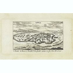
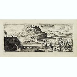
Gyula.
Panoramic view of Gyula in Békés County, Hungary. The town is best known for its Medieval castle and thermal bath. Published in "Der Donau-Strand Mit allen seinen ...
- $75 / ≈ €66
Date: Nuremberg, Jacob Sandrart, 1684
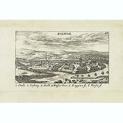
Zolnok.
Panoramic view of Szolnok (solnok) is the county seat of Jász-Nagykun-Szolnok county in central Hungary. Its location on the banks of the Tisza river, at the heart of th...
- $75 / ≈ €66
Date: Nuremberg, Jacob Sandrart, 1684
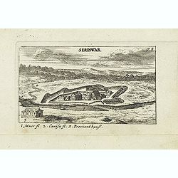
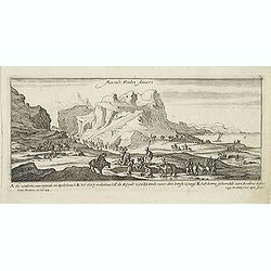
Serinwar. (Zrínyi vár)
Panoramic view of Zrínyi vár in Hungary. Published in "Der Donau-Strand Mit allen seinen Ein- und Zuflüssen. . .". Published by Jacob Sandrart.
- $90 / ≈ €79
Date: Nuremberg, Jacob Sandrart, 1684
Neuhäusl. (Nové Zámky)
Panoramic view of Nové Zámky, in southwestern Slovakia.Published in "Der Donau-Strand Mit allen seinen Ein- und Zuflüssen. . .". Published by Jacob Sandrart.
- $75 / ≈ €66
Date: Nuremberg, Jacob Sandrart, 1684
![Weitzen [Vác / Waitzen]](/uploads/cache/30817-250x250.jpg)
Weitzen [Vác / Waitzen]
Panoramic view of Vác / Waitzen with the Donau in the foreground Published in "Der Donau-Strand Mit allen seinen Ein- und Zuflüssen. . .". Published by Jacob ...
- $90 / ≈ €79
Date: Nuremberg, Jacob Sandrart, 1684
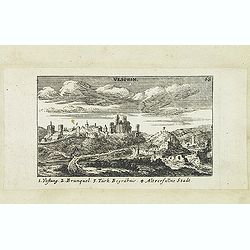
Vesprin.
Panoramic view of Veszprém is one of the oldest urban areas in Hungary, and a city with county rights. It lies approximately 15 km north of the Lake Balaton. Published i...
- $90 / ≈ €79
Date: Nuremberg, Jacob Sandrart, 1684
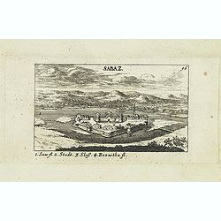
Sabaz. (Sabac)
View of Šabac in western Serbia, along the Sava river.Published in "Der Donau-Strand Mit allen seinen Ein- und Zuflüssen. . .". Published by Jacob Sandrart.
- $75 / ≈ €66
Date: Nuremberg, Jacob Sandrart, 1684
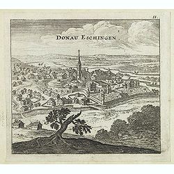
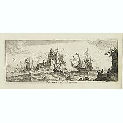
Donau Eschingen. / Der donaü stränd.
Two views pasted on recto and verso of a larger sheet of paper. On recto panoramic view of Donaueschingen a German town in the Black Forest.On verso a map of the Danube a...
- $75 / ≈ €66
Date: Nuremberg, Jacob Sandrart, 1684
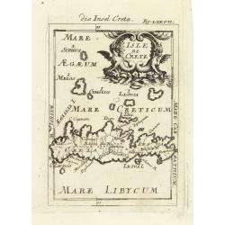
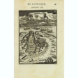
Isle de Crete.
A charming late 17th century map of the Island of Crete. By Allain Manneson Mallet (1630-1706), a well traveled military engineer and geographer who worked in 17th centur...
Date: Frankfurt, 1684
![Erla [Eger]](/uploads/cache/30834-250x250.jpg)
Erla [Eger]
Panoramic view of Eger. Published in "Der Donau-Strand Mit allen seinen Ein- und Zuflüssen. . .". Published by Jacob Sandrart.
- $150 / ≈ €131
Date: Nuremberg, Jacob Sandrart, 1684
Stulweissenburg. (Székesfehérvár)
Panoramic view of Székesfehérvár. Published in "Der Donau-Strand Mit allen seinen Ein- und Zuflüssen. . .". Published by Jacob Sandrart.
- $100 / ≈ €87
Date: Nuremberg, Jacob Sandrart, 1684
S. Nicolaes.
Beautifully etched by Gasper Bouttats (1640-1695) of Szent-Nicolas (Madarsko). Published by Jacques Peeters.
- $150 / ≈ €131
Date: Antwerp, c. 1684
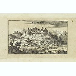
S. Martinsberg.
Panoramic view of S. Martinsberg. Published in "Der Donau-Strand Mit allen seinen Ein- und Zuflüssen. . .". Published by Jacob Sandrart.
- $100 / ≈ €87
Date: Nuremberg, Jacob Sandrart, 1684
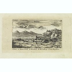
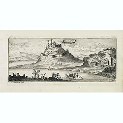
Dotis.
Panoramic view of Dotis (Tata). Published in "Der Donau-Strand Mit allen seinen Ein- und Zuflüssen. . .". Published by Jacob Sandrart.
- $150 / ≈ €131
Date: Nuremberg, Jacob Sandrart, 1684
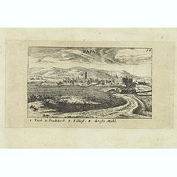
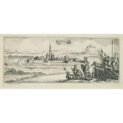
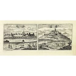
Papa.
Panoramic view of historical city Papa. Published in "Der Donau-Strand Mit allen seinen Ein- und Zuflüssen. . .". Published by Jacob Sandrart.
- $100 / ≈ €87
Date: Nuremberg, Jacob Sandrart, 1684
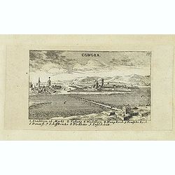
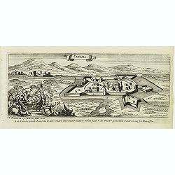
Comora.
Panoramic view of Comora. Published in "Der Donau-Strand Mit allen seinen Ein- und Zuflüssen. . .". Published by Jacob Sandrart.
- $100 / ≈ €87
Date: Nuremberg, Jacob Sandrart, 1684
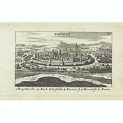
Caschav.
Panoramic view of Caschav (Cassovie). Published in "Der Donau-Strand Mit allen seinen Ein- und Zuflüssen. . .". Published by Jacob Sandrart.
- $100 / ≈ €87
Date: Nuremberg, Jacob Sandrart, 1684
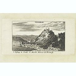
Vicegrad.
Panoramic view of Vicegrad. Published in "Der Donau-Strand Mit allen seinen Ein- und Zuflüssen. . .". Published by Jacob Sandrart.
- $100 / ≈ €87
Date: Nuremberg, Jacob Sandrart, 1684
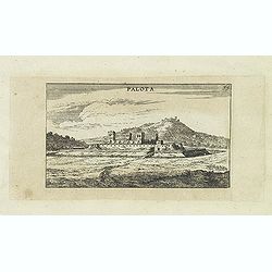
Palota.
Panoramic view of Palota in the Medzilaborce District in the Prešov Region of far north-eastern Slovakia. Published in "Der Donau-Strand Mit allen seinen Ein- und Z...
- $150 / ≈ €131
Date: Nuremberg, Jacob Sandrart, 1684
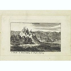
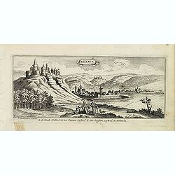
Filleck.
Panoramic view of Filleck (Fuleck, Filakovo). Published in "Der Donau-Strand Mit allen seinen Ein- und Zuflüssen. . .". Published by Jacob Sandrart.
- $150 / ≈ €131
Date: Nuremberg, Jacob Sandrart, 1684
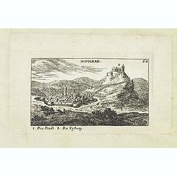
Novigrad.
Panoramic view of Nógrád in northern Hungary. Published in "Der Donau-Strand Mit allen seinen Ein- und Zuflüssen. . .". Published by Jacob Sandrart.
- $150 / ≈ €131
Date: Nuremberg, Jacob Sandrart, 1684
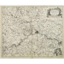
Comitatus Namurci Emendata Delineatio, Nuperrimè in lucem edita, per Nicolaum Visscher.
Detailed engraved map of the province of Namur (Namen), showing cities including Charleroi and Dinant., towns, rivers and lakes. Decorative cartouche with putti. Explanat...
Date: Amsterdam, 1684
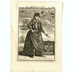
GM de Malte. Der Grossmeister von Malta Fig. XVIII.
Charming late 17th century engraving of grand master of Malta.By Allain Manneson Mallet (1630-1706), a well traveled military engineer and geographer who worked in 17th c...
- $120 / ≈ €105
Date: Frankfurt, 1685
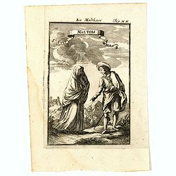
Maltois. Ein Maltheser Fig. XX.
Charming late 17th century engraving of a couple in local dress from Malta.By Allain Manneson Mallet (1630-1706), a well traveled military engineer and geographer who wor...
- $120 / ≈ €105
Date: Frankfurt, 1685

Zemblien.
Engraving presenting inhabitants of Nova Zembla from his monumental work "Description de L'Univers."
Date: Paris, 1685
![Ancien Cheva.er de Malte Ein Alter Malthese Ritter Fig: XVI [Together with] D. Gregoire Caraffe G.M. de Malte MDCLXXXI.](/uploads/cache/35860-250x250.jpg)
Ancien Cheva.er de Malte Ein Alter Malthese Ritter Fig: XVI [Together with] D. Gregoire Caraffe G.M. de Malte MDCLXXXI.
Two charming late 17th century engravings of an Knight of Malta and an round portrait of Gregoire Carafa.The copper plate seems during the printing process not well clean...
- $120 / ≈ €105
Date: Frankfurt, 1685
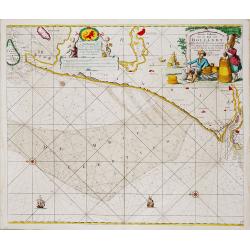
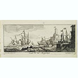
Nieuwe Paskaert van de Kust van HOLLANDT - Tussen Texel en de Maes.
Nieuwe Paskaert van de Kust van Hollandt Tussen Texel en de Maes. A very attractive sea chart off the coast of Holland by Johannes van Keulen with a pair of decorative c...
- $500 / ≈ €437
Date: Amsterdam, ca 1685
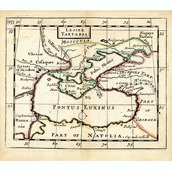
Lesser Tartaria.
A late seventeenth-century English map of the Crimea and southern Ukraine, with the whole of the Black Sea and its shores. A scarce little map utilized in various of the ...
- $300 / ≈ €262
Date: London, 1685
Malte Die Stadt Malta Fig: XV.
A charming late 17th century birds-eye view of Valletta and its fortifications from the southeast with battle ships in the sea. Title scroll in the sky.The copper plate s...
- $250 / ≈ €218
Date: Franckfurt, 1685
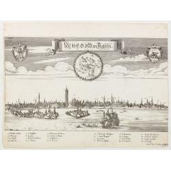
Venedig in Italien.
View of Venice with a numbered key 1-24. Lower right below the legend " Iohan Philip Steüdner ex Augusta". From "Theatrum Adriaticum, oder Schau-Platz de�...
Date: Augsburg, 1685
Isle de Malthe. Die Insul Maltha Fig: XIV.
A charming late 17th century map of Malta and Gozo with a large pictorial cartouche depicting Neptune and a merman, a nautical sailing ship scene across the bottom.The co...
- $250 / ≈ €218
Date: Frankfurt, 1685
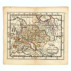
Moscovia or Russia
A rare late seventeenth-century English map of Russia and the Crimea and southern Ukraine, with the northern coast of the Black Sea and its shores. A scarce little map ut...
- $300 / ≈ €262
Date: London, 1685
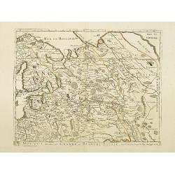
Moscovie dite autrement Grande et Blanche Russie.
Uncommon map of the Russia, including Finland, here with the date 1686.
Date: Paris, 1686
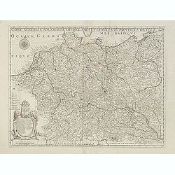
Carte générale d'Alemagne divisée par les cercles ou provinces d'icelle.
Rare and detailed map of Germany, Poland and Austria, engraved by H. le Roy in 1643 or 1666 for Jacques L'Agniet. Published by François Jollain (ca. 1641 – 18 April 17...
- $450 / ≈ €393
Date: Paris, 1689
La Prussia Divisa in Reale Che Appartiene al Ré Di Polonia et in Ducale Che Spetta all'Elettore Di Brandeburgo. Da Giacomo Cantelli Da ...
In the upper left-hand corner a large title cartouche with a dedication to Cardinal Denhoff. The map is dated 1689.The cartographer was Giacomo Cantelli (1643-1695) who w...
- $1000 / ≈ €874
Date: Rome, 1689
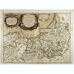
La Bulgaria ela Romania con Parte di Marcedonia. . .
Scarce map of the region along the Danube River and to the south. Extends to include part of the Sea of Azov and the northern extreme of the Aegean Sea. Elaborate militar...
- $600 / ≈ €524
Date: Rome, 1689
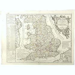
Le Royaume d'Angleterre.
An attractive map centered on England, Wales and the southern part of Scotland. The very decorative cartouche includes a dedication to Jacques II Roy d'Angleterre, d'Esco...
- $650 / ≈ €568
Date: Paris, 1689
Tockay. (Tokaj)
Magnificent bird's eye- of Tokaj. Etched by Gaspar Bouttats (1640-1695).The Antwerp based publisher Jacques Peeters published ca. 1690 a series of prints related to the H...
- $150 / ≈ €131
Date: Antwerp, c.1690
Guyla.
Magnificent bird's eye- of Gyula. Etched by Gaspar Bouttats (1640-1695).The Antwerp based publisher Jacques Peeters published ca. 1690 a series of prints related to the H...
- $125 / ≈ €109
Date: Antwerp, c.1690
Esseker brugh.
Fine print of the Esseker bridge in Osijek. Etched by Gaspar Bouttats (1640-1695).The Antwerp based publisher Jacques Peeters published ca. 1690 a series of prints relate...
- $125 / ≈ €109
Date: Antwerp, c.1690
Stoe-Wysenburg.
Magnificent bird's eye- of Szekesfehervar. Etched by Gaspar Bouttats (1640-1695).The Antwerp based publisher Jacques Peeters published ca. 1690 a series of prints related...
- $125 / ≈ €109
Date: Antwerp, c.1690
Vesprin.
Magnificent bird's eye- of Veszprem. Etched by Gaspar Bouttats (1640-1695).The Antwerp based publisher Jacques Peeters published ca. 1690 a series of prints related to th...
- $125 / ≈ €109
Date: Antwerp, c.1690
Palotta.
Magnificent bird's eye- of Varpalota. Etched by Gaspar Bouttats (1640-1695).The Antwerp based publisher Jacques Peeters published ca. 1690 a series of prints related to t...
Date: Antwerp, c.1690
Schombock.
Magnificent bird's eye- of Zsambek. Etched by Gaspar Bouttats (1640-1695).The Antwerp based publisher Jacques Peeters published ca. 1690 a series of prints related to the...
- $75 / ≈ €66
Date: Antwerp, c.1690
St Martinsbergh.
Magnificent bird's eye- of Pannonhalma (Szentmártonhegy). Etched by Gaspar Bouttats (1640-1695).The Antwerp based publisher Jacques Peeters published ca. 1690 a series o...
- $75 / ≈ €66
Date: Antwerp, c.1690
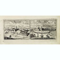
Nembti / Sengrot.
Magnificent bird's eye-town-views of Lenti and Zalaszengrot. Etched by Gaspar Bouttats (1640-1695).The Antwerp based publisher Jacques Peeters published ca. 1690 a series...
- $80 / ≈ €70
Date: Antwerp, c.1690
Canisia.
Magnificent bird's eye- of Nagykanizas. Etched by Gaspar Bouttats (1640-1695).The Antwerp based publisher Jacques Peeters published ca. 1690 a series of prints related to...
- $90 / ≈ €79
Date: Antwerp, c.1690
Piazza di Sta Maura esvoi Borghi Affediata dall Armi della. . .
Magnificent bird's eye- with the northern tip of the island of Santa Maura (today Lefkada). Situated very close to the mainland to which it is linked by a long strip of s...
Date: Antwerp, c.1690
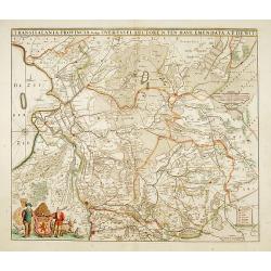
Transisalania provincia vulgo Over-Yssel auctore N.ten Have
Detailed map prepared by Nico ten Have.
Date: Amsterdam, 1690
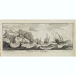
Canistro nel Arcipelago.
Magnificent view of Kanaestreo and its harbour front, decorated with ships and rowing boats in a rough sea. Engraved by Lucas Vostermans II, who was born in 1624, in the ...
- $100 / ≈ €87
Date: Antwerp, c.1690
Sixo / Kalo. (Szikszo and Nagycallo)
Magnificent bird's eye- of Szikszo and Nagycallo. Etched by Gaspar Bouttats (1640-1695).The Antwerp-based publisher Jacques Peeters published ca. 1690 a series of prints ...
- $75 / ≈ €66
Date: Antwerp, c.1690
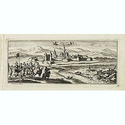
St:Servaes. (Szarvas)
Magnificent bird's eye- of Szarvas. Etched by Gaspar Bouttats (1640-1695).The Antwerp based publisher Jacques Peeters published ca. 1690 a series of prints related to the...
- $150 / ≈ €131
Date: Antwerp, c.1690
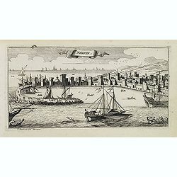
Modon. (Methoni)
Magnificent bird's eye-town-view of Methoni on Morée. Etched by Gaspar Bouttats (1640-1695).The Antwerp based publisher Jacques Peeters published ca. 1690 a series of pr...
- $150 / ≈ €131
Date: Antwerp, c.1690
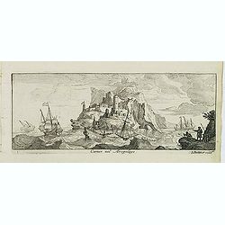
Pelaguse nel Arcipelago. (Pegalos)
Magnificent shipping scene offshore of Pelagos. Engraved by Lucas Vostermans II, who was born in 1624, in the same year when the family moved to England for six years. He...
- $125 / ≈ €109
Date: Antwerp, c.1690
Camos nel Arcipelago. (Samos Island)
Magnificent shipping scene offshore of the island of Samos. Engraved by Lucas Vostermans II, who was born in 1624, in the same year when the family moved to England for s...
- $100 / ≈ €87
Date: Antwerp, c.1690
Cercle de Westphalie.
Fine map of Westphalia. The address is much re-worked, now with the address Chez L'Autheur aux Galleries du Louvre , dated 1690.This edition carries the date 1690 and the...
- $100 / ≈ €87
Date: Paris 1690
Bartanico nel Arcipelago. (Bartanico)
Magnificent shipping scene offshore of Bartanico. Engraved by Lucas Vostermans II, who was born in 1624, in the same year when the family moved to England for six years. ...
- $125 / ≈ €109
Date: Antwerp, c.1690
Haftwan. (Hatvan)
Magnificent bird's eye- of Hatvan. Etched by Gaspar Bouttats (1640-1695).The Antwerp based publisher Jacques Peeters published ca. 1690 a series of prints related to the ...
- $100 / ≈ €87
Date: Antwerp, c.1690
Isola del Re Nel Mare di Guascogna . . .
A beautiful map showing Ile de Ré in Bretagne, located in the Bay of Biscay off the coast of France, from Vincenzo Coronelli's Corso Geografico Universale.Italian text o...
Date: Venice, 1690
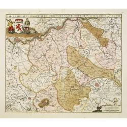
Tabula ducatus Limburch et comitatus Valckenburch. . .
The map describes the southern part of Limburg and reaches into Belgium (Liége, Verviers) and Germany. With two very decorative cartouches.
Date: Amsterdam, 1690
Rechnitz / Lewentz. (Breznica and Levice)
Magnificent bird's eye- of Breznica and Levice in Slovenia. Etched by Gaspar Bouttats (1640-1695).The Antwerp based publisher Jacques Peeters published ca. 1690 a series ...
- $150 / ≈ €131
Date: Antwerp, c.1690
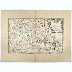
Partie Septentrionale de l'Evesché de Poictiers. Partie Septentrionale du Haut Poitou.
Rare map engraved by R. Michault and published "a Paris chez Greg. Mariette sur le quay de l'Horloge au dessus de la cour de Lamoignon". Dedicated to the Bishop...
Date: Paris, 1690
Villeck. (Filakovo)
Magnificent bird's eye- of Filakovo. Etched by Gaspar Bouttats (1640-1695).The Antwerp based publisher Jacques Peeters published ca. 1690 a series of prints related to th...
- $150 / ≈ €131
Date: Antwerp, c.1690
