Browse Listings in Europe
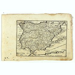
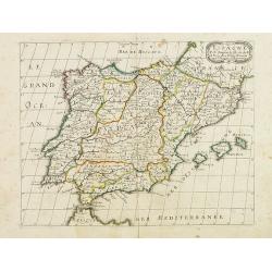
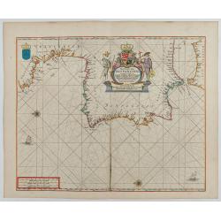
Espagne.
Rare map of Spain and Portugal, published by Jollain in 1667. Published in "Trésor Des Cartes Geographiques Des Principaux Estats de Lunivers".This atlas is ba...
- $200 / ≈ €175
Date: Paris, 1667
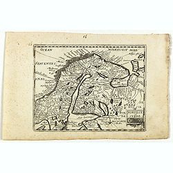
Norvege et Suede.
Rare map of Norway, Sweden and Finmark published by Jollain in 1667. Published in "Trésor Des Cartes Geographiques Des Principaux Estats de Lunivers".This atla...
- $250 / ≈ €218
Date: Paris, 1667
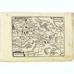
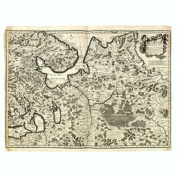
Russie.
Rare map of Russia, published by Jollain in 1667. Published in "Trésor Des Cartes Geographiques Des Principaux Estats de Lunivers".This atlas is based upon Boi...
- $250 / ≈ €218
Date: Paris, 1667
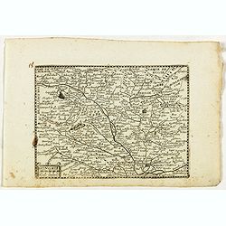
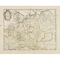
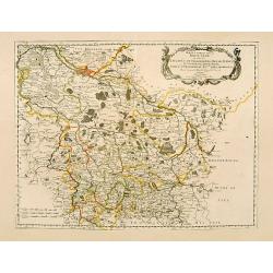
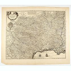
Hongrie.
Rare map of Hungary, published by Jollain in 1667. Published in "Trésor Des Cartes Geographiques Des Principaux Estats de Lunivers".This atlas is based upon Bo...
- $300 / ≈ €262
Date: Paris, 1667
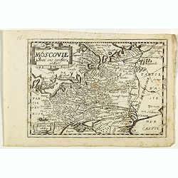
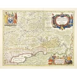
Moscovie avec ses confins.
Rare map of Russia, published by Jollain in 1667. Published in "Trésor Des Cartes Geographiques Des Principaux Estats de Lunivers".This atlas is based upon Boi...
- $450 / ≈ €393
Date: Paris, 1667
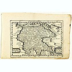
Moree jadis Peloponese.
Rare map of Peloponnese, published by Jollain in 1667. Published in "Trésor Des Cartes Geographiques Des Principaux Estats de Lunivers".This atlas is based upo...
- $300 / ≈ €262
Date: Paris, 1667
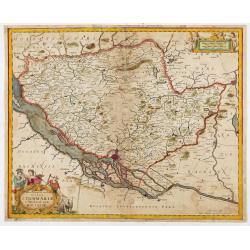
Russie Blanche ou Moscovie.
Map of the European part of Russia prepared by N.Sanson and published by Pierre Mariette.Published in an early edition of the small Sanson atlas L'Europe Dediée a Monsei...
Date: Paris, P. Mariette, 1667
Espagne. . .
Map of Spain and Portugal prepared by N.Sanson and published by Pierre Mariette.Published in an early edition of the small Sanson atlas L'Europe Dediée a Monseigneur . ....
Date: Paris, P. Mariette, 1667
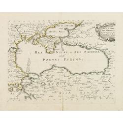
Mer Noire ou Mer Maievre, . . .
Map of the Black Sea prepared by N.Sanson and published by Pierre Mariette.Published in an early edition of the small Sanson atlas L'Europe Dediée a Monseigneur . . . Le...
Date: Paris, P. Mariette, 1667
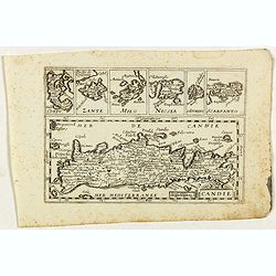
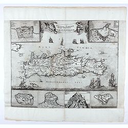
Candie.
Rare map of Crete with in top six small inset maps of Greek islands, published by Jollain in 1667. Published in "Trésor Des Cartes Geographiques Des Principaux Esta...
- $350 / ≈ €306
Date: Paris, 1667

Pascaart van de west cust van Engeland en Wales Van S. Davids Point tot de Moul van Dalway.
Rare Doncker's sea chart of the Irish Sea with the west Coast of England (Liverpool), the Island of Man and the western-most tip of Northern Ireland (Bangor) and Souther...
Date: Amsterdam, 1660-1668
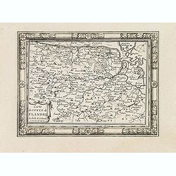
Carte du Comté de Flandre. . .
Decorative map of Flanders from Plans, et Profils des principales villes.. by Ch. De Beaulieu. Etched by mr. Romeijn de Hooghe.
- $80 / ≈ €70
Date: Paris, 1668
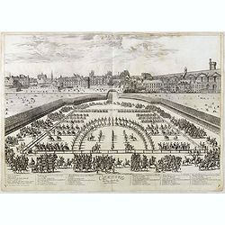
Comparse des Cinq Quadrilles dans l'Amphitheatre.
An early and intriguing engraving recording one of the most celebrated and spectacular festivals held at Paris by the young Louis XIV. The multi-day tournament took place...
Date: Paris, imprimerie royale, 1670
![Nova & exacta Chorographia Latii sive Territorii Romani iuxta veterem et novum situm parallela nomimu[m] comparatione elaborata.](/uploads/cache/44863-250x250.jpg)
Nova & exacta Chorographia Latii sive Territorii Romani iuxta veterem et novum situm parallela nomimu[m] comparatione elaborata.
Map of central Italy, centered on Rome from "Latium" by A. Kircher and designed by Innocenzo Mattei. The title cartouche in the lower right, small legend with 1...
Date: Amsterdam, 1671
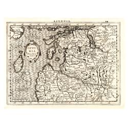
Livonia.
Finely engraved map of the Baltic states Estonia and Latvia filled with forests, rivers and lakes. French text on verso. Engraved by Petrus Kaerius for Janssonius' pocket...
Date: Amsterdam, Jan Cloppenburgh, 1673
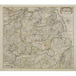
La Souabe.
Fine map of Swabia.This edition carries the date 1674 and the publishers address A PARIS chez l'Autheur aux Galleries du Louvre. Nicolas Sanson was to bring about the ris...
- $75 / ≈ €66
Date: Paris, 1674
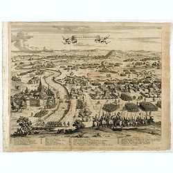
The siege of Lagny.
Very rare etching of the siege of Lagny-sur-Marne by the Duc of Parma. Etched by Johann Azelt (1654-1692). A similar print but with the number in the upper right corner i...
- $150 / ≈ €131
Date: Nuremberg, ca 1675
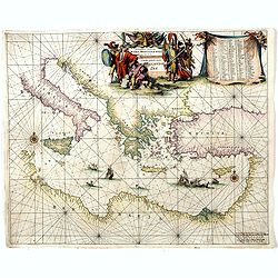
Orientalior districtus Maris Mediterranei.
Beautiful chart of the eastern part of the Mediterranean. Including Italy, the north coast of Africa and part of the Black Sea.The entire sheet is covered with rhumb line...
Date: Amsterdam, 1675
![[Lot of 8 maps and prints] Norvegiae Maritimae ab Elf-burgo ad Dronten / Pascaert van Noorwegen streckende van Elf-burg tot Dronten.](/uploads/cache/84130-250x250.jpg)
[Lot of 8 maps and prints] Norvegiae Maritimae ab Elf-burgo ad Dronten / Pascaert van Noorwegen streckende van Elf-burg tot Dronten.
Norvegiae Maritimae ab Elf-burgo ad Dronten / Pascaert van Noorwegen streckende van Elf-burg tot Dronten. Frederick de Wit's fine sea chart of southern Norway. An attr...
- $900 / ≈ €786
Date: Amsterdam, 1675

Paskaerte Vande Bocht van Vranckrijk Biscajen en Galissen
An eye-catching chart of Spain and France, including a large part of Brittany, including Isle de Reé , Isle Saint Martin ...Shows the gulf of the northeast Atlantic Ocea...
Date: Amsterdam, 1669-1676
Pas-Caart van Hispangien vertoonde de Custen van Granade…
An eye-catching chart of Spain and Portugal, including a large part of Brittany and the southwestern coast of France, including Isle de Reé , Isle Saint Martin ...Pieter...
Date: Amsterdam, 1669-1676
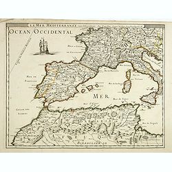
La mer mediterrannée, vers l'Occident. . .
Uncommon map of the western Mediterranean Sea, including France, Spain, Italy, Corsica Sardinia and North Africa. In upper left corner a large sailing vessel.
- $300 / ≈ €262
Date: Paris, 1676
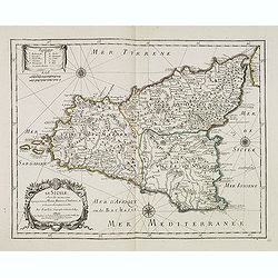
La Sicile, avec les anciens noms de presque toutes ses Places, Rivières, Chateaux &c. et diverses observations nouvelles . . .
Uncommon map of Sicily with fine title cartouche lower right . Original date of 1675 now altered to 1676.More about [+]
Date: Paris, 1676

A new mape of Ye XVII Provinces of Low Germanie.
Showing all 17 Provinces of the Netherlands before the split between Spain and the Protestant Provinces under the House of Orange.The map was first published. At the same...
Date: London, 1676
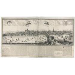
Londres 1678.
Extremely rare panoramic broad sheet panoramic town-view of London from Whitehall to the Tower, with underneath in letter press a description of the town's history. The o...
Date: Paris, 1677
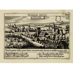
S. Iulius.
A very nice view of the castle of Saint Julius. On the foreground, several frogs are depicted. With a verse in two languages underneath the picture.The poet and topograph...
- $60 / ≈ €52
Date: Frankfurt, 1623-1678
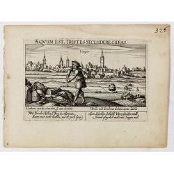
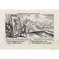
Aeqvum est, tristes secludere curas (Lianges.)
A very nice view of the city Lianges. With a verse in two languages underneath the picture.The poet and topographer from Comothau, Daniel Meisner (1585-1625), started his...
- $60 / ≈ €52
Date: Frankfurt, 1623-1678
![S. Victor in Franckr. [France].](/uploads/cache/13770-250x250.jpg)
S. Victor in Franckr. [France].
A very nice view of the church. On the foreground, a night watchman is depicted. With a verse in two languages underneath the picture.The poet and topographer from Comoth...
- $40 / ≈ €35
Date: Frankfurt, 1623-1678
S. Iulius.
A very nice view of the castle. On the foreground, several frogs are depicted with a verse in two languages underneath the picture.The poet and topographer from Comothau,...
- $60 / ≈ €52
Date: Frankfurt 1623-1678
![Cordelirs in Franckr. [France].](/uploads/cache/13812-250x250.jpg)
Cordelirs in Franckr. [France].
A panoramic view of the town of Cordeliers (probably imaginary) with in the center the church. In the foreground a man hunting a wolf. With a verse in two languages under...
- $50 / ≈ €44
Date: Frankfurt 1623-1678
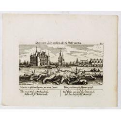
In einem Todt wollen alle zu Ritter werden.
A very nice view of a dead lion, surrounded by rabbits and in the background a French castle. With a verse in two languages underneath the picture. "In einem Todt, n...
- $70 / ≈ €61
Date: Frankfurt, 1623-1678
Villec.
A very nice view of Villec in Hungary (Fülek, Filakovo). In background a castle and in the foreground, a man examining a painting. With a verse in two languages undernea...
- $90 / ≈ €79
Date: Frankfurt, 1623-1678
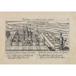
![S. Laurens in Franckr. [France].](/uploads/cache/13810-250x250.jpg)
S. Laurens in Franckr. [France].
A very nice view of the town of Saint Laurens in Alsace, with a church. On the foreground, an elephant and a rhinoceros are depicted. With a verse in two languages undern...
- $40 / ≈ €35
Date: Frankfurt, 1623-1678
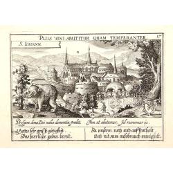
S. Iohann. Plus vini abutitur quam temperanter.
A very nice view of S.Johann Kloster with in the foreground, a wolf eating grapes. The Abbey of Saint John is an ancient Benedictine monastery in the Swiss municipality o...
- $70 / ≈ €61
Date: Frankfurt, 1623-1678
Vincennes - Viel hund Feind.des Hasen Todt.
A very nice picture representing Vincennes. With a verse in German and Latin. The German text reads : "Viel Hundt feind ja des Hasen Todr, Ihr viel bringn einen bald...
- $70 / ≈ €61
Date: Frankfurt, 1623-1678
![S. Victor in Franckr. [Paris].](/uploads/cache/13781-250x250.jpg)
S. Victor in Franckr. [Paris].
A very nice view of St. Victor church in Paris. In the foreground, a night watchman is depicted. With a verse in Latin and German underneath the picture. The German text ...
- $60 / ≈ €52
Date: Frankfurt, 1623-1678
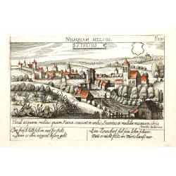
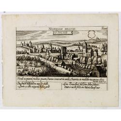
Nusquam Melius - S. Iulius.
A very nice view of the city Sint Juliaan in Belgium. With a verse in two languages underneath the picture.
- $30 / ≈ €26
Date: Frankfurt, 1623-1678
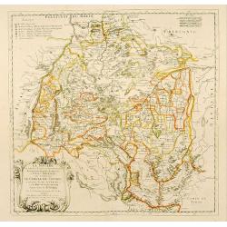
Stati della Corona di Polonia Divisa nella sue Principali Provincie e Palatinati da Guglielmo Sansone. . .
Rare map of Poland, Lithuania and the Ukraine. Copies of his first edition of 'Mercurio Geografico', published in 1674, do not contain a map of Poland. Only added in late...
- $1250 / ≈ €1092
Date: Rome, 1678
![Cordelirs in Franckr. [France].](/uploads/cache/13799-250x250.jpg)
Cordelirs in Franckr. [France].
A very nice view of the town of Cordeliers. On the foreground, a man hunting a wolf is depicted. With a verse in German and Latin underneath the picture.The poet and topo...
- $80 / ≈ €70
Date: Frankfurt, 1623-1678
![Hardales in Hispanien. [Spain].](/uploads/cache/13750-250x250.jpg)
Hardales in Hispanien. [Spain].
A very nice view of the city Hardales On the foreground, a man hunting a beaver. With a verse in Latin and German underneath the image.The poet and topographer from Comot...
- $60 / ≈ €52
Date: Frankfurt, 1623-1678
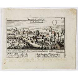
S. Iulius.
A very nice view of the town. In the foreground, a bridge with several frogs are depicted with a verse in two languages underneath the picture.The poet and topographer fr...
- $80 / ≈ €70
Date: Frankfurt, 1623-1678
![In einem Todt. . . [ Chateau Chenonceaux ]](/uploads/cache/13817-250x250.jpg)
In einem Todt. . . [ Chateau Chenonceaux ]
A very nice depiction of Chateau Chenonceaux near Tours, France within the foreground is a dead lion, surrounded by rabbits. With a verse in two languages underneath the ...
- $50 / ≈ €44
Date: Frankfurt, 1623-1678
![Cordelirs in Franckr. [France].](/uploads/cache/13736-250x250.jpg)
Cordelirs in Franckr. [France].
A very nice view of a monastery. With a verse in two languages underneath the picture.The poet and topographer from Comothau, Daniel Meisner (1585-1625), started his firs...
- $40 / ≈ €35
Date: Frankfurt, 1623-1678

Villec.
A very nice view the town of Villeck in Czechoslovakia. On the foreground, a man examining a painting is depicted. With a verse in two languages underneath the picture.Th...
- $75 / ≈ €66
Date: Frankfurt, 1623-1678
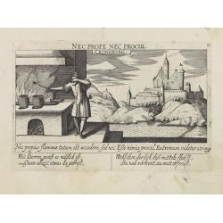
Croneburg.
A very nice picture representing the castle of Croneburg, of the German town of Kronenburg (now part of Dahlem). On the foreground, a man entertaining a fire is depicted....
- $75 / ≈ €66
Date: Frankfurt, 1623-1678
S. Laurens in Escurial.
A very nice picture representing the monastery of San Lorenzo del Escorial. On the foreground the god Jano, with two faces. With a verse in two languages underneath the p...
- $90 / ≈ €79
Date: Frankfurt 1623-1678
![Merla in Ob. Hessen. [Merlau]](/uploads/cache/13826-250x250.jpg)
Merla in Ob. Hessen. [Merlau]
A panoramic view of the castle and town of Merlau in Hessen. In the foreground, two men fighting each other are depicted. With a verse in two languages underneath the pic...
- $40 / ≈ €35
Date: Frankfurt, 1623-1678
![S. Victor in Franckr. [The Abbey of St. Victor near Paris.].](/uploads/cache/13769-250x250.jpg)
S. Victor in Franckr. [The Abbey of St. Victor near Paris.].
A very nice view of the Abbey of St. Victor near Paris. On the foreground, a night watchman is depicted. With a verse in two languages underneath the picture.The poet Dan...
- $60 / ≈ €52
Date: Frankfurt, 1623-1678
![Cordelirs in Franckr. [France].](/uploads/cache/13811-250x250.jpg)
Cordelirs in Franckr. [France].
A panoramic view of the town of Cordelirs (probably imaginary) with in center the church. On the foreground a man hunting a wolve. With a verse in two languages underneat...
- $35 / ≈ €31
Date: Frankfurt 1623-1678
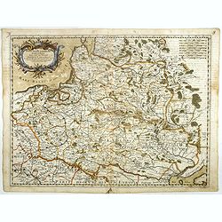
Haute Partie de la Basse Saxe..
Fine map of the northeastern part of Germany, including Hamburg and the rivers Wesel and Elbe. This edition carries the date 1679. Nicolas Sanson was to bring about th...
Date: Paris, 1679
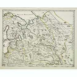
Moscovie dite autrement Grande et Blanche Russie.
Somewhat scarce map of the Russia centered on Moscow, including Finland.
- $450 / ≈ €393
Date: Paris, 1679
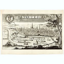
Treves (Trier)
Rare and decorative view of the city of Trier and the river Moselle in the foreground. In the upper left corner the coat of arms of France. The Jollain family was a famil...
Date: Paris, 1680
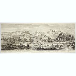
Veue de la ville, et fauxbourg de Salins…
Showing the town of Salins, a commune with salt works (Salines) in the Jura department in the region of Bourgogne-Franche-Comté in eastern France. With a key (1-15) in ...
- $700 / ≈ €611
Date: Paris, ca. 1680
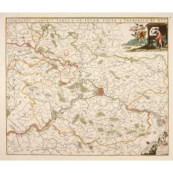
Comitatus Namurci Tabula in Lucem. . .
Centered on Namen, with decorative title cartouche upper right.
Date: Amsterdam, 1680
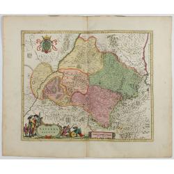
Navarra Regnum.
RARE : The signature by Willem Blaeu in the lower right corner has been erased. The copperplate was published by Frederick de WitDecorative map of the region which includ...
Date: Amsterdam, 1645-1680
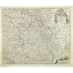
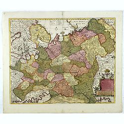
Regnum Bohemia.. Silesia.. Moravia, et Lusatia..
Detailed map of Czechoslovakia including the towns of Dresden, Prague, Breslau, etc. With fine title cartouche upper left, putti carrying the coats of arms of Bohemia, Mo...
- $400 / ≈ €349
Date: Amsterdam, 1680
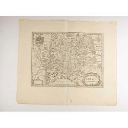
Erpach.
The town of Heidelberg is in most southern point on the map, including the rivers Rhine, Necker and Main.Rare issue published in Oxford. In 1680 the copper plates of Jans...
- $100 / ≈ €87
Date: Oxford, 1680

Belgium Foederatum emendate auctum et novissimé editum.
Fine detailed map of the area of the modern Netherlands less the southern part of Limburg. Title cartouche representing the commerce, the arts and the sciences. The Lion ...
Date: Amsterdam, 1680
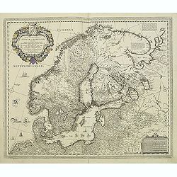
Tabula exactissima Regnorum Sueciae et Norvegiae..
Very fine and uncommon map of Scandinavia, after Andreas Buraeus, the father of Swedish cartography, whose map was compiled from original survey work. Dedicated to Gustav...
- $750 / ≈ €655
Date: Amsterdam, 1680
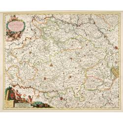
Ducatus Lutzenburgi Novissima et Accuratissima Delineatio.
West to the top. Very detailed and fine map of Luxembourg, including the towns of Namur, Liege, Trier and Metz.
Date: Amsterdam, 1680
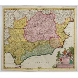
Regnorum Castellae, Novae, Andalujsae, Granadae, Valentae, et Murciae Accurata Tabula
Decorative map of Southern Spain, extending from Salamanca and Segovia in the North, to the Gulfs of Valentia, Alicante and Cartagena in the east, the Straits of Gibralta...
Date: Amsterdam, 1645-1680
Imperii Russici sive Moscoviae . . .
With the imprints of Pierre Mortier, Amsterdam map seller and Christopher Browne, indicating London publication about 1700. De Wit gives credit to Nicolas Witsen, Amsterd...
- $500 / ≈ €437
Date: Amsterdam, 1680
Nouvelle Carte geographique du Grand Royaume de Moscovie. . .
Scarce and detailed map centered on Moscow. Showing to the right the river Wolga and Azof in the south.
- $600 / ≈ €524
Date: Amsterdam, 1680
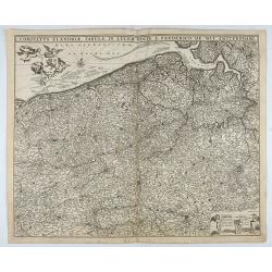
Comitatus Flandriae Tabula, In Lucem Edita A Frederico De Wit.
Double page map of Flanders, the whole Belgian region northwest of Brussels, confined by Antwerp, Brussels, valenciennes, Arras, St. Omer and the Channel. Title heading a...
Date: Amsterdam, 1680
Nova Totius Westphaliae descriptio.
Map of the northern provinces of Germany, including the Wad islands. West to the top. Including Bremen, Hildesheim, Kassel, Düsseldorf, etc. Also including the Dutch pro...
Date: Amsterdam, 1680
Insula Candia ejusque fortificatio.
An earlier and smaller version of De Wit's map of Candia. Richly engraved work, one of the most beautiful ever produced of Crete. There are insets of the fortifications a...
- $2500 / ≈ €2184
Date: Nuremberg, 1680

Mare Balticum. . . / Nieuwe Pascaert van de Oost Zee. . .
Decorative chart showing the Baltic sea, with a splendid cartouche of royal figures. A re-issue of the De Wit copper plates, now with many improvements.
- $2500 / ≈ €2184
Date: Amsterdam ca.1680
Gouvernement General de Languedoc. Divise en ses Vint Deux Diocesez.
A lovely late seventeenth century map of the central south French region of Languedoc, part of which borders the Mediterranean Sea by Dutch publisher and cartographer, Fr...
- $250 / ≈ €218
Date: Amsterdam, ca 1680

The Sea Coasts of France from Olone to Cape Machicaca in Biscay . . .
Detailed chart of Biscay Bay, showing the Coast of Brittany. The chart is oriented with north-east at the top and includes two large insets of the Loire River with Nantes...
Date: London, ca. 1680

The Sea Coast of France from Ushent to Olone.
Chart showing the Brittany coast from Ushent to Ollone, with Belle-Ile. In insets : Rade de Brest and Mouth of the Loire between St. Nazaire and Nantes.Originally engrave...
Date: London, ca. 1680
Tabula Geographica Novissima Ducatus Stormariae in Meridionali Parte Holsatiae.
A rare and beautiful map of the region of Germany around Hamburg. Fine detailed topography, including roads, fortifications, cities and villages. The title cartouche is s...
Date: Amsterdam, 1681
![Rumiliacum vulgo Rumilix. [Rumilly]](/uploads/cache/45513-250x250.jpg)
Rumiliacum vulgo Rumilix. [Rumilly]
Showing in great detail a bird's-eye view of the city of Rumilly in the Haute-Savoie, decorated with the coat of arms and a lettered key.From "Theatrum Sabaudiæ&quo...
- $150 / ≈ €131
Date: Amsterdam, 1682
![Abbaye d'Hautecombe. [Hautecombe Abbey]](/uploads/cache/45512-250x250.jpg)
Abbaye d'Hautecombe. [Hautecombe Abbey]
Showing in great detail a bird's-eye view of the Hautecombe Abbey, a former Cistercian monastery, later a Benedictine monastery, in Saint-Pierre-de-Curtille near Aix-les-...
- $150 / ≈ €131
Date: Amsterdam, 1682
Moscovia pars Australis.
Prepared by Isaac Massa, a Dutch map-maker who traveled to Russia, returning to Holland in 1609, bringing with him a large amount of original cartographic manuscript mate...
- $1000 / ≈ €874
Date: Oxford, 1682

Histoire de la République de Venise.
The History of the Republic of Venice Historia della Republica Veneta (dal 1613 al 1671), in Italian, which goes from 1613 to 1671, was translated by François Tallemant,...
- $1800 / ≈ €1572
Date: Cologne, Pierre Marteau, 1682
![Abbaye d'Hautecombe. [Hautecombe Abbey]](/uploads/cache/45509-250x250.jpg)
Abbaye d'Hautecombe. [Hautecombe Abbey]
Showing in great detail a bird's-eye view of the Hautecombe Abbey, a former Cistercian monastery, later a Benedictine monastery, in Saint-Pierre-de-Curtille near Aix-les-...
Date: Amsterdam, 1682
![Carte generale de France. [de l'Europe]](/uploads/cache/38442-250x250.jpg)
Carte generale de France. [de l'Europe]
A fine and uncommon early 17th century map of France printed from two copper plates. Engraved by Liébaux.From the French text edition of "Description d'Univers"...
- $80 / ≈ €70
Date: Paris, 1683
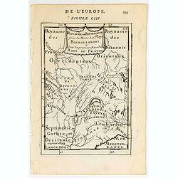
Royaume des… Royaume de Bourgogne sous la race des rois Bourguigons.
Map of Bourgogne region.Title in curtain draped at topFrom the original 1683 text edition of "Description d'Univers. . ." by Allain Manesson Mallet (1630-1706),...
Date: Paris, 1683
![Grande prefecture des Gavels. [de l'Europe / Figure LX] 135](/uploads/cache/38436-250x250.jpg)
Grande prefecture des Gavels. [de l'Europe / Figure LX] 135
A fine and uncommon early 17th-century map of Europe.From the French text edition of "Description d'Univers," 1683. by Allain Manneson Mallet (1630-1706), a wel...
- $30 / ≈ €26
Date: Paris, 1683
![France en general. [de l'Europe / Figure LXVII] 147](/uploads/cache/38437-250x250.jpg)
France en general. [de l'Europe / Figure LXVII] 147
A fine and uncommon early 17th century map of France.From the French text edition of "Description d'Univers", 1683. by Allain Manneson Mallet (1630-1706), a wel...
- $30 / ≈ €26
Date: Paris, 1683
