Browse Listings
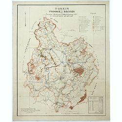
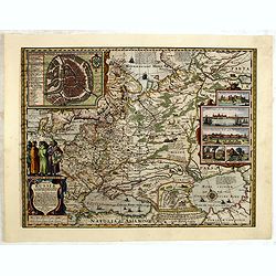
Tonkin Province de Bac-Kan Tournées faites par l'administrateur Blu au cours des années 1921-1922-1923.
Large scale manuscript map (1:200,000) centered on B?c K?n province in the northern region of Vietnam, north of the capital Hanoi.With a key in upper right corner, to the...
- $3000 / ≈ €2807
Place & Date: Hanoï, 1924

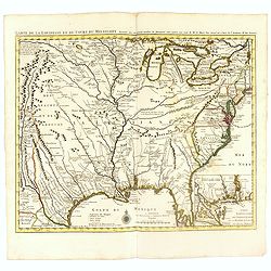
Amérique Septentrionale .. Les Etats Unis..
Very rare state: probably separately issued. Published the same year the Treaty of Paris was signed, this is one of the first maps to provide printed boundary lines for t...
- $3000 / ≈ €2807
Place & Date: Paris, 1786

Nieuwe Wassende Graade Zee Kaart over de Spaanse Zee Vant Kanaal tot 't Eyland Cuba in Westindia. . .
¤ Engraved by I.van Anse. A very representative example of a Dutch chart of the Atlantic, showing the north-east coast of America, the coasts of Africa and Europe and So...
Place & Date: Amsterdam, 1728

Almanach géographique ou petit atlas élémentaire composé de Cartes générales et particulières des différens Empires, Royaumes et Républiques de l'Europe. . .
Charming almanac with two engraved dedication and title page, portrait of Christian VII. Roy de Dannemarck et de Norvège.The map of Asia is of interest for the use of Ko...
- $3000 / ≈ €2807
Place & Date: Paris, 1770
![A Map of the United States and Canada, New-Scotland, New-Brunswick and New-Foundland ... [together with] A Map of the West-Indies and of the Mexican-Gulph...](/uploads/cache/39235-250x250.jpg)
A Map of the United States and Canada, New-Scotland, New-Brunswick and New-Foundland ... [together with] A Map of the West-Indies and of the Mexican-Gulph...
A Map of the United States and Canada, New-Scotland, New-Brunswick and New-Foundland / Carte des Etats Unis, avec Le Canada, la Nouvelle Ecosse, le Nouveau Brunswick &...
Place & Date: Paris, 1806
Atlas Geographicus portatilis XXIX mappis orbis habitabilis
Fine pocket atlas containing a world and celestial map, further maps of the four continents and of European countries. The map of America has a blank coastline north to C...
- $2750 / ≈ €2573
Place & Date: Augsburg 1762
![Monacum. [Munich Folio CCXXVI ]](/uploads/cache/14365-250x250.jpg)
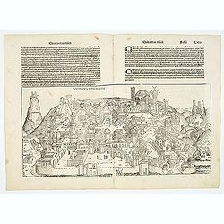
Monacum. [Munich Folio CCXXVI ]
A very fine representation of the city of Munich.Page from the richest illustrated Incunable, the famous: Nuremberg Chronicle, published the year that Columbus returned t...
- $2500 / ≈ €2339
Place & Date: Nuremberg, 12 July 1493

Carte de la Nouvelle France, ou se voit le cours des Grandes Rivieres de S. Laurens & de Mississipi..
Derived from de Fer's 1718 map, from west of the Mississippi it contains a mass of inland detail with notes and vignettes of the indigenous peoples and fauna of North Ame...
- $2700 / ≈ €2526
Place & Date: Amsterdam, 1720
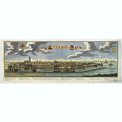
Ostende in Flandern.
Panoramic of Oostende. With a numbered key (1-11) in lower part. Text in German.Learn about the Ostend Trading Company or ‘Generale Keijserlijche Indische compagnie�...
- $2500 / ≈ €2339
Place & Date: Augsbourg, 1729
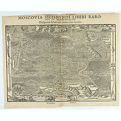
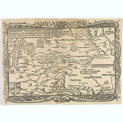
Moscovia Sigismundi Liberi Baronis In Herberstein, Neiperg et Gutehnag Anno M.D XLIX
First Modern Map of Russia. A rare and important cornerstone map for Russia collections.Sigismund von Herberstein made two visits to Russia. In 1517-18 he travelled as a ...
- $3000 / ≈ €2807
Place & Date: Vienna, 1549
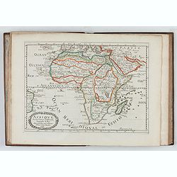
L'Affrique En Plusieurs Cartes Nouvelles, et exactes, &c.
Edition illustrated with 18 maps in original outline colors dated 1656. No date and title page and maps not numbered (according to Pastoureau 1 C, maps are numbered).Nico...
Place & Date: Paris, l'Auteur, after 1662

Eastern passage to China. sheet 1.
James Horsburgh early chart of the coasts of Java, Bali, Lombok, with part of Sulawesi, and Borneo. Insets of "Sketch of Bally Strait", Sketch of Lombock Strait...
- $2500 / ≈ €2339
Place & Date: London, 1824
Madrid Villa Capital Del Reyno D'Espana.. / Madrid ville capitale du Royaume d'Espagne . . .
A very decorative and scarce town view of Madrid, including a numbered key ( 1-17 ) in Spanish and French in the lower part. Published by Jacques Chéreau, (1688 - 1776)....
- $3000 / ≈ €2807
Place & Date: Paris, ca.1750
Schweidnitz. (Swidnica)
A spectacular panoramic view of Swidnica is a city in south-western Poland, with legends numbered from 1-19 in German. With the title in a banderol.After a design by Frie...
- $2500 / ≈ €2339
Place & Date: Augsburg, 1729
Naples, Ville de la Province de Labour, Archiépiscopale, et Capitale du Royaume de Naples.
A very decorative and extremely rare view of Naples, including a numbered (1-18) key in the lower part. Published by Jacques Chéreau, (1688 - 1776). Engraved by Aveline ...
- $3500 / ≈ €3275
Place & Date: Paris, ca.1750
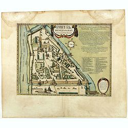
Kremlenagrad, Castellum urbis Moskvae . . .
Rare plan of the Kremlin, which appeared only in his Atlas Major. The map shows exceptional detail inside the heart of Moscow's inner walled fortress and the Kitai Gorod ...
- $2750 / ≈ €2573
Place & Date: Amsterdam, 1662
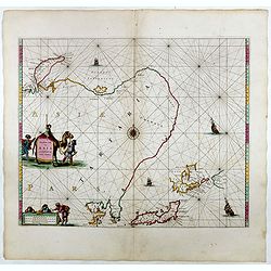
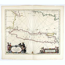
Noordoost Cust van Asia van Japan tot Nova Zemla.
An eye-catching chart of Hokkaido and the Islands to the North of Japan. Ships navigate the seas around the Siberian, Chinese and Japanese coasts extending as far west as...
- $2500 / ≈ €2339
Place & Date: Amsterdam, 1666
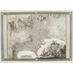
Planta della citta di Napoli come esifte nel prefeute Anno MDCCXC.
Stunning plan of Naples, prepared by Rizzi-Zannoni and engraved by Giuseppe Guerra from Naples. To the right and left a key to the important places of interest, among the...
- $2500 / ≈ €2339
Place & Date: Naples, 1790
Moscovia Sigismundi Liberi Baronis In Herberstein, Neiperg et Gutehnag Anno M.D XLIX
First Modern Map of Russia. A rare and important cornerstone map for any Russian collection.One of two maps of Russia compiled by Herberstein, who was ambassador from the...
Place & Date: Basle, 1556

Nova Virginiae tabula.
A fine example of Blaeu's map of Virginia and the Chesapeake region is based on the first state of Smith's map, 1612, and is slightly larger and more expertly engraved.Th...
Place & Date: Amsterdam, 1635/1660
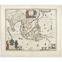
India quae Orientalis dicitur, et insulae adiacentes.
Extending from India to Japan and showing parts of Australia. It is indeed one of the first printed maps to show identifiable parts of Australia. It was not revised until...
- $2500 / ≈ €2339
Place & Date: Amsterdam, 1644
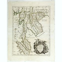
Penisola dell India di là dal Gange. . .
Giacomo Rossi's fine late 17th-century map of Malaysia, Thailand, Cambodia and part of Sumatra. Issued in Il Mercurio geografico In the lower right-hand corner a large ti...
- $2500 / ≈ €2339
Place & Date: Rome, 1683-1688
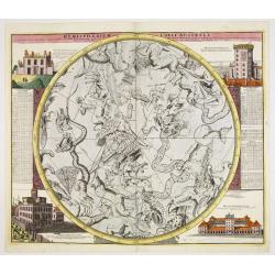
Hemisphaerium Coeli Australe in quo Fixarum. . .
Magnificent celestial chart drawn by the famous scientist Johann Gabriel Doppelmayr.Large circular charts of the southern hemisphere constellation, with decorative vignet...
- $1800 / ≈ €1684
Place & Date: Nuremberg, 1747
Insulae Iavae Cum parte insularum Borneo Sumatrae..
An elegant sea chart of the island of Java with parts of Sumatra, Borneo and Bali. The map includes only coastal detail and shows the Dutch capital in the East Indies at ...
Place & Date: Amsterdam, 1652
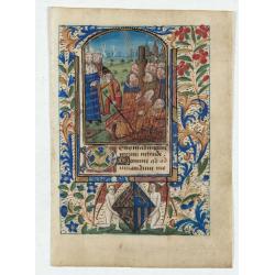
Miniature of Suffrages to the Saints.
A fantastic miniature (70 x 50 mm.) in an arched compartment showing the Suffrages to the Saints. Depiction of the (50) martyrs being burnt before King''s orders. The sty...
- $2500 / ≈ €2339
Place & Date: France, Bretagne or Normandy, c. 1480
Tabula Russiae.
One of the most decorative maps of Russia, based on the work of Fedor Borisovich. In an inset -130x170mm- a plan of the city of Moscow, in another inset -170x115mm- panor...
- $3000 / ≈ €2807
Place & Date: Amsterdam, 1656-1677
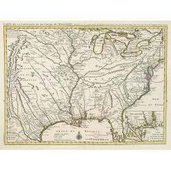
Carte de la Louisiane et du Cours du Mississipi Dressée sur un grand nombre de Memoires..
Covens & Mortier's issue of Delisle's influential map of the French possession of Louisiana. Updated to include New Orleans. When originally published in 1718, it was...
- $2400 / ≈ €2246
Place & Date: Amsterdam, c. 1745
La Flamboyante Colomne des Pays-Bas. Autrement dict les XVII Provinces. Chez Jacob Colom.
Rare atlas of the Low Countries, by Jacob Colom, in an early – first- French edition. The atlas was first printed in Dutch (1635) and than in 1636 in French, using the ...
- $3000 / ≈ €2807
Place & Date: Amsterdam, 1636

La parte orientale dell' antico.. messico con la Florida..
A splendid two-sheet map of Mexico, including California, Arizona, New Mexico, part of Texas, Baja California and Mexico (west part) and of the Southeast Part of the US, ...
Place & Date: Rome, Calcography, 1797-before 1839
Factorij der Nederlanders op Firato.. 1609-1641.
Bird's-eye view of Hirado, a trading post of the V.O.C. from 1609 until 1641.Von Siebold was born in Wurzburg, in Germany, and worked for the Dutch government as a doctor...
- $1500 / ≈ €1404
Place & Date: Leiden, 1832-1852
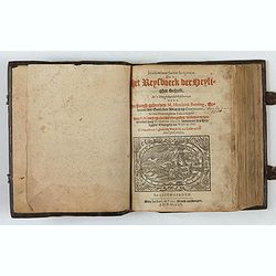
Itinerarium Sacrae Scripturae, dat is, Het Reysboeck der heyligher Schrift
This is a scarce 1648 Dutch edition of Büntings "Itinerarium Sacrae Scripturae" printed in Leeuwarden. The book includes 6 folding maps and 2 plates. The book ...
- $3000 / ≈ €2807
Place & Date: Leeuwarden, de Vries, Jan Jansz., 1648
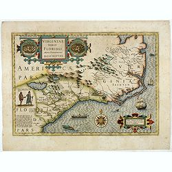
Virginiae item et Floridae. . .
Cummings describes it as one of the most beautifully executed maps ever made of the Southeast. In detail and in general conception it surpasses all earlier maps of the re...
- $2500 / ≈ €2339
Place & Date: Amsterdam, 1630
Carte de la Louisiane et du Cours du Mississipi Dressée sur un grand nombre de Memoires. . .
Covens & Mortier's issue of Delisle's influential map of the French possession of Louisiana. Updated to include New Orleans.When originally published in 1718, it was ...
Place & Date: Amsterdam, c. 1745
Selling price: $1400
Sold in 2010
Planisfero del Mondo Vecchio. . .
A decorative map of the Eastern hemisphere includes Abel Tasman's discoveries in Australia. The decorative borders include coordinates and descriptions of signs of the zo...
Place & Date: Venice, 1691
Selling price: $1800
Sold in 2015
Insulae Americanae in Oceanus Septentrionali cum Terris..
General map of the West Indies extending from Virginia to the mouth of the Orinoco, and destined to be copied in various shapes by many other publishers.Title cartouche t...
- $2500 / ≈ €2339
Place & Date: Amsterdam, 1644

Avantures du Sr. C. Le Beau, avocat en parlement ou Voyage curieux et nouveau parmi les Sauvages de l'Amérique Septentrionale. Dans lequel on trouvera une Description du Canada… Ouvrage enrichi d'une Carte et des figures necessaires.
A description of Huron, Iroquois, and Algonquin customs, written in charming style and based, the Author claims, on observations made on a trip to America in 1729." ...
- $2500 / ≈ €2339
Place & Date: Amsterdam, 1738

India Orientalis.
Published in Hondius' editions of the Mercator Atlas from 1606 onwards, showing the Indian subcontinent, the Malay Peninsula, Siam and Cambodia, China and the Philippines...
- $2200 / ≈ €2059
Place & Date: Amsterdam, 1630
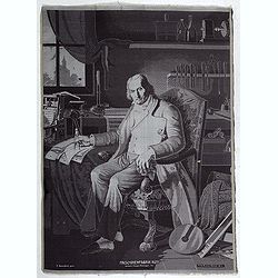
Maschinenfabrik Rüti, vormals Caspar Honegger tex.
Extremely rare woven silk portrait of Jean-Marie Jacquard drawn by Fritz Kaeser after the painting by C. Bonnefond, produced on the famous Honneger mechanical loom in Rü...
Place & Date: Zürich, Rüti, ca. 1847
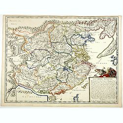
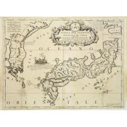
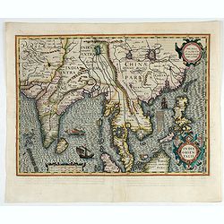
La Chine Royaume. . .
An important and attractive French map of the whole of China, the northern tip of the Philippines, with a strangely curved Korea and an under-sized Taiwan here called &qu...
- $2600 / ≈ €2433
Place & Date: Paris, 1656

Tartariae sive Magni Chami Imperium.
This is a very early depiction of the northern Pacific, with the first mapping of Northwest Coast of America and probably the first map to name California 'C. Califormio...
- $2500 / ≈ €2339
Place & Date: Antwerp, c. 1608-1612
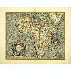
Africa ex magna orbis terre descriptione Gerardi Mercator. . .
A classic map of Africa. The map first appeared in Gerard Mercator’s Atlas sive Cosmographicae..., published posthumously in 1595. As stated in the title, this map is b...
- $2200 / ≈ €2059
Place & Date: Duisburg and then Amsterdam, (1595) 1609 or 1619
Mappa Aestivarum Insularum, alias Barmudas. . .
It shows the island divided into tribes and lots, and below the map itself appear the coats of arms of Bermuda and England and the names of the first proprietors and the ...
- $2000 / ≈ €1871
Place & Date: Amsterdam, 1645
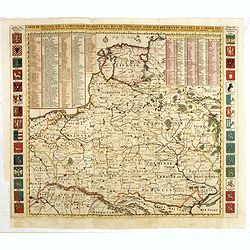
Carte De Pologne Avec La Chronologie Des Rois Et Des Ducs De Lithuanie, Ainsi Que Des Grands M. De L'Ordre Teutonique Les Evechez et Archeveches, et Les Armes Des Provinces . . .
Map of Poland with a key table to the towns, and 30 coats of arms on both sides, extending south the Black Sea. From Chatelain's monumental 7-volume "Atlas Historiqu...
- $1750 / ≈ €1638
Place & Date: Amsterdam, 1720
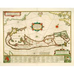
Mappa Aestivarum Insularum, alias Barmudas..
This magnificent map is based on the famous survey by John Norwood of the Bermuda Company in 1618. The map shows the division into the original Tribes and shows the vario...
- $2000 / ≈ €1871
Place & Date: Amsterdam, 1640
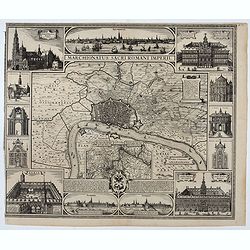
Marchionatus Sacri Romani Imperii.
Plan of the city of Antwerp in Belgium, by Claes Janszoon Visscher and first published by his son. The map is surrounded by 3 city views and 10 building vignettes and inc...
- $1750 / ≈ €1638
Place & Date: Amsterdam 1624
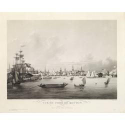
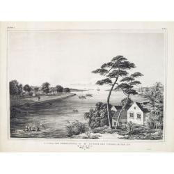
Vue du Port de Boston. View of the Port of Boston.
Superb aquatint of Boston harbor. Painted by L. Garneray and engraved by Himely. Published by Hocquart in Paris and Bailly Ward and Co. of New York.Second state with the...
- $2200 / ≈ €2059
Place & Date: Paris, ca. 1834

Nouveau théâtre de la guerre entre les Russes les turcs et les polonois confédérés.
A very rare separately published map of Crime region. With a large title cartouche lower left "Nouveau theâtre de la guerre entre les russes, les turcs et les polon...
- $2000 / ≈ €1871
Place & Date: Paris, 1769

Noordoost Cust van Asia van Japan tot Nova Zemla.
An eye-catching chart of Japan, Hokkaido and the Islands to the North of Japan. In the lower left Korea and part of northern China. Korea has three names mentioned: "...
- $2000 / ≈ €1871
Place & Date: Amsterdam, 1666
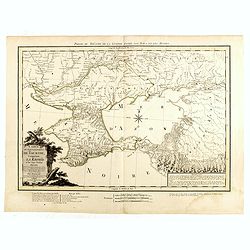
Carte du Gouvernement de Tauride, comprenant la Krimée et les pays voisins: dressée principalement d'après la carte faite sur les lieux pour le voyage de S.M. l'impératrice de Russie. . .
Rare map of southern Ukraine and the Crimea during the Second Russo-Turkish War (1787-92). Antique map of the Crimea during the Second Russo-Turkish War (1787-92), fought...
- $2500 / ≈ €2339
Place & Date: Paris, 1788
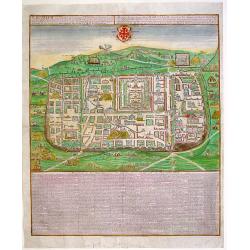
JERUSALEM, cum suburbiis..
Bird's eye perspectives town-plan of Jerusalem. Lower part of print an extensive numbered key (1-254) to principal buildings in town. Title in Latin and German. The print...
- $2250 / ≈ €2105
Place & Date: Augsburg, 1740
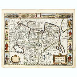
A newe mape of Tartary.
One of the most decorative maps of Tartary, known for its figured borders with costume figures, while above are vignettes of the cities of Astrakhan, Samarkand and Cambal...
- $2000 / ≈ €1871
Place & Date: London, Bassett & Chiswell, 1627-1676
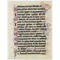
Illuminated leaf from a lithurgical Psalter.
Very fine illuminated leaf from a liturgical Psalter in Latin with the reading from the Vulgate Bible, Deuteronomy 32:16 - 32:27. Lines in a slightly irregular Gothic han...
Place & Date: Flanders, Rhineland, or possibly England, c. 1280
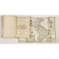
Introduction a la Geographie..
Second edition of this charming travel compendium illustrated with a fine world map in two hemispheres prepared by de l'Isle. California as an island. The hemispheres are...
- $2000 / ≈ €1871
Place & Date: Paris, 1717
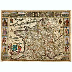
Gallia. Nova Galliae descriptio . . .
Very rare and early map of France with figures on three sides with views of cities, portraits (Henri IV and Marie de Medicis) and costumes. The map was directly influence...
Place & Date: Amsterdam, 1616
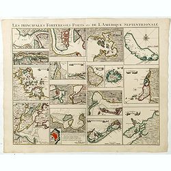
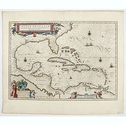
Les Principales Forteresses Ports &c de L'Amérique Septentrionale. . .
This sheet contains 19 small but detailed maps and plans of harbours, towns, forts and islands from the eastern seaboard and the West Indies, all but one plan with title ...
Place & Date: Amsterdam, 1733
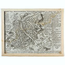
Novae Urbis Hierosolymitanae topographica delineatio . . .
A very rare plan of modern Jerusalem oriented to the east, according to a note on the map the map was drawn after a map by Peter Laicstain. A lettered key to the right.Up...
- $2500 / ≈ €2339
Place & Date: Antwerp, 1571
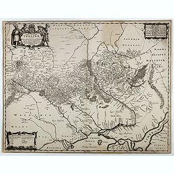
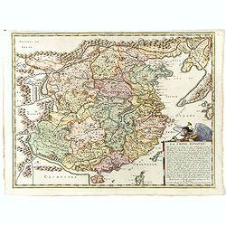
Typus Generalis Ukrainae sive Palatinatuum Podoliae, Kioviensis et Braczlaviensis terras nova delineatione exhibens. . .
A key map engraved by Johannes Janssonius in about 1656 and based on Guillaume La Vasseur de Beauplan's map of the region published in "Description d'Ukraine". ...
- $2000 / ≈ €1871
Place & Date: Amsterdam, ca. 1657
La Chine Royaume. . .
An important and attractive French map of the whole of China, northern tip of the Philippines, with a strangely curved Korea and an under-sized Taiwan here called "Y...
Place & Date: Paris, 1656
![[2 maps] Das Europa der Zukunft... / Das heutige Europa…[The Europe of the Future / The Europe of Today]](/uploads/cache/48735-250x250.jpg)
[2 maps] Das Europa der Zukunft... / Das heutige Europa…[The Europe of the Future / The Europe of Today]
A pair of very scarce WWI German maps highlighting Europe as it currently was, and Europe as it may become. The maps were produced as part of an 8 page booklet produced b...
- $2750 / ≈ €2573
Place & Date: Paris, 1917
Destruccio Iherosolime.
The view shows the destruction of Jerusalem. Major points in the city are identified with Latin notations. Of interest, in the upper left of the image are two figures...
- $2000 / ≈ €1871
Place & Date: Nuremberg, 12 July 1493
Isola del Giapone e penisola di Corea.
A most attractive and decorative map of Japan and its near neighbour Korea by Vincenzo Coronelli. An elaborate central title cartouche garlanded with intertwined flowers ...
- $2000 / ≈ €1871
Place & Date: Venice, 1692
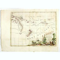
Nuova Guinea e Nuova Galles ed Isole Adjacenti
Map of the South Pacific, showing the sailing routes to the South Pacific by Carteret and Byron, but most importantly the discoveries made by Captain Cook, 1768-1771. The...
- $1750 / ≈ €1638
Place & Date: Venise, 1794-1796
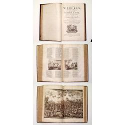
Alle De Wercken, soo Oude als Nieuwe van den Heer Jacob Cats, Ridder, oudt Raadtpensionaris Van Hollandt, &c. : Op nieus vermeerdert met des Autheurs Tachtig-jarig Leven, Huyshoudinge en Bedenckingen op Zorg-vliet.
A very good example of the collected works of the most celebrated Dutch author of the seventeenth century. Illustrated with over 400 engravings after van de Venne by Hond...
- $1900 / ≈ €1778
Place & Date: Amsterdam, 1700
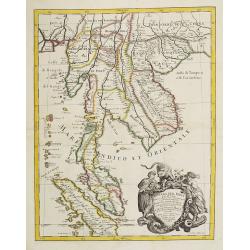
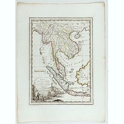
Penisola Dell India di la dal Gange Diusa ne i Regni, che in essasi contengono et accresciuta di varie notizie. Da Giacomo Cantelli da Vignola e conforme le Relationi di alcuni Padri della Compa di Giesu di Monsu Tavernier . . .
Giacomo Rossi's fine late 17th-century map of Malaysia, Thailand, Cambodia and part of Sumatra. The region is shown divided into kingdoms, including Tonkin, Cochinchina, ...
- $2200 / ≈ €2059
Place & Date: Rome, 1683-1688

Il vero ritratto di Nettvno al presente oaupato da gl'imperiali.
Rare and early town-plan of Nettuno, in the province of Rome, which is nowadays a touristic harbor.Issued by Joannes Orlandi who acquired many Lafreri plates, which he re...
- $2700 / ≈ €2526
Place & Date: Rome, 1557 / 1602
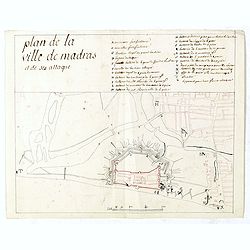
Plan de la ville de Madras et de ses attaques.
Manuscript map, in black, brown and red ink, showing the fortifications of the city of Madras, now Chennai, on the east coast of India, north of Pondicherry.Showing the c...
- $2000 / ≈ €1871
Place & Date: Paris, ca 1760

Mare Balticum. . . / Nieuwe Pascaert van de Oost Zee. . .
Decorative chart showing the Baltic sea, with a splendid cartouche of royal figures. A re-issue of the De Wit copper plates, now with many improvements.
- $2500 / ≈ €2339
Place & Date: Amsterdam ca.1680
Tabula Russiae.
A re-issue, by Willem Blaeu, of Hessel Gerritsz' rare and influential map of Russia.This fine map was compiled from manuscripts brought back from Russia, by Isaac Massa t...
- $1800 / ≈ €1684
Place & Date: Amsterdam, 1644
India Orientalis.
Published in Hondius' editions of the Mercator Atlas from 1606 onwards, showing the Indian subcontinent, the Malay Peninsula, Siam and Cambodia, China and the Philippines...
- $2000 / ≈ €1871
Place & Date: Amsterdam, 1630

Introduction a la Geographie
Engraved title, with 91 double-page engraved maps mostly including European nations, but including World and continents, Turkey, the Holy Land, Persia, China, Japan, Egyp...
- $3000 / ≈ €2807
Place & Date: Paris, 1756
Orbis terrarum typus de integro in plurimis emendatus auctus et icunculis illustratus.
Outstanding and rare example of a bible world map based on the Visscher bible map from 1657 (Shirley 401/414). This map is larger in size and has an extra engraved frame ...
- $2000 / ≈ €1871
Place & Date: Minden, 1729
La Penisola delle Indie di la' dal Gange con parte delle Isole della Sonda delineate sulle ultima osservazioni.
Cassini’s splendid early map of Indochina, from Bangladesh in the west to central Borneo in the east, and southern China in the north, to Bali in the south. Good detail...
Place & Date: Rome, Calcography, 1797-before 1839
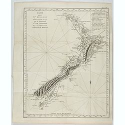
Carte de la Nouvelle-Zelande visitée en 1769 et 1770 par le Lieutenant J. Cook.
Original French Edition of James Cook's Chart of New Zealand, from the First French Edition of Hawkesworth's Voyages. Map of New Zealand, engraved by Bernard. The most im...
Place & Date: Paris, 1774

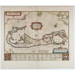
Mappa Aestivarum Insularum alias Barmudas.
Blaeu based his work on John Speed's remarkably accurate map of 1626-1627. It shows the island divided into tribes and lots, and below the map itself appear the names of ...
- $2200 / ≈ €2059
Place & Date: Amsterdam, 1662
Le Insole della Sonda
Cassini’s splendid early map of Philippines, and Indonesia..Taken from the ""Nuovo Atlante Geografico Universale delineato sulle ultime osservazioni", pu...
Place & Date: Rome, Calcography, 1797-before 1839

De custen van een deel van Denemarken en Swede. . .
A detailed chart of the coast Skane and Kalmar, with the island Öland. Decorated by a title and scale cartouche, a compass rose, several vessels and sea monsters, and de...
- $2000 / ≈ €1871
Place & Date: Leiden, Plantijn, 1585
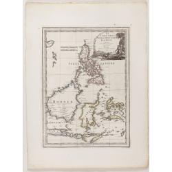
![Isole dell 'India cioè le Molucche le Filippine e della Sonda . . . [East Indies].](/uploads/cache/39593-250x250.jpg)
Isole dell 'India cioè le Molucche le Filippine e della Sonda . . . [East Indies].
In lower left hand corner a large title cartouche, decorated with mermaids, mermen and playful putti. A scarce, uncommon, late 17th century map of South East Asia, based ...
- $1800 / ≈ €1684
Place & Date: Rome, 1683
![Peruviae Auriferae Regionis Typus [with] La Florida Auctore Hieron Chiaves [with] Guastecan Reg.](/uploads/cache/60004-250x250.jpg)
Peruviae Auriferae Regionis Typus [with] La Florida Auctore Hieron Chiaves [with] Guastecan Reg.
The Chaves map of Florida is a prime example of an explorer's map since it records the recent discoveries of Cabeza de Vaca, De Soto, and Moscoso. The map revealed little...
- $2000 / ≈ €1871
Place & Date: Antwerp, 1598
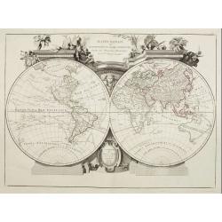
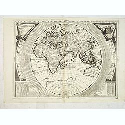
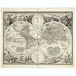
Mappa Monde ou description du globe terrestre . . .
Double hemisphere world map. California is not an island anymore, but a large Mer de l'Ouest is shown. Delineation between New Holland (Australia) and New Guinea is not y...
- $2200 / ≈ €2059
Place & Date: Venice, 1776 - 1784
System of Penal Law, prepared for the State of Louisiana , comprising codes of offenses and punishments, of procedure, of prison discipline, and of evidence applicable as well to civil as to criminal cases.
The "Enquiries" of Rush and Bradford and the Pennsylvania movement toward abolition of the death penalty had a little immediate impact on the practices of other...
- $2500 / ≈ €2339
Place & Date: New-Orleans, Benjamin Levy, 1824