Browse Listings in America

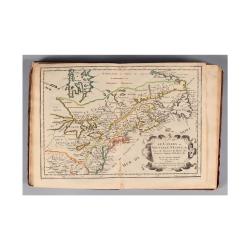
Connecticut and Parts adjacent at Amsterdam. .
A nice example of this early map of the state of Connecticut with part of Rhode Island to the east, Long Island to the south, and New York to the east. Rivers, roads, t...
- $30000 / ≈ €28072
Place & Date: Amsterdam, 1780
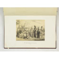
(Album Pallière. Escenas Americanas. Reduccion de Cuadros, aquarelles y bosquejos.)
51 (of 52 )beautifully lithographed plates on tinted ground, lithographed by J. Pelvilain after designs by Juan Léon Palliere. One plate missing : santiagueña tejiendo ...
- $10000 / ≈ €9357
Place & Date: Buenos Aires, en venta en la casa de los S.res Fusoni H.nos, ca. 1850

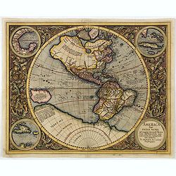
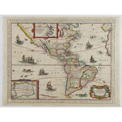
Americae Nova Tabula.
An inset shows Greenland and Iceland. Decorative elements include ships, sea monsters, and vignettes of native Americans within South America. In addition, the map is bor...
- $7500 / ≈ €7018
Place & Date: Amsterdam, 1644
![Le Isole di Sandwich delineate sulle osservazioni del Cap Cook. [Hawaii]](/uploads/cache/43195-250x250.jpg)
Le Isole di Sandwich delineate sulle osservazioni del Cap Cook. [Hawaii]
FIRST EDITION on laid paper. Cassini’s splendid map depicts Sandwich islands, old name for Hawaii islands, at the end of the eighteenth century. The splendid cartouche ...
Place & Date: Rome, 1798

Americae Nova Tabula.
The delineation of the coast and the nomenclature on both the Pacific and Atlantic coasts are basically Spanish in origin and follow the maps of Ortelius and Wytfliet. To...
- $7500 / ≈ €7018
Place & Date: Amsterdam, 1645

.Pascaerte Vande Zuyd-Zee tusschen California, en Ilhas de Ladrones. . .
A decorative and most interesting map - being one of the earliest of the Pacific to record the observations of Tasman's voyages. The northern part of the island of Califo...
Place & Date: Amsterdam, 1666
L'Amerique, en plusieurs cartes nouvelles, et exactes, &c. En divers traitez de geographie, et d'histoire. Là où sont descrits succinctement, & avec une belle Methode, & facile.
Third edition, the text and maps of which are identical to the first given in 1657. However, the dedication to Nicolas Fouquet (2 pp.), disgraced in 1661, has been delete...
- $4500 / ≈ €4211
Place & Date: Paris, 1680

L'Amérique divisée en ses principaux Etats Dressée d'après les Cartes de Mr. Bonne?
Rare, wall map of America in 2 sheets, after R. Bonne. With 3 inset maps of Hispaniola, Martinique and Hudson Bay. Beautiful title cartouche depicting a Native American l...
Place & Date: Paris, 1788
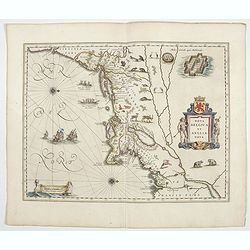
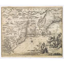
Nova Belgica et Anglia Nova.
Orientated with north to the right. This is one of the earliest maps to concentrate solely on this area of the colonies, excluding Virginia and the extreme north east coa...
- $4500 / ≈ €4211
Place & Date: Amsterdam, 1644

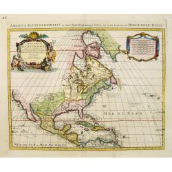
Nova tabula geographica complectens borealiorem..
A finely engraved pair of maps designed to be cut and joined together to provide a continuous coastline of North America from the Carolinas to Newfoundland and along the ...
Place & Date: Amsterdam 1720
America sive India Nova.
This map was created by Michael Mercator, grandson of the great Gerard Mercator. It is the only map attributed to him. The map first appeared in 1595, one year after the ...
- $3000 / ≈ €2807
Place & Date: Amsterdam, 1630
Carte de L'AMERIQUE Corrigeé et argumenteé….
Separately published map published in 1658 but based on Petrus Bertius map of 1624., this on its turn taken from Jodocus Hondius map of 1618. On the sides he lists the pr...
Place & Date: Paris, 1658
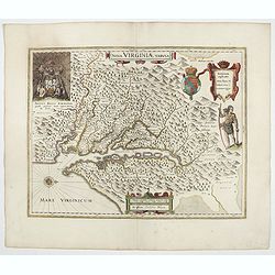
Nova Virginiae Tabula.
The map is based on the first state of Smith's map, 1612, and is slightly larger and more expertly engraved. In 1629 the Hondius plate was purchased by Blaeu who deleted ...
Place & Date: Amsterdam, 1644

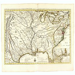
Carte des Possessions Françoises et Angloises dans le Canada, et partie de la Louisiane.
First state of this separately published map of the European Colonies in the New World east of the Mississippi River. This map was published in 1756 to provide informatio...
Place & Date: Paris, 1756

Nieuwe Wassende Graade Zee Kaart over de Spaanse Zee Vant Kanaal tot 't Eyland Cuba in Westindia. . .
¤ Engraved by I.van Anse. A very representative example of a Dutch chart of the Atlantic, showing the north-east coast of America, the coasts of Africa and Europe and So...
Place & Date: Amsterdam, 1728

Carte de la Nouvelle France, ou se voit le cours des Grandes Rivieres de S. Laurens & de Mississipi..
Derived from de Fer's 1718 map, from west of the Mississippi it contains a mass of inland detail with notes and vignettes of the indigenous peoples and fauna of North Ame...
- $2700 / ≈ €2526
Place & Date: Amsterdam, 1720
![A Map of the United States and Canada, New-Scotland, New-Brunswick and New-Foundland ... [together with] A Map of the West-Indies and of the Mexican-Gulph...](/uploads/cache/39235-250x250.jpg)
A Map of the United States and Canada, New-Scotland, New-Brunswick and New-Foundland ... [together with] A Map of the West-Indies and of the Mexican-Gulph...
A Map of the United States and Canada, New-Scotland, New-Brunswick and New-Foundland / Carte des Etats Unis, avec Le Canada, la Nouvelle Ecosse, le Nouveau Brunswick &...
Place & Date: Paris, 1806

Amérique Septentrionale .. Les Etats Unis..
Very rare state: probably separately issued. Published the same year the Treaty of Paris was signed, this is one of the first maps to provide printed boundary lines for t...
- $3000 / ≈ €2807
Place & Date: Paris, 1786

Nova Virginiae tabula.
A fine example of Blaeu's map of Virginia and the Chesapeake region is based on the first state of Smith's map, 1612, and is slightly larger and more expertly engraved.Th...
Place & Date: Amsterdam, 1635/1660

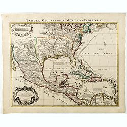
La parte orientale dell' antico.. messico con la Florida..
A splendid two-sheet map of Mexico, including California, Arizona, New Mexico, part of Texas, Baja California and Mexico (west part) and of the Southeast Part of the US, ...
Place & Date: Rome, Calcography, 1797-before 1839
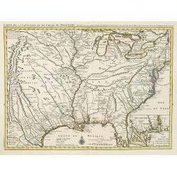
Carte de la Louisiane et du Cours du Mississipi Dressée sur un grand nombre de Memoires..
Covens & Mortier's issue of Delisle's influential map of the French possession of Louisiana. Updated to include New Orleans. When originally published in 1718, it was...
- $2400 / ≈ €2246
Place & Date: Amsterdam, c. 1745
Carte de la Louisiane et du Cours du Mississipi Dressée sur un grand nombre de Memoires. . .
Covens & Mortier's issue of Delisle's influential map of the French possession of Louisiana. Updated to include New Orleans.When originally published in 1718, it was ...
Place & Date: Amsterdam, c. 1745
Selling price: $1400
Sold in 2010
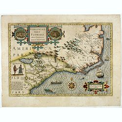
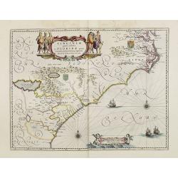
Virginiae item et Floridae. . .
Cummings describes it as one of the most beautifully executed maps ever made of the Southeast. In detail and in general conception it surpasses all earlier maps of the re...
- $2500 / ≈ €2339
Place & Date: Amsterdam, 1630

Tartariae sive Magni Chami Imperium.
This is a very early depiction of the northern Pacific, with the first mapping of Northwest Coast of America and probably the first map to name California 'C. Califormio...
- $2500 / ≈ €2339
Place & Date: Antwerp, c. 1608-1612

Avantures du Sr. C. Le Beau, avocat en parlement ou Voyage curieux et nouveau parmi les Sauvages de l'Amérique Septentrionale. Dans lequel on trouvera une Description du Canada… Ouvrage enrichi d'une Carte et des figures necessaires.
A description of Huron, Iroquois, and Algonquin customs, written in charming style and based, the Author claims, on observations made on a trip to America in 1729." ...
- $2500 / ≈ €2339
Place & Date: Amsterdam, 1738
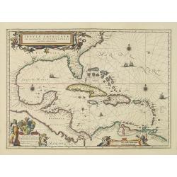
Insulae Americanae in Oceanus Septentrionali cum Terris..
General map of the West Indies extending from Virginia to the mouth of the Orinoco, and destined to be copied in various shapes by many other publishers.Title cartouche t...
- $2500 / ≈ €2339
Place & Date: Amsterdam, 1644
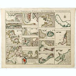
Les Principales Forteresses Ports &c de L'Amérique Septentrionale. . .
This sheet contains 19 small but detailed maps and plans of harbours, towns, forts and islands from the eastern seaboard and the West Indies, all but one plan with title ...
Place & Date: Amsterdam, 1733
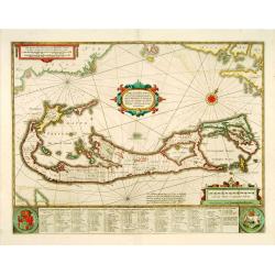
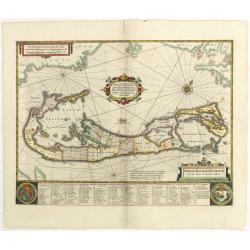
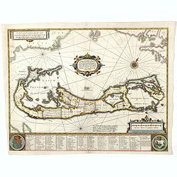
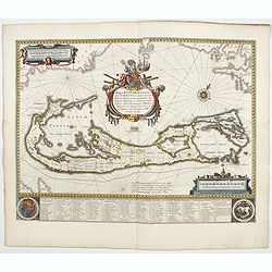
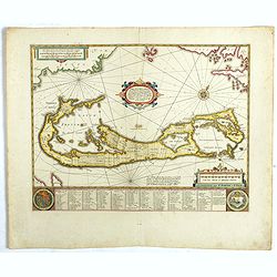
Mappa Aestivarum Insularum, alias Barmudas. . .
It shows the island divided into tribes and lots, and below the map itself appear the coats of arms of Bermuda and England and the names of the first proprietors and the ...
- $2000 / ≈ €1871
Place & Date: Amsterdam, 1645
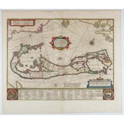
Mappa Aestivarum Insularum, alias Barmudas..
This magnificent map is based on the famous survey by John Norwood of the Bermuda Company in 1618. The map shows the division into the original Tribes and shows the vario...
- $2000 / ≈ €1871
Place & Date: Amsterdam, 1640
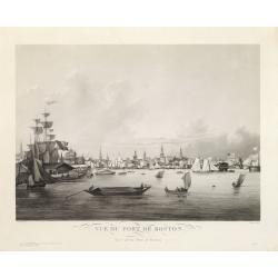
Vue du Port de Boston. View of the Port of Boston.
Superb aquatint of Boston harbor. Painted by L. Garneray and engraved by Himely. Published by Hocquart in Paris and Bailly Ward and Co. of New York.Second state with the...
- $2200 / ≈ €2059
Place & Date: Paris, ca. 1834

Mappa Aestivarum Insularum alias Barmudas.
Blaeu based his work on John Speed's remarkably accurate map of 1626-1627. It shows the island divided into tribes and lots, and below the map itself appear the names of ...
- $2200 / ≈ €2059
Place & Date: Amsterdam, 1662
![Peruviae Auriferae Regionis Typus [with] La Florida Auctore Hieron Chiaves [with] Guastecan Reg.](/uploads/cache/60004-250x250.jpg)
Peruviae Auriferae Regionis Typus [with] La Florida Auctore Hieron Chiaves [with] Guastecan Reg.
The Chaves map of Florida is a prime example of an explorer's map since it records the recent discoveries of Cabeza de Vaca, De Soto, and Moscoso. The map revealed little...
- $2000 / ≈ €1871
Place & Date: Antwerp, 1598
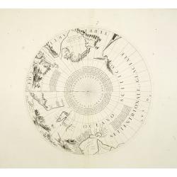
Two polar calottes from a globe.
Two polar calottes from 110 centimeters in diameter globe of 1688 including the northern part of Baffin Bay, Greenland, Iceland, Nova Zembla. Coronelli elected to follow ...
Place & Date: Venice, 1696

Amerique Septentrionalis..
A handsome map showing California as an island, open-ended Great Lakes and other details based mainly on Sanson. A large decorative cartouche occupies the area of the nor...
Place & Date: Paris, after1694

Pascaerte vande Vlaemsche, Soute, en Caribesche Eylanden, als mede Terra Nova,. . .
This fine and scarce sea chart covers the central Atlantic and extends to include the Maritime Provinces, Antilles and the northwest coast of South America, east to the A...
Place & Date: Amsterdam, 1672

Pascaerte van Carybes, Nieu Neder landt, Brazil. . .
This progenitor chart covers the American shores of the Atlantic Ocean. This chart by Theunis Jacobsz. was most probably engraved close to his death in 1650 or shortly af...
- $2200 / ≈ €2059
Place & Date: Amsterdam, 1653-1681
Mappa Aestivarum Insularum, alias Barmudas.
This magnificent map is based on the famous survey by John Norwood of the Bermuda Company in 1618. The map shows the division into the original Tribes and shows the vario...
- $2000 / ≈ €1871
Place & Date: Amsterdam, 1645
![Etats-Unis de L'Amerique Septentrionale. [Two sheets in manuscript ]](/uploads/cache/03972-250x250.jpg)
Etats-Unis de L'Amerique Septentrionale. [Two sheets in manuscript ]
Two sheets giving an detailed information in French, about population in the year 1810, principal cities, products of industry and commerce, financial situation for the y...
- $2000 / ≈ €1871
Place & Date: France, ca. 1819

System of Penal Law, prepared for the State of Louisiana , comprising codes of offenses and punishments, of procedure, of prison discipline, and of evidence applicable as well to civil as to criminal cases.
The "Enquiries" of Rush and Bradford and the Pennsylvania movement toward abolition of the death penalty had a little immediate impact on the practices of other...
- $2500 / ≈ €2339
Place & Date: New-Orleans, Benjamin Levy, 1824
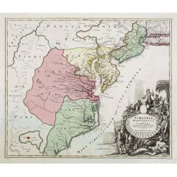
Virginia Marylandia et Carolina..
An attractive and detailed map, covering the coastline from Long Island in the north to just south of Cape Feare in Carolina, with the large fictitious Apalache Lacus in ...
- $2000 / ≈ €1871
Place & Date: Augsburg, 1740
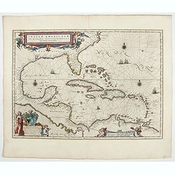
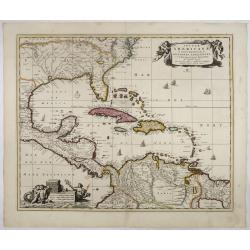
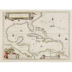
Insulae Americanae in Oceano Septentrionali cum Terris adiacentibus.
General map of the West Indies extending from Virginia to the mouth of the Orinoco, and destined to be copied in various shapes by many other publishers.Title cartouche t...
- $1800 / ≈ €1684
Place & Date: Amsterdam, 1638
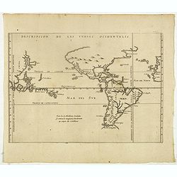
Descripcion de las Yndias Ocidentalis.
Rare early general map of America, the Pacific Ocean and the Eastern part of Asia. Showing "Meridiano de la demarcacion porla parte oscidental" - and "... ...
- $1750 / ≈ €1638
Place & Date: Amsterdam, Michel Colin, 1622
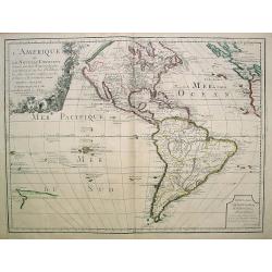
L'Amerique ou le Nouvelle Continent.. Dedieé et presenteé a monseigneur Law.
State one. The map has been prepared by Jean Baptiste Nolin (the elder) has a dedication to Monseigneur LAW controlleur general des finances .Rare general map of the Amer...
- $2200 / ≈ €2059
Place & Date: Paris, 1720
Mappa Aestivarum Insularum, alias Barmudas..
Based closely on Blaeu's map of 1630 but with a simpler centered title piece. The map includes the arms of Bermuda and England, and lists proprietors of the various tribe...
Place & Date: Amsterdam, 1645

Antiguedades Peruanas (Atlas).
Atlas illustrated with 60 chromolithographic and tinted lithograph plates including illustrated title page.This atlas volume was produced to accompany a landmark collabor...
- $1800 / ≈ €1684
Place & Date: Vienna (Austria), 1851
Insulae Americanae in Oceano Septentrionali..
A particularly handsome map portraying the south-eastern U.S., the Caribbean islands, part of Mexico, Central America, Florida (called tegesta Prov. ) and part of South A...
- $1500 / ≈ €1404
Place & Date: Amsterdam, 1702
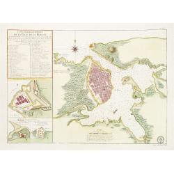
Carte Hydrographique de la Baye de la Havane.. N° 69.
A well-engraved and highly detailed chart of the walled city of Havana and its harbor features inset plans of three forts (La Punta, El Morro, and La Real Fuerza) as well...
- $2000 / ≈ €1871
Place & Date: Paris, 1762

Nieuwe Wassende Graade Zee Kaart over de Spaanse Zee Vant Kanaal tot 't Eyland Cuba In Westindia.
Rare two-sheet blue-back sea chart of the Atlantic and Eastern part of North America., published by Gerard Van Keulen. The map extends from the latitude of Newfoundland a...
- $2000 / ≈ €1871
Place & Date: Amsterdam, ca. 1728-1751

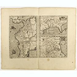
La Florida/ Peruviae Auriferae regionis Typus/ Guastecan.
The Chaves map of Florida is a prime example of an explorer's map since it records the recent discoveries of Cabeza de Vaca, De Soto, and Moscoso. The map revealed little...
- $1400 / ≈ €1310
Place & Date: Antwerp, 1592
L'Amerique septentrionale, Dressée sur les memoires les plus recens. . . MDCCLVII
A rare map of North America, showing good detail, especially in the region between the Appalachians and the Mississippi and the course o the Mississippi to its source, wh...
- $1500 / ≈ €1404
Place & Date: Amsterdam, 1757
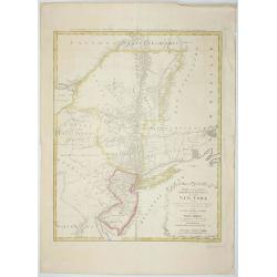
Mappa Geographica provinciae Nova.. NEW-YORK..
This map afforded British commanders during the Revolution an excellent overview of areas that would be crucial in the early years of the war, in particular the Hudson Va...
- $1500 / ≈ €1404
Place & Date: Nuremburg, 1778
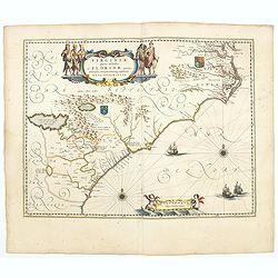
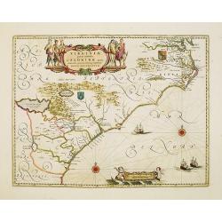
Virginiae Partis Australis, et Floridae Partis Orientalis.
Blaeu based this map on the Mercator-Hondius of 1606. A number of geographical improvements, however were incorporated, although two large fictions lakes accompanied by e...
- $1500 / ≈ €1404
Place & Date: Amsterdam, 1658
Virginiae Partis Australis, et Floridae Partis Orientalis.
Blaeu based this map on the Mercator-Hondius of 1606. A number of geographical improvements, however were incorporated, although two large fictions lakes accompanied by e...
- $2000 / ≈ €1871
Place & Date: Amsterdam, 1644
Mappa Aestivarum Insularum alias Barmudas.
Blaeu based his work on John Speed's remarkably accurate map of 1626-1627. It shows the island divided into tribes and lots, and below the map itself appear the names of ...
- $2000 / ≈ €1871
Place & Date: Amsterdam, 1644

Carte nouvelle de l'Amérique angloise contenant tout ce que les Anglois possèdent. . . avec la Floride / gravée. . . par Maththias Albert Lotter. . .
As mentioned in the title piece, the map includes the area at that time in the possession of the English, i.e. Canada, New Large, beautiful and detailed map of the Easter...
Place & Date: Augsburg, 1777

Nieuwe gemeten kaart van de colonie de Berbice : met der zelver plantagien en de namen der bezitters in het ligt gebragt door Reiner & Iosua Ottens kaartverkopers te Amsterdam 1740.
Rare separately published map of the colony of Berbice in present-day Guyana showing the Berbice River Valley and the plantations along the river. North on map of the col...
Place & Date: Amsterdam, 1740
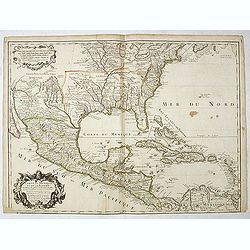
Carte du Mexique et de la Floride, des terres angloises et des isles Antilles, du cours et des environs de la rivière Mississipi. . .
A Dutch edition of De L'Isle's map. It was the first printed map to portray accurately the course and mouth of the Mississippi River. Showing the explorations of d'Ibervi...
Place & Date: Amsterdam, 1722
Novi Belgii, quod nunc Novi Jorck vocatur, Novaeque Anglia et partis Virginiae. . .
A beautifully engraved map, derived from the highly influential map by Visscher. The decoration of this finely engraved map has in the lower right corner not longer a vie...
Place & Date: Amsterdam, 1673
Selling price: $1000
Sold in 2016
L'Amerique septentrionale, Dressée sur les memoires les plus recens. . .
A very detailed map extending from Hudsons Bay to Panama, and including the West Indies. The map is a later copy of Guillaume de L'Isle's foundation map of North America,...
- $1500 / ≈ €1404
Place & Date: Amsterdam, 1740
Carte des troubles De L'Amerique Levée par Ordre du Chevalier Tryon. . . New-York.. Jersey..
A French edition of this uncommon Revolutionary War map describes the region from Salem Massachusetts to Buzzard's Bay south to the Delaware River and west to Lake Ontari...
- $1500 / ≈ €1404
Place & Date: Paris, 1778
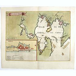
Sinus Omnium Sanctoru. Bahia de Todos os Sanctos.
RARE. First Atlas Major issue: originally issued by Blaeu in Casper van Baarle's 'Rerum per Octennium in Brasilia' (1647) dedicated to the former Governor of the Dutch co...
Place & Date: Amsterdam, 1664

America settentrionale. . .
Rare map of North America drawn directly from the work of Nicholas De Fer and N. Sanson's famous map of 1650. The map is engraved by Antonius Donzel Gallus.With open Grea...
- $2000 / ≈ €1871
Place & Date: Napels, 1766
Virginiae Partis Australis, et Floridae Partis Orientalis.
Blaeu based this map on the Mercator-Hondius of 1606. A number of geographical improvements, however were incorporated, although two large fictions lakes accompanied by e...
- $1800 / ≈ €1684
Place & Date: Amsterdam, 1640

ETATS-UNIS DE L'AMÉRIQUE SEPTENTRIONALE Avec LES ISLES ROYALE, DE TERRE NEUVE, DE S.T JEAN, L'ACADIE, &c. 1785. Supplement a l'Atlas de M. Robert de Vaugondy a Paris Ches Boudet Ingenieur du Roi.
A map of the eastern United States with "Supplément à l'atlas de M Robert de Vaugondy à Paris chez Boudet Imprimeur du Roi", in place of the attribution to D...
- $1750 / ≈ €1638
Place & Date: Paris, 1785

Nova Virginia Tabula.
A beautifully engraved map, derived from the highly influential map by Captain John Smith in 1612, showing Chesapeake Bay and the surrounding area. The decoration of this...
- $1250 / ≈ €1170
Place & Date: Amsterdam, J.Meurs, 1671
Insulae Americanae in Oceano Septentrionali cum Terris adiacentibus.
General map of the West Indies extending from Virginia to the mouth of the Orinoco, and destined to be copied in various shapes by many other publishers. Title cartouche ...
- $1500 / ≈ €1404
Place & Date: Amsterdam, 1658
Mappa Aestivarum Insularum, alias Barmudas..
The map is the rare re-issue of the Blaeu's copperplate of 1630. The map includes the arms of Bermuda and England, and lists proprietors of the various tribes into which ...
- $1600 / ≈ €1497
Place & Date: Amsterdam, 1720
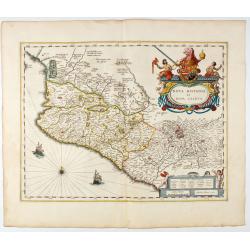
Nova Hispania et Nova Galicia.
Map of New Spain and New Galicia shows the city of Mexico situated by a large lake, as well as the location of many silver and gold mines. The map's elaborate cartouche i...
- $1400 / ≈ €1310
Place & Date: Amsterdam, 1644
Carte du Mexique et de la Floride des Terres Angloises et des Isles Antilles...
Scarce state not listed by Tooley with the imprint : "Chez l’Auteur sur le Quai de l’Horloge a la Cour.r de Diamãs. Avec Privilege du Roy po.r 20 ans, 1703"...
- $1500 / ≈ €1404
Place & Date: Paris, 1703
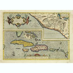
Culiacanae Americae regionis.. / Hispaniolae, Cubae..
Two separate virtually identically sized inset maps on one sheet, each with a decorative scroll title cartouche. Culiacanae depicts the coastal and inland western region...
- $1200 / ≈ €1123
Place & Date: Antwerp 1598

Mappa Geographica provinciae Nova Ebboraci ab Anglis NEW-YORK dictae. . .
During the Revolution, this map afforded British commanders an excellent overview of areas that would be crucial in the early years of the war, particularly the Hudson Va...
- $1500 / ≈ €1404
Place & Date: Nuremberg, 1778

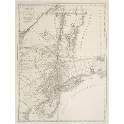
Map of Pensylvania and New Jersey by H.S. Tanner.
First edition of this rare and important map of Pennsylvania and New Jersey by H.S. Tanner and published in his "New American Atlas" from 1823. Includes roads, ...
- $1000 / ≈ €936
Place & Date: Philadelphia, Henry Tanner, 1823

Dominia Anglorum in America Septentrionali.
Four maps on one sheet (New Found land/ New England/ Virginia and Carolina/Florida) based on J.B.Homann's map, showing British possessions in North America. At bottom of ...
- $1500 / ≈ €1404
Place & Date: Nuremberg 1740
La Florida/ Peruviae Auriferae regionis Typus/ Guastecan.
The Chaves map of Florida is a prime example of an explorer's map since it records the recent discoveries of Cabeza de Vaca, De Soto, and Moscoso. The map revealed little...
Place & Date: Antwerp, 1598
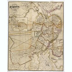
Plan Of Boston Comprising a Part of Charlestown and Cambridge. Published by George G. Smith, Engraver, Washington Street Boston 1855..
Important and detailed plan of Boston, with insets :"Plan Of East Boston from actual Survey by R.H. Eddy" and "Plan Of South Boston From a Drawing by S.P. ...
- $1250 / ≈ €1170
Place & Date: Boston, ca. 1859
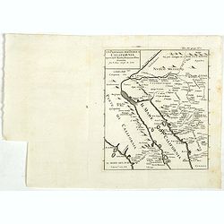
Un Passaggio per Terra a California Scoperto dal P. Eusebio Francesco Kino Gesuita Fragli Anni 1698 et 1701.
The rare Italian edition of Father Eusebio Francisco Kino's seminal map, which definitively ended the myth of California as an Island, which appeared in Saggio delle tran...
- $1200 / ≈ €1123
Place & Date: Napples, 1731
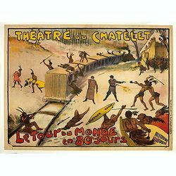
Théâtre du Châtelet. Le Tour du Monde en 80 jours. (The attack of the train).
Theatre poster for "Around the World in Eighty Days by A. Dennery and Jules Verne, for Théâtre du Châtelet, Paris. Printed by : Imprimerie Ch. Wall et Cie, 14 rue...
- $1200 / ≈ €1123
Place & Date: Paris, Imp. Ch. Wall et Cie, ca.1900-1914
Carte du Mexique et des Etats Unis d'Amérique...
A later edition of De l'Isle's foundation map of 1703, widely regarded as one of the most influential maps in the history of American Cartography. This updated version of...
Place & Date: Paris, 1783
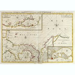
Carte Particuliere de Isthmus ou Darien qui Comprend le Golfe de Panama &c. Cartagena, et les Isles aux Environs.
Finely executed map of a portion of Central America, extending from the East Coast of Nicaragua and Costa Rica in the northwest to Cartagena and Santa Martha in modern Co...
- $1250 / ≈ €1170
Place & Date: Amsterdam, 1720
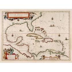
Insulae Americanae in Oceano Septentrionali cum Terris adiacentibus.
General map of the West Indies extending from Virginia to the mouth of the Orinoco, and destined to be copied in various shapes by many other publishers. Title cartouche ...
- $1000 / ≈ €936
Place & Date: Amsterdam, 1635