Browse Listings in Australia & Oceania > Australia
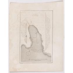
Victoria Harbour.
Chart of Victoria Harbour, showing where stores unloaded, depth readings. Plate from John Ross's Second Voyage in Search of a Northwest Passage, from the book entitled 'N...
Date: London, 1627
![Le Capitaine Wallis est attaqué dans le Dauphin par les Otahitiens. [Tome II Pl. 1ère.]](/uploads/cache/26099-250x250.jpg)
Le Capitaine Wallis est attaqué dans le Dauphin par les Otahitiens. [Tome II Pl. 1ère.]
Scene of an attack by local Tahitians on Captain Wallis' Dolphin ship off Tahiti's shore. Samuel Wallis (1728-95), a Royal Navy Captain and a skilled navigator was given ...
- $150 / ≈ €131
Date: Paris, 1773
![Vue d'un Rocher troué de la Nouvelle Zélande. [Tome III Pl. 8.]](/uploads/cache/29073-250x250.jpg)
Vue d'un Rocher troué de la Nouvelle Zélande. [Tome III Pl. 8.]
A view of a New Zealand landscape and seascape through a hollow rock. Engraved by Demouchy. From the French edition of James Cook's first voyage entitled Relation des voy...
- $75 / ≈ €66
Date: Paris, 1773
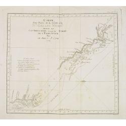
Carte d'une Partie de la Côte, de la Nle Galles Meridle depuis le Cap Tribulation jusqu'au Detroit de l'Endeavour par le Lieut. J. Cook 1770. Tome IV. Pl. 3.
Map of a part of the New galles Meridle Coastline in Australia from the Cap Tribulation to the Endeavour Detroit. This map is taken from the first French edition of Jame...
Date: Paris, 1774
A new and accurate map of Asia, Drawn from the most approved modern maps & charts / by Thos. Bowen.
The map is of interest for the use of Sea of Korea for the sea between Korea and Japan.Detailed map of Asia from Saudi Arabia, Persia, Russia, India, China, Japan to Sout...
Date: London, J.Cooke, 1777-1778
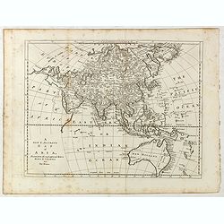
![[Asia and part of Australia]](/uploads/cache/26453-250x250.jpg)
[Asia and part of Australia]
An engraved map of Asia shows an oversized Japan and part of Australia, called Neu Holland. To the east of the Caspian Sea, we see the area of present-day Uzbekistan and ...
- $450 / ≈ €393
Date: Tübingen, Heerbrandt, 1790
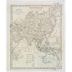
Asia, drawn from the latest Astronomical Observations.
This finely engraved, and detailed, map of Asia shows the extent of knowledge from astronomical observations at the time. It is also of interest for showing Australia her...
Date: London ca. 1808

Voyage de découvertes aux Terres Australes. Historique. Atlas Deuxième partie.
First edition of the second part of the atlas by Freycinet, part of his important book "Voyage de découvertes aux Terres Australes". Illustrated with two foldi...
- $7500 / ≈ €6552
Date: Paris, Langlois, 1811
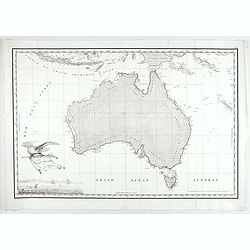
Carte Generale de la Nouvelle Hollande.
Fine map of the continent of Australia prepared by Louis Freycinet during his voyage under Captain Thomas Baudin in 1800-1803. Freycinet's map of New Holland was the firs...
- $5000 / ≈ €4368
Date: Paris, Imprimerie Royale, 1811
![Plan du Port du Roi-George [with] Plan de la Baie du Geographe.](/uploads/cache/46371-250x250.jpg)
Plan du Port du Roi-George [with] Plan de la Baie du Geographe.
Two maps on one sheet, King George Sound and Geographe Bay, now Busselton and Dunsborough area and the earliest chart of this area, from Voyage de découvertes aux terres...
- $500 / ≈ €437
Date: Paris, 1807-1816
![Plan des Iles Jérôme [with] Plan des Iles Berthier [with] Plan du Comté de Cumberland.](/uploads/cache/46370-250x250.jpg)
Plan des Iles Jérôme [with] Plan des Iles Berthier [with] Plan du Comté de Cumberland.
Three maps on one sheet, Jérôme islands, Berthier islands and Cumberland county, from Voyage de découvertes aux terres Australes by François Péron, 1824. The French ...
- $100 / ≈ €87
Date: Paris, 1807-1816
![Plan d'une partie de la Terre Napoléon [with] Plan des Iles Joséphine et de la Baie Murat.](/uploads/cache/46367-250x250.jpg)
Plan d'une partie de la Terre Napoléon [with] Plan des Iles Joséphine et de la Baie Murat.
Two maps showing Descartes Bay and Bridgewater Bay in Victoria and Murat Bay in South Australia showing French discoveries prepared by Louis Freycinet during his voyage u...
- $100 / ≈ €87
Date: Paris, 1807-1816
![Nouvelle-Hollande: Ile Decrès. - Détails du Casoar de la Nouvelle Hollande. [plate XLL]](/uploads/cache/46362-250x250.jpg)
Nouvelle-Hollande: Ile Decrès. - Détails du Casoar de la Nouvelle Hollande. [plate XLL]
Plate illustrating Casoar, by Lesueur, from Voyage de découvertes aux terres Australes by François Péron, 1824.The French expedition under Nicolas Baudin, was commissi...
- $75 / ≈ €66
Date: Paris, 1824
![Nouvelle-Hollande. Gnoung-A-Gnougn-A, Mour-Re-Mour-Ga ( Dit Collins). [plate XVII]](/uploads/cache/46280-250x250.jpg)
Nouvelle-Hollande. Gnoung-A-Gnougn-A, Mour-Re-Mour-Ga ( Dit Collins). [plate XVII]
A portrait of a male Tasmanian Aboriginal Gnoung-A-Gnougn-A, Mour-Re-Mour-Ga ( Dit Collins) by Lesueur, from Voyage de découvertes aux terres Australes by François Pér...
- $100 / ≈ €87
Date: Paris, 1824
![Phisique. [plate XL]](/uploads/cache/40124-250x250.jpg)
Phisique. [plate XL]
Some scientific instruments for measuring the sea temperature at some depth. From Voyage de découvertes aux terres Australes by François Péron, 1824.The French expedit...
- $40 / ≈ €35
Date: Paris, 1824
![Nouvelle-Hollande: Nouvelle Galles du Sud. Navigation. [plate XXIII]](/uploads/cache/40112-250x250.jpg)
Nouvelle-Hollande: Nouvelle Galles du Sud. Navigation. [plate XXIII]
Aboriginal boats, used for hunting and water transportationAfter the original sketches by Lesueur, from Voyage de découvertes aux terres Australes by François Péron, 1...
- $100 / ≈ €87
Date: Paris, 1824
![Nouvelle-Hollande. Oui-Re-Kine. [plate XXI]](/uploads/cache/40110-250x250.jpg)
Nouvelle-Hollande. Oui-Re-Kine. [plate XXI]
A portrait of a female aboriginal residing in Sydney.After the original sketches by Lesueur, from Voyage de découvertes aux terres Australes by François Péron, 1824.Th...
- $100 / ≈ €87
Date: Paris, 1824
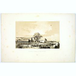
Pecheurs de Tripang a la Baie Raffles.
Fine lithograph of Javanese fishermen in the Bay of Raffles. Located at the eastern end of the Cobourg Peninsula, Raffles Bay was the site of the second abortive attempt ...
Date: Paris, 1842
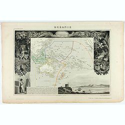
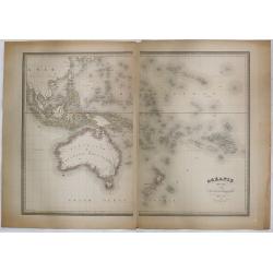
Océanie.
A very decorative 19th century map of the Pacific Ocean, with hand colored lines indicating the extent of Polynesia, Micronesia, Melanesia, and Malaysia (or Southeast Asi...
Date: Paris, 1850
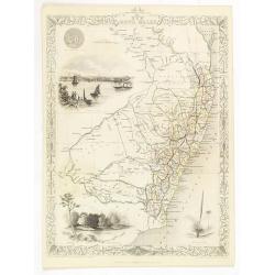
New South Wales.
Decorative steel engraved map of New South Wales, surrounded by illustrations of Sydney Cove, native trees and the seal of New South Wales. Interlocking border design. Ta...
- $300 / ≈ €262
Date: London, ca. 1851
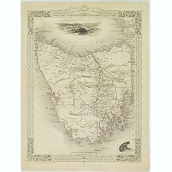
Van Diemen's Island or Tasmania.
Decorative steel engraved map of Tasmania. Taken from "The illustrated atlas and modern history of the world by John Tallis", published between 1849 and 1853. T...
- $225 / ≈ €197
Date: London, 1851
Océanie dressée par A.H. Dufour géographe.
Wall-sized map (87x117cm) in two sheets prepared by Adolphe Hippolyte Dufour, giving good detail to Australia and New Zealand, due to extensive discoveries of the French ...
- $1200 / ≈ €1048
Date: Paris, 1854
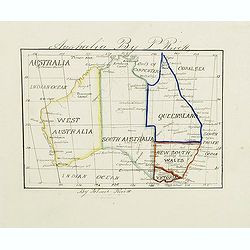
Australia by P.Rivett.
Manuscript map of Australia without Tasmania, prepared by Palmer Rivett, who was born around 1858 in Blundeston, Suffolk, England, where he spent most of his life. He was...
Date: c. 1860-1870
Australie (Côte Est) Feuille N°10 Partie comprise entre La Baie Jervis et le Cap Everard . . .
Large French sea chart featuring the eastern coast of Australia. Engraved by J.Millian. The chart is based on surveys by the British Captn. F.W. Sidney, Staff Comr., H.J....
Date: Paris, 1874
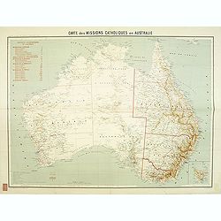
Carte des missions Catholiques en Australie.
Rare and detailed map of Australia (Scale 1:5 000 000) showing Catholic dioceses and bishops' residences, but not missions, on a topographic basis. Relief is shown by hac...
Date: Lyon / Paris, 1906
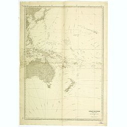
Ocean Pacifique Partie Ouest.
Large French sea chart featuring the western part of the Pacific Ocean with Australia, New Zealand, New Guinea, Philippines, till Korea and Japan, corrected in 1929.On th...
- $450 / ≈ €393
Date: France, 1909-1929
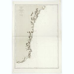
Sheet VI East coast of Australia. New South Wales Tacking Point to Coffs Islands surveyed by Comr. Fredk. W. Sidney R.N. . . 1862 - 1864. . .
Large chart representing East coast of Australia with New South Wales including Tacking Point to Coffs Islands surveyed by Comr. Fredk. W. Sidney R.N. from 1862 - 1864. F...
- $150 / ≈ €131
Date: London, 1939-1942
East coast of Australia. New South Wales. Sheet VII, Coffs Islands to Evans Head surveyed by Comr. Fredk. W. Sidney R.N. assisted by E.P. Bedwell & J.T. Gowlland, Masters & S. Guy, 2nd Master R.N. 1864-5
Large chart representing East coast of Australia with New South Wales including Coffs Islands to Evans Head surveyed by Comr. Fredk. W. Sidney R.N. First published at the...
- $150 / ≈ €131
Date: London, 1907-1943
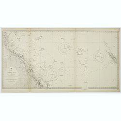
Australia, Coral Sea and Great Barrier Reefs shewing the inner and outer routes to Torres Strait. Sheet 1. . .
Large scale chart representing the Great Barrier Reef and the Coral Sea showing routes to the Torres Strait. Sheet 1.First published at the Admiralty 1860 with new editio...
- $150 / ≈ €131
Date: London, 1869-1943
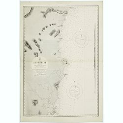
Sheet V East coast of Australia. New South Wales Evans Head to Danger Pt. surveyed by Comr. Fredk. W. Sidney R.N. . . 1864-5. . .
Large chart representing East coast of Australia with New South Wales including Evans Head to Danger Pt. surveyed by Comr. Fredk. W. Sidney R.N. from 1864 - 1865. First p...
- $150 / ≈ €131
Date: London, 1866-1943
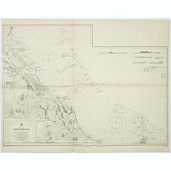
Australia - East coast Queensland Keppel Bay and Islands surveyed by staff Commr. J.Jeffery. . . 1864. . .
Large chart representing East coast of Australia with Queensland including Keppel Bay and Islands surveyed by Comr. J.Jeffery in 1864. First published at the Admiralty 3r...
- $150 / ≈ €131
Date: London, 1866-1943
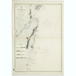
Sheet XI East coast of Australia - Sandy Cape to Keppel isles surveyed by Staff Commr. E.P. Bedwell, Navg. Lieutt. E.H.S. Bray, and Navg. Sub. Lieutt. E.R. Connor, 1870
Large chart representing East coast of Australia from Sandy Cape to Keppel isles surveyed by Staff Commr. E.P. Bedwell. With two inset charts of Pancake Creek. Scale 1:24...
- $150 / ≈ €131
Date: London, 1883-1944
Sheet XII East coast of Australia Queensland Keppel Isles to Percy Isles. . .
Large chart representing east coast of Australia's Queensland showing Keppel Isles to Percy Isles with relief shown by hachures, spot heights and bathymetric soundings. S...
- $150 / ≈ €131
Date: London, 1932-1944
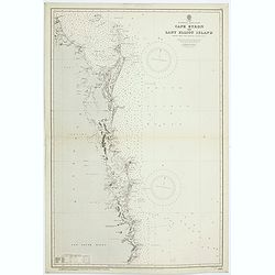
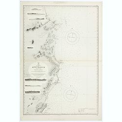
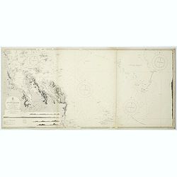
Australia - East coast. Cape Byron to Lady Elliot Island compiled chiefly from Admiralty surveys, 1863-70.
Large chart representing Cape Byron to Lady Elliot Island, Australia, east coast with relief shown by hachures, spot heights and bathymetric soundings. Compiled chiefly ...
Date: London, 1907-1944
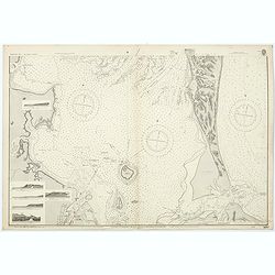
![Australia, E. coast - Queensland Percy isles to Whitsunday I. chiefly from a joint Admiralty & Colonial survey by Staff Commander Bedwell, R.N. 1873 to 1879 [1945]](/uploads/cache/36212-250x250.jpg)
Australia, E. coast - Queensland Percy isles to Whitsunday I. chiefly from a joint Admiralty & Colonial survey by Staff Commander Bedwell, R.N. 1873 to 1879 [1945]
Large chart representing East coast of Australia with Queensland from Percy isles to Whitsunday Island, with inset of Beverley Islands Anchorage. Scale 1:74,000. in lower...
- $150 / ≈ €131
Date: London, 1882-1945
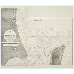
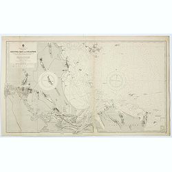
Australia, E. coast - Queensland Moreton Bay
Large chart representing East coast of Australia with Moreton Bay in Queensland.After a survey by Comr. J.Jeffery, etc. in 1865. New edition at the Admiralty 1870. With ...
Date: London, 1882-1945
Australia, E. coast - Queensland Moreton Bay
Large chart representing East coast of Australia with Moreton Bay in Queensland.After a survey by Comr. J.Jeffery, etc. in 1865. New edition at the Admiralty 1870. With ...
- $120 / ≈ €105
Date: London, 1882-1945
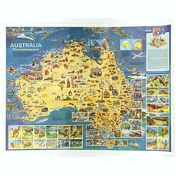
Australia, The Awakening Giant.
This large, fully colored map of Australia was published in America and Australia in the late 1960s. The map is covered in small colored illustrations, connected with loc...
Date: Victoria, 1967
