Browse Listings in Asia > Arabian Peninsular

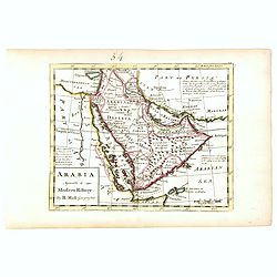
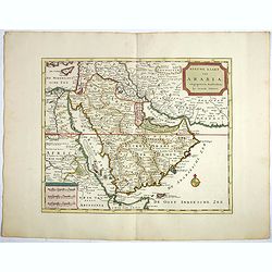
Tabula Sexta Asia (Arabian Peninsula)
This is a very desirable early Ptolemaic woodblock map of the Arabian Peninsula, here called Arabia Felix. The map is presented on a trapezoidal projection with par...
Date: Vienna, 1525 -1541
![[Arabian Peninsula]](/uploads/cache/33869-250x250.jpg)
[Arabian Peninsula]
Wood block printed map and one of earliest printed representation of the Arabian Peninsula prepared by Martin Waldseemüller. Based on the slightly larger map from 1513 p...
Date: Vienna, Trechsel, G., 1525 -1541
![Arabia Felice Nuova Tavola. [Arabian Peninsular]](/uploads/cache/40089-250x250.jpg)
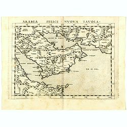
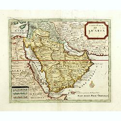
Arabia Felice Nuova Tavola. [Arabian Peninsular]
Fine early map of this modern depiction of the Arabian peninsula, being one of the earliest modern maps of the region. The map extends from the Arabian Desert south as fa...
Date: Venice, Vincenzo Valgrisi, c.1561
Arabia Felice Nuova Tavola.
Uncommon first edition of this modern map of Saudi Arabia, the Persian Gulf and Red Sea, for the first time it "clearly shows the island of Bahrain and Qatar".T...
Date: Venice, Vincenzo Valgrisi, 1561
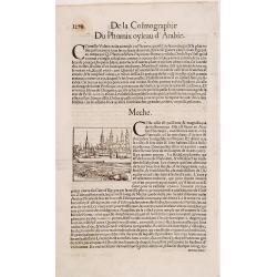
Meche.
Panoramic view of Mecca from Antoine du Pinet's "Plantz, Pourtraitz, Et descriptions De Plusieurs Villes". Woodblock print in text leaf with an interesting desc...
Date: Lyon, 1564
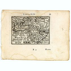
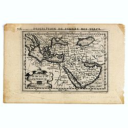
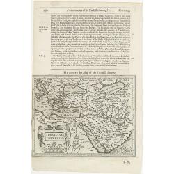
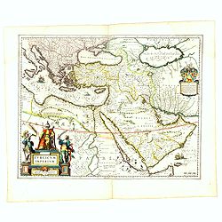
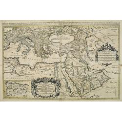
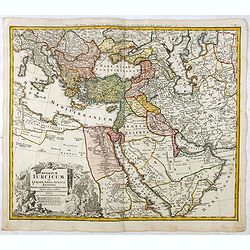
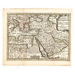
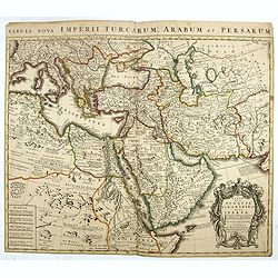
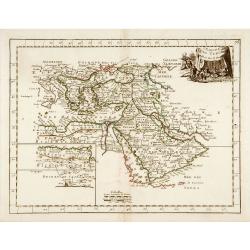
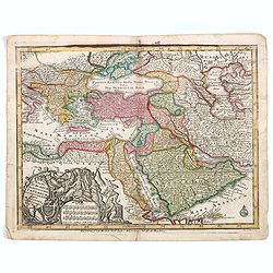
Turcici imperii descriptio.
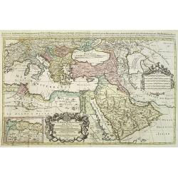
Fine map of the Middle East, extending from Greece to Arabia and covering the Cradle of Civilisation region.Abraham Ortelius (1527-1598) was a cartographer and publisher ...
- $550 / ≈ €480
Date: Antwerp, 1583
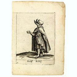
Arabs Nobilis.
Costume plate published by Pietro Bertelli in his "Diversarum nationum habitus", a sixteenth-century Italian costume book. The work was published with fold-out ...
- $70 / ≈ €61
Date: Padua, 1589
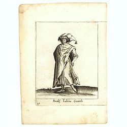
Arabs habitu Gentili.
Costume plate published by Pietro Bertelli in his "Diversarum nationum habitus", a sixteenth-century Italian costume book. The work was published with fold-out ...
- $50 / ≈ €44
Date: Padua, 1589
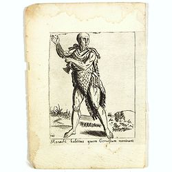
Monachi habitus guem Geruisium nominant.
Costume plate published by Pietro Bertelli in his "Diversarum nationum habitus", a sixteenth-century Italian costume book. The work was published with fold-out ...
- $50 / ≈ €44
Date: Padua, 1589
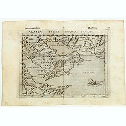
Arabia Felice Nuova Tavola.
Fine early map of Arabian peninsula, being one of the earliest modern maps of the region.Girolamo Ruscelli first published the map in his "La Geographi di Claudio To...
Date: Venice, 1598
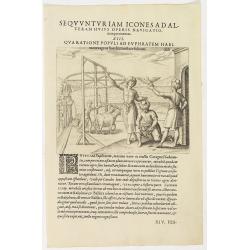
Seqvuntur Iam Icones ad Alteram Huius operis navigationem. . . (Water pump)
Illustration from seventh part of De Bry’s Petits Voyages, including Gasparo Balbi's voyage to Pegu via Syria in 1579-1588. The plate is showing a water pump driven by ...
- $100 / ≈ €87
Date: Frankfurt, 1599
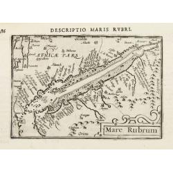
Mare Rubrum.
Very fine miniature map including the Red Sea, Yemen, east coast of the Arabian peninsula. One of the early maps to focus on this area.Engraved by Petrus Kaerius.More abo...
Date: Amsterdam, 1602

Descriptio Arabie / Arabia.
A rare miniature map of the Arabian Peninsular. The title cartouche on the lower right corner.First published in 1598 in his Caert-Thresoor, the plates were executed by t...
Date: Amsterdam, Cornelis Claes, 1606
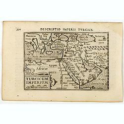
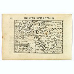
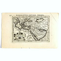
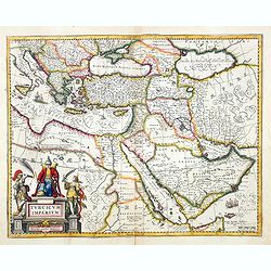
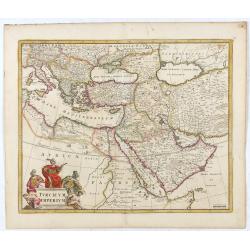
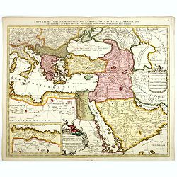
Descriptio Imperii Turcici / Turcicum Imperium.
A rare miniature map of the Arabian Peninsular. Title cartouche on the lower right corner.First published in 1598 in his Caert-Thresoor, the plates were executed by the m...
- $300 / ≈ €262
Date: Amsterdam, Cornelis Claes, 1606
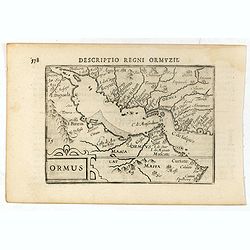
Descriptio Regni Ormuzii / Ormus.
A lovely miniature map of the Kingdom of Ormus, published by Petrus Bertius, and published in Amsterdam at the beginning of the seventeenth century. With an attractive st...
- $450 / ≈ €393
Date: Amsterdam, Cornelis Claes, 1606
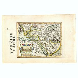
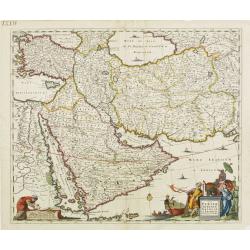
Turcicum Imperium.
A really attractive miniature map of The Turkish Empire, as it was at the beginning of the seventeenth century. Published by Petrus Bertius in Amsterdam. The map stretche...
Date: Amsterdam, 1606
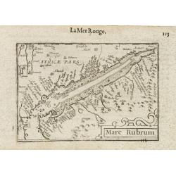
Mare Rubrum / Mer Rouge.
Wonderful miniature map includes the Red Sea, Yemen, and the east coast of the Arabian peninsula. One of the early maps to focus on this area. The title cartouche on the ...
Date: Amsterdam / Frankfurt, 1609
Turicum imperium.
FIRST IMPRINT FROM THE NEWLY ENGRAVED PLATES IN 1616. - A rare miniature map of the Ottoman empire with Turkey and the Arabian Peninsular. Title cartouche on the lower le...
Date: Amsterdam, J. Hondius, 1616
Turcicum Imperium.
FIRST IMPRINT FROM THE NEWLY ENGRAVED PLATES IN 1616. - A rare miniature map of the Arabian Peninsular. Title cartouche on the lower left corner.First published in 1598 i...
- $500 / ≈ €437
Date: Amsterdam, J. Hondius, 1616
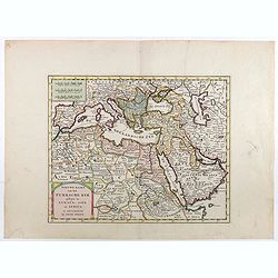
Turcici Imperii descriptio.
Finely and early map of the Turkish Empire giving good detail in the Arabian Peninsula. From Isolario, engraved by Girolamo Porro.Read more about Mapping of Arabia and o...
Date: Padua 1620
Turcicum Imperium.
The rare Samuel Purchas' edition of the Mercator / Hondius "Atlas Minor" atlas map. Early map of Turkey, the Arabian pen insular and eastern part of the Mediter...
Date: London, 1625

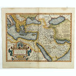
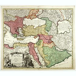
Turcici Imperii Imago.
The map shows the Ottoman Empire with Turkey, Black Sea, Mediterranean Sea, Arabia and North Eastern Africa. The map is decorated with a title cartouche and a portrait of...
Date: Amsterdam, 1629
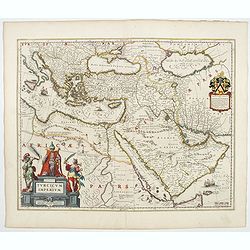
Turcici Imperii Imago.
A very decorative map. On top of title cartouche the portrait of Sultan Mahumet Turcorum Imperat .More about Mapping of Arabia [+]
- $1000 / ≈ €874
Date: Amsterdam, 1633
Turcicum Imperium.
Early map of Turkey, the Arabian peninsula and eastern part of the Mediterranean.From the English edition of Mercator's Atlas Minor. This edition 1635. English text on ve...
Date: Amsterdam, 1635
Turcicum Imperium.
A very handsome map with a particularly fine cartouche showing the Turkish Sultan on his throne and allegorical figures at either side brandishing weapons. At the right i...
- $1800 / ≈ €1572
Date: Amsterdam, 1644
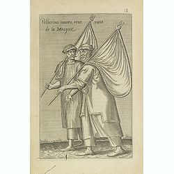
Pellerins mores, reue nuns de la Mecque.
Sought-after copper engraved plate from Laonikos Chalcocondyle’s "L'histoire de la décadence de l'empire grec et establissement de celuy des Turcs." by Thoma...
Date: Paris, Mathieu Guillemot, 1650

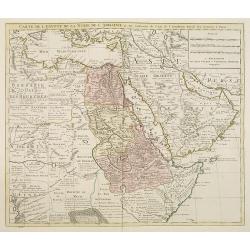
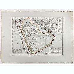
Carte des Trois Arabies. Tiree en Partie de l'Arabe de Nubie, en Partie de Divers autres Autheurs. . .
Rare map of the Arabian Peninsula, first published in 1654 and one of the first large maps focused specifically on the Arabian Peninsula. Sanson's map of the Arabian Peni...
Date: Paris, 1654
Turcicum Imperium.
A very handsome map with a particularly fine cartouche showing the Turkish Sultan on his throne and allegorical figures at either side brandishing weapons. At right is a ...
- $1500 / ≈ €1310
Date: Amsterdam, 1658
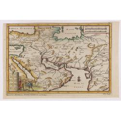
Nova Persiae, Armeniae, Natoliae et Arabiae.
East from Cyprus to Iran with numerous place names and ornamental cartouches below. There are vignettes of sailing ships in sea areas and the land divisions of the time a...
- $850 / ≈ €743
Date: Amsterdam, 1660
Turcicum Imperium. Concordia res parvæ crescunt discordia maximæ dilabuntur.
An impressive and attractive map with a particularly fine cartouche showing the Turkish Sultan on his throne and allegorical figures at either side brandishing weapons.Sa...
- $1100 / ≈ €961
Date: Amsterdam, 1667
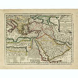
Les Estats De L'Empire Du Grand Seigneur Des Turcs En Europe. . .
Prepared by N.Sanson. The map represents the Ottoman Empire based on Sanson's 1654 map. The Arabian Peninsula is shown with much detail, including towns, villages, mounta...
Date: Paris, 1675
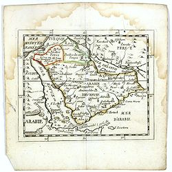
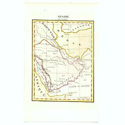
Arabie.
Scarce miniature map of the Arabian peninsular, from Pierre Duval's La Geographie Universeille dated 1676. Following his Cartes de géographie in 1657, Pierre Duval publi...
- $300 / ≈ €262
Date: Paris, 1676
Turcicum Imperium.
Detailed map of the Turkish Empire by Holland's leading mapmaker at the end of the seventeenth century. The cartouche shows an Ottoman administrator or possibly the Sulta...
Date: Amsterdam, 1680
Naukeurige Beschryving van Asie: behelsende de Gewesten van Mesopotamie, Babylonie, Assyrie, Anatolie, of Klein Asie: beneffens eene volkome Beschrijving van gansch Gellukigh, Woest, en Petreesch of Steenigh Arabie.
Fine large paper copy of this important description of the Near East and Arabia, illustrated with numerous text engravings, 15 double page engraved maps (3) and views (12...
Date: Amsterdam, Jacob van Meurs, 1680
Estats de l'empire du grand seigneurs des turcs. . .
The map represents the Ottoman Empire based on Sanson's 1654 map. The Arabian Peninsula is shown with much detail including towns, villages, mountains and watercourses an...
Date: Amsterdam, 1692

Accuratissima et maxima totius Turcici Imperii..
Rare issue of T. Danckert's attractive map showing the Arabian Peninsular, Turkey, Cyprus, Egypt and eastern part of the Mediterranean.Decorative title cartouche lower le...
Date: Amsterdam, 1700
![[Drawing of a Tulip]](/uploads/cache/06621-250x250.jpg)
[Drawing of a Tulip]
Very detailed and well-executed tulip drawing by an unknown artist attributed to the School of Anthony Claesz (1607/8-1649)This drawing was made for a 'Tulip book' painte...
- $1500 / ≈ €1310
Date: The Netherlands c.1700
Imperium Turcicum Complectens Europae, Asiae, et Africae, Arabiae que Regiones ac Provincias Plurimas Industria et Labore . . .
Petrus Schenk's map of the Ottoman Empire, is based upon an earlier map by Sanson. It is showing from Italy to the Caspian Sea and the Saudi Peninsula, centered on Cyprus...
- $1000 / ≈ €874
Date: Amsterdam, circa 1705
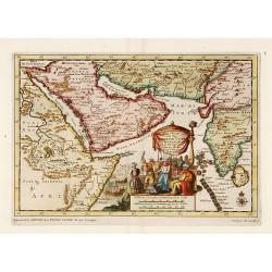
Zee-Togt van den Grooten Turk Uyt het Roode Meyr Tegen de Portugy fen na Indien tot aan Kaap Comorin Ondernomen.
Map of the Arabian peninsula, with Saudi Arabia, the Indian Ocean and India and Ceylon.Although not renowned for the originality of his work, Pieter van der Aa is highly ...
Date: Leiden, 1706
Reys-togt Thomas Coryat van Jerusalem te Land gedaan na Asmere de Hof-Stadt des Grooten Mogols in Oostindien.
The regional map illustrates the narrative of Thomas Coryat's travels by land from Jerusalem to the Court of the Great Mogul. Coryat travelled to Ajmer in India to the co...
- $450 / ≈ €393
Date: Leiden, 1706
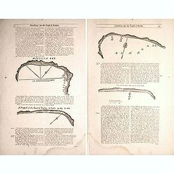
Two double sided pages No's 25 & 26 ‘Directions for the coast of Arabia.' 27 & 28 Directions for the Coast of Persia & ‘Directions for the coast of Arabia
Four woodblock chart’s on two double sided sheets by Samuel Thornton showing the approaching coast lines Arabia by John How and Samuel Thornton. Pages numbered 25,26,27...
- $500 / ≈ €437
Date: London, 1711
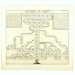
Genealogie de Mahomet.
Fine example of Chatelain's attractive plate showing the genealogy of Mahomet. Zacharie Chatelain (d.1723) was the father of Henri Abraham (1684-1743) and Zacharie Junior...
- $75 / ≈ €66
Date: Amsterdam, 1714
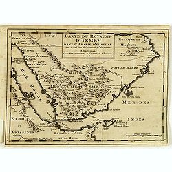
Carte du royaume d'Yémen dans l'Arabie heureuse par G. Delisle. . .
Scarce little map of the Arabian Peninsular after De. L'Isle. From "Voyage de l'Arabie heureuse par l'Océan Oriental et le Détroit de la Mer Rouge. Fait par les Fr...
Date: Amsterdam, 1716
Estats de L'empire du Grand Seigneur dit Sultan et Ottomans Empereur des Turcs. . .
The map shows the extent of the Ottoman Empire from the Balkans to Persia, including all of Arabia and North Africa (an inset map at the lower left shows the continuation...
- $250 / ≈ €218
Date: Paris, 1719

Carte Particuliere d'une Partie d'Asie ou sont Les Isles D'Andemaon, Ceylan, Les Madives . . .
1720 MORIER, P. - The Gulf is called "Golfe de Belsera ou d'El Catif", with a note "Y'ey est la Grande Peche des Perles".
Date: Amsterdam, 1720

A Map of Turky, Arabia And Persia. Corrected from the latest Travels. . .
FIRST EDITION - Fine Turkish Empire map centered on Saudi Arabia, Cyprus and the Mediterranean Sea. Dated 1711, "Sold by John Senex at the Globe aga inst St. Dunstan...
- $1750 / ≈ €1529
Date: London, 1721
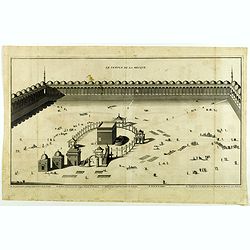
Le Temple de la Mecque.
Striking view of the Temple at Mecca, showing the Kaaba at the center of Islam's most sacred mosque, that is Al-Masjid Al-?aram, in Mecca, Hejaz, Saudi Arabia.The engravi...
Date: The Hague, Isaac Vaillant, 1721
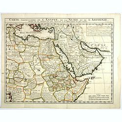
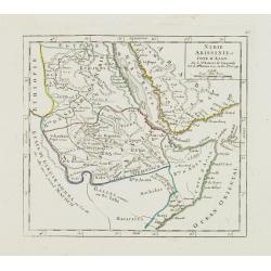
Carte Particuliere De L'Egypte, De La Nubie et de L'Abyssinie, Dressee sur les Memoires les plus Nouveaux & les Observation les plus exactes.
Including the Arabian Peninsular, Egypt, north eastern part of Africa, Cyprus and part of the Mediterranean.Based on the work of Guillaume Delisle. It is a very detailed ...
- $400 / ≈ €349
Date: Amsterdam, 1728
Imperium Turcicum in Europa, Asia et Africa Regiones proprias, tributarias, clientelares sicut et omnes eusdem Beglirbegatus seu Præfecturas Generales exhibens. . .
Johann Baptist Homann's well-engraved map of the Ottoman Empire centered on Cyprus. With good detail in the Arabian Peninsular. In the lower left, a decorative title cart...
- $500 / ≈ €437
Date: Nurnberg, 1737
Imperium Turcicum in Europa, Asia et Africa.
Johann Baptist Homann's well-engraved map of the Turkish Empire, showing from Tunis to Arabia, including Greece, Arabia, Turkey and Palestine. With good detail in the Ara...
- $1000 / ≈ €874
Date: Nurnberg, 1737
Arabia agreeable to Modern History.
Detailed map of the Arabian Peninsula from the Mediterranean Sea to the Arabian Sea, and western Iran. with an engaging text block on upper right corner: "Arabia, d...
Date: London, 1739
(Arabian peninsula, Turkey, Irak).
A very nice map of the Arabian peninsula, Turkey and Irak. From Francisco Giustiniani for El Atlas abreviado o el nuevo compendio de la Geografia universal, politica, his...
- $150 / ≈ €131
Date: Leon de Francia (Lyon), Jaime Certa, 1739
Carta nuova dell'Arabia.
Detailed map of Arabia and environs. Based on a map published by Isaak Tirion in Amsterdam, but here issued by Albrizzi with a modified title.More about Mapping of Arabia...
Date: Venice, 1740

Carte de L'Egypte de la Nubie de L'Abissinie..
Prepared by G.de l'Isle. Uncommon issue by Hendrik de Leth. Very detailed map of northeastern Africa, the Red Sea and the Arabian peninsula shows the political divisions ...
- $500 / ≈ €437
Date: Amsterdam 1740
Estats de L'Empire du Grand Seigneur dit Sultan et Ottomans Empereur des Turcs. . .
The map shows the extent of the Ottoman Empire from the Balkans to Persia, including all of Arabia and North Africa (an inset map at lower left shows the continuation of ...
- $150 / ≈ €131
Date: Amsterdam, 1740
Nieuwe kaart van Arabia.
Here is an attractive map of the Arabian Peninsula, Gelukkig Arabia or Happy Arabia. The map is a great advance on other maps of the time by showing the true extent of...
Date: Amsterdam, 1740
Carte de l'Egypte de la Nubie de l'Abissinie. . .
Detailed copper-engraved map of North-East Africa showing Guinea in the southwest through Ethiopia , the Red Sea to the Persian Gulf.In the northwest, Tunis through Egypt...
Date: Amsterdam, 1745

Plan de la Rade de Gedda situee de la Cote d'Arabie sur la Mer Rouge.
Chart of the area around city of Gedda in the Red Sea. D'Après De Mannevillette (1707-1780) was one of Franc's first hydrographers. When the first edition of his Atlas L...
- $600 / ≈ €524
Date: Paris, 1745
Nubie Abissinie et Cote d'Ajan.
Charming small map showing the Horn of Africa. Included are part of present-day Yemen and the coastline of Saudi Arabia along the Red Sea.From Atlas Portatif Universel, b...
- $100 / ≈ €87
Date: Paris, 1749
Nieuwe kaart van het Turksche Ryk gelegen in Europa, Asia en Afrika. . .
Attractive map of the Mediterranean and countries bordering, extending eastwards to include all the Arabian Peninsula.
- $700 / ≈ €611
Date: Amsterdam, 1750
Carte de la Turquie de L'Arabie et de la Perse.
This is the Amsterdam issue of De L'Isle's map of the Turkish Empire and Arabian Peninsula. It includes the Turkish Empire, the Mediterranean, Central Asia, and parts of ...
Date: Amsterdam, 1751
Carte de L'entrée du Golfe de la Mer Rouge.
Chart of the Gulf of Aden with the coast line of Yemen, the Island Socotra and the entrance of the Red Sea. With 2 inset charts off-shore of the town Mocha.D'Après De Ma...
- $400 / ≈ €349
Date: Paris, 1753
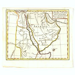
l'Arabie et l'Egypte pour la Concorde de la Géographie des different Ages.
Uncommon map of Arabian Peninsular with a title inland "Arabie Heureuse. . .".More about Mapping of Arabia [+]
Date: Paris, 1765
L'Empire des Turcs.
With decorative title cartouche upper right. Good detail in the Arabian peninsula.More about Mapping of Arabia [+]
Date: Paris, 1767
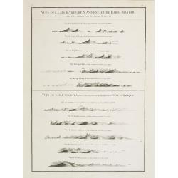
Vues des Cap d'Aden, de St. Antoine, et de Bab-El-Mandeb, sur la Côte Méridionale de l'Arabie Heureuse. Vues de l'Isle de Socotra
Coast profiles near Cape Aden in Yemen and in the lower part coastal profiles near Socotra, an island east of the Horn of Africa and 380 kilometers (240 mi) south of the ...
- $250 / ≈ €218
Date: Paris, Brest, chez Demonville, 1775
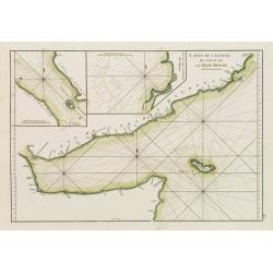
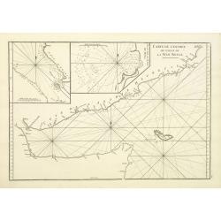
Carte de l'Entrée du Golf de la Mer Rouge. / Plan de La Rade de Moka.
French sea chart of the entry of the Red Sea showing both the African and Arabian coasts. With two inset charts: Plan de La Rade de Moka. and one with the coasts south of...
Date: Paris, ca 1775
Carte de la Mer Rouge, depuis Moka jusqu'a Gedda.
Chart of the Red Sea. With 3 inset maps of Shake Omare, Goofs and Gedan.D'Après De Mannevillette (1707-1780) was one of France's first hydrographers. When the first edit...
- $450 / ≈ €393
Date: Paris, 1775
Magni Turcarum dominatoris Imperium . . .
Uncommon version of this small map of the Ottoman Empire extending from the Balkans and the north African coast through Arabia the Black Sea. Decorated with a small compa...
Date: Augsburg, J.M.Will, 1778
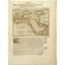
Carte de l'Arabie d'après les différents morceaux qu'a donnés M. Niebuh...
Detailed map of the Arabian peninsular, after Niebuhr, with scales in lower left corner. Engraved by Pierre-Paul Dubuisson.More about Mapping of Arabia [+]
Date: Paris, ca. 1820
Arabie par A.M. Perrot.
Uncommon map of Arabia, prepared by A.M. Perrot and engraved by P Tardieu.More about Mapping of Arabia [+]
Date: Paris, 1835
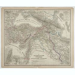
Die Asiatische Türkei. Die Kaukasusländer und West Persien.
Detailed map of Ottoman Asia or the Asian Turkey. Below the title a colored key to Turkish, Iran, Kurd, Caucasus and Russian possessions.Map prepared by H. Kiepert.
- $75 / ≈ €66
Date: Weimar, 1836-1838
Carte de L'Entrée de la Mer Rouge. Dressée par M.Daussy. . .
Very large and detailed chart depicting the entrance of the Red Sea, including the coastline of Yemen with inset "Carte du détroit de Bab!el-Mandeb. . ." and &...
- $750 / ≈ €655
Date: Paris, ca. 1840
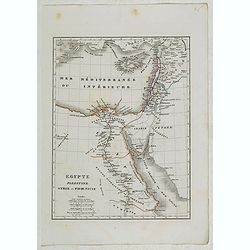
Egypte, Palestine, Syrie et Phoenicie.
Detailed map of Egypt, Palestine, Syria and Phoenicia, prepared by Charles V. Monin (fl.1830-1880) a French cartographer of Caen and Paris. Published in Atlas Universel d...
- $25 / ≈ €22
Date: Paris, 1845
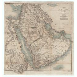
A Map of Arabia and Syria Laid Down Chiefly From Original Surveys Under the Superintendence of Lieut. Colonel Chesney, R.A.F.R.S. and drawn by W. H. Plate. L.L. D
This is one of the most significant and detailed maps of Arabia and the Persian Gulf. It is drawn by Plate using various sources. As stated below the cartouche the source...
Date: London, 1849
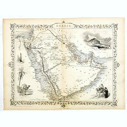
Arabia.
A highly decorative and detailed map of Arabia, drawn and engraved by J.Rapkin and the Illustrations by H. Warren after J. Rogers.Taken from "The illustrated atlas a...
Date: London / New York: John Tallis & co, c.1851

Europish Turkije, Griekenland Jonische Eilander.
Uncommon map of Greece, Lithography by J.H. van Weijer, published in Atlas der geheele Aarde in 24 kaarten. With colored key to processions.
- $10 / ≈ €9
Date: Groningen, ca. 1860
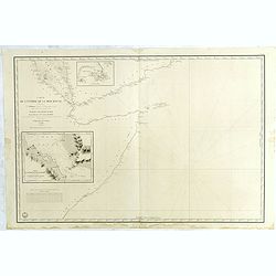
Arabia. Gulf of Aden - North Coast. Aden and Adjacent Bays..
Large chart focused east of Aden, in Yemen. With inset plan of Aden Anchorage in the upper right corner and a set of coastal profiles in the upper left corner.With latitu...
- $900 / ≈ €786
Date: London (1836) corrected to 1868
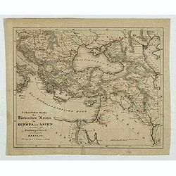
Karte des Türkischen Reiches in Europa und Asien . . .
Map of Turkish Empire.
- $35 / ≈ €31
Date: Breslau, 1878
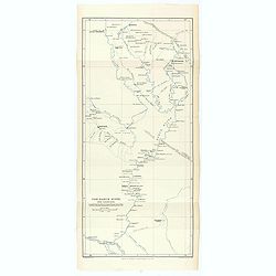
The Karun River and branches.
Karun River and branches map compiled from the charts of Colonel Chesney, Lieut. Selby and Captain Clements.The Karun continues toward the Persian Gulf, forking into two ...
Date: London, 1890

L'illustration, journal officiel hebdomadaire.
L'Illustration, the first French illustrated newspaper from 1843, became the first magazine in the world in 1906 and is distributed in more than 150 countries.The mythica...
Date: Paris, 1908
