Browse Listings in World Maps
![[Set of five maps] Carte Générale de la Terre ou Mappe Monde](/uploads/cache/41145X-250x250.jpg)
[Set of five maps] Carte Générale de la Terre ou Mappe Monde
Rare and decorative set of five wall maps of the world and the four continents, prepared by Clouet, in very fine bright contemporary coloring. Each map ca. 965 x 1230 mm ...
Place & Date: Paris and Cadiz, Mondhare, 1785-1793

Matching set of four wallmaps of America, Asia, America, Europe.
Rare and decorative set of four wall maps published by Louis Charles DESNOS ( fl.1750-1770), including a border with vignettes describing native scenes. Each panel is acc...
Place & Date: Paris, 1760-1761

Secunda etas mundi. Folium XIII.
Schedel's world map was based on the cartographic system of Claudius Ptolemy, the great second-century AD geographer whose scholarship formed the foundation for map produ...
Place & Date: Nuremberg, 12 July 1493
![[World and 4 continents] Carte Geographique Astronomique Chronologique et Historique du Monde.](/uploads/cache/63024-250x250.jpg)
[World and 4 continents] Carte Geographique Astronomique Chronologique et Historique du Monde.
French wall map of the world in 4 sheets published by Crépy "à l'entrée du Cloistre de St. Benoist du côté des maturins". A decorative wall map of the worl...
Place & Date: Paris, 1720-1735

Nouvelle et exacte description du globe terrestre reveue corrigée et augmente´e suivant les derniéres relations des Anglais et Hollandois. Par Guillaume Blaeu 1645.
Extremely rare and decorative "carte a figures" world map published by Anthoine de Fer. The double hemisphere world map is surrounded by constellations of the A...
Place & Date: Paris, 1645
![Shintei Bankoku Zenzu [Revised Comprehensive Map of All Countries]](/uploads/cache/48437-250x250.jpg)
Shintei Bankoku Zenzu [Revised Comprehensive Map of All Countries]
Compiled by Kageyasu Takahashi, the finest world map of the Edo period, copper plate print, 1810. Bunka 7 is dated from the preface on this map,This world map, published ...
- $26000 / ≈ €24329
Place & Date: Kyoto, Bunka 7 or 1810
![[Printed on silk] Nieuw Wassende Graaden Paskaart Vertoonende alle de bekende Zeekusten en Landen op den geheelen Aard Boodem of Werelt door Gerard van Keulen. . .](/uploads/cache/31640-250x250.jpg)
[Printed on silk] Nieuw Wassende Graaden Paskaart Vertoonende alle de bekende Zeekusten en Landen op den geheelen Aard Boodem of Werelt door Gerard van Keulen. . .
A very scarce and beautiful chart on Mercator's projection printed on silk. With the name of Gerard van Keulen and the privilege. The map shows great interior detail, inc...
Place & Date: Amsterdam, 1728

Le globe terrestre representé en deux plans-hemispheres, Dressé sur la Projection de Mr. De la Hyre...
“This splendid GlobeTerrestre originally published by J.B. Nolin is one of the finest large-scale world maps to be produced and is a fitting bridge between the geograph...
Place & Date: Paris, c. 1780

Nova et Accuratissima Totius Terrarum Orbis Tabula.
Since its appearance as an Appendix in 1630, the atlas launched by Willem Blaeu and continued by his son Joan had expanded greatly. But despite many new regional maps the...
Place & Date: Amsterdam, 1662

Nansenbushu bankoku shoka no zu.
This map is a great example of Japanese world maps representing Buddhist cosmology with real-world cartography. It is the earliest one and - therefore - the prototype for...
Place & Date: Kyoto, (Hoei 7 = Year of the Tiger) 1710

Nova Totius Terrarum Orbis Geographica..
The first of four states of the map. French text on verso. One of the most beautiful world maps ever engraved and one of the most influential in promulgating the Californ...
Place & Date: Amsterdam, 1630-1633

Orbis Terrae Compendiosa Descriptio.
Gerard Mercator's great world map of 1569 was condensed into double hemispherical form by his son Rumold. It first appeared in 1587 in Casaubon's edition of Strabo's Geog...
Place & Date: Amsterdam, 1595-1609

A new and correct map of the world.
The early eighteen century was one of the most important periods for English cartography. One of the period's most intriguing world maps is this large scale map which off...
- $12000 / ≈ €11229
Place & Date: London 1714

Nova Totius Terrarum Orbis Geographica ac Hydrographica Tabula.
A beautifully decorative world map taken from the 'English Atlas' by Moses Pitt and Steven Swart, based on an earlier engraved world map by Pieter van den Keere ca. 1630,...
Place & Date: Oxford, 1680

Nova Orbis Tabula in Lucem edita A.F.de Wit.
According to Shirley, De Wit's map is one of the most attractive of its time. The brilliant scenes in the corners combine images of the four seasons, the elements, and th...
Place & Date: Amsterdam, 1680
Cosmographie, ou description des quatre parties du Monde...
Fourth French edition (first French collective edition), considerably enlarged with the double-page truncated cordiform world map "Charte cosmographique", in us...
Place & Date: Antwerp, Jean Bellere, a l'Aigle d'Or, 1581

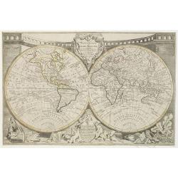
Nouvelle Mappa Monde.
State 2 of this fine double hemisphere world map, from an unusual perspective, with a "Mer de L'Ouest" or "Sea of the West". Paris is located at the c...
Place & Date: Venice, 1776 - 1784
![[Ritter Sundial Map of the World]](/uploads/cache/60731-250x250.jpg)
[Ritter Sundial Map of the World]
This highly unusual map projects the world from the north pole as though it were the table of a sundial, with the land masses drawn to scale in proportion to their distan...
- $4500 / ≈ €4211
Place & Date: Nuremberg, 1640

Carte de la Charte de L'Antique . . .
The rare French version of this decorative pictorial world map by MacDonald Gill. "This magnificent map drawn up while the Second World War still raged is already en...
Place & Date: London, Alf Cooke Ltd, 1943
![[Il mondo a pezzi - Europa].](/uploads/cache/42849-250x250.jpg)
[Il mondo a pezzi - Europa].
Satirical representation of the division of the world by the main European powers. At the center of the scene a globe on which is written "MONDO Maledeto Interesse ...
Place & Date: Bologna, 1690

AIR France - Le plus grand réseau du monde.
Created in 1959 by the artist Lucien Boucher, showing all of the DC-7 Air France Routes. The Blue Pink Poster is one of a series of eight posters commissioned by Air Fran...
Place & Date: Imprimerie Perceval, Paris, 1959

(World map). Americus Vespucio novo te Duce Ducta Freto Ambivi Meritoqs Vocor.
Manuscript world map showing the American and African continent and the southern parts of Asia. In the Indian Ocean a large depiction of Amerigo Vespucci 1454 – 1512) o...
Place & Date: Italy, ca. 1954

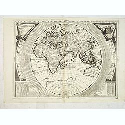
Hemisphaerium Orbis Antiqui cumzonis circulis. . .
A chart showing the eastern hemisphere, including north eastern coast of Australia with, superimposed, climatic zones and planetary details. Surround by most decorative s...
Place & Date: Amsterdam, 1708
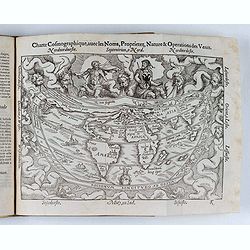
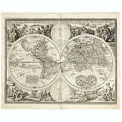
Mappemonde ou globe terestre dressée sur les Nouvelles Observations . . .
Scarce world map with all the major early explorers. Jean Baptiste Louis Clouet (born 1730) was a member of the Academie Royale des Sciences de Rouen and the author of Ge...
Place & Date: Paris, Mondhare, 1787
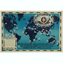
British Empire Trade Map WWII Eric Fraser.
Original vintage World War Two period British Empire trade map poster with the stylised text in Spanish reading: For more than two centuries the British fleets have kept ...
Place & Date: England, 1941
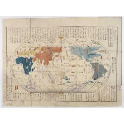
Chikyu Bankoku sankai yochi zenzu setsu. / Sekisui Cho Harutaka. (Map and description of geography of all the countries of the globe).
Reduced version of the famous map "Kaisei chikyu bankoku zenzu" by Sekisui Nagakubo (1717-1801) published ca. 1785, still based on the one by Matteo Ricci. Incl...
- $3500 / ≈ €3275
Place & Date: Tokyo, 1850

World Flight Routes (all in Japanese).
A large very decorative Japanese world map published as sugoroku (a Japanese game which might be compared to backgammon) published as a supplement to the 1930 New Year’...
Place & Date: Osaka, 1930
![[No title - Daniel's Dream map]](/uploads/cache/34784-250x250.jpg)
[No title - Daniel's Dream map]
Wood block print engraved by the famous engravers Jost Amman and Virgil Solis - with their initials in lower bottom of the map. This somewhat curious map of Europe, Afric...
Place & Date: Cologne, ca. 1564

The Pathways of Empire Delineated: Map Showing The Steam Comunication And Overland Routes between England, India, China & Australia…
An illuminating and attractive map that illustrates one of the foundations of British imperial power--the key trade routes by both land and sea between England and its fa...
- $3000 / ≈ €2807
Place & Date: London, 1856
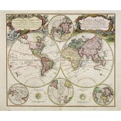
Planiglobii Terrestris - Mappe-Monde...
Word map in double hemisphere. In center two smaller hemispheres of the north and south pole are shown. Two interesting diagrams depict the earth as it would be seen from...
Place & Date: Nuremberg, 1746
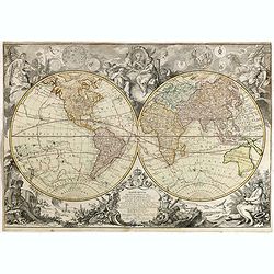
Mappemonde Dressée sur les Relations les Plus Nouvelles et les plus approuvées assujeties aux Obserations de Mrs. De L'Académie Royale des Sciences.
Dated 1761, this state is unknown. "Desnos' includes a fine combination of up to date cartographic information and the routes of important 18th century voyages of ex...
- $3000 / ≈ €2807
Place & Date: Paris, 1789
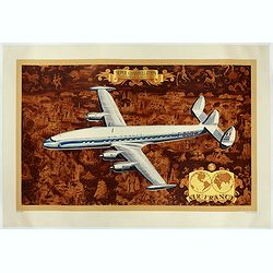
AIR France - Super constellation, Lockhead L - 10 - 49.
Promotional poster attributed to Lucien Boucher showing of a Lockhead L - 10 - 49 on a Mercator projection world map. The map depicts a pictorial map of the entire world ...
Place & Date: Perceval, Paris, 1953
![[No title] 'Daniel's Dream Map' or 'Wittenberg World Map'.](/uploads/cache/34785-250x250.jpg)
[No title] 'Daniel's Dream Map' or 'Wittenberg World Map'.
Wood block print engraved by the famous engravers Jost Amman and Virgil Solis - with their initials in lower bottom of the map. This somewhat curious map of Europe, Afric...
Place & Date: Cologne, ca. 1564
Planisfero del Mondo Vecchio. . .
A decorative map of the Eastern hemisphere includes Abel Tasman's discoveries in Australia. The decorative borders include coordinates and descriptions of signs of the zo...
Place & Date: Venice, 1691
Selling price: $1800
Sold in 2015
Orbis terrarum typus de integro in plurimis emendatus auctus et icunculis illustratus.
Outstanding and rare example of a bible world map based on the Visscher bible map from 1657 (Shirley 401/414). This map is larger in size and has an extra engraved frame ...
- $2000 / ≈ €1871
Place & Date: Minden, 1729
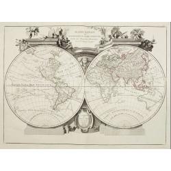
Mappa Monde ou description du globe terrestre . . .
Double hemisphere world map. California is not an island anymore, but a large Mer de l'Ouest is shown. Delineation between New Holland (Australia) and New Guinea is not y...
- $2200 / ≈ €2059
Place & Date: Venice, 1776 - 1784
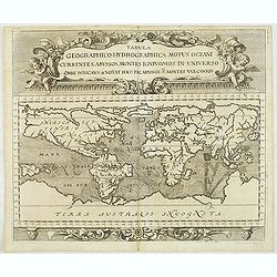
Tabula geographico-hydrographica motus Tom II p.132.
World map depicting ocean currents, volcanoes and deep-sea chasms. The continents are void of political detail and only major lakes, rivers and volcanoes are shown. There...
- $2000 / ≈ €1871
Place & Date: Nuremberg, 1696
Descrizione del Globo in due emisferi . . .
This large-format map is finely engraved and beautifully colored and was prepared by Girolamo Petri, a lawyer who served as a senior official within the Vatican’s State...
- $1750 / ≈ €1638
Place & Date: Rome, 1858
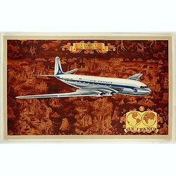
AIR France - Comet De Havilland
Promotional poster attributed to Lucien Boucher showing the Comet de Havilland on a Mercator projection world map. The map depicts a pictorial map of the entire world in ...
- $1600 / ≈ €1497
Place & Date: Perceval, Paris, 1953
![[Horological diagrams surrounding a smaller world map]](/uploads/cache/45027-250x250.jpg)
[Horological diagrams surrounding a smaller world map]
This beautiful engraving has nine (of ten) horological diagrams surrounding a smaller map, which omits any delineation of the British Isles. Projected from the North Pole...
- $2000 / ≈ €1871
Place & Date: Nuremberg 1640