Browse Listings in World Maps

Secunda etas mundi. Folium XIII.
Schedel's world map was based on the cartographic system of Claudius Ptolemy, the great second-century AD geographer whose scholarship formed the foundation for map produ...
Place & Date: Nuremberg, 12 July 1493
![[No title - Daniel's Dream map]](/uploads/cache/34784-250x250.jpg)
[No title - Daniel's Dream map]
Wood block print engraved by the famous engravers Jost Amman and Virgil Solis - with their initials in lower bottom of the map. This somewhat curious map of Europe, Afric...
Place & Date: Cologne, ca. 1564
![[No title] 'Daniel's Dream Map' or 'Wittenberg World Map'.](/uploads/cache/34785-250x250.jpg)
[No title] 'Daniel's Dream Map' or 'Wittenberg World Map'.
Wood block print engraved by the famous engravers Jost Amman and Virgil Solis - with their initials in lower bottom of the map. This somewhat curious map of Europe, Afric...
Place & Date: Cologne, ca. 1564
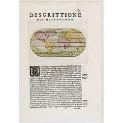
Descittione del Mappamondo.
A fine miniature oval map of the world engraved by Girolamo Porro. It is a reduction of Giovanni Francesco Camocio's superb large map of 1567, one of the last in the long...
- $450 / ≈ €421
Place & Date: Venice, ca.1586
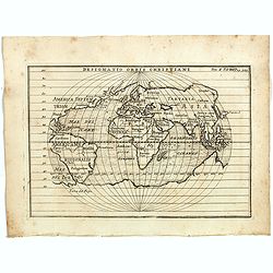
Designatio Orbis Christiani
Planispherical world map broadly based on Ortelius and similar to Hondius's Atlas Minor map of the same title. It shows most of the world, excluding the west coast of Nor...
- $450 / ≈ €421
Place & Date: France, ca 1607
![[Titlepage] Nomenclator Ptolemaicus..](/uploads/cache/06436-250x250.jpg)
[Titlepage] Nomenclator Ptolemaicus..
Title page from a Ortelius Atlas part called: Nomenclator , containing a register of place names in antiquity. Letterpress with copper engraved print (60x60mm) of the eas...
- $150 / ≈ €140
Place & Date: Antwerp, 1609

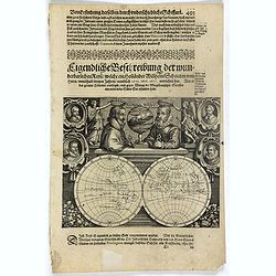
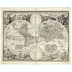
Orbis Terrae Compendiosa Descriptio.
Gerard Mercator's great world map of 1569 was condensed into double hemispherical form by his son Rumold. It first appeared in 1587 in Casaubon's edition of Strabo's Geog...
Place & Date: Amsterdam, 1595-1609
![Summa philosophiae quadripartita, de rebus dialecticis, moralibus et metaphysicis . . [ With unrecorded world map ]](/uploads/cache/28639-250x250.jpg)
Summa philosophiae quadripartita, de rebus dialecticis, moralibus et metaphysicis . . [ With unrecorded world map ]
On page 107 a finely copper engraved world map (88x84mm.) Paradigma Terrae Plagas 4.ac 12. Ventorum situm indicans., centered on Europe and Africa, with parts of America,...
Place & Date: Leiden, Peter Rigaud, 1626
Description de nouveau pasage vers le zud.... together with an untitled map of Port Desire (today's Puerto Deseado, Argentina)
Rare double hemispherical world map showing the track round the world by Le Maire and Schouten in 1615-1617. Continents are marked in outline and no southern regions are ...
- $1500 / ≈ €1404
Place & Date: Frankfurt, M.Merian, 1631

Nova Totius Terrarum Orbis Geographica..
The first of four states of the map. French text on verso. One of the most beautiful world maps ever engraved and one of the most influential in promulgating the Californ...
Place & Date: Amsterdam, 1630-1633
![[Horological diagrams surrounding a smaller world map]](/uploads/cache/45027-250x250.jpg)
[Horological diagrams surrounding a smaller world map]
This beautiful engraving has nine (of ten) horological diagrams surrounding a smaller map, which omits any delineation of the British Isles. Projected from the North Pole...
- $2000 / ≈ €1871
Place & Date: Nuremberg 1640
![[Ritter Sundial Map of the World]](/uploads/cache/60731-250x250.jpg)
[Ritter Sundial Map of the World]
This highly unusual map projects the world from the north pole as though it were the table of a sundial, with the land masses drawn to scale in proportion to their distan...
- $4500 / ≈ €4211
Place & Date: Nuremberg, 1640

Nouvelle et exacte description du globe terrestre reveue corrigée et augmente´e suivant les derniéres relations des Anglais et Hollandois. Par Guillaume Blaeu 1645.
Extremely rare and decorative "carte a figures" world map published by Anthoine de Fer. The double hemisphere world map is surrounded by constellations of the A...
Place & Date: Paris, 1645
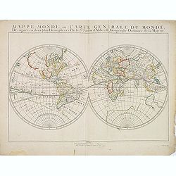
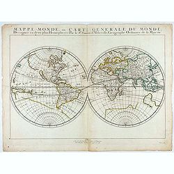
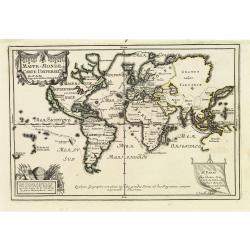
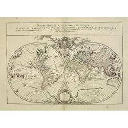
Mappe-Monde, ou Carte Generale du Monde: Dessignée en deux plans Hemispheres Par le Sr. Sanson d'Abbeville, Geographe ordinaire de sa Majesté.
Sanson's first world maps, dated 1651 and 1652, were issued separately and then in collections of mapsThe map is one of the first to distinguish the Great Lakes, all five...
Place & Date: Paris, 1651
Mappe-Monde, ou Carte Generale du Monde: Dessignée en deux plans Hemispheres Par le Sr. Sanson d'Abbeville, Geographe ordinaire de sa Majesté.
First state of Sanson's first map of the World. Sanson's first world maps, dated 1651 and 1652, were issued separately and then in collections of maps. The map is one of ...
- $1500 / ≈ €1404
Place & Date: Paris, 1651
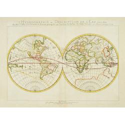
L'Hydrographie ..la Surface du Globe Terrestre.
An unusual double hemisphere hydrological map of the world - the earliest of the world prepared by the great French mapmaker Nicolas Sanson. Of particular interest is the...
- $750 / ≈ €702
Place & Date: Paris, 1652

Nova et Accuratissima Totius Terrarum Orbis Tabula.
Since its appearance as an Appendix in 1630, the atlas launched by Willem Blaeu and continued by his son Joan had expanded greatly. But despite many new regional maps the...
Place & Date: Amsterdam, 1662

Nova Orbis Tabula in Lucem edita A.F.de Wit.
According to Shirley, De Wit's map is one of the most attractive of its time. The brilliant scenes in the corners combine images of the four seasons, the elements, and th...
Place & Date: Amsterdam, 1680

Nova Totius Terrarum Orbis Geographica ac Hydrographica Tabula.
A beautifully decorative world map taken from the 'English Atlas' by Moses Pitt and Steven Swart, based on an earlier engraved world map by Pieter van den Keere ca. 1630,...
Place & Date: Oxford, 1680
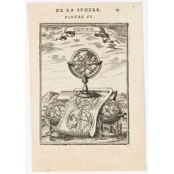
Equateur.
Appealing print centered on an armillary sphere. The latter sits atop a map of the world which clearly shows California as an island. In addition to this curious feature,...
- $200 / ≈ €187
Place & Date: Paris, 1683
![[Il mondo a pezzi - Europa].](/uploads/cache/42849-250x250.jpg)
[Il mondo a pezzi - Europa].
Satirical representation of the division of the world by the main European powers. At the center of the scene a globe on which is written "MONDO Maledeto Interesse ...
Place & Date: Bologna, 1690
Planisfero del Mondo Vecchio. . .
A decorative map of the Eastern hemisphere includes Abel Tasman's discoveries in Australia. The decorative borders include coordinates and descriptions of signs of the zo...
Place & Date: Venice, 1691
Selling price: $1800
Sold in 2015
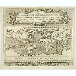
Tabula geographico-hydrographica motus Tom II p.132.
World map depicting ocean currents, volcanoes and deep-sea chasms. The continents are void of political detail and only major lakes, rivers and volcanoes are shown. There...
- $2000 / ≈ €1871
Place & Date: Nuremberg, 1696
Mappe-Monde ou carte Universelle. . .
Uncommon world map in Mercator's projection, which first appeared in De Fer's Atlas Curieux.Showing California as an island. Engraved by C.Inselin.Shows the explorer's ro...
Place & Date: Paris, 1705

Hemisphaerium Orbis Antiqui cumzonis circulis. . .
A chart showing the eastern hemisphere, including north eastern coast of Australia with, superimposed, climatic zones and planetary details. Surround by most decorative s...
Place & Date: Amsterdam, 1708

Nansenbushu bankoku shoka no zu.
This map is a great example of Japanese world maps representing Buddhist cosmology with real-world cartography. It is the earliest one and - therefore - the prototype for...
Place & Date: Kyoto, (Hoei 7 = Year of the Tiger) 1710
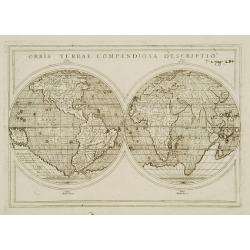
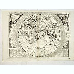
Orbis Terrae compendiosa descriptio.
Modern world map by Rosaccio, consisting of two hemispheres enclosed within a plain border. The engraving is sharp and neat, and is a skilful reduction of Rumold Mercator...
- $1000 / ≈ €936
Place & Date: Venise, 1598/1713

A new and correct map of the world.
The early eighteen century was one of the most important periods for English cartography. One of the period's most intriguing world maps is this large scale map which off...
- $12000 / ≈ €11229
Place & Date: London 1714
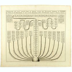
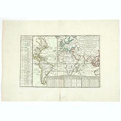
Succession des plus anciens Rois du monde . . .
Showing successions of the oldest kings of the world, with a globe in lower part of the print. Copper engraved plate from "Atlas Historique". Zacharie Chatelain...
- $45 / ≈ €42
Place & Date: Amsterdam, 1720
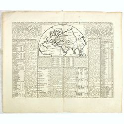
Carte pour servir à l'intelligence de l'histoire de la chronologie et de la géographie des empires des Assiriens, des Perses, des Egyptiens et des Chinois.
Interesting sheet with a map of the classical world showing the empires of the Assyrians, Persians, Egyptians and Chinese, with descriptive French text, from Chatelain's ...
Place & Date: Amsterdam, 1720
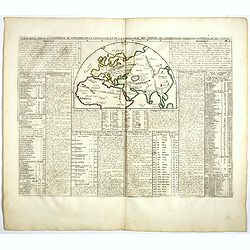
Carte pour servir à l'intelligence de l'histoire de la chronologie et de la géographie des empires des Assiriens, des Perses, des Egyptiens et des Chinois.
Interesting sheet with a map of the classical world showing the empires of the Assyrians, Persians, Egyptians and Chinese, with descriptive French text, from Chatelain's ...
- $75 / ≈ €70
Place & Date: Amsterdam, 1720
Carta Hydrographica oder Algemeine Welt. . .
World map in Mercator projection. Showing California as an island. In the upper left and right-hand corner two ships. The map is showing the important trade routes.
Place & Date: Augsburg, 1720
![[Printed on silk] Nieuw Wassende Graaden Paskaart Vertoonende alle de bekende Zeekusten en Landen op den geheelen Aard Boodem of Werelt door Gerard van Keulen. . .](/uploads/cache/31640-250x250.jpg)
[Printed on silk] Nieuw Wassende Graaden Paskaart Vertoonende alle de bekende Zeekusten en Landen op den geheelen Aard Boodem of Werelt door Gerard van Keulen. . .
A very scarce and beautiful chart on Mercator's projection printed on silk. With the name of Gerard van Keulen and the privilege. The map shows great interior detail, inc...
Place & Date: Amsterdam, 1728
Mappe-Monde pour connoitre les progres & les conquestes..
Unusual double hemisphere map with California as an Island. Dutch text describes the expeditions and colonial possessions of the Dutch East India Company. The map origina...
Place & Date: Amsterdam, 1729
Orbis terrarum typus de integro in plurimis emendatus auctus et icunculis illustratus.
Outstanding and rare example of a bible world map based on the Visscher bible map from 1657 (Shirley 401/414). This map is larger in size and has an extra engraved frame ...
- $2000 / ≈ €1871
Place & Date: Minden, 1729
![[World and 4 continents] Carte Geographique Astronomique Chronologique et Historique du Monde.](/uploads/cache/63024-250x250.jpg)
[World and 4 continents] Carte Geographique Astronomique Chronologique et Historique du Monde.
French wall map of the world in 4 sheets published by Crépy "à l'entrée du Cloistre de St. Benoist du côté des maturins". A decorative wall map of the worl...
Place & Date: Paris, 1720-1735
Mappe-Monde Geo-Hydrographique, ou Description Générale. . .
Large map of the world in two hemispheres, in a stereographic projection (each hemisphere 31.5 cm in diameter). California seems to be connected to the mainland, rather t...
Place & Date: Paris, 1719, but ca. 1741-1745
Carte des lieux où les différentes longueurs du pendule à secondes ont été observées . . .
World map. Published in Buache's "Considérations géographiques et physiques", one of his most important and original cartographic works.The map projects the c...
- $500 / ≈ €468
Place & Date: Paris, 1746
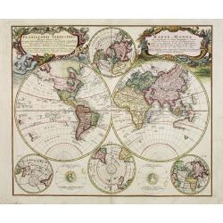
Planiglobii Terrestris - Mappe-Monde...
Word map in double hemisphere. In center two smaller hemispheres of the north and south pole are shown. Two interesting diagrams depict the earth as it would be seen from...
Place & Date: Nuremberg, 1746
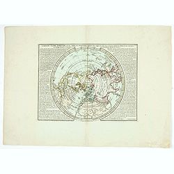
Carte du globe terrestre où les terres de l'hémisphère méridl sont supposées être vues à travers celles de l'hémisphère septentl.
Important single hemisphere world map prepared by Buache's with Sea of the West. Published in Buache's "Considérations géographiques et physiques", one of his...
- $500 / ≈ €468
Place & Date: Paris, 1746