Browse Listings in World Maps
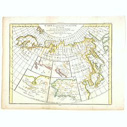
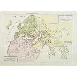
Carte des parties Nord et Est de L'Asie. . .
Five maps on one sheet, showing the Northern Russian territories in Europe and Asia, including the western coastline from Siberia, with Japan and Korea with the island of...
- $100 / ≈ €94
Place & Date: Paris, 1779
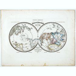
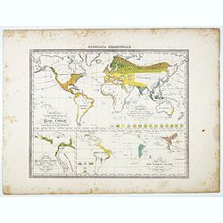
Mappamondo Carta d'Insieme.
Uncommon double hemisphere pole projection prepared by Francesco Costantino Marmocchi. Above the map "Geografia Commerciale". With a color code underneath the m...
Place & Date: Genova, Paolo Rivara fu Giacomo, 1858
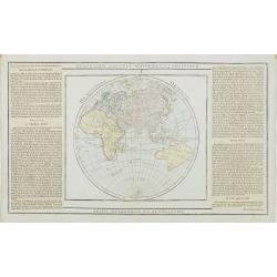
Hémisphère Oriental..
Map of the Eastern Hemisphere, including numerous exploration routes with a notation of important recent discoveries.Australia is partially mapped and then completed into...
- $150 / ≈ €140
Place & Date: Paris, 1786
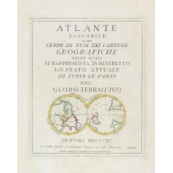
(Title page) Mappamondo sul Piano dell' Equatore. - Atlante Tascabile o sia Serie di Num. XXI Cartine Geografiche nelle quali si. . .
Engraved title page with in lower part a double polar projection (50x95mm.) from the rare atlas Atlante Tascabile o sia Serie di Num. XXI Cartine Geografiche nelle quali ...
- $100 / ≈ €94
Place & Date: Rome, 1823
![[No Tittle] Map of the Easteren Hemisphere.](/uploads/cache/29385-250x250.jpg)
[No Tittle] Map of the Easteren Hemisphere.
Nice small map of eastern hemisphere by Johannes Walch in his rare Allgemeiner Atlas Nach den bewährsten Hülfsmitteln und astronomischen Ortsbestimungen…, edition of ...
- $120 / ≈ €112
Place & Date: Augsburg, 1812
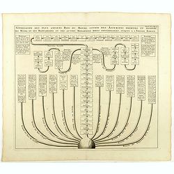
Carte pour servir à l'intelligence de l'histoire de la chronologie et de la géographie des empires des Assiriens, des Perses, des Egyptiens et des Chinois.
Interesting sheet with a map of the classical world showing the empires of the Assyrians, Persians, Egyptians and Chinese, with descriptive French text, from Chatelain's ...
- $75 / ≈ €70
Place & Date: Amsterdam, 1720
![[World map with oceanic currents].](/uploads/cache/46149-250x250.jpg)
[World map with oceanic currents].
Alexey Afinogenovich Ilyin was a lieutenant general and cartographer (1832-1889). In 1856, after graduating from the Academy of the General Staff, he was at the military ...
- $100 / ≈ €94
Place & Date: St. Petersburg, 1899
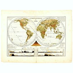
Hypsometrisch Overzicht der Aarde.
One of the earliest thematic world maps published in the Netherlands from "Atlas der natuurkundige aardrijkskunde. . .". prepared by Nicolaas Wilhelmus Posthumu...
- $50 / ≈ €47
Place & Date: Amsterdam, C.L. Brinkman, 1883
Il mondo cocsciuto dagli antichi e le laggiori antiche monarchie Persiana, Macedone, Romana . . .
A rare double-page map of the Ancient World. From l'Atlante Storico, Letterario, Biografico, Archeologico. . . with attributions by Giambatista Albrizzi.Lower left a col...
Place & Date: Venice, 1840
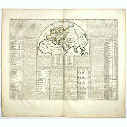
Succession des plus anciens Rois du monde . . .
Showing successions of the oldest kings of the world, with a globe in lower part of the print. Copper engraved plate from "Atlas Historique". Zacharie Chatelain...
- $45 / ≈ €42
Place & Date: Amsterdam, 1720
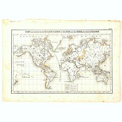
Kaart, voorstellende de Seculaire Rijzingen en Dalingen van den Bodem, alsmede de Vulkamen.
One of the earliest thematic world maps published in the Netherlands from "Atlas der natuurkundige aardrijkskunde. . .". prepared by Nicolaas Wilhelmus Posthumu...
- $35 / ≈ €33
Place & Date: Amsterdam, C.L. Brinkman, 1883
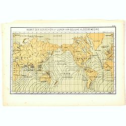
Kaart der Isorachiën of Lijnen van Gelijke Vloedbeweging.
One of the earliest thematic world maps published in the Netherlands from "Atlas der natuurkundige aardrijkskunde. . .". prepared by Nicolaas Wilhelmus Posthumu...
- $35 / ≈ €33
Place & Date: Amsterdam, C.L. Brinkman, 1883
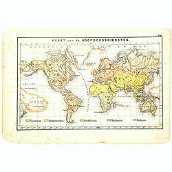
Kaart van de Hoofdgodsdiensten.
One of the earliest thematic world maps published in the Netherlands from "Atlas der natuurkundige aardrijkskunde. . .". prepared by Nicolaas Wilhelmus Posthumu...
- $35 / ≈ €33
Place & Date: Amsterdam, C.L. Brinkman, 1883
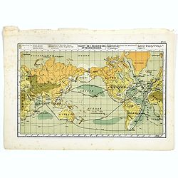
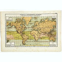
Kaart der Oceanische Stroomgebieden.
One of the earliest thematic maps published in the Netherlands from "Atlas der natuurkundige aardrijkskunde. . .". prepared by Nicolaas Wilhelmus Posthumus. The...
- $35 / ≈ €33
Place & Date: Amsterdam, C.L. Brinkman, 1883
Kaart der Oceanische Stroomgebieden.
One of the earliest thematic maps published in the Netherlands from "Atlas der natuurkundige aardrijkskunde. . .". prepared by Nicolaas Wilhelmus Posthumus. The...
- $35 / ≈ €33
Place & Date: Amsterdam, C.L. Brinkman, 1883
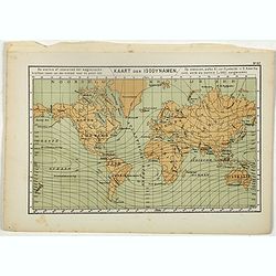
Kaart der Isodynamen.
One of the earliest thematic maps published in the Netherlands from "Atlas der natuurkundige aardrijkskunde. . .". prepared by Nicolaas Wilhelmus Posthumus. The...
- $35 / ≈ €33
Place & Date: Amsterdam, C.L. Brinkman, 1883
Distribuzione geografica delle Pianta coltivate . . .
Uncommon world map in Mercator projection representing food resources on 3 inset maps, prepared by Francesco Costantino Marmocchi. Above the map "Geografia Commercia...
Place & Date: Genova, Paolo Rivara fu Giacomo, 1858