Browse Listings
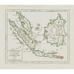
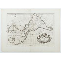
Les Isles de la Sonde.
Small detailed map of southeast Asia, showing the Malay Peninsula, Sumatra, Java and the island of Borneo. Dated 1769.From Atlas Portatif Universel, by Robert de Vaugondy...
- $200 / ≈ €174
Date: Paris, later than 1769
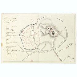
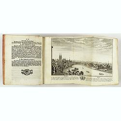
![[manuscript plan] Siège de Schweidnitz en Silésie fait par les trouppes Imperial es commandées par Mr. le de Nadasti ...](/uploads/cache/39893-250x250.jpg)
[manuscript plan] Siège de Schweidnitz en Silésie fait par les trouppes Imperial es commandées par Mr. le de Nadasti ...
This fine manuscript shows the layout of the city of Swidnica with its surrounding defence wall, its advanced bastions and suburbs, roads and two nearby villages. In lowe...
- $2750 / ≈ €2386
Date: France, 1769

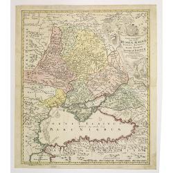
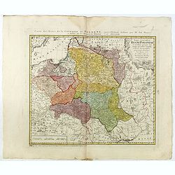
Nouveau théâtre de la guerre entre les Russes les turcs et les polonois confédérés.
A very rare separately published map of Crime region. With a large title cartouche lower left "Nouveau theâtre de la guerre entre les russes, les turcs et les polon...
Date: Paris, 1769

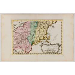
Nieuwe Kaart van de Grootbrittannische Volkplantingen in Noord America waar in Tevens de Fransche Bezittingen en de Landen tuschen die Beide Volken. . .
A map of the east-coast of America from New Foundland till Florida, divided in French and British properties. Reduced size Dutch edition of Mitchell's map of North Americ...
Date: Amsterdam, 1769

Nieuwe kaart van Kanada . . .
Nice map of the Bay of Hudson, In Labrador, a small inset of Nova Scotia. The map is dated 1769. All text is in Dutch. The map shows the region shortly after the conclusi...
Date: Amsterdam, 1769
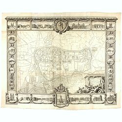
Plan général de Reims et de ses Environs Dédié au Roi.
Rare wall map of a plan of Reims engraved by Jean Lattré. Central cartouche included in the lower border, composed of the coat of arms of France and Navarre, surmounted ...
- $2500 / ≈ €2169
Date: Paris, Lattré, 1769
Plan de Thiagar, prise par l'arméé française en 1759.
An early manuscript map of Thiagar. With an extensive unfinished key to the left. The map was drawn shortly after the end of the Seven Years War, when the French took pos...
- $750 / ≈ €651
Date: Paris, 1769
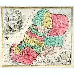
Terra Sancta sive Palaestina. . .
Map of Palestine divided among the Tribes on both sides of Jordan and into Kingdoms of Judah and Israel. Cartouche at bottom right features a small map of the Exodus.T.C....
- $750 / ≈ €651
Date: Augsbourg, 1770

Vue des Promenades et les Fontaines d'Ispahan.
Carmine was a well-known publisher of optical prints, established in Augsburg.Isfahan was once one of Central Asia's largest and most important cities, at the crossroads ...
Date: Augsburg 1770

Plan der Stadt Quebec Haupstadt in Neu Franckreich oder Canada.
Town-plan of Quebec, with an inset view of the town in the lower right corner. In the upper right a recapitulation of the main military actions prior to the surrender of ...
Date: Nurnberg, 1770
Tabula Geographica qua pars Russiae Magnae. . .
An unrecorded state Homann's map is based upon the works of George von Mengden (1628-1702), a Livonian cartographer who worked for Peter the Great and Count Jacob Bruce [...
Date: Nuremberg, c. 1770

(Berlin) Prospectus Armamentarii regnii versus arcem principis regis haereditarii Berolini.
A square in Berlin. In the eighteenth and nineteenth centuries there were many popular speciality establishments in Paris, Augsburg and London which produced optical view...
- $200 / ≈ €174
Date: Italy, 1770
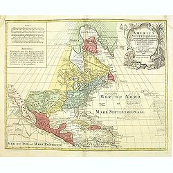
America Septentrionalis, Concinnata juxta Observationes..
This exemplar represents Lotter's version of Delisle's foundation map of North America, published in 1700. The Great Lakes show the French strong holds at Quebec, Montrea...
- $875 / ≈ €759
Date: Augsburg, ca. 1770
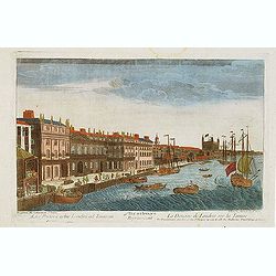
Vue d'optique representant La Douane de Londres sur la Tamise. . .
Showing the Customs office in London seen from the River Thames. Published by Daumont, who was a well-known publisher of optical prints, established in rue St. Jacques in...
- $200 / ≈ €174
Date: Paris, ca. 1770

Elevation perspective de la nouvelle place de Petersbourg suivant le projet . . .
Showing a perspective view of the new Palace Square in St. Petersburg. In the 1760s, the Baroque architecture was succeeded by neoclassical architecture.This so-called op...
- $200 / ≈ €174
Date: Paris, ca. 1770
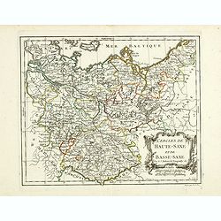
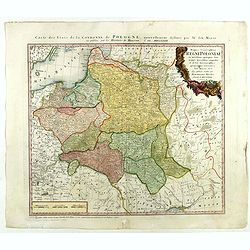
Cercles de Haute-Saxe et de Basse-Saxe.
Early edition of this fine map of the duchies of Saxony (upper & lower), including part of present-day Poland. Published in "Atlas Portatif de Vaugondy".Cha...
- $75 / ≈ €65
Date: Paris, ca.1770
(Hof, Voraths-Magazin, am Fontanka Flus, Zu Petersburg.)
So-called optical print illustrating a perspective view of the river Fontanka in Saint Petersburg. The Fontanka is a branch of the Neva river. At the right of the print w...
- $225 / ≈ €195
Date: Augsburg, c.1770
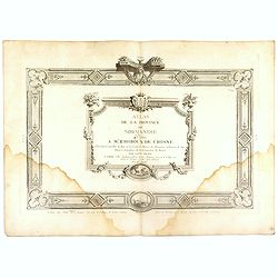
(Title page) Atlas de la Province de Normandie dédié à Mr Thiroux de Crosne . . .
Title page to a rare atlas of the province of Normandy "Atlas de la Province de Normandie dédié à Mr Thiroux de Crosne . . ." dedicated to Mr. Thiroux Crosne...
Date: Paris, ca. 1770

Almanach géographique ou petit atlas élémentaire composé de Cartes générales et particulières des différens Empires, Royaumes et Républiques de l'Europe. . .
Charming almanac with two engraved dedication and title page, portrait of Christian VII. Roy de Dannemarck et de Norvège.The map of Asia is of interest for the use of Ko...
- $3000 / ≈ €2603
Date: Paris, 1770
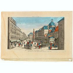
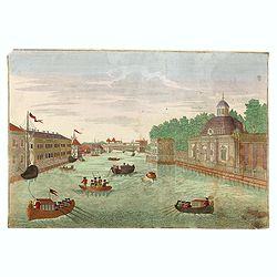
Vue et Perspective de la Trinité a Vienne.
Decorative perspective view of a square in Vienna centered on the column which represents the Trinity. Published by Jacques François Chereau [1742 -1794], who was active...
- $100 / ≈ €87
Date: Paris, 1770
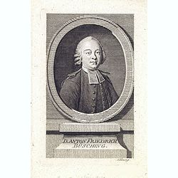
Danton Fridrich Büsching.
Copper engraved portrait of the geographer Anton Friedrich Büsching (1724–1793), engraved by Johann David Schleuen ( (active 1740-1774). Büsching was a celebrated Ger...
- $200 / ≈ €174
Date: Hamburg, ca. 1770
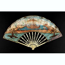
A folding fan showing a nautical festival, ca. 1770.
Folded fan, painted in gouache a ship pulled by two horses. On board, a large company, among others joins them while fishermen watch the scene.Reverse painted with an exo...
- $1500 / ≈ €1302
Date: France, ca. 1770
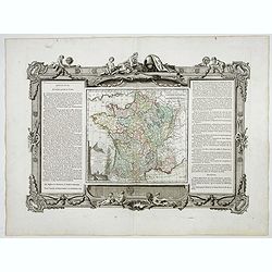
La France Divisée en ses quarante gouvernemens . . .
Map of France surrounded by a decorative frame.
Date: Paris, 1770
![Almanach Géograhique ou petit atlas.. [Seconde partie]](/uploads/cache/48945-250x250.jpg)
Almanach Géograhique ou petit atlas.. [Seconde partie]
The second part of this uncommon miniature atlas with extensive geographical descriptions of mainly European countries.Including map of France; Netherlands; Belgium; Spai...
Date: Paris, 1770
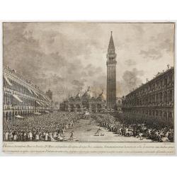
Habita a Serenissimo Duce in Basilica D.Marci ad populum allocutione…
Habita a Serenissimo Duce in Basilica D.Marci ad populum allocutione, ab eoque Dux salutatus, Armamentariorum humeris in sella gestatoria cum duobus proxime consanguineis...
Date: Venice, c. 1766-1770
America Septentrionalis et Meridionalis. T. XXXV.
Uncommon map in the style of Coronelli of the Western hemisphere. Map of America depicted as an elongated figure, oriented with North to West.This map is most notable for...
Date: Italy c. 1770

Réjouissances du Peuple près de la Pyramide d'Illumination, élévée sur l'Esplanade de la Porte de Mars et Distribution de Vivres, fontaines de Vin , sous les Ordres de Mrs. Du Conseil de la Ville, à Reims le 27 Aoust 1765.
Engraved by Varin after Moreau Jr. The print shows a lightning spectacle held in Reims on 27 August 1765.
Date: Paris, 1771
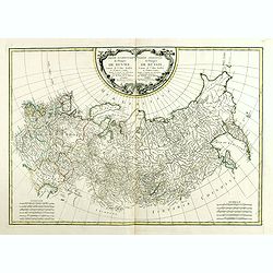
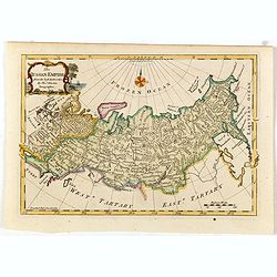
Partie Occidentale de l'Empire de Russie. . . / Partie Orientale de l'Empire de Russie. .
Attractive map of Russia, ornated with a rococo title cartouche. Boundaries outlined in hand color.The detailed map covers from the Baltic Sea to Siberia and the Bering S...
- $400 / ≈ €347
Date: Paris, ca 1771
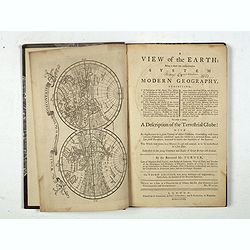
A view of the earth : being a short but comprehensive system of modern geography graphy ...
The Third Edition. First work with seven engraved maps (including a twin-hemisphere world map, continents), plate of a globe, engraved illustrations in the text including...
Date: London, S. Crowder and S. Gamidge, 1771
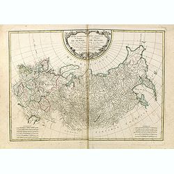
Partie Occidentale de l'Empire de Russie. . . / Partie Orientale de l'Empire de Russie. .
Attractive map of Russia, ornated with a rococo title cartouche. Boundaries outlined in hand color.The detailed map covers from the Baltic Sea to Siberia and the Bering S...
- $200 / ≈ €174
Date: Paris, ca 1771
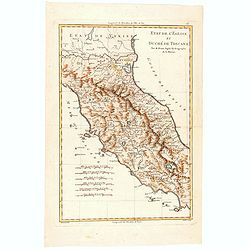
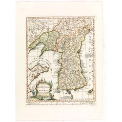
Etat de l'Eglise et Duché de Toscane.
Map of central Italy with Tuscany region by Rigobert Bonne.
- $75 / ≈ €65
Date: Paris, 1771
Royaume de hongrie et Pays Adjacents.
Map of the Northern part of the Kingdom of Naples, by Rigobert Bonne.
- $50 / ≈ €43
Date: Paris, 1771
![[Title page] Atlas moderne ou collection de cartes. . .](/uploads/cache/47740-250x250.jpg)
[Title page] Atlas moderne ou collection de cartes. . .
Title page of Atlas moderne ou collection de cartes by Bonne Rigobert in 1771, published by Lattré, frontispiece drawn by Mounet and engraved by Prevost.
- $150 / ≈ €130
Date: Paris, 1771
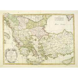
Turquie d'Europe et partie de celle d'Asie…
An attractive map of Turkey, Greece, Cyprus. Prepared by Janvier.
Date: Paris, 1771

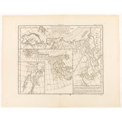
Carte des parties Nord et est de l'Asie.. (5 maps on one sheet)
Five maps on one sheet, showing California, Alaska and Syberia, Korea and Japan. South to Korea the island "Quelpaerts".The map is from Diderot's "Encyclop...
- $200 / ≈ €174
Date: Paris, 1772
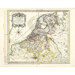
Chorographie des Pays Bas Hollandois et Autrichiens. . .
Fine detailed and uncommon map of the modern Netherlands, Belgium and Luxembourg. Prepared by Etienne André Philippe de Pretot (1708-1787) after sources according to the...
- $200 / ≈ €174
Date: Paris, 1772

(upper sheets only) Asia According to the Sieur D'Anville Divided into its Empires, Kingdoms and States Showing the European Settlements in the East Indies and all the New Discoveries . . . 1772
Highly detailed map of Russia, including Turkey, China and Korea. Based on the cartography of the famous French cartographer Jean Baptiste Bourguignon d' Anville. Only th...
Date: London, 1772
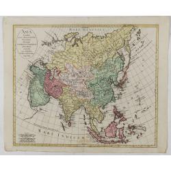
Asia secundum novas celeberrimi de l'Isle Projectiones aliorumque. . .
A pleasant map of the continent of Asia, with each country displayed in a different color. Plain oval title cartouche. A set of 5 different mileage scales lower left corn...
Date: Augsburg, 1772
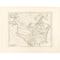
Carte des parties nord et ouest de L' Amerique. . .
An interesting map of North America, based upon an earlier map by Thomas Engel. His map of North America was issued in his 'Memoires Observations Geographique' in 1765, a...
Date: Paris, 1772
Nouvelle Representation des Cotes Nord et Est de L'Asie. . .
Three overlaid maps on one sheet. This interesting map shows northern coast of Europe and Asia, focusing on the idea of a North East Passage. Japan and Korea are shown on...
Date: Paris, 1772
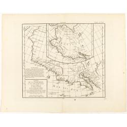
Carte de la Californie et des Pays Nord-Ouest..
From Diderot's Encyclopedia. Fascinating study of the comparative cartography of the West Coast of North America, from the Straits of Anian to Cabo San Lucas and the sout...
Date: Paris, 1772
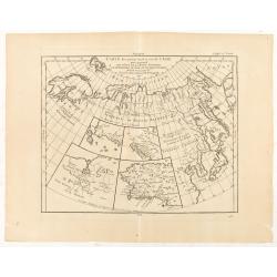
Carte des parties Nord et Est de L'Asie. . .
Five maps on one sheet, showing the Northern Russian territories in Europe and Asia, including the western coastline from Siberia, with Japan and Korea with the island of...
Date: Paris, 1772
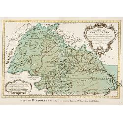
Carte de L'Indoustan. . .
Uncommon edition of this fine map of the northern part of India.From Atlas Portatif pour servir a l'intelligence de l'Histoire Philosophique et Politique des etablissemen...
- $150 / ≈ €130
Date: Amsterdam, 1773
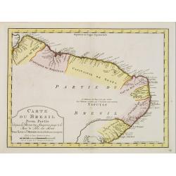
Carte du Bresil Prem.Partie...
Uncommon edition of this accurate map of the eastern part of Brazil.From Atlas Portatif pour servir a l'intelligence de l'Histoire Philosophique et Politique des etabliss...
- $100 / ≈ €87
Date: Amsterdam, 1773
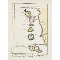
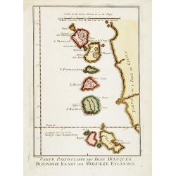
Carte Particuliere des Isles Moluques.
A very nice map centered on the island of the Moluccas.From Atlas Portatif pour servir a l'intelligence de l'Histoire Philosophique et Politique des etablissements et du ...
- $75 / ≈ €65
Date: Amsterdam, 1773
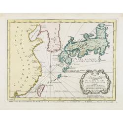
Carte des Isles du Japon.. Coree, Avec .. De la Chine..
Uncommon map of Japan, with Hokkaido, Ryukhu, Korea, Taiwan and the southeast coast of China from Peking till Macao.A mysterious "Corree" shows only a scant few...
Date: Amsterdam, 1773
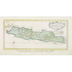
Nouvelle carte de l'Isle de Java.
A very nice map centered on the island of Java. With French text in title cartouche and an additional title in Dutch underneath the map.Read more Early maps of South East...
Date: Amsterdam, 1773
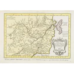
Carte de La Tartarie Orientale..
Uncommon edition of this fine map of Tartary with the Island of Sakhalin. In lower right engraved 21b.From Atlas Portatif pour servir a l'intelligence de l'Histoire Philo...
Date: Amsterdam, 1773
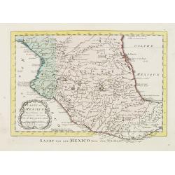
Carte du Mexique.
Uncommon edition of this fine map of Mexico. In lower right engraved 24.From Atlas Portatif pour servir a l'intelligence de l'Histoire Philosophique et Politique des etab...
- $75 / ≈ €65
Date: Amsterdam, 1773
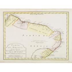
Carte du Bresil Prem. Partie..
Uncommon edition of this accurate map of eastern part of Brazil. In lower right engraved 29a.From Atlas Portatif pour servir a l''''intelligence de l''''Histoire Philosop...
Date: Amsterdam, 1773
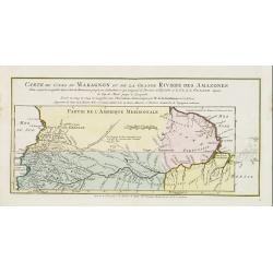
Carte du Cours du Maragnon ou .. Amazones..
Uncommon edition of this map of the river Amazon. In lower right engraved "30."From Atlas Portatif pour servir a l'intelligence de l'Histoire Philosophique et P...
Date: Amsterdam, 1773
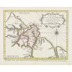
Carte de L'Isle de Caiene et de ses environs.
Uncommon edition of this accurate map of Cayenne. In lower right engraved "31."From Atlas Portatif pour servir a l'intelligence de l'Histoire Philosophique et P...
Date: Amsterdam, 1773
![Coffre Sculpté des Habitants de la nouvelle Zélande. [Tome III Pl. 13.]](/uploads/cache/26092-250x250.jpg)
Coffre Sculpté des Habitants de la nouvelle Zélande. [Tome III Pl. 13.]
A carved chest of New Zealand, as a specimen of the carving of the country. Engraving drawn after John Frederick Miller (1759-1796). John Frederick Miller was an English ...
Date: Paris, 1773
![Vue de la Rivière d'Endeavour sur la Côte de la Nouvelle Hollande ou le Vaisseau fut mis à la bande. [Tome IV Pl. 1ère.]](/uploads/cache/26093-250x250.jpg)
Vue de la Rivière d'Endeavour sur la Côte de la Nouvelle Hollande ou le Vaisseau fut mis à la bande. [Tome IV Pl. 1ère.]
The first known landscape drawing of the east coast of Australia. A View of the Endeavour River, on the coast of New Holland, where the ship was laid on shore, in order t...
Date: Paris, 1773
![Hausse-col militaire des insulaires de la Mer du Sud. [Tome II Pl. 12.]](/uploads/cache/26095-250x250.jpg)
Hausse-col militaire des insulaires de la Mer du Sud. [Tome II Pl. 12.]
Maori warrior rise-collar. From the French edition of James Cook's first voyage entitled Relation des voyages entrepris par ordre de sa Majesté Britannique actuellement ...
Date: Paris, 1773
![Instruments des insulaires de la Mer du Sud. [Tome II Pl. 15.]](/uploads/cache/26097-250x250.jpg)
Instruments des insulaires de la Mer du Sud. [Tome II Pl. 15.]
Divers tools. From the French edition of James Cook's first voyage entitled Relation des voyages entrepris par ordre de sa Majesté Britannique actuellement régnante pou...
Date: Paris, 1773
![Emouchoir des Otahitiens avec ses manches. [Tome II Pl. 13.]](/uploads/cache/26098-250x250.jpg)
Emouchoir des Otahitiens avec ses manches. [Tome II Pl. 13.]
The print depicts three ceremonial fly-whisks from Tahiti. Each object features ornate carved handles with anthropomorphic figures and long flowing fibers, accompanied by...
Date: Paris, 1773
![Le Capitaine Wallis est attaqué dans le Dauphin par les Otahitiens. [Tome II Pl. 1ère.]](/uploads/cache/26099-250x250.jpg)
Le Capitaine Wallis est attaqué dans le Dauphin par les Otahitiens. [Tome II Pl. 1ère.]
Scene of an attack by local Tahitians on Captain Wallis' Dolphin ship off Tahiti's shore. Samuel Wallis (1728-95), a Royal Navy Captain and a skilled navigator was given ...
- $150 / ≈ €130
Date: Paris, 1773
![Vue de l'Isle d'Otahiti et de plusieurs Pirogues. [Tome II Pl. 11.]](/uploads/cache/26102-250x250.jpg)
Vue de l'Isle d'Otahiti et de plusieurs Pirogues. [Tome II Pl. 11.]
View of the Island of Tahiti and dugouts. From the French edition of James Cook's first voyage entitled Relation des voyages entrepris par ordre de sa Majesté Britanniqu...
Date: Paris, 1773
![Vue de l'Isle d'Ulietéa avec une double Pirogue et un hangar où les Insulaires retirent leurs bâtiments de mer. [Tome III Pl. 5.]](/uploads/cache/26106-250x250.jpg)
Vue de l'Isle d'Ulietéa avec une double Pirogue et un hangar où les Insulaires retirent leurs bâtiments de mer. [Tome III Pl. 5.]
A view on the Island of Ulietea, French Polynesia, of a dugout boat house and a beautifully engraved pirogue at sea. From the French edition of James Cook's first voyage ...
Date: Paris, 1773
![Vue de l'Isle d'Huaheine avec La Maison de Dieu, et un petit Autel couvert d'offrandes. [Tome III Pl. 4.]](/uploads/cache/26108-250x250.jpg)
Vue de l'Isle d'Huaheine avec La Maison de Dieu, et un petit Autel couvert d'offrandes. [Tome III Pl. 4.]
A view of the Island of Huaheine, Tahiti, a beautiful tropical Owharra tree in the foreground and a depiction of the House of God with its offertory. From the French edit...
Date: Paris, 1773
![Vue d'un Rocher troué de la Nouvelle Zélande. [Tome III Pl. 8.]](/uploads/cache/26112-250x250.jpg)
Vue d'un Rocher troué de la Nouvelle Zélande. [Tome III Pl. 8.]
A view of a New Zealand landscape and seascape through a hollow rock. Engraved by Demouchy. From the French edition of James Cook's first voyage entitled Relation des voy...
Date: Paris, 1773
![Manière dont on expose les morts à Otahiti. [Tome II Pl. 16.]](/uploads/cache/26113-250x250.jpg)
Manière dont on expose les morts à Otahiti. [Tome II Pl. 16.]
A view of a Tahitian funeral home in a beautiful landscape. Engraved by Demouchy. From the French edition of James Cook's first voyage entitled Relation des voyages entre...
Date: Paris, 1773

Carte de la Coste d'Arabie.
Uncommon issue of this very nice map of the Arabian peninsula. Depicted is Saudi Arabia, Red Sea and the Persian Gulf.With French text in title cartouche and an additiona...
Date: Amsterdam, 1773
![Vue d'un Rocher troué de la Nouvelle Zélande. [Tome III Pl. 8.]](/uploads/cache/29073-250x250.jpg)
Vue d'un Rocher troué de la Nouvelle Zélande. [Tome III Pl. 8.]
A view of a New Zealand landscape and seascape through a hollow rock. Engraved by Demouchy. From the French edition of James Cook's first voyage entitled Relation des voy...
- $75 / ≈ €65
Date: Paris, 1773
Carte Particuliere des Isles Moluques. . .
A very nice map centered on the island of the Moluccas.Title in French and in Dutch underneath the map.
Date: Amsterdam, 1773
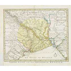
Nouvelle carte du Royaume de Bengale.
Uncommon issue of this detailed map of Bangladesh with the Ganges delta, including Calcutta. Giving great detail with trade routes, European trade settlements, etc. Prepa...
- $380 / ≈ €330
Date: Amsterdam, 1773
Mappa Geographica Regni Poloniae ex novissimis quotquot sunt mappis specialibus composita et al L.L. Stereographicae projectionis revocata a Tob. Mayero. . . .
Late Tobias Mayer detailed map Polish edition, updated in order to show the borders of the kingdom of year 1772 after the division of the territory.Mayer's map extends fr...
- $750 / ≈ €651
Date: Nuremberg, 1773
The Russian Empire, from the Best Authorities, by Thos. Kitchin, Geographer.
Showing the Asian part of Russia, with interesting note to a coast line north of Siberia "Land seen in 1723", likely referring to Vitus Bering (1681–1741), wh...
- $150 / ≈ €130
Date: London, c. 1773
Carte de la Nouvelle Angleterre, Nouvelle York et Pensilvanie / Pour servir à l'Histoire Générale des Voyages.
Uncommon edition of this accurate map the east coast from Delaware River till Main.Left hand corner Lake Ontario. In lower right engraved "38."From Atlas Portat...
- $275 / ≈ €239
Date: Amsterdam, 1773
Carte de la province de Quan-tong, ou Lyau-tong et du Royaume de Kau-li ou Corée. . . / Kaart van t' Landschap Quan-Tong . . .
Uncommon issue of this fine map of Korea. The map is of interest for the use of East Sea, the sea between Korea and Japan, here called "Mer de Corée.Decorative titl...
Date: Paris, 1749-1773
Neue und vollständige Topographie der Eidgnossschaft, in welcher die in den dreyzehen und zugewandten auch verbündeten Orten und Landen dermal befindliche Städte, Bischthümer, Stifte, Klöster, Schlösser, Amts-Häuser, Edelsitze und Burgställe...
The first edition of Herrliberger's work on the topography of Switzerland. - The rarest book on Switzerland rarely found complete.Illustrated with an engraved allegorical...
- $5500 / ≈ €4773
Date: Zurich, Johann Kaspar Ziegler, 1754-1773
Mappa Geographica Regni Poloniae ex novissimis quot quot sunt mappis. . .
A map of Poland, Lithuania and Belarus, first published in 1750 by Homann Heirs, and now re-issued in 1773. Coastline includes all between Riga and Gdansk. Map is based o...
Date: Nuremberg, 1773
![[Set of a title and frontispiece from Hydographie Françoise. . . Vol 1 ]and 2]](/uploads/cache/47733-250x250.jpg)
[Set of a title and frontispiece from Hydographie Françoise. . . Vol 1 ]and 2]
Very decorative title page and frontispiece of Hydographie Françoise, published by Jacques-Nicolas Bellin in 1772 and 1773. The title page was engraved in 1765 and is da...
- $750 / ≈ €651
Date: Paris, 1773
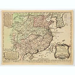
L'Empire de La Chine../ 't Keizerryk van China..
An attractive map of China with Korea and Taiwan (I.Tay-wan, ou Formosa) and "Mer de Coree'. There are decorative title cartouches in three corners of the map. The u...
- $200 / ≈ €174
Date: The Hague, 1773

Kerk te Asten in Peelland.
"Etching of the church of Asten, from ""Het Verheerlijkt Nederland of Kabinet van hedendaagsche gezichten.."" published by Isaac Tirion in Amster...
Date: Amsterdam 1745-1774

Kapel van Vlierden.
Etching of the old chapel of Vlierden (near Deurne), from Het Verheerlijkt Nederland of Kabinet van hedendaagsche gezichten.. published by Isaac Tirion in Amsterdam. Etch...
Date: Amsterdam 1745-1774
![[Insects]](/uploads/cache/09188-250x250.jpg)
[Insects]
Decorative plate from Naauwkeurige waarneemingen omtrent de veranderingen van veele insekten of gekorvene diertjes. Engraved by Ludwig Schmidt after Jablonsky. Printed by...
- $40 / ≈ €35
Date: Amsterdam, 1774

Terrae Yemen Maxima Pars, seu Imperii Imami, Principatus Kaukeban nec non ditionum Haschid u Bekil, Nehhm, Chaulan, Abu Arisch et Aden Tabula ...
South-west Arabia, with the Saudi Arabian city of Jizan south to Aden. With a fine title, cartouche. Based on a map by Carsten Niebuhr. With the name Sinus Arabicus Mare ...
Date: Augsbourg, 1774
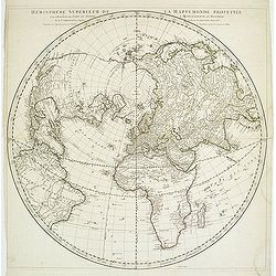
Hémisphère Supérieur de la Mappemonde projetée sur l'Horizon. . .
Hemisphere on a partial polar projection. The Northern Hemisphere (of 2) is centered on Paris emphasizing the continents. Hemisphere measures 24.5. Alaska is shown as an ...
Date: Paris, 1774