Browse Listings
![[Title page] Cartes de geographie les plus nouvelles et les plus fideles, Avecque leurs divisions regulieres, par P. Du Val Géographe Ordinaire du Roy.](/uploads/cache/48000-250x250.jpg)
[Title page] Cartes de geographie les plus nouvelles et les plus fideles, Avecque leurs divisions regulieres, par P. Du Val Géographe Ordinaire du Roy.
Title page from the atlas "Cartes de geographie les plus nouvelles et les plus fideles, Avecque leurs divisions regulieres" of Duval.In the top a crowned globe ...
- $400 / ≈ €347
Date: Paris, after 1656
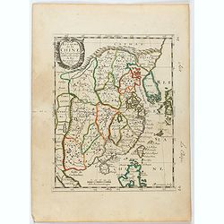
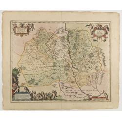
Royaume de la Chine. . .
Detailed map of China. Engraved by A.Winter. Attractive miniature map, depicting Korea as an island and parts of Japan, i.e. western part of Honshu and Kyushu.
Date: Paris, 1656
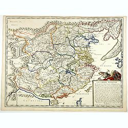
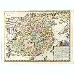
La Chine Royaume. . .
An important and attractive French map of the whole of China, the northern tip of the Philippines, with a strangely curved Korea and an under-sized Taiwan here called &qu...
- $2600 / ≈ €2256
Date: Paris, 1656
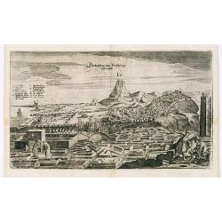
View of Derbendt an der Persischen Grentze.
An early view of Derbent, in the Republic of Dagestan. From "Voyages en Moscovie, Tartarie et Perse, par Adam Olearius".Adam Olearius was a seventeenth-century ...
Date: Paris, Abraham de Wicquefort , 1656
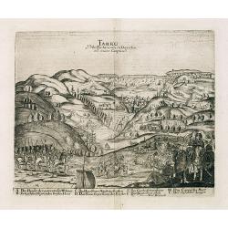
Tarku Urbs Tartaroum in Dagestan ad mare Caspium.
An early view of Tarku, in the Republic of Dagestan. From "Voyages en Moscovie, Tartarie et Perse, par Adam Olearius".Adam Olearius was a seventeenth-century G...
Date: Paris, Abraham de Wicquefort , 1656
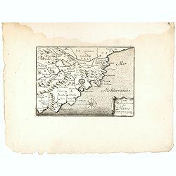
L'evesché d'Aire. . .
In center Adour (river), Aire-sur-l'Adour, with Aire and Dax in lower right corner. Janssonius does give credit to Pierre du Val. In lower left corner putti with grapes.D...
- $300 / ≈ €260
Date: Amsterdam, 1656
La Chine Royaume. . .
An important and attractive French map of the whole of China, northern tip of the Philippines, with a strangely curved Korea and an under-sized Taiwan here called "Y...
Date: Paris, 1656
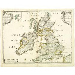
Carte Generale des Royaume d'Angleterre Escosse et Irlande Avecq les Isles circonvoisines Conues toutes soubs le nom de Britanniques / Nouvellement dressee et tiree de Cambdene Spede & autres Par N. Sanson geogr.e Ord.re du Roy
Fine map of the British Isles. The map was first published by Tavernier and later by Mariette. This edition carries the date 1640 and the address of Pierre Mariette: rue ...
- $350 / ≈ €304
Date: Paris, 1640-1657
![Mexico, Regia et Celebris Hispaniae Novae Civitas ... [on sheet with] Cusco, Regni Peru in Novo Orbe Caput.](/uploads/cache/29013-250x250.jpg)
Mexico, Regia et Celebris Hispaniae Novae Civitas ... [on sheet with] Cusco, Regni Peru in Novo Orbe Caput.
Two bird's-eye views on one sheet: Mexico and Cusco.Showing Mexico City and Cusco, the capital cities of the Aztecs and Incas, with the major buildings shown in profile w...
Date: Amsterdam, 1657
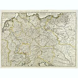
Carte generale de L'Empire d'Allemagne et pays circonvoisins. . .
Fine map of Germany, Low countries, Switzerland, Austria and Poland. The map was first published by Tavernier and later by Mariette. This edition carries the date 1642 an...
- $200 / ≈ €174
Date: Paris, 1642/45-1657

Moscovia urbs Metropolis totius Russiae Albae.
Detailed bird's-eye town-plan of Moscow from Janssonius' rare townbook. With a key (1-20) to important spots in town. The verso has French text and originates from Jansso...
Date: Amsterdam, 1657
![[Title page] De insectis libri III, de serpentibus et draconibus libr II.](/uploads/cache/22364-250x250.jpg)
[Title page] De insectis libri III, de serpentibus et draconibus libr II.
Title page from : Historiae Naturalis de Quadrupedibus libri.The re-edition of the edition of Frankfurt of 1650-53 illustrated with mirror imaged copper engravings after ...
Date: Amsterdam, 1657
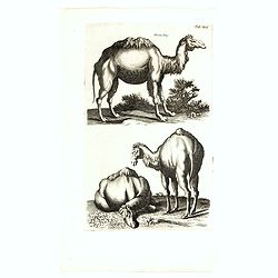
Dromedary.
Decorative and early copper engraving showing three dromedaries : Historiae Naturalis de Quadrupedibus libri.The re-edition of the edition of Frankfurt of 1650-53 illustr...
Date: Amsterdam, 1657
Dicecese de Rheims, et le païs de Rethel. . .
Centered on Rheims. A very decorative map with beautiful cartouches of a province of France by one of the most famous map publishers.
- $300 / ≈ €260
Date: Amsterdam, 1658
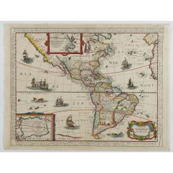
Carte de L'AMERIQUE Corrigeé et argumenteé….
Separately published map published in 1658 but based on Petrus Bertius map of 1624., this on its turn taken from Jodocus Hondius map of 1618. On the sides he lists the pr...
Date: Paris, 1658
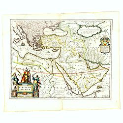
Turcicum Imperium.
A very handsome map with a particularly fine cartouche showing the Turkish Sultan on his throne and allegorical figures at either side brandishing weapons. At right is a ...
- $1500 / ≈ €1302
Date: Amsterdam, 1658

De Zype. / Purmer / Wormer/ Beemster / Waterland.
Five maps on one sheet. Showing the polders of De Zype, De Purmer, De Wormer, De Beemster and a map of Waterland, including de Bylmermeer and Monnekedam. Showing the Noor...
Date: Amsterdam, 1652-1658

Pascaerte van Brazil en Nieu Nederlandt van Cuorvo en Flores.
A rare chart of the Atlantic Ocean from the first edition of Hendrick Doncker's Zee-Atlas, of which no surviving example is known.Although the idea of its unusual coverag...
Date: Amsterdam, 1658
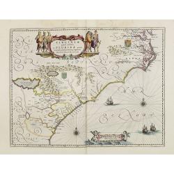
Virginiae Partis Australis, et Floridae Partis Orientalis.
Blaeu based this map on the Mercator-Hondius of 1606. A number of geographical improvements, however were incorporated, although two large fictions lakes accompanied by e...
Date: Amsterdam, 1658
(Title page ) Topographia Galliae. . .
Title page from Casper Merian's Topographia Galliae...See other Title Pages [+]
- $30 / ≈ €26
Date: Frankfurt, 1658
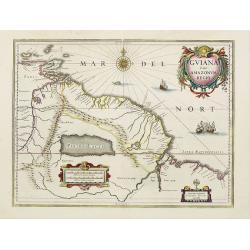
Guiana sive Amazonum Regio.
A very decorative map of Suriname which extends from the Isla Margarita in the northwest to the coast of northern Brazil near Sao Luis east of the Amazon delta. The map l...
- $450 / ≈ €390
Date: Amsterdam, 1658
(Title page) Topographia Galliae. . .
Title page from Casper Merian's Topographia Galliae... Read more about title pages [+]
- $35 / ≈ €30
Date: Frankfurt, 1658
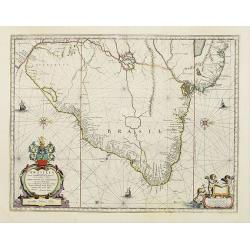
Brasilia.
A mint example of this map is by Krystof Arciszewski, a Polish general who worked for the Dutch West Indian Company. The map perpetuates various myths including the Parim...
- $1250 / ≈ €1085
Date: Amsterdam, 1658
Dioecesis Sarlatensis, Vernacule.. Sarlat.
Detailed map of the region south of the Dordogne River, depicting Bergerac, Saint Cyprien, Montignac, Sarlat, Villefranche, etc.Embellished with an impressive title carto...
- $200 / ≈ €174
Date: Amsterdam, 1658

Tabula Magellanica.
A map with Willem Blaeu's signature, but published by his son Joan, of South America's extremity with the Strait of Magellan and Le Maire Strait.The coastlines are depict...
Date: Amsterdam, 1658
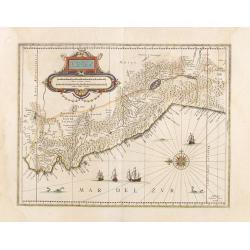
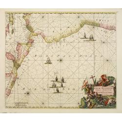
Peru.
Decorated with ships and monsters on the sea. Orientated with east at the top. Shows the Pacific coast of South America from Ecuador (at the left-hand side) as far south ...
- $400 / ≈ €347
Date: Amsterdam, 1658
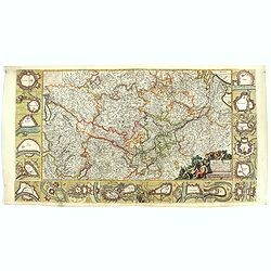
![Magni Ducatus Lithuaniae. . . (together with] Campus Inter Bohum et Borystenem. . .](/uploads/cache/49232-250x250.jpg)
Magni Ducatus Lithuaniae. . . (together with] Campus Inter Bohum et Borystenem. . .
Six sheet wall map of Lithuania and parts of Poland, Russia, Ukraine, Latvia, etc., extending to Cracow, Kyiv, Warsaw, Riga, Konigsberg, Danzig, Leopolis, etc.This is the...
Date: Amsterdam, 1658

Wassende graade paskaart vertonende alle de Zeekusten van Europa, de geheele middelandsche Zee…
Wassende graade paskaart vertonende alle de Zeekusten van Europa, de geheele middelandsche Zee, als cock ten Noordwesten, en Noordoosten soo veer als ons tot noch toe bek...
Date: Amsterdam, 1658
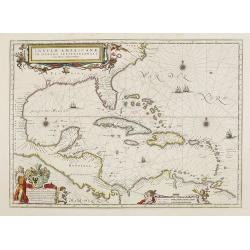
Insulae Americanae in Oceano Septentrionali cum Terris adiacentibus.
General map of the West Indies extending from Virginia to the mouth of the Orinoco, and destined to be copied in various shapes by many other publishers. Title cartouche ...
- $1500 / ≈ €1302
Date: Amsterdam, 1658
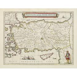
Natolia, quae olim Asia minor.
A finely designed map of Turkey and Cyprus from the great Blaeu family of Amsterdam. The decoration consist of a colored title cartouche, sea monsters, a naval engagement...
- $450 / ≈ €390
Date: Amsterdam, 1658
Tartaria sive Magni Chami imperium.
This is a detailed and decorative map of the Tartary and northern part of China, including the Chinese Great Wall, the Caspian Sea, and the Volga River east as far as the...
- $700 / ≈ €607
Date: Amsterdam, 1658
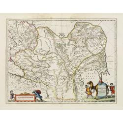
Magni Mogolis Imperium.
An attractive map of the northern part of India, Tibet, Iran to Burma. The travel route from Kabul to Surat is the most prominent feature of the map. Richly decorated wit...
- $650 / ≈ €564
Date: Amsterdam, 1658

Pascaerte vande Caribische Eylanden, vande Barbados tot aende Bocht van Mexico ‘t Amsterdam By Hendrick Doncker. . .
First state. Rare. “This chart appeared in the first edition of Hendrick Doncker’s Zee-Atlas, of which no surviving example is known” -- Burden. This is an example ...
Date: Amsterdam, 1659
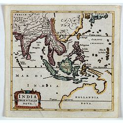
India Orientalis Nova.
Charming uncommon miniature map showing the northern two-thirds of Australia pre-discoveries by Captain Cook, but showing discoveries by Abel Tasman in 1642. The map show...
- $750 / ≈ €651
Date: Amsterdam, 1659

Insula Huaena sive Venusia a Guiljelmo Blaeu cum sub Tychone Astronomiae operam ...
Decorative map of the island Hvan in the Danish Sound. In the center Tycho Brahe's famous observatory Uraniborg established in 1576, under the patronage of Frederick II, ...
Date: Amsterdam, 1659
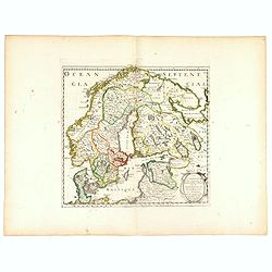
La Scandinavie et les environs ou sont les royaumes de Suede, de Danemarck et de Norwege. . .
The standard map of Scandinavia in 17th century France. Engraved by A.Peyrouin.Nicolas Sanson was to bring about the rise of French cartography, although the fierce compe...
Date: Paris, 1647-1659
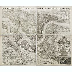
Description au naturel de la ville de Lyon et païsages alentour d'icelle.
PREMIERE EDITION. Plan de Lyon à « vol d’oiseau » commandé par le consulat, destiné à la diffusion et à la notoriété de la cité, mariant ainsi image de la vil...
Date: Lyon, 1659
Vera Delineatio Provinciae Fertilissimae Kilan olim Hyrcaniae ad Mare Caspium Sitae.
Uncommon map prepared by Adam Olearius showing the region of Azerbaijan and Iran. The map is oriented with north to the upper left corner and adorned with an attractive t...
- $400 / ≈ €347
Date: Jean Dupuis in Paris, 1659
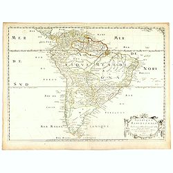
Amerique Meridionale. . . 1650.
First edition. A fine large map of South America, engraved by A.Peyrounin. The relatively unknown Amazon region is left without speculation. However, Sanson includes the ...
- $450 / ≈ €390
Date: Paris, 1650-1659

(China Atlas) Atlas Nuevo de la Extrema Asia o descripcion geographica del Imperio de los Chinas. Por el R.P. MARTINO MARTIONIO de la Compania de Iesu.
RARE SPANISH text edition of the First European Atlas of China. 15 of 17 engraved maps in original hand-color, and engraved title pages in original hand-color, heightened...
Date: Amsterdam, 1658-1659

Neapolis.
A rare panoramic of Naples with over the whole length of the lower part 3 columns of poems in Latin, Dutch and French.Published by Dancker Danckerts (1634-1666).
Date: Amsterdam, 1660
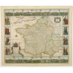
Nova Haec tabula Galliae. . .
Dated 1660. This handsome map of France is dedicated to Louis XIV, interesting in light of the nearly constant warfare between Louis and the Netherlands in the ensuing ye...
Date: Amsterdam, 1660
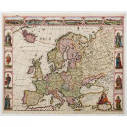
Nova Europae descriptio.
Four panels in columns on each side show portraits of Kings and Queens of European countries. The top border contains panoramas of Rome, Amsterdam, Paris, London, Seville...
Date: Amsterdam, c. 1660
Russie blanche ou Moscovie.
Map of the European part of Russia centered on Moscow and prepared by N.Sanson. Published in an early edition of the small Sanson atlas L'Europe Dediée a Monseigneur . ....
- $100 / ≈ €87
Date: Amsterdam, ca. 1660
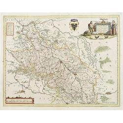
Champaigne et Brie etc.
A good engraved map of Champagne-Ardenne area, embellished with decorative title cartouche and scale cartouche with putti and surveying instruments. Paris, Metz, Reims, a...
- $150 / ≈ €130
Date: Paris, ca. 1660
Nova Hispaniae, Chili, Peruviae, et Guatimalae Littorae..
A superbly decorative chart, oriented with north to the left of the sheet, covering the coasts of Central America, Peru, Chile, Jamaica and part of Cuba and Porto Rico. S...
- $1000 / ≈ €868
Date: Amsterdam, 1660
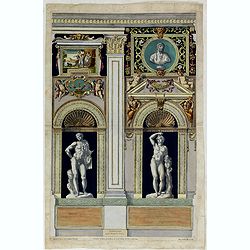
Tabula IV sequitur Farnesiana Posticus.
Ornamental representation of Temple St. Mariae in Rome by Petrus Aquila (1650-1692), after Annibale Carracci. Inscribed in the plate. "Petrus Aquila delin at sculp. ...
Date: Rome, 1660
Insulae Iavae Cum parte Insularum Borneo Sumatrae, et Circumjacentium Insularum Novissima Delineatio.
This elegant chart focuses on the island of Java with parts of Sumatra, Borneo and Bali. The lack of interior detail correctly reflects the state of knowledge of the peri...
Date: Amsterdam, 1660
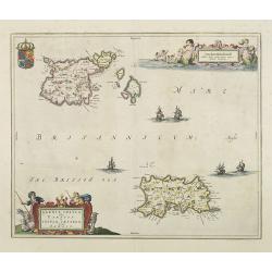
Sarnia Insula vulgo Garnsey et Insula Caesarea venacule Jarsey
Fine map depicting the English islands of Jersey and Guernsey is entitled : "Sarnica Insulavulgo Garnsey et Insula Caesarea vernacule Jarsey". In the cartouche...
- $475 / ≈ €412
Date: Amsterdam, 1660
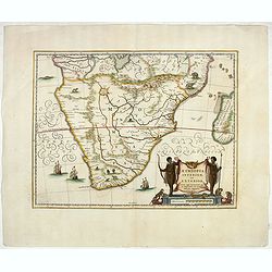
Aethiopia inferior, vel exterior.
The standard map of South Africa throughout the 17th century. The lake out of which the 'Zambere' -the Zambesi- flows is probably based on reports of Lake Ngami, undiscov...
- $800 / ≈ €694
Date: Amsterdam, ca. 1660
Silesiae Ducatus..
Centered on Breslaw. Including the towns of Dresden, Crakaw, Pragu, Olmitz, etc.Decorative map prepared by Jonas Scultetus, a Silesian cartographer (1603-1664).
- $600 / ≈ €521
Date: Amsterdam 1660
Geographische Beschryvinghe van de wandeling der apostelen ende De Reysen Pauli. . .
In upper and lower part 9 vignettes showing scenes from Paul's wanderings.
- $500 / ≈ €434
Date: Amsterdam, 1660
![[Map of river Rhine.]](/uploads/cache/47453-250x250.jpg)
[Map of river Rhine.]
Map of the River Rhine from Boden See until Wesel. Left hand part of a 2-sheet map.
Date: Amsterdam, 1660
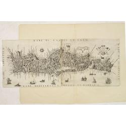
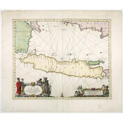
Il Regno Di Candia.
This rare map is based on the important map of Crete by Basilicata. The maps by Marco Boschini reached a wider audience than the few individuals for whom the Basilicata m...
Date: Venice, 1660
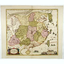
Imperii Sinarum nova descriptio.
Schenk and Valk's rare early 18th century issue of Janssonius milestone map of China, Korea and Japan after Martino Martini. Engraved by Johannes van Loon. The overall ba...
- $1600 / ≈ €1388
Date: Amsterdam, ca. 1660

Pascaarte, van de Zuijderzee, Vliestroom, Vlie, en Amelandergat…
Very rare chart of the Dutch Zuiderzee, here in its rare 5th state (o f6). Showing the coastlines along the Dutch inner sea. Two compass roses indicate north to the left ...
Date: Amsterdam, c. 1660
Fluviorum Rheni Mosae Mosellae Moeni Neccaris aliorumque minorum in eosdem se exonerantium et regionum circumjacentium descriptio
Fluviorum Rheni Mosae Mosellae Moeni Neccaris aliorumque minorum in eosdem se exonerantium et regionum circumjacentium descriptio Decorative map with 18 vignettes on thr...
- $750 / ≈ €651
Date: Amsterdam, ca. 1660

Nova Africa descriptio.
A beautifully engraved and most attractive "carte à figures"- map of the African continent. Bordered, above, by panels showing panorama's of Cairo, Alexandria,...
Date: Amsterdam, after 1660
![De Texel Stroom met de gaten vant Marsdiep. [with] Caarte van De Mase ende het Goereesche Gat.](/uploads/cache/12097-250x250.jpg)
De Texel Stroom met de gaten vant Marsdiep. [with] Caarte van De Mase ende het Goereesche Gat.
Two decorative charts on one sheet, one depicting Texel and the entrance of the Zuider Zee with an inset showing the north coast of West-Friesland, the other depicting th...
Date: Amsterdam, 1660
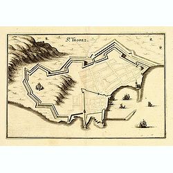
St Tropez.
Plan of St Tropez by M.Merian. Depicts a street layout and ships in harbour etc.
- $130 / ≈ €113
Date: Frakfurt, 1660
Carte generalle d'allemaigne nouvellement misse en françois et Ampliffiée de tous les Royaumes. . .
Attractive and rare map of Germany, the Low Countries, Austria, Moravia, Switzerland and part of Poland.
Date: Paris, 1632-1660

Magnus Ducatus Finlandiae Auct. Andrea Bureo Succo.
The first printed survey map of Finland, composed by the Swedish cartographer Anders Bureus (1571-1661). The map was published in 1662 in the second volume of Joan Blaeu'...
Date: Amsterdam, 1660

Poli Arctici, et circumiacentium terrarum descriptio novissima. . .
A re-issue of the Hondius' plate. A particularly decorative map of the North Pole with Iceland. Several Dutch names in Labrador. The toponymy in Canada reflects the conti...
Date: Amsterdam, 1660

De Texel Stroom .. vant Marsdiep./ Caarte van De Mase...
Two decorative charts on one sheet, one depicting Texel and the entrance of the Zuider Zee with an inset showing the north coast of West-Friesland, the other depicting th...
Date: Amsterdam, 1660
Carte du Gouvernement de Blanes.
Decorative print of the area around Blanes, in Catalonia. Engraved by Pérelle. Embellished with a compass rose.
- $80 / ≈ €69
Date: Paris ca. 1660
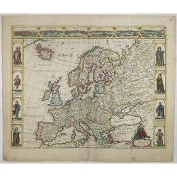
Nova Europae descriptio.
A fine "carte à figures"- map with four panels in columns on each side show portraits of Kings and Queens of European countries. The top border contains panora...
Date: Amsterdam, 1660

Sumatrae et insularum Locorumque nonnullorum circumiacentium. . .
Fine depicting the Island of Sumatra and the southern coasts of Malaysia from Quedo to Johore.North is orientated to the left of the page.Singapore is probably identifie...
Date: Amsterdam, 1660
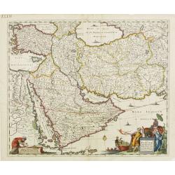
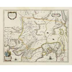
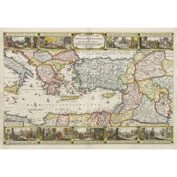
Nova Persiae, Armeniae, Natoliae et Arabiae.
East from Cyprus to Iran with numerous place names and ornamental cartouches below. There are vignettes of sailing ships in sea areas and the land divisions of the time a...
- $850 / ≈ €738
Date: Amsterdam, 1660
Flandria Gallica Continens Castellanias Insulense . . .
No text on verso. Map of northern part of France, centered on Lille and part of Belgium.
Date: Amsterdam, c. 1660
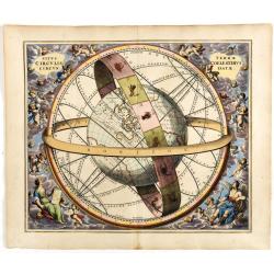
Situs Terrae Circulis Coelestibus circundatae..
A celestial chart depicting a large globe centered on Australia and the Pacific, with California depicted as an island, and South East Asia encircled by the zodiacal band...
Date: Amsterdam, Janssonius, 1660
Quantung Imperii Sinarum Provincia duodecima.
A beautifully engraved map of Southern China covers Hainan, the Pearl River Delta, and Greater Hong Kong.A legend at left identifies cities and towns of various sizes, fo...
Date: Amsterdam, 1660

Paraquaria vulgo Paraguay cum adjacentibus.
Rare map only included in Joan Blaeu's Atlas major. Detailed map of Uruguay, Paraguay, Northern part of Argentina and northern part of Chili. Engraved by Gerard Coeck. Tw...
- $800 / ≈ €694
Date: Amsterdam, 1660
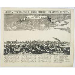
Constantinopolitanae urbis effigies ad vivum expressa.
A rare panoramic town-view of Istanbul with over the whole length of the lower part 3 columns of poems in Latin, Dutch and French and a numbered key 1-29 to the principal...
Date: Amsterdam, 1660
Russiae, vulgo moscoviae dictae, partes septentrionalis et orientalis.
A finely engraved depiction of the area from Estonia to Moscow. The map is based on the travels of Isaac Massa, who visited Moscow in the early 1600s and thus was in the ...
- $550 / ≈ €477
Date: Amsterdam, 1660
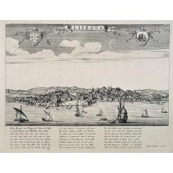
Lisbona.
A rare panoramic view of Lisbon with over the whole length of the lower part 3 columns of poems in Latin, Dutch and French.Published by Dancker Danckerts (1634-1666)Colle...
Date: Amsterdam, 1660
![Praga. [Prague]](/uploads/cache/28442-250x250.jpg)
Praga. [Prague]
A rare panoramic of Prague with over the whole length of the lower part 3 columns of poems in Latin, Dutch and French and a numbered key 1-34 to the principal buildings ...
Date: Amsterdam, 1660

Xantung, sinarum imperii provincia quatra.
A map of the northern province ‘Xantung’ of China after the Jesuit Martino Martini.Shows the Great Wall and is centered on the Bohai Sea, and the Shandong and Liaonin...
Date: Amsterdam, ca 1660
Prussia accurate descriptia a Gasparo Henneberg Erlichensi.
Prussia and the Baltic Region, with two large decorative cartouches, coat of arms and three sailing ships. As indicated in the title cartouche, the map was prepared by th...
- $900 / ≈ €781
Date: Amsterdam, 1660
![[Title page] L'Europe . . .](/uploads/cache/27759-250x250.jpg)
[Title page] L'Europe . . .
Title page from N. Sanson atlas, with a dedication to François Michel Le Tellier, (18 janvier 1641, Paris - 16 juillet 1691, Versailles).His atlas was called "L'Eur...
- $90 / ≈ €78
Date: Amsterdam, 1660

Pecheli, Xansi, Xantung, Honan, Nanking, In plaga Regni Sinensis. . .
A map of the northern provinces of China after the Jesuit Martino Martini, depicting of Hebei (Pecheli), Shanxi (Xansi), Shandong (Xantung), Henan (Honan), and Jangsu (Na...
Date: Amsterdam, ca 1660