Subscribe to be notified if similar examples become available.
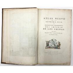

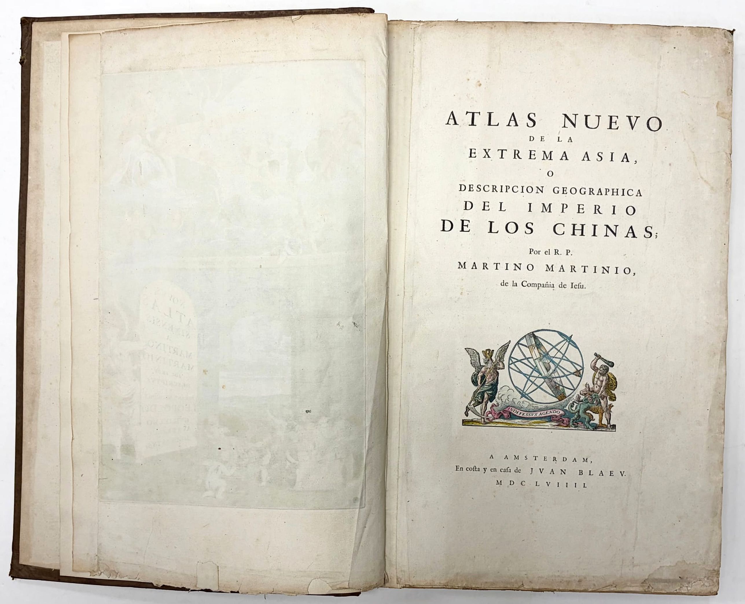
(China Atlas) Atlas Nuevo de la Extrema Asia o descripcion geographica del Imperio de los Chinas. Por el R.P. MARTINO MARTIONIO de la Compania de Iesu. |
||||||||||||||||||||
|
||||||||||||||||||||
|
|
||||||||||||||||||||
|
|
Virtual Collection - Save and collect this or any of your favorite items in one place.
If you want to save the items permanently, please sign in or create account first. |
|||||||||||||||||||
Description
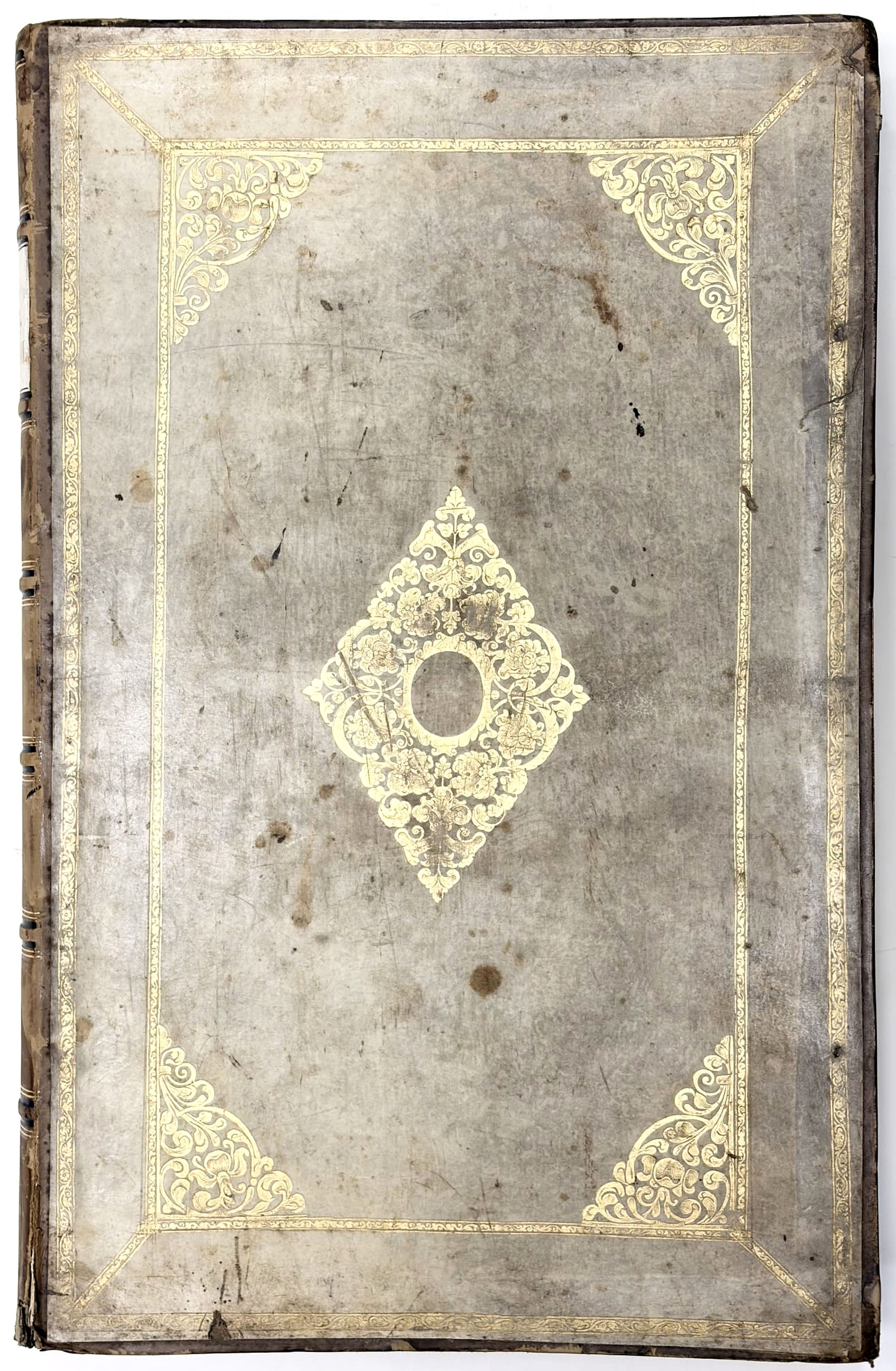
RARE SPANISH text edition of the First European Atlas of China. 15 of 17 engraved maps in original hand-color, and engraved title pages in original hand-color, heightened in gold. Original gilted velum covers pasted on19th century calf boards, with monogram.
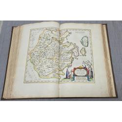
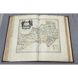
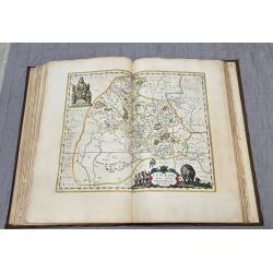
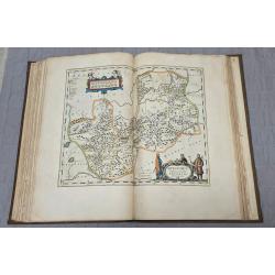
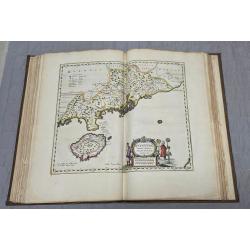
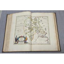
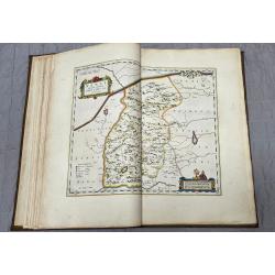
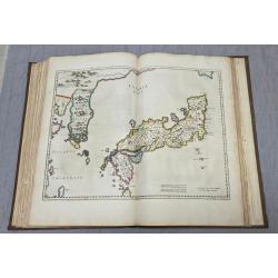
There is only one edition of the Spanish text edition of China. This is the first western atlas of China, including sixteen engraved maps of Chinese subjects, and one general map of Japan, all in beautiful original outline hand-color.
The present work is based on the surveying and compiling work of Father Martinus Martini, the Jesuit Superior of Hangzhou.
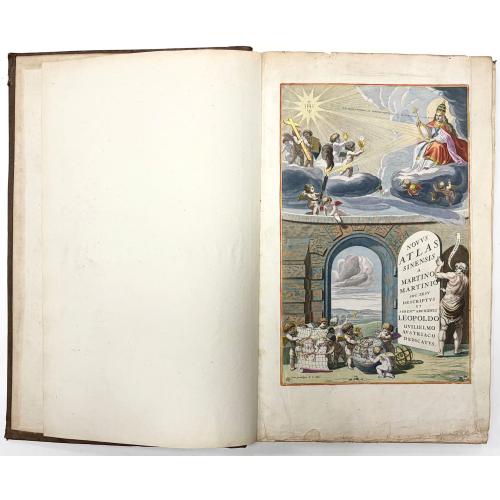
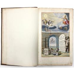
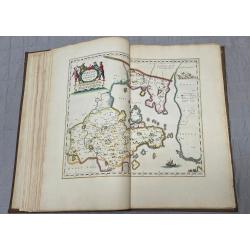
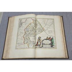
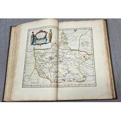
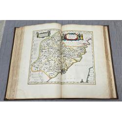
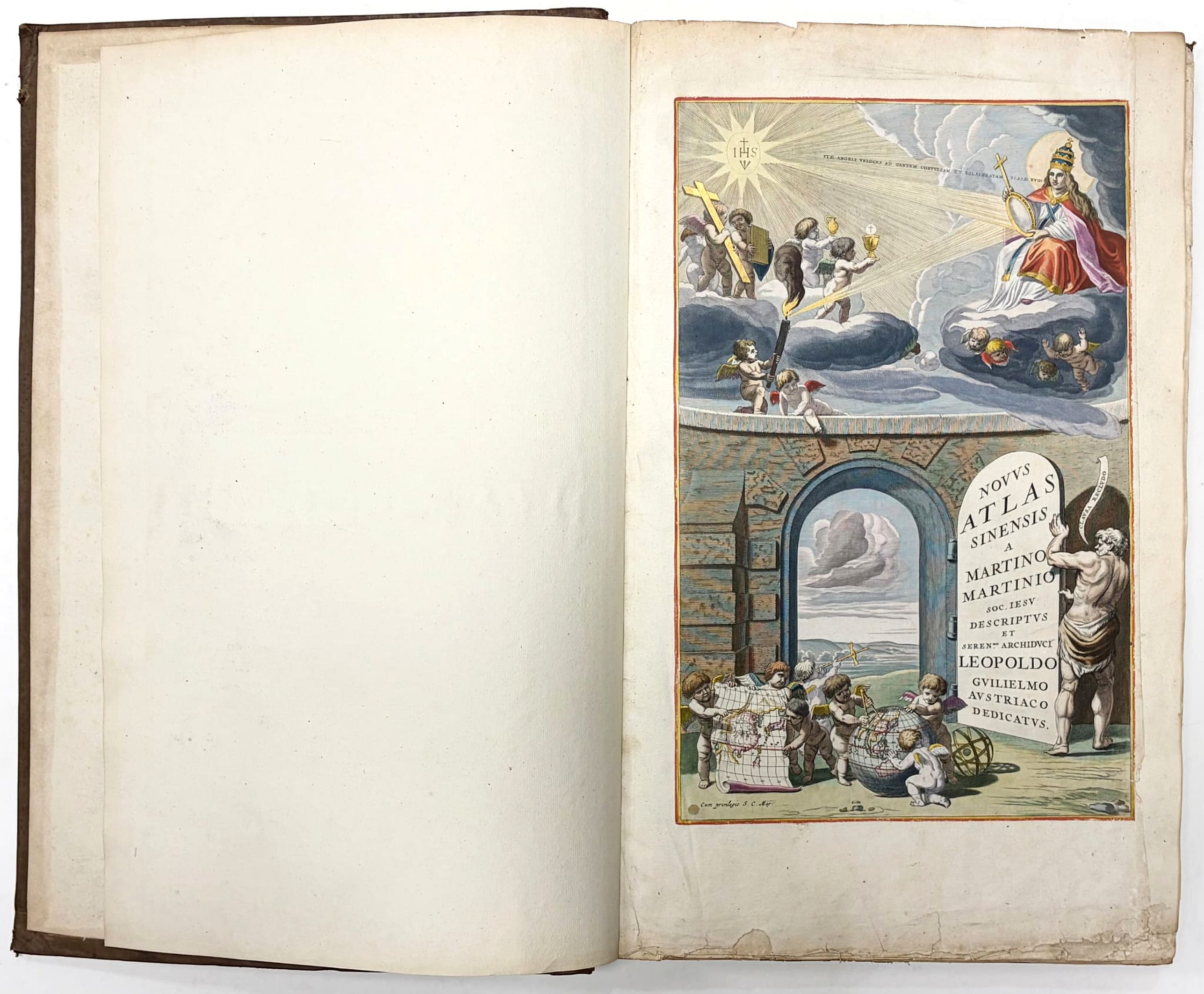
"The maps are noteworthy not only for their accuracy, remarkable for the time, but also for their highly decorative cartouches featuring vignettes depicting regional Chinese dress, activities, and animals. In addition, it is one of the first true Sino-European publications, based on Chinese land surveys but presenting geographic data in a highly visual European cartographic format". - Reed & Demattè.The title page has a facade with an opening giving a view of a landscape. In the foreground putti with a map and a globe, both of which exhibit a map of China.
The publication of the atlas of China seems to owe more to coincidence than to planning. In 1654, in the foreword to the Dutch edition of the atlas of Scotland, Joan Blacu announced that he was preparing town books of Italy, a volume of charts, and a volume of historical maps, and that these were delayed. But while he was working on these volumes, wrote Blaeu.
Father Martinus Martini had come from the Indies, bringing with him his sketches and descriptions of the Chinese empire. Martini persisted in his attempt to have Blaeu engraved and published these, so Blacu postponed the work on the other volumes to prepare the atlas of China, and published it about a year later.
Martinus Martini (1614-1661) began working in 1642 as a Jesuit missionary in various provinces of China. When he was ordered to Rome in 1651, he took with him more than 50 Chinese books and maps, among them a copy of the manuscript atlas of the Chinese provinces by Zhu Siben, compiled in 1311/12, with revisions from the printed atlas by Lo Hongxian (1555). Martini's ship was captured by the Dutch and brought to Java. Martini was sent to Amsterdam where he arrived in 1654. During the voyage to Europe aboard the Dutch East-Indiamen, Martini made a Latin translation of the text and wrote his own description of China.
In 1659, Joan Blacu published the Latin translation, titled Sinicae historiae decas prima, separately without maps. The text in Blaeu's atlas of China is Martini's own account, written in the first person, of the geography and history, the manners and customs of the Chinese empire and its peoples.
Martini's atlas of China includes the following parts:
1. Engraved title page
2. Letter press title page (Edition B according van der Krogt.
3. Svmma Previlegii Ferdinandi III.
4. A general map of China (map 1 -missing)
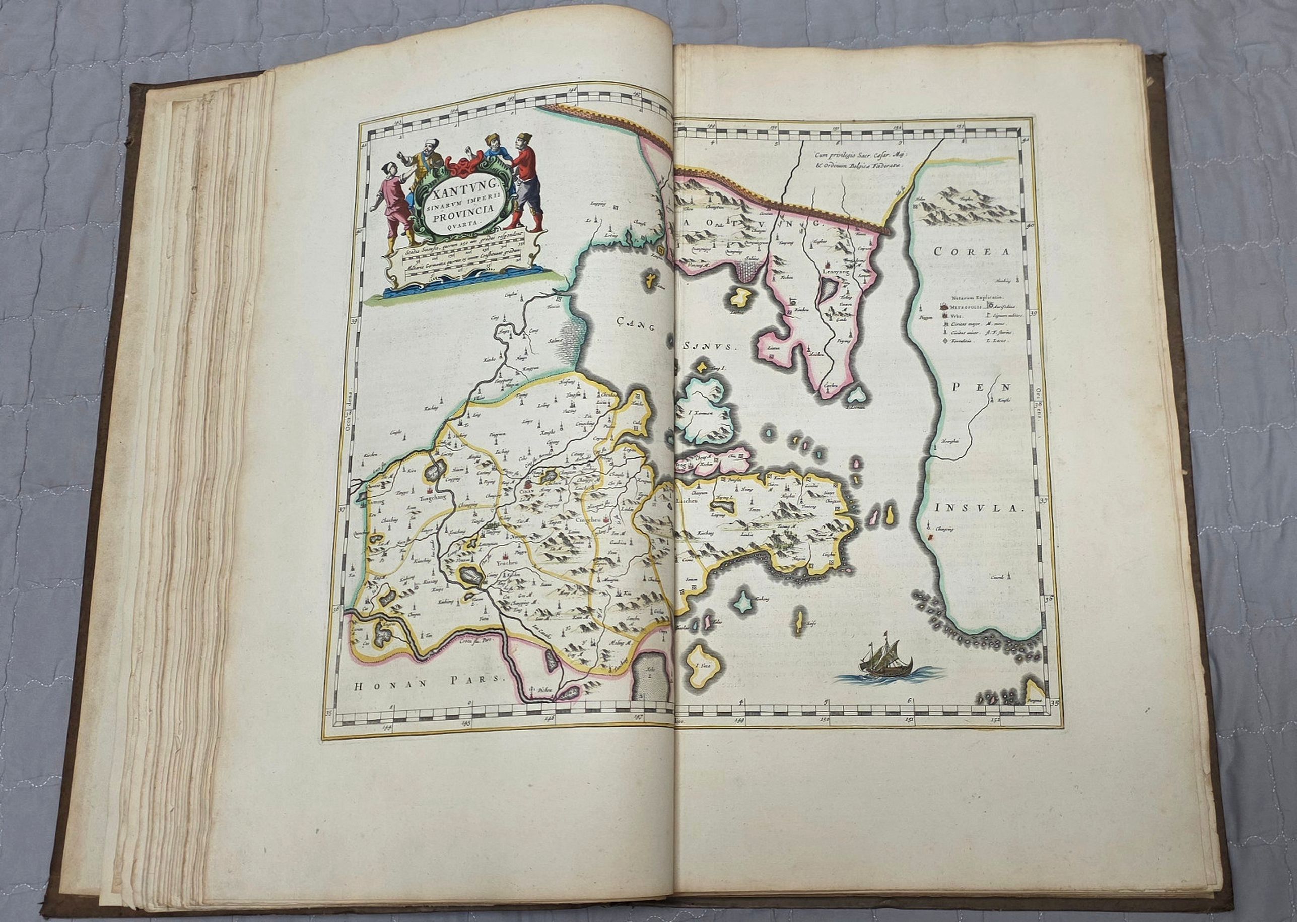
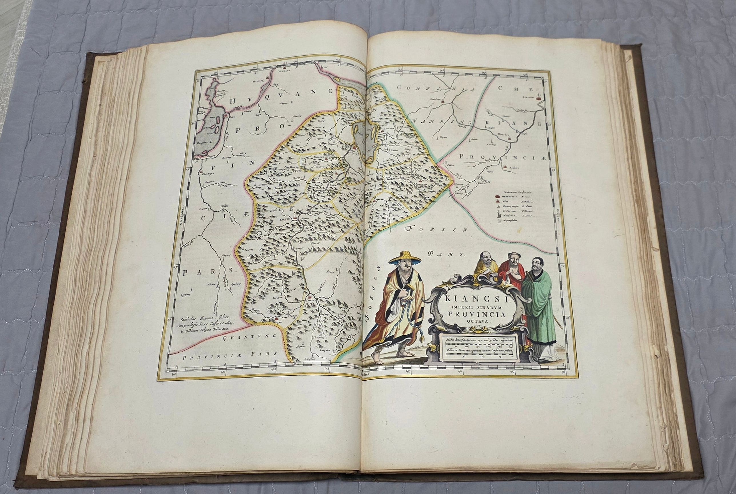
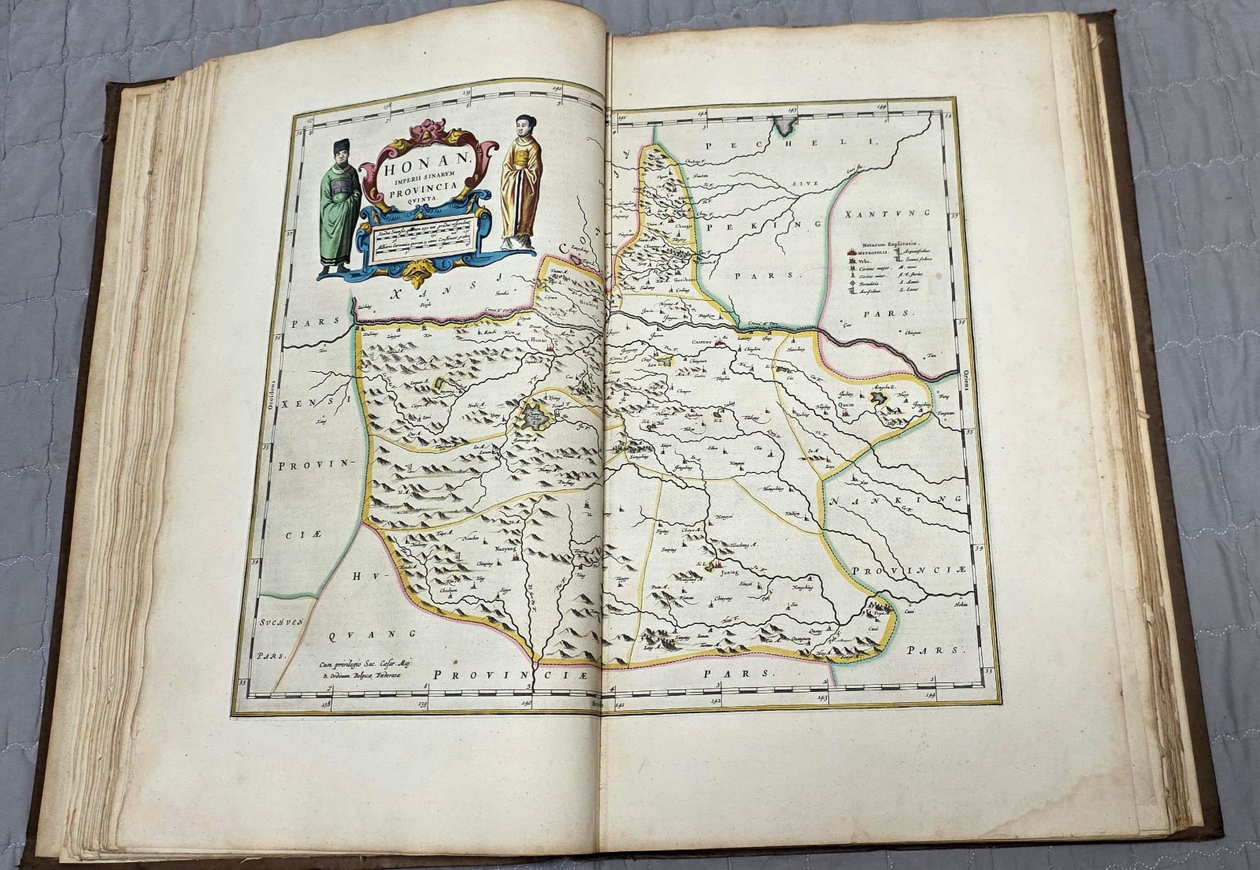
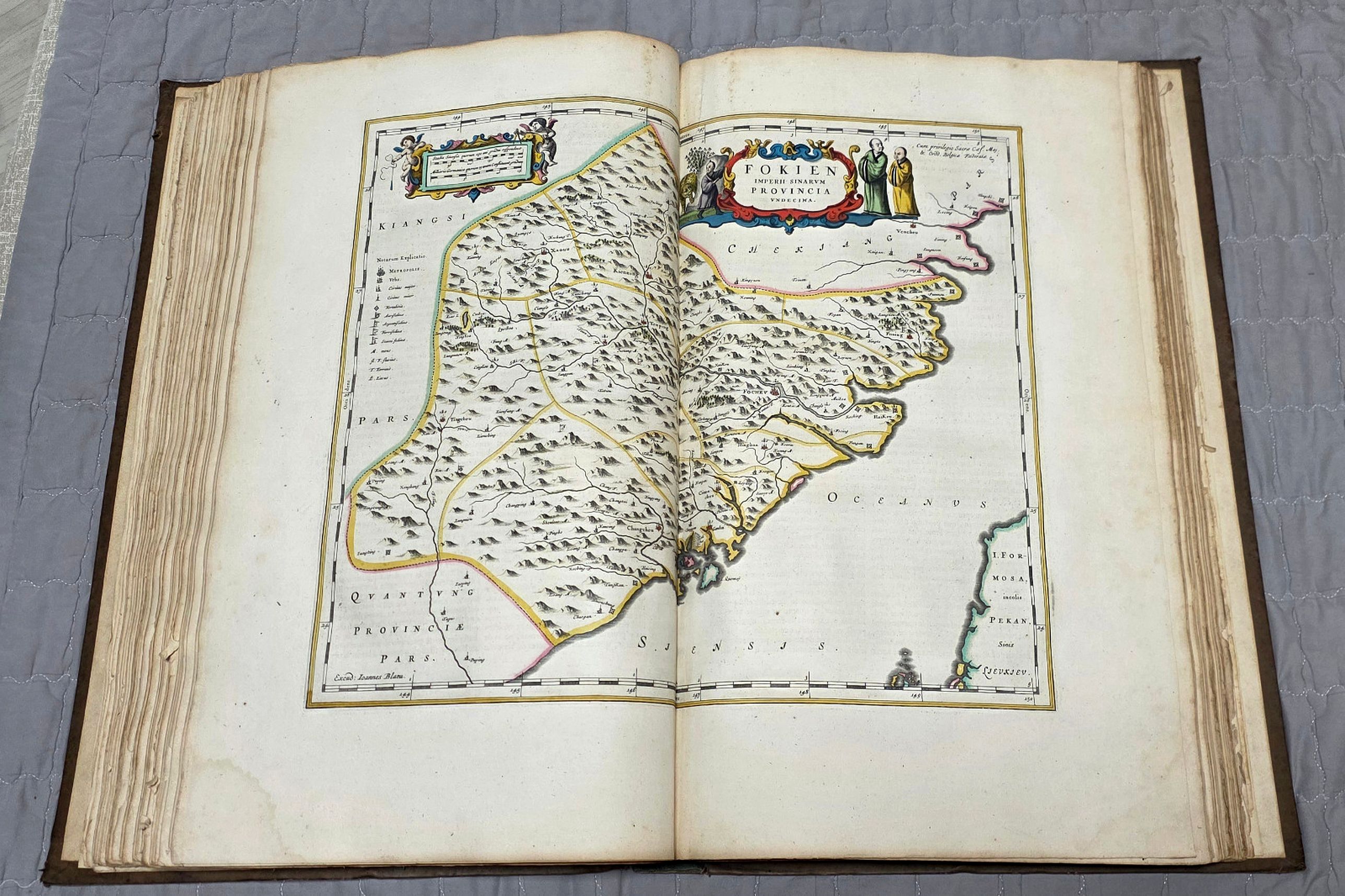
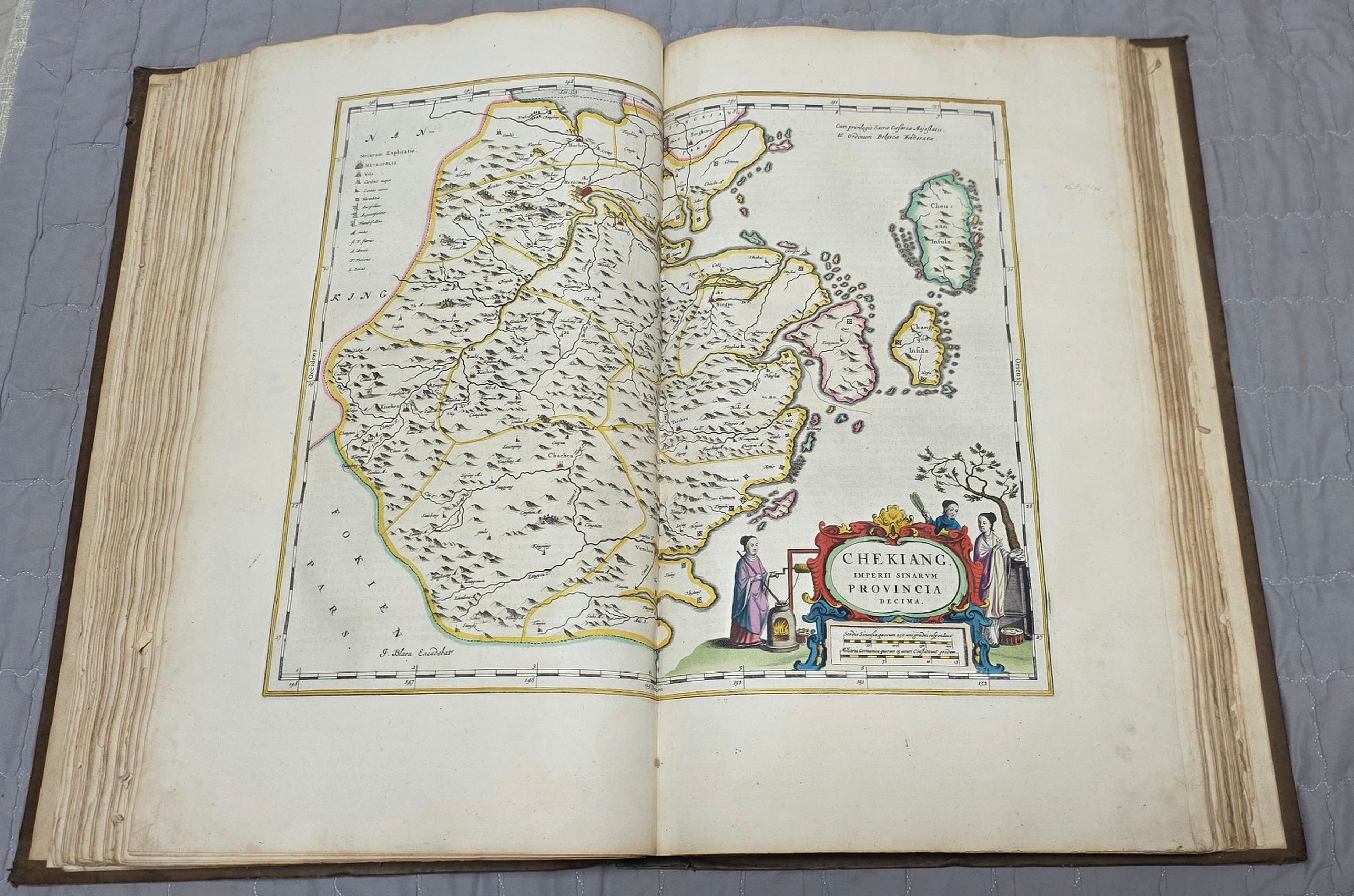
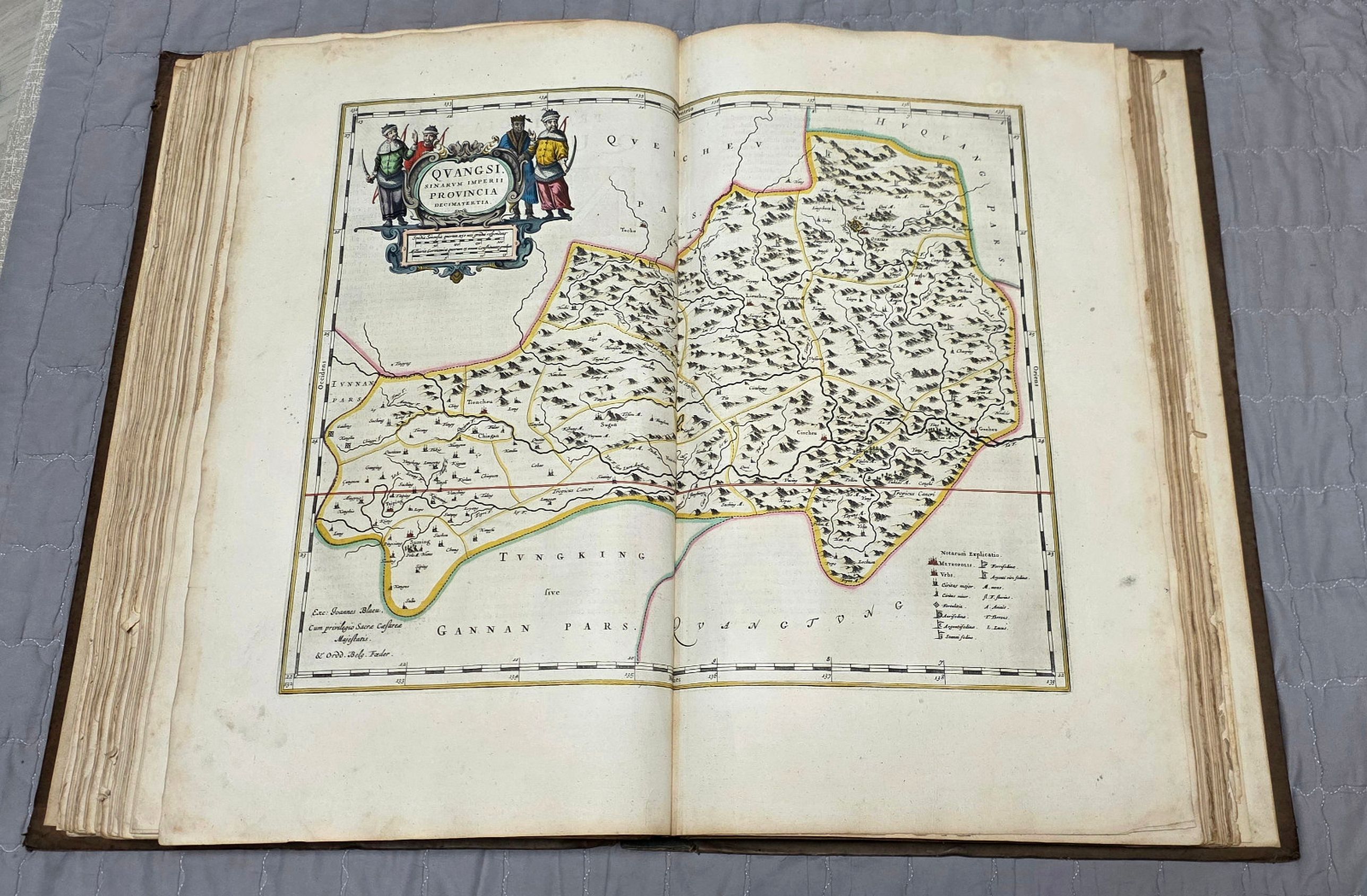
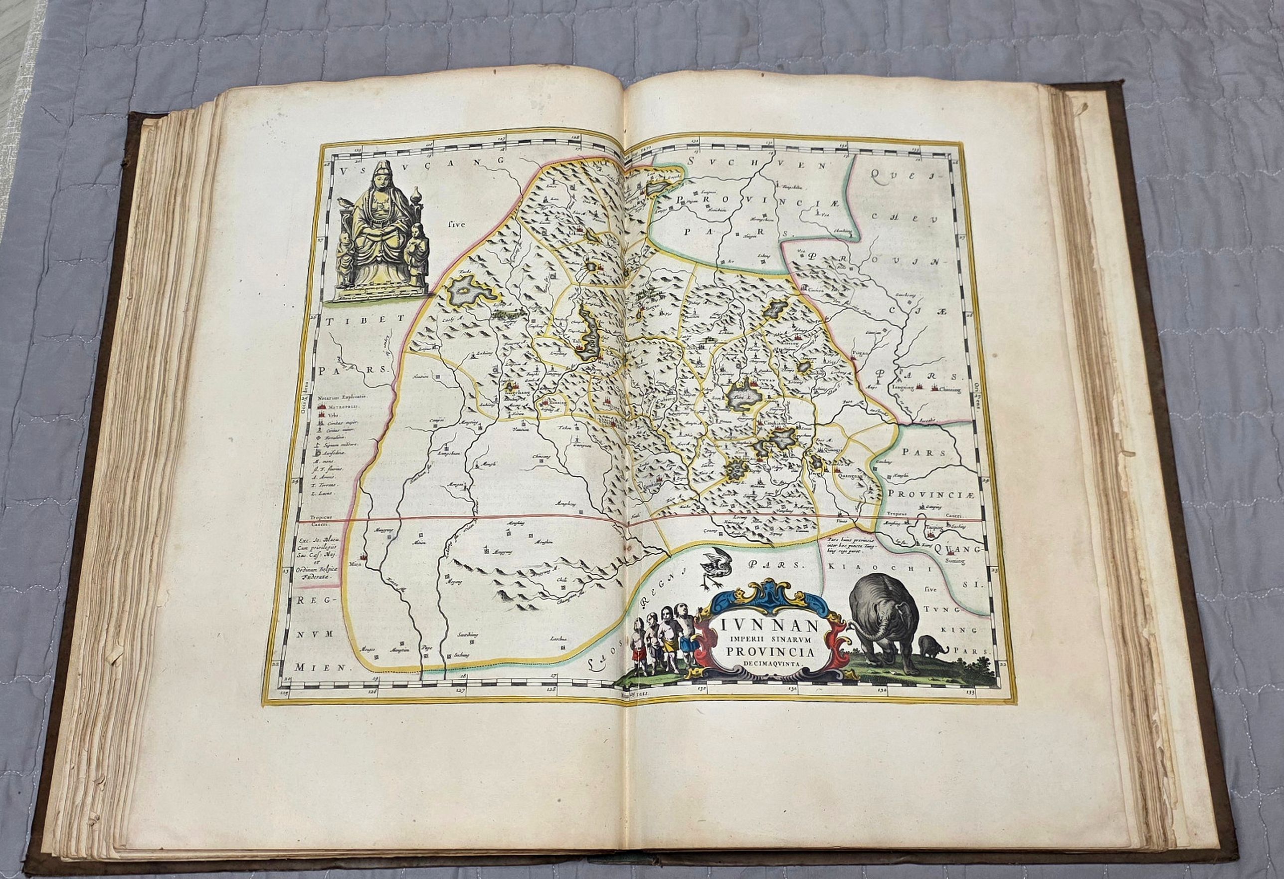
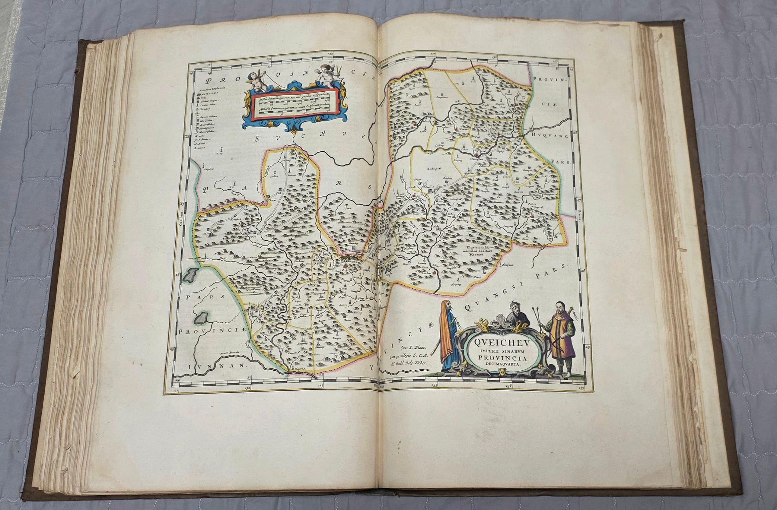
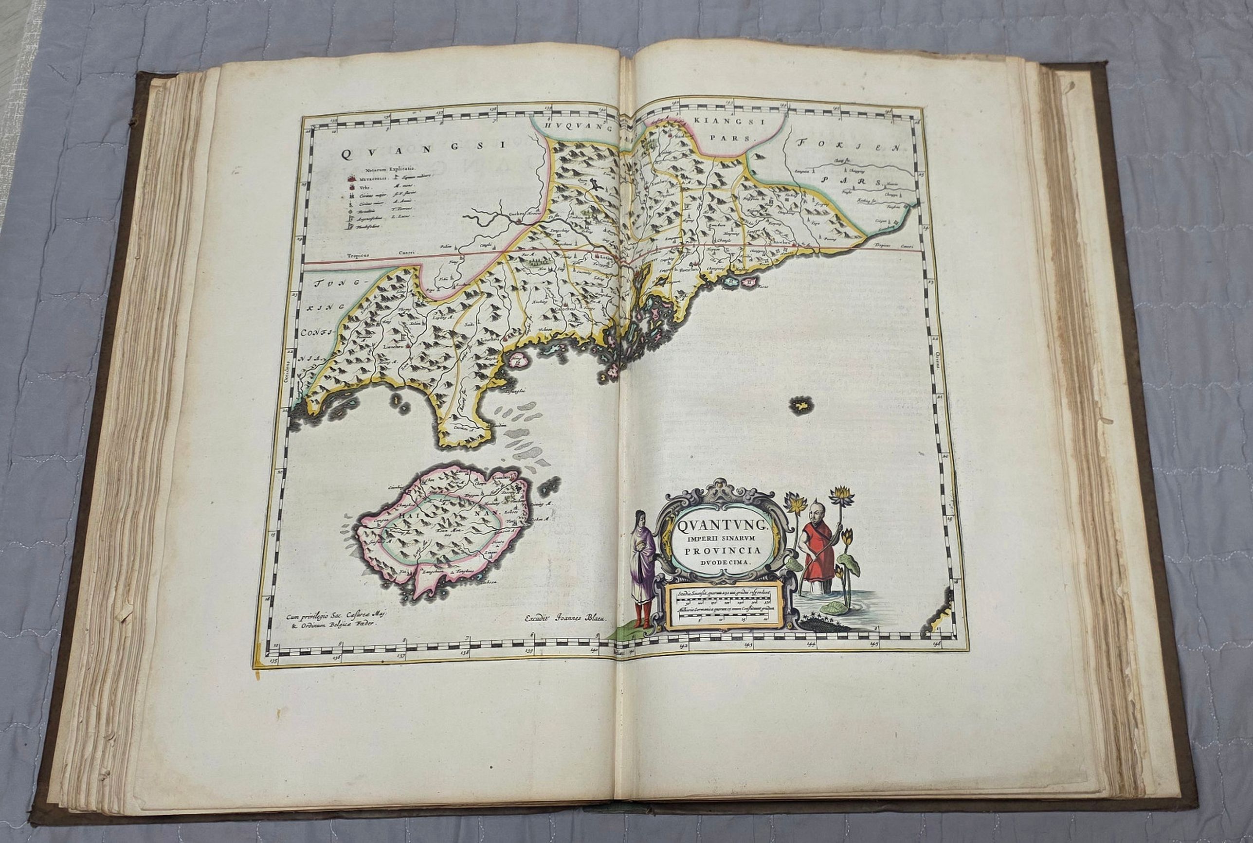
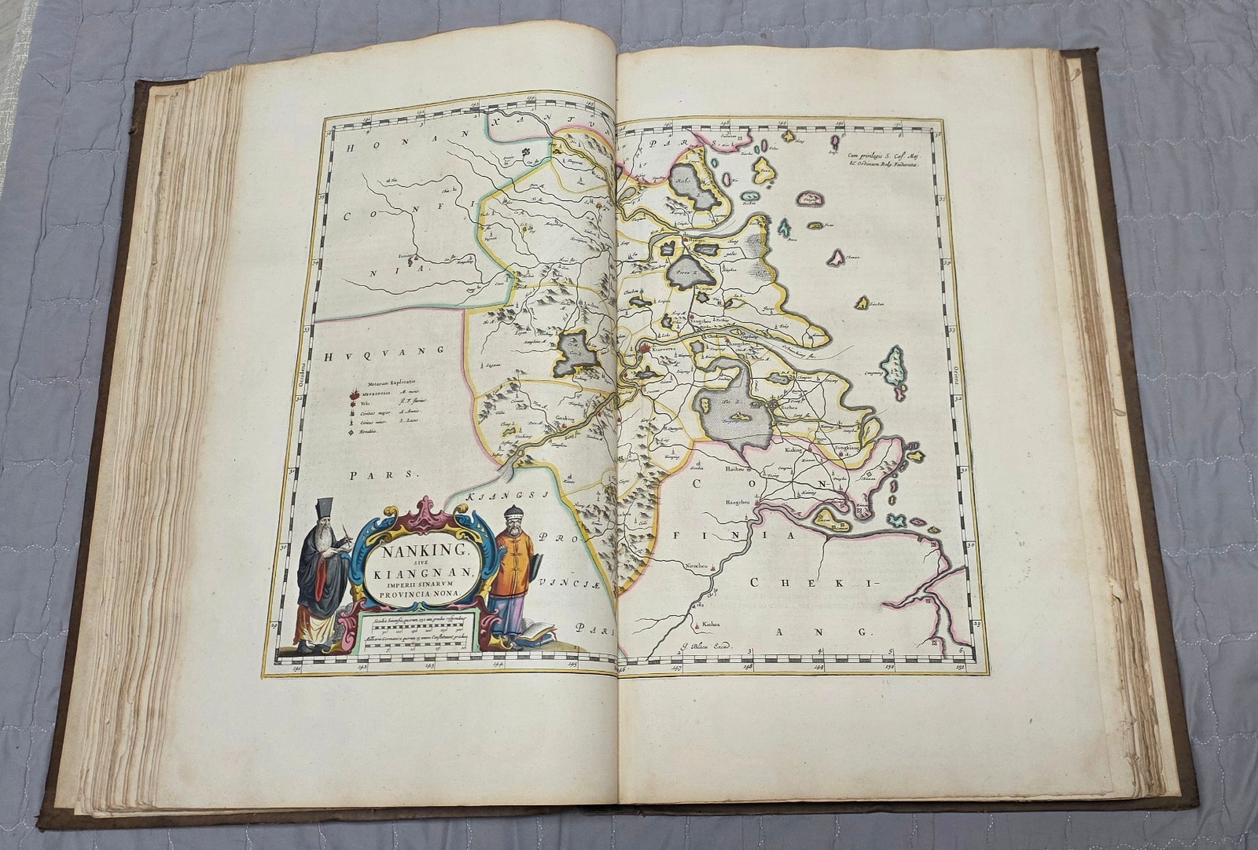
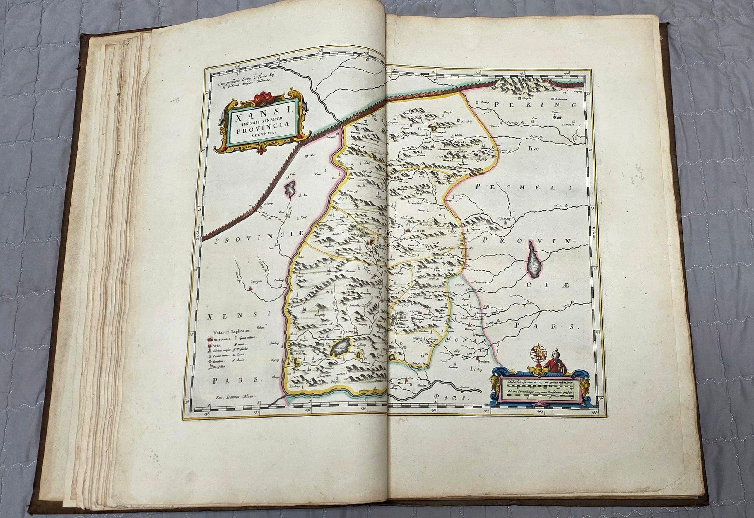
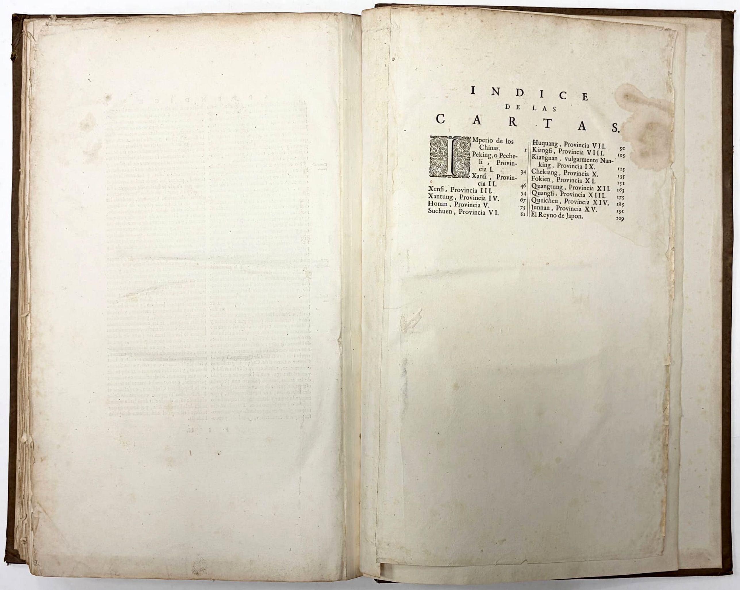
5. A geographical description of the 15 provinces of China, each description preceded by a map of that province, maps 2-16; Pecheli Sive Peking (missing), Xansi, p.46.- Xensi, p.54.- Xantung, p.67.- Honan, p.75.- Suchuen, p.81.- Huquang, p.91.- Kiangsi, p.105.- Nanking, p.115.- Chekiang, p.35.- Nanking, p.115.- Fokien, p.151.- Quantung, p.163.- Quang.
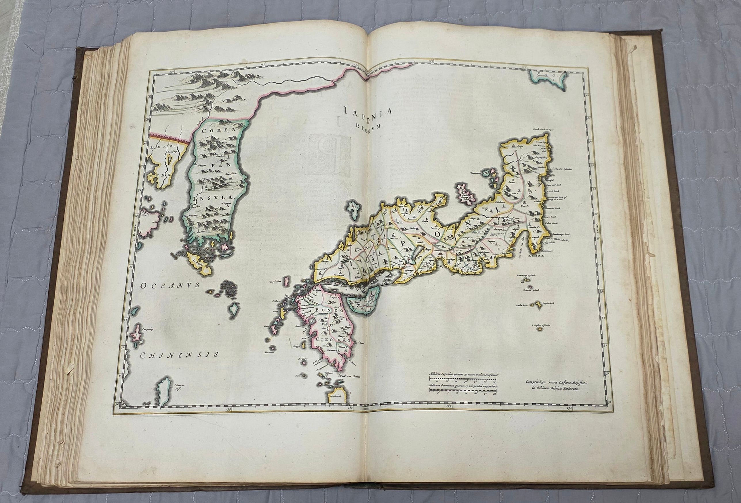
6. A geographical description of Japan with a map of Japan and Korea. (map 17).
7. Historiia De La Gyerra De Los Tartoros
8. A supplement to the geographical description by Jacob Golius, "Addiciones Sobre El Reyno Del Catay"
Peter van der Krogt list only four known examples in London, Madrid, Rotterdam, Washington. The map of Pecheli Sive Peking also wanting in the Madrid copy.
The atlas of China was published by Joan Blaeu in five different languages: Latin, French, Dutch, German, and Spanish. It was published separately and added as the sixth volume to the Theatrum Orbis Terrarum, the only difference being in the engraved title page. Title page 2:26B, was used for the separate editions of the atlas. The upper part has an allegory. Both title pages have the title of the atlas and the name of the author in Latin, but, strangely enough, the name of the publisher does not appear on the title page or anywhere else in the volume.
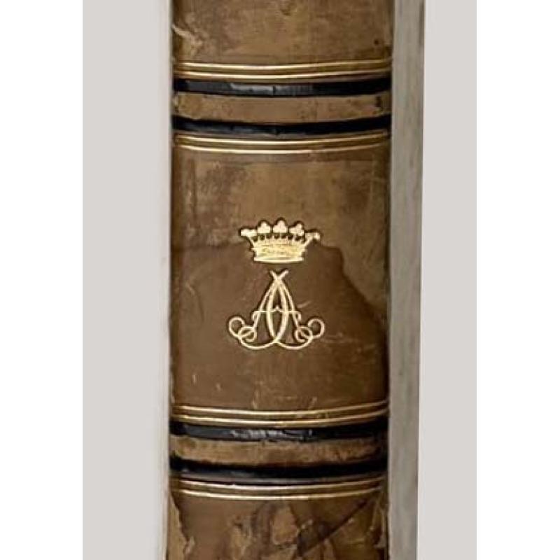
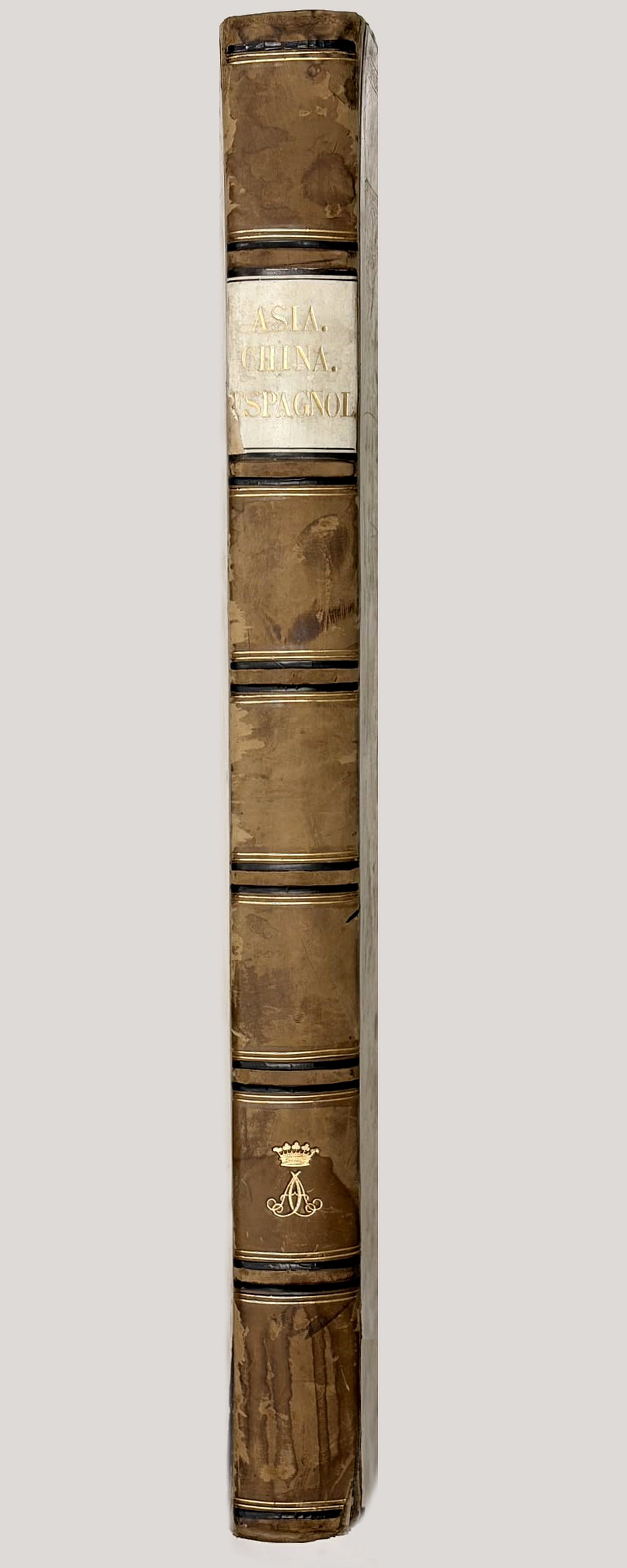
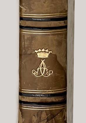
Provenance: George Douglas Campbell With gilded crowned A.A. monogram on spine. Christies, London, Sale 5685, 30th October 1996. Valuable Architecture, Atlases and Natural History.
George Douglas Campbell (1823-1900), who was an important Victorian scientific aristocrat. The Victorian scientific aristocrats, were known to be anything but passive. Not only was Argyll a knowledge maker in his own
right, I argue, but he also acted as a key facilitator, or broker, in knowledge networks dedicated to scientific and industrial advance across Britain and its growing empire.
At the time of the Royal Indian Engineering College (1871 – 1906) foundation, Argyll was Secretary of State for India.
George Douglas Campbell is known for his publications “The peer and the prophet: being the Duke of Argyll's article on "The prophet of San Francisco," and the reply of Henry George entitled, "The reduction to
iniquity". “India Under Dalhousie And Canning” (1865) is a historical book written by George Douglas Campbell in 1865. The book provides a comprehensive account of the British rule in India during the tenure of Lord Dalhousie and Lord Canning. The author delves into the political, social, and economic aspects of the British
administration in India during this period .The book starts with an introduction to the East India Company and its early history in India.
Reference: Koeman Bl 60 A. / v.d.Krogt Koemans Atlantes Neerlandici, vol. II; page 314-315, ref.:2:541.
There is only one edition of the Spanish text edition of China. This is the first western atlas of China, including sixteen engraved maps of Chinese subjects, and one general map of Japan, all in beautiful original outline hand-color.
The present work is based on the surveying and compiling work of Father Martinus Martini, the Jesuit Superior of Hangzhou.
"The maps are noteworthy not only for their accuracy, remarkable for the time, but also for their highly decorative cartouches featuring vignettes depicting regional Chinese dress, activities, and animals. In addition, it is one of the first true Sino-European publications, based on Chinese land surveys but presenting geographic data in a highly visual European cartographic format". - Reed & Demattè.
The title page has a facade with an opening giving a view of a landscape. In the foreground putti with a map and a globe, both of which exhibit a map of China.
The publication of the atlas of China seems to owe more to coincidence than to planning. In 1654, in the foreword to the Dutch edition of the atlas of Scotland, Joan Blacu announced that he was preparing town books of Italy, a volume of charts, and a volume of historical maps, and that these were delayed. But while he was working on these volumes, wrote Blaeu.
Father Martinus Martini had come from the Indies, bringing with him his sketches and descriptions of the Chinese empire. Martini persisted in his attempt to have Blaeu engraved and published these, so Blacu postponed the work on the other volumes to prepare the atlas of China, and published it about a year later.
Martinus Martini (1614-1661) began working in 1642 as a Jesuit missionary in various provinces of China. When he was ordered to Rome in 1651, he took with him more than 50 Chinese books and maps, among them a copy of the manuscript atlas of the Chinese provinces by Zhu Siben, compiled in 1311/12, with revisions from the printed atlas by Lo Hongxian (1555). Martini's ship was captured by the Dutch and brought to Java. Martini was sent to Amsterdam where he arrived in 1654. During the voyage to Europe aboard the Dutch East-Indiamen, Martini made a Latin translation of the text and wrote his own description of China.
In 1659, Joan Blacu published the Latin translation, titled Sinicae historiae decas prima, separately without maps. The text in Blaeu's atlas of China is Martini's own account, written in the first person, of the geography and history, the manners and customs of the Chinese empire and its peoples.
Martini's atlas of China includes the following parts:
1. Engraved title page
2. Letter press title page (Edition B according van der Krogt.
3. Svmma Previlegii Ferdinandi III.
4. A general map of China (map 1 -missing)
5. A geographical description of the 15 provinces of China, each description preceded by a map of that province, maps 2-16; Pecheli Sive Peking (missing), Xansi, p.46.- Xensi, p.54.- Xantung, p.67.- Honan, p.75.- Suchuen, p.81.- Huquang, p.91.- Kiangsi, p.105.- Nanking, p.115.- Chekiang, p.35.- Nanking, p.115.- Fokien, p.151.- Quantung, p.163.- Quang.
6. A geographical description of Japan with a map of Japan and Korea. (map 17).
7. Historiia De La Gyerra De Los Tartoros
8. A supplement to the geographical description by Jacob Golius, "Addiciones Sobre El Reyno Del Catay"
Peter van der Krogt list only four known examples in London, Madrid, Rotterdam, Washington. The map of Pecheli Sive Peking also wanting in the Madrid copy.
The atlas of China was published by Joan Blaeu in five different languages: Latin, French, Dutch, German, and Spanish. It was published separately and added as the sixth volume to the Theatrum Orbis Terrarum, the only difference being in the engraved title page. Title page 2:26B, was used for the separate editions of the atlas. The upper part has an allegory. Both title pages have the title of the atlas and the name of the author in Latin, but, strangely enough, the name of the publisher does not appear on the title page or anywhere else in the volume.
Provenance: George Douglas Campbell With gilded crowned A.A. monogram on spine. Christies, London, Sale 5685, 30th October 1996. Valuable Architecture, Atlases and Natural History.
George Douglas Campbell (1823-1900), who was an important Victorian scientific aristocrat. The Victorian scientific aristocrats, were known to be anything but passive. Not only was Argyll a knowledge maker in his own
right, I argue, but he also acted as a key facilitator, or broker, in knowledge networks dedicated to scientific and industrial advance across Britain and its growing empire.
At the time of the Royal Indian Engineering College (1871 – 1906) foundation, Argyll was Secretary of State for India.
George Douglas Campbell is known for his publications “The peer and the prophet: being the Duke of Argyll's article on "The prophet of San Francisco," and the reply of Henry George entitled, "The reduction to
iniquity". “India Under Dalhousie And Canning” (1865) is a historical book written by George Douglas Campbell in 1865. The book provides a comprehensive account of the British rule in India during the tenure of Lord Dalhousie and Lord Canning. The author delves into the political, social, and economic aspects of the British
administration in India during this period .The book starts with an introduction to the East India Company and its early history in India.
Reference: Koeman Bl 60 A. / v.d.Krogt Koemans Atlantes Neerlandici, vol. II; page 314-315, ref.:2:541.
FAQ - Guarantee - Shipping
Buying in the BuyNow Gallery
This item is available for immediate purchase when a "Add to Cart" or "Inquire Now" button is shown.
Items are sold in the EU margin scheme
Payments are accepted in Euros or US Dollars.
Authenticity Guarantee
 We provide professional descriptions, condition report (based on 45 years experience in the map business)
Paulus Swaen warrants the authenticity of our items and a certificate of authenticity is provided for each acquired lot.
Condition and Coloring
We indicate the condition of each item and use our unnique HiBCoR grading system in which four key items determine a map's value: Historical Importance, Beauty, Condition/Coloring and Rarity.
Color Key
We offer many maps in their original black and white condition. We do not systematically color-up maps to make them more sellable to the general public or buyer.
Copper engraved or wood block maps are always hand colored. Maps were initially colored for aesthetic reasons and to improve readability. Nowadays, it is becoming a challenge to find maps in their original colors and are therefor more valuable.
We use the following color keys in our catalog:
Original colors; mean that the colors have been applied around the time the map was issued.
Original o/l colors; means the map has only the borders colored at the time of publication.
Colored; If the colors are applied recently or at the end of the 20th century.
Read more about coloring of maps [+]
Shipping fee
A flat shipping fee of $ 30 is added to each shipment by DHL within Europe and North America. This covers : International Priority shipping, Packing and Insurance (up to the invoice amount).
Shipments to Asia are $ 40 and rest of the world $50
We charge only one shipping fee when you have been successful on multiple items or when you want to combine gallery and auction purchases.
Read more about invoicing and shipping
FAQ
Please have a look for more information about buying in the BuyNow gallery
Many answers are likely to find in the general help section.
Virtual Collection
![]()
With Virtual Collection you can collect all your favorite items in one place. It is free, and anyone can create his or her Virtual map collection.
Unless you are logged in, the item is only saved for this session. You have to be registed and logged-in if you want to save this item permanently to your Virtual Collection.
Read More[+]
Register here, it is free and you do not need a credit card.
Add this item to
Virtual Collection
or click the following link to see my Virtual Collection.
| Digital Image Download | |
|
Paulus Swaen maintains an archive of most of our high-resolution rare maps, prints, posters and medieval manuscript scans. We make them freely available for download and study. Read more about free image download |
Click the image for a free small image download. |
In accordance with the EU Consumer Rights Directive and habitually reside in the European Union you have the right to cancel the contract for the purchase of a lot, without giving any reason.
The cancellation period will expire 14 calendar days from the day after the date on which you or a third party (other than the carrier and indicated by you) acquires, physical possession of the lot. To exercise the right to cancel you must inform Paulus Swaen Inc, of your decision to cancel this contract by a clear statement (e.g. a letter sent by post, or e-mail (amsterdam@swaen.com).
To meet the cancellation deadline, it is sufficient for you to send your communication concerning your exercise of the right to cancel before the cancellation period has expired.
