Browse Listings
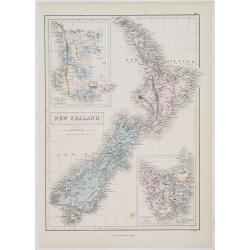
New Zealand.
A detailed lithographed map of New Zealand. With in upper left corner inset-map of Western Australia and in lower right hand corner a map of Van Diemens Land. Published b...
- $100 / ≈ €85
Date: Edinburg, 1874
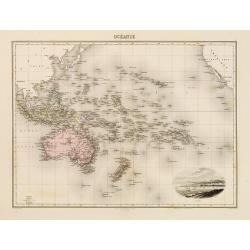
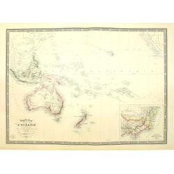
Océanie.
In lower right hand corner a view of Nouméa. Showing the Pacific including California. Engraved by L.Smith.
- $90 / ≈ €76
Date: Paris, 1874
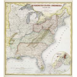
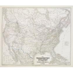
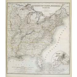
Die Vereinigten Staten von Nordamerika (Ostlicher theil).
Detailed map of eastern part of the United states until the border of Texas. In lower right hand corner inset map of New York Bay, including, NY, Newark, Staten Island.Th...
- $450 / ≈ €382
Date: Weimar, 1874
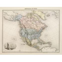
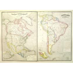
Amérique du Nord.
Decorative map of Northern America from Géographie Universelle, Atlas Migeon. published by J. Migeon. Nice engraving at the lower left hand of New York with the Statue o...
Date: Paris, 1874
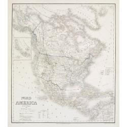
Die Vereinigten Staten von Nordamerika nebst Canada.
Large and very detailed German map issued before the outbreak of the Civil War. It covers the United States, parts of Canada, and Mexico. The states and territories are s...
- $400 / ≈ €340
Date: Weimar, 1874
Nord America mit Westindien.
Detailed map of North America. With a color key indicating US, English, French, Dutch, Spanish, Portuguese, Danish possessions in the region with original outline color d...
- $300 / ≈ €255
Date: Weimar, 1874
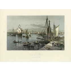
City of Boston.
A handsome mid 19th century panoramic view of the city of Boston as seen from the southern part of it's harbor. Many monuments are clearly visible, including the State Ho...
- $250 / ≈ €212
Date: New York, 1872-1874
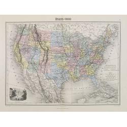
Etats-Unis.
Decorative map of the United States from Géographie Universelle, Atlas Migeon. Oklahoma is Indian Territory with Public Lands in the panhandle. With an engraving lower l...
- $75 / ≈ €64
Date: Paris, 1874
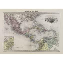
Amérique Centrale.
Decorative map of Central America from Géographie Universelle, Atlas Migeon. With an inset map of the Isthmus of Panama lower left corner and a panoramic view of Mexico ...
Date: Paris, 1874
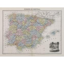
Espagne et Portugal.
A decorative map of Spain and Portugal from Géographie Universelle, Atlas Migeon. With an engraving of the Alhambra in the lower right corner. Published by J. Migeon. Fr...
- $35 / ≈ €30
Date: Paris, 1874
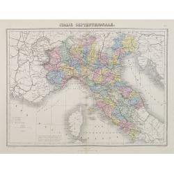
Italie Septentrionale.
A decorative map of northern Italy from Géographie Universelle, Atlas Migeon, published by J. Migeon.From one of the last decorative atlases published in the 19th centur...
- $25 / ≈ €21
Date: Paris, 1874
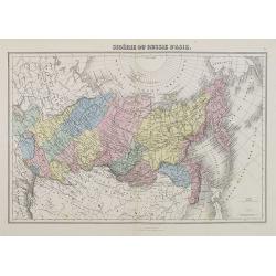
Sibérie ou Russie d'Asie.
A decorative map of Siberia from Géographie Universelle, Atlas Migeon. published by J. Migeon.From one of the last decorative atlases published in the 19th century.
Date: Paris, 1874
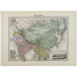
Inde, Chine, Indo-Chine et Japon.
A decorative map of India, China, Japan and East Asia from Géographie Universelle, Atlas Migeon, published by J. Migeon. In lower right corner a view of Calcutta and to ...
Date: Paris, 1874

Carte du Kouy-Tchéou.
Detailed map of Guizhou Province prepared by Mgr. Faurie and other sources supplied by missionaries. Published in "Les Missions Catholique". Engraved by P. Méa...
Date: Lyon, c.1874
![Carte du Tche-Kiang. [ Zhejiang province ]](/uploads/cache/30921-250x250.jpg)
Carte du Tche-Kiang. [ Zhejiang province ]
Map of Tche Kiang, prepared by Bishop Edmond-François Guierry, C.M. (Vicar Apostolic of Zhejiang, China) after sources supplied by missionaries. Published in "Les M...
Date: Paris, 1874

Nieuwe kaart van het Koningrijk der Nederlanden. . .
Uncommon map of the Netherlands prepared by J.S. Smulders and P. H. Witkamp and lithographed by Z.M. den Koning in the Hague. Dated.Showing The Kingdom of the Netherlands...
Date: The Hague, 1874
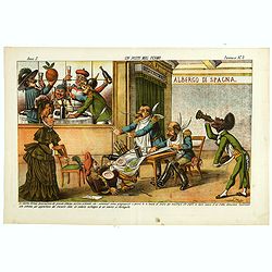
Un Posto mal fermo. Papagallo No. 5. Anno II.
Design by Augusto Grossi. Taken from the Italian satirical newspaper Il Papagallo, a satirical magazine founded in January 1873 by Augusto Grossi (1835-1919), which speci...
Date: Bologne, 1874
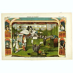
Theatre du Trianon. Papagallo No. 2. Anno II.
Design by Augusto Grossi. Taken from the Italian satirical newspaper Il Papagallo, a satirical magazine founded in January 1873 by Augusto Grossi (1835-1919), which speci...
Date: Bologne, 1874
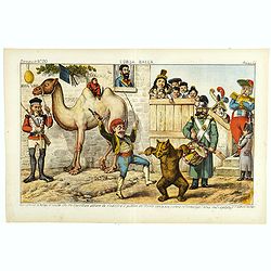
L'Orsa Balla. Papagallo No. 30. Anno II.
Design by Augusto Grossi. Taken from the Italian satirical newspaper Il Papagallo, a satirical magazine founded in January 1873 by Augusto Grossi (1835-1919), which speci...
Date: Bologne, 1874

I diritti da discutersi al congresso di Brusselle. Papagallo No. 32. Anno II.
Design by Augusto Grossi. Taken from the Italian satirical newspaper Il Papagallo, a satirical magazine founded in January 1873 by Augusto Grossi (1835-1919), which speci...
Date: Bologne, 1874
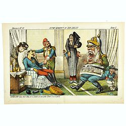
Ultimi momenti di Don Carlos. Papagallo No. 33. Anno II.
Design by Augusto Grossi. Taken from the Italian satirical newspaper Il Papagallo, a satirical magazine founded in January 1873 by Augusto Grossi (1835-1919), which speci...
Date: Bologne, 1874

La Pieuvre Germanique.
Scarce lithographed plate not dated, by Eugène Danzanvilliers, printed by Grandremy in Paris. The plate listed by Adhemar is dated 1874. Eugène Danzanvilliers was a dra...
Date: Paris, 28 Quai de la Rapée, c.1874
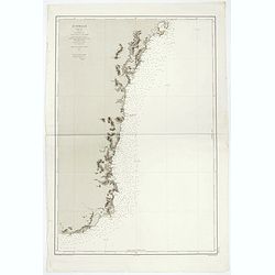
Australie (Côte Est) Feuille N°10 Partie comprise entre La Baie Jervis et le Cap Everard . . .
Large French sea chart featuring the eastern coast of Australia. Engraved by J.Millian. The chart is based on surveys by the British Captn. F.W. Sidney, Staff Comr., H.J....
Date: Paris, 1874

La pericolante ostinata. Papagallo No. 20 Anno II.
Design by Augusto Grossi. Taken from the Italian satirical newspaper Il Papagallo, a satirical magazine founded in January 1873 by Augusto Grossi (1835-1919), which speci...
Date: Bologne, 1874
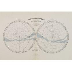
Planisphère Célèste.
Showing the southern and northern celestial hemispheres from Géographie Universelle, Atlas Migeon. Published by J. Migeon. From one of the last decorative atlases publis...
Date: Paris, 1874
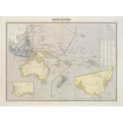
Océanie dresée par C.V.Monin.
Fine and uncommon map including Australia, New Zealand, Indonesia, with inset maps of New Zealand, Victoria/New South Wales and Western Australia including Albany and Per...
- $150 / ≈ €127
Date: Paris, 1875
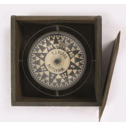
Compass.
A very nicely crafted sloop compass in original box. The compass is gimbaled and is executed in beautiful red copper. Made and signed by F.J. Kloos & Son of Rotterdam...
Date: Rotterdam, 1850-1875

Sint Catharinakerk te Eindhoven.
Uncommon woodblock engraving of St.Catharina church of Eindhoven, built by the well-known architect P.Cuijpers. Published in Katholieke Illustratie.The "katholieke i...
Date: 'sHertogenbosch, Henri Bogaerts, 1875
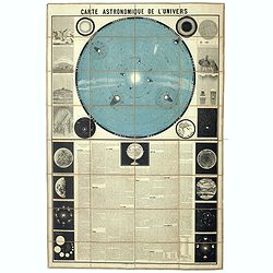
Carte Astronomique de L'Univers.
A large and decorative, informative chart illustrating and describing the Solar System, backed by the stars, printed in blue and black, surrounded by further 17 vignette ...
Date: Paris, 1875
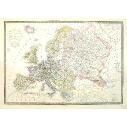
Nouvelle carte physique et politique de l'Europe. Les limites d'états.
A very large, uncommonly updated version of the map of Europe, prepared by H. Brué and updated by A. Vuillemin. In the lower margin, "Nouvelle edition" and a d...
Date: Paris, 1875
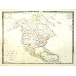
Nouvelle carte de l'Amérique Septentrionale et des iles qui en dépendent dressée par H. Brué. . .
Very large, highly detailed, and uncommon issue of the map of North and Central America (ca. 1:13,888,000) prepared by H. Brué and improved by A.Vuillemin. Showing main ...
- $500 / ≈ €425
Date: Paris, 1875

Histoire de la Guerre Civile en Amerique par M. Le Comte de Paris, Ancien Aide de Camp du General Mac Clellan (McClellan). ...
The maps are chromolithographs and offer a fascinating view of the Civil War battlegrounds. Vorzet made these 30 maps to accompany Louis Phillipe d'Orleans' (Comte de ...
Date: Paris. Michel Levy Freres, 1875

New York Ferry Boat. (Bac à vapeur de New York).
A very decorative print showing the New York Ferry Boat "Fulton," published by Currier & Ives. The Ferry boat "Fulton" sails to the right. A singl...
Date: New York, ca. 1875
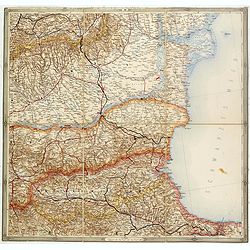
(Untitled map of western shores of the Black Sea, with Bulgaria, Roumenia.)
Untitled map of western shores of the Black Sea, with Bulgaria, Roumenia. The map has elaborate floral borders. Prepared by Josef Schlacher in Vienna and published by K.K...
- $150 / ≈ €127
Date: Vienna, K.K. Militär Geografisches Institut, 1875
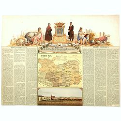
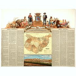
Provincia de Ciudad-Real.
Chromolithography published in "Atlas geográfico histórico de las Provincias de España". Map made by J. Reinoso, Dedicated to Excmo. Sr. Dn. Baldomero Espart...
- $120 / ≈ €102
Date: Madrid, c. 1875
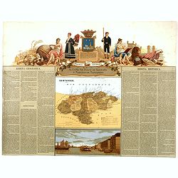
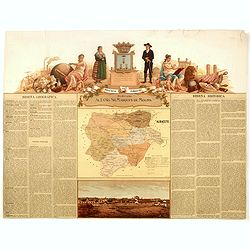
Provincia de Santander.
Chromolithography published in "Atlas geográfico histórico de las Provincias de España". Map engraved by J. Reinoso, Dedicated to Excmo. Sr. Duque de Santona...
- $120 / ≈ €102
Date: Madrid, c. 1875
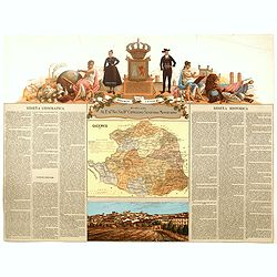
Provincia de Caceres.
Chromolithography published in "Atlas geográfico histórico de las Provincias de España". Map made by M. Vierge, Dedicated to Excmo. Sr. Dn. Cipriano Segundo ...
- $120 / ≈ €102
Date: Madrid, c. 1875
Provincia de Badajoz.
Chromolithography published in "Atlas geográfico histórico de las Provincias de España". Map engraved by M. Vierge, Dedicated to Ilmo. Sr. Dn. Vicente Barran...
- $120 / ≈ €102
Date: Madrid, c. 1875
Provincia de Albacete.
Chromolithography published in "Atlas geográfico histórico de las Provincias de España". Map made by M. Vierge, Dedicated to Ilmo. Sr. Dn. Vicente Barrantes....
- $60 / ≈ €51
Date: Madrid, c. 1875
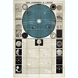
Carte Astronomique de L'Univers.
A large and decorative, informative chart illustrating and describing the Solar System, backed by the stars, printed in blue and black, surrounded by further 17 vignette ...
Date: Paris, 1875

Trop d'Appetit par A. Le Petit.
Dated in lower right dated "Le 9 juin 1875". The drawing is representing an alligator's jaw wearing a Prussian helmet, and about to chew a globe. Alfred Le Peti...
Date: Paris, 1875

Paris fashion plate. (164)
From Revue de la Mode. Gazette de la Famille.. Underneath the print are the names of the shops where the clothing's, perfumes, porcelains, flowers, etc., depicted in the ...
Date: Paris, 1875

Atlas der für den Weinbau Deutschlands und Oesterreichs werthvollsten Traubensorten. Mit genauer Beschreibung der Eigenschaften, Cultur-Methoden und des Schnittes...
Atlas der für den Weinbau Deutschlands und Oesterreichs werthvollsten Traubensorten. Mit genauer Beschreibung der Eigenschaften, Cultur-Methoden und des Schnittes, der A...
Date: Vienne, Wien, Faesy und Frick, 1873-1876
Die Vereinigten Staaten von Nordamerika (Ostlicher theil).
This is a 1876 example of C. Graf's map of the United States of America. The map covers the eastern part of the United States from eastern Texas to the Atlantic, extendin...
- $300 / ≈ €255
Date: Weimar, 1876
Nouvelle carte de l'Océanie dressée d'après les documents les plus récents par A. Vuillemin, géographe.
Very large, highly detailed and uncommon map of the Pacific with Australia and New Zealand, with inset map of "Partie de l'Australie (Nouvelle Galles du Sud) et Vict...
Date: Paris, 1876
Amérique septentrionale dressée par C.V. Monin. . . / Amérique méridionale. . .
Two maps on one sheet. North America to the left, shows major cities, political divisions, and areas of Indian habitation for North America and the West Indies and state ...
- $300 / ≈ €255
Date: Paris, c.1876
![Jules Verne. Le Tour du Monde en 80 jours. [Goose game board inspired by Jules Verne's novel Tour du Monde en 80 jours.]](/uploads/cache/44962-250x250.jpg)
Jules Verne. Le Tour du Monde en 80 jours. [Goose game board inspired by Jules Verne's novel Tour du Monde en 80 jours.]
This Goose game board is inspired by Jules Verne's novel whose boxes are illustrated with town views and figures and the center is occupied by a world map. Vignette illus...
- $1100 / ≈ €935
Date: Paris, 1876

Mapa geogra´fico de la mayor parte de la Ame´rica Meridional que contiene los paises por donde debe trazarse la li´nia divisoria que divida los dominios de Espan~a y Portugal. . .
Rare first edition of the map drawn by Francisco Requena (1743-1824) after his expedition to the Amazon in order to delineate the boundary between the Spanish and Portugu...
Date: Bourquin, F. Philadelphia, ca. 1876

Société de la Charité Maternelle à Paris. Plan de le ville de Paris, Divisé par Quartiers avec Nomenclature.
>Rare atlas de Paris dressé par E. Devrainne, divisé en 80 quartiers et colorié par Le Roux (Le Roux pinxit). Illustré d'une page de titre aux armes de Paris avec ...
Date: Imprimerie Mercier, Clichy, 1876

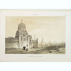
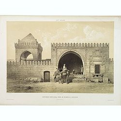
Tombeau de Soultan Qalaoûn.
Lithograph by Bernard Schmidt representing the tomb of sultan Ibn Qalaoun, founder of the mamluk dynasty during the 13th century. The tomb has some rich stained glass and...
Date: Paris, 1877
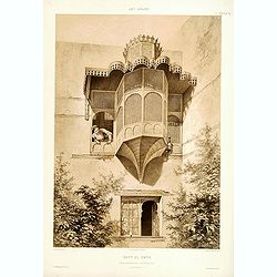
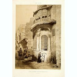
Beyt El-Emyr.
Lithograph by Mouilleron representing a young woman looking over a beautiful moucharabieh. From the author's "L'Art Arabe d'après les monuments du Kaire?". Emi...
Date: Paris, 1877

Mosquée de Mohammed Ben Qalaoûn. Details du Minaret Partie Inférieure. (XIVe. siècle)
Highly decorative lithography by Asselineau, showing architectural details of the minaret of Qalaoûn's mosque in Cairo. From the author's "L'Art Arabe d'après les ...
- $150 / ≈ €127
Date: Paris, 1877

Porte du Palais du Soultan Beybars. (XIIIe. siècle)
Highly decorative lithography by Ch. Fichot, showing the walled-up entrance of Sultan Beybars' palace. From the author's "L'Art Arabe d'après les monuments du Kaire...
Date: Paris, 1877

Tombeau d'un Emir. (XIIIe. siècle)
Highly decorative lithography by Ch. Fichot, representing the mausoleum of an emir. From the author's "L'Art Arabe d'après les monuments du Kaire". Emile Priss...
- $150 / ≈ €127
Date: Paris, 1877
Tombeau du Soultan Tarabey. (XVIe. siècle)
Highly decorative lithography by Ch. Fichot, representing Sultan Tarabey's mausoleum. From the author's "L'Art Arabe d'après les monuments du Kaire?". Emile Pr...
Date: Paris, 1877
Monument Sépulcral près de Kymân El-Gyouchy. (XVIIIe. siècle)
Highly decorative lithography by Asselineau, representing a mausoleum. From the author's "L'Art Arabe d'après les monuments du Kaire?". Emile Prisse d'Avennes,...
Date: Paris, 1877
Sibyl d'Ahmed Hoceyn Margouch.
Lithograph by Fichou. From the author's "L'Art Arabe d'après les monuments du Kaire...". Emile Prisse d'Avennes, Orientalist & Muslim convert, obsessive in...
Date: Paris, 1877

Paris fashion plate. (308)
From Revue de la Mode. Gazette de la Famille . Underneath the print are the names of the shops where the clothing's, perfumes, porcelains, flowers, etc., depicted in the ...
Date: Paris, 1877

Paris fashion plate. (306)
From "Revue de la Mode - Gazette de la Famille". Underneath the print are the names of the shops where the clothing's, perfumes, porcelains, flowers, etc., depi...
Date: Paris, 1877

Paris fashion plate. (304)
From "Revue de la Mode - Gazette de la Famille". Underneath the print are the names of the shops where the clothing's, perfumes, porcelains, flowers, etc., depi...
Date: Paris, 1877

Région arctique.
Decorative map of the North Pole, prepared by Louis Vivien de Saint-Martin (* 22. Mai 1802 in Saint-Martin de Fontenay, died 3 January 1897 in Paris). He was one of the m...
Date: Paris, Hachette, 1877
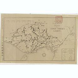
(Plan of Hiogo Treaty Limits)
Map of the new prefecture with Japanese and English descriptions. In lower right an key to "Position of Government Office, boundaries, road and railways. On January ...
Date: Meiji 10 = 1877

Paris fashion plate. (285)
From "Revue de la Mode - Gazette de la Famille". Underneath the print are the names of the shops where the clothing's, perfumes, porcelains, flowers, etc., depi...
- $30 / ≈ €25
Date: Paris, 1877

Paris fashion plate. (297)
From "Revue de la Mode - Gazette de la Famille". Underneath the print are the names of the shops where the clothing's, perfumes, porcelains, flowers, etc., depi...
- $40 / ≈ €34
Date: Paris, dated 1877

Paris fashion plate. (299)
From "Revue de la Mode - Gazette de la Famille". Underneath the print are the names of the shops where the clothing, perfumes, porcelains, flowers, etc., depict...
- $30 / ≈ €25
Date: Paris, dated 1877

Paris fashion plate. (311)
From "Revue de la Mode - Gazette de la Famille". Underneath the print are the names of the shops where the clothing's, perfumes, porcelains, flowers, etc., depi...
- $30 / ≈ €25
Date: Paris, dated 1877
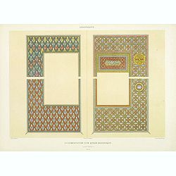
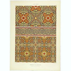
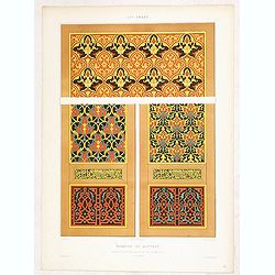
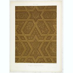
Arabesques. - Ornementation d'un Qoran Mauresque (XVIIIe siècle)
Lithographed by Daumont. From the author's "L'Art Arabe d'après les monuments du Kaire…". Emile Prisse d'Avennes, Orientalist and Muslim convert, obsessive i...
Date: Paris, 1877
Arabesques. - Pages jumelles d'un qorân mauresque. (XVIIIe siècle)
Lithographed by Daumont. From the author's "L'Art Arabe d'après les monuments du Kaire…". Emile Prisse d'Avennes, Orientalist and Muslim convert, obsessive i...
Date: Paris, 1877
![Art arabe. - [No tittle]](/uploads/cache/32750-250x250.jpg)
Art arabe. - [No tittle]
Lithographed by Daumont. From the author's "L'Art Arabe d'après les monuments du Kaire...". Emile Prisse d'Avennes, Orientalist and Muslim convert, obsessive i...
Date: Paris, 1877
Art arabe. - Séances de Hariry.
Lithographed by Daumont. From the author's "L'Art Arabe d'après les monuments du Kaire…". Emile Prisse d'Avennes, Orientalist and Muslim convert, obsessive i...
Date: Paris, 1877
Art arabe. - Mosquée d'El-Bordeyny.
Lithographed by Daumont. From the author's "L'Art Arabe d'après les monuments du Kaire...". Emile Prisse d'Avennes, Orientalist and Muslim convert, obsessive i...
Date: Paris, 1877
Art arabe. - Maison appelée beyt el-Tcheleby.
Lithographed by Daumont. From the author's "L'Art Arabe d'après les monuments du Kaire…". Emile Prisse d'Avennes, Orientalist and Muslim convert, obsessive i...
Date: Paris, 1877
Art arabe. - Mosquée de Qaytbay.
Lithographed by Daumont. From the author's "L'Art Arabe d'après les monuments du Kaire…". Emile Prisse d'Avennes, Orientalist and Muslim convert, obsessive i...
- $50 / ≈ €42
Date: Paris, 1877
Art arabe. - Mosquée cathédrale de qous assemblage & détails des pièces du mimbar. . .
Lithographed by Daumont. From the author's "L'Art Arabe d'après les monuments du Kaire…". Emile Prisse d'Avennes, Orientalist and Muslim convert, obsessive i...
Date: Paris, 1877
Art arabe. - Mosquée d'el-Bordeyny. . .
Lithographed by Daumont. From the author's "L'Art Arabe d'après les monuments du Kaire…". Emile Prisse d'Avennes, Orientalist and Muslim convert, obsessive i...
Date: Paris, 1877
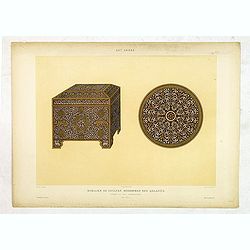
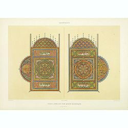
Art arabe. - Mobilier de soultan Mohammed Ben Qalaoûn coffret et plat damasquinés. . .
Lithographed by Daumont. From the author's "L'Art Arabe d'après les monuments du Kaire…". Emile Prisse d'Avennes, Orientalist and Muslim convert, obsessive i...
- $50 / ≈ €42
Date: Paris, 1877
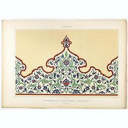
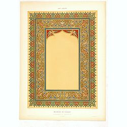
Arabesques. - Couronnement de la porte du Minbar de Gama Sysaryeh.
Lithographed by Daumont. From the author's "L'Art Arabe d'après les monuments du Kaire…". Emile Prisse d'Avennes, Orientalist and Muslim convert, obsessive i...
- $50 / ≈ €42
Date: Paris, 1877
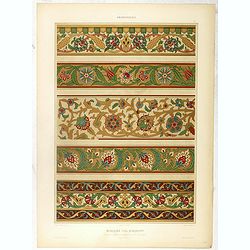
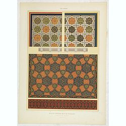
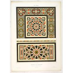
Arabesques. - Incrustations en stuc sur pierre.
Lithographed by Daumont. From the author's "L'Art Arabe d'après les monuments du Kaire…". Emile Prisse d'Avennes, Orientalist and Muslim convert, obsessive i...
- $30 / ≈ €25
Date: Paris, 1877
![[Schwarzes Meer] Nr 1](/uploads/cache/37946-250x250.jpg)
[Schwarzes Meer] Nr 1
Uncommon map of the Black Sea and Crimea. In lower part a scale. Prepared by Friedrich Handtke (1815-1879). Map set in a decorative border.
- $120 / ≈ €102
Date: Glogau, Leipzig, 1877

L'Art arabe d'après les monuments du Kaire depuis le VIIe siècle jusqu'à la fin du XVIIIe.
Prisse d’Avennes was one of the foremost scholars of Arabic art and architecture of the 19th century; this work represents the summation of his studies. From the aspect...
Date: Paris, Morel, 1877