Browse Listings
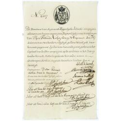
Very rare share in the Ostend Company. (4527)
Upper left hand corner share number 4527 in manuscript. In top emblem of the Ostend Company in copper engraving. Text: De Directeurs van de generale Keijserlijche- Indisc...
Date: Antwerp / Ostend 1723
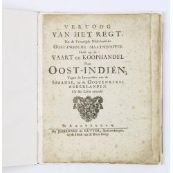
Vertoog van het regt, Dat de Vereenigde Nederlandsche Oost-Indische maatschappye Heeft op de Vaart en Koophandel naar Oost-Indiën, Tegen de inwooners van de Spaanse, nu de Oostenrykse Nederlanden.
Dutch translation of the Latin edition, published in 1723. Westerveen was the secretary of the Dutch East India Company and writes on the right of the VOC to trade as wel...
- $1200 / ≈ €1020
Date: Amsterdam, 1724
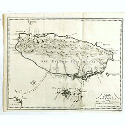
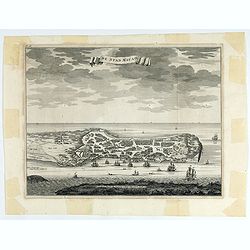
Kaart van het Eyland Formosa en de Eylanden van Piscadores.
The earliest printed map of Taiwan or Formosa. Oriented to the east, with north at the left, covering the entire island and the nearby Pescadores, now known as the Penghu...
Date: Amsterdam, 1724
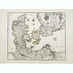
Le Royaume de Danemarc et les Etats.
Map centered on Sweden and North Germany.
Date: Paris, 1724
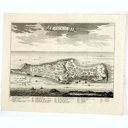
De Stad Macao.
A fine view of the city of Macao from Lappa Island showing the defenses, the forts, churches and convents: including Fort de Baare, Bon Parto, Fort St Paulo (Monte Fort)....
Date: Amsterdam, 1724
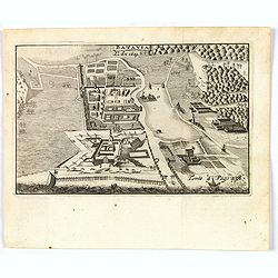
Platte Grond vande Stadt Macao.
A fine view of the city of Macao from Lappa Island showing in schematic blocks the structure of the town. With European vessels and junks in the surrounding water. With n...
Date: Amsterdam, 1724
![[The Philippines]](/uploads/cache/49201-250x250.jpg)
[The Philippines]
Fine chart depicting the Islands of the Philippines. Little interior detail is given but the coastlines, settlements and principal coastal features are identified. An att...
Date: Amsterdam, 1724
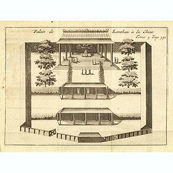
Palais de Lamthau à la Chine.
View of a Mandarin's Palace at Lantau Island, showing the palace wall, 3 gates and guards in the inner palace where the Mandarin meets with the officers.. Tome 3 Page 392...
- $75 / ≈ €64
Date: Amsterdam, J.F. Bernard, 1725
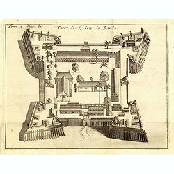
Fort de l'Isle de Banda.
Decorative print of the Dutch fortress on the island Banda.From the French reissue of the account of early Dutch voyages first published in 1608 by Commelin. The French t...
- $90 / ≈ €76
Date: Amsterdam, F. Bernard, 1725
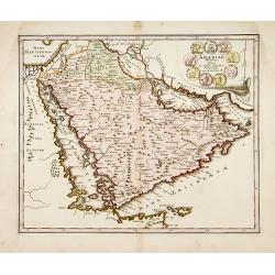
Arabiae Veteris.
A very striking map of the ancient Arabian Peninsula, embellished with an colored pictorial title cartouche.Read more about Mapping of Arabia and of Arabia and the Persi...
- $550 / ≈ €467
Date: Nuremberg, 1725
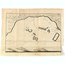
(Gunanappi / Wayer / Nera / Pulorin / Puloway .)
Uncommon map of islands in the Banda Sea. Several islands and villages are named, Wayer, Nera, Pulorin, Puloway, Lontoor, Ortattan and Combeer.From the French reissue of ...
- $75 / ≈ €64
Date: Amsterdam, F. Bernard, 1725
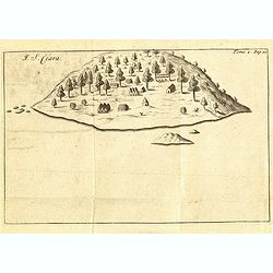
I. S. Clara.
Island "S. Clara" in Brazil just a few degrees north of the Tropic of Capricorn.From volume two of the French reissue of the account of early Dutch voyages. The...
- $100 / ≈ €85
Date: Amsterdam, F. Bernard, 1725
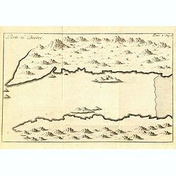
Porto il Desire.
Simplified bird's-eye view of Port Desire or Puerto Deseado in present-day Argentina.From volume two of the French reissue of the account of early Dutch voyages. The Fren...
- $150 / ≈ €127
Date: Amsterdam, F. Bernard, 1725
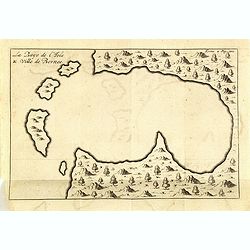
La Baye de l'Isle & ville de Borneo.
Uncommon map of a Bay on the island of Borneo. From the French reissue of the account of early Dutch voyages first published in 1608 by Commelin. The French translation w...
- $75 / ≈ €64
Date: Amsterdam, F. Bernard, 1725
La ville et le fort de Gamma-Lamma dans l'isle de Ternate lequel fort apartient aux Espagnols.
A view of the town and fortress on the island of Ternate. The city was in the southern part of the island, in the place now called Kastela. From the French reissue of the...
- $100 / ≈ €85
Date: Amsterdam, J.F. Bernard, 1725
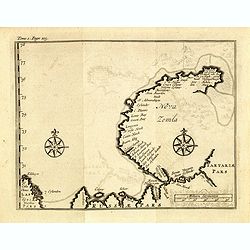
(Map of Nova Zembla with inset of Baye de Loms.)
Map of Nova Zembla with inset of Baye de Loms (5x7mm.).From the French reissue of the account of early Dutch voyages first published in 1608 by Commelin. The French trans...
- $100 / ≈ €85
Date: Amsterdam, F. Bernard, 1725
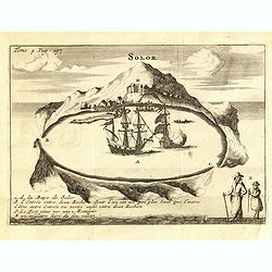
Solor / A la Baye de Solor.
Decorative map of the Bay of Solor. With a lettered key (A - E). Solor is a volcanic island located off the eastern tip of Flores island in the Lesser Sunda Islands of In...
- $75 / ≈ €64
Date: Amsterdam, F. Bernard, 1725
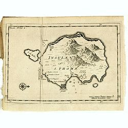
Insulae S. Thomae.
Uncommon map of the Island of St. Thomas located in the Atlantic Ocean near West Africa. From the French reissue of the account of early Dutch voyages first published in ...
- $75 / ≈ €64
Date: Amsterdam, F. Bernard, 1725
Ducatus Silesiae Iauranus. Aut : Frid : Kühnovio. . .
Rare Pieter Schenk edition of Friedrich Kubn's (Kühnovio) map of Jawor in southwest Poland based on Johann Gottfried Bartsch, map first published in Świdnica (then Schw...
Date: Amsterdam, 1700-1725
Isle du Prince.
Simplified bird's-eye view of "Isle du Prince" in present-day Argentina.From volume two of the French reissue of the account of early Dutch voyages. The French ...
- $75 / ≈ €64
Date: Amsterdam, F. Bernard, 1725
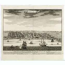
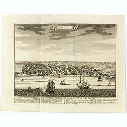
Batavia, L'an 1629.
Scarce town-view of Batavia (Jakarta) in 1629.From the French reissue of the account of early Dutch voyages first published in 1608 by Commelin. The French translation wa...
- $150 / ≈ €127
Date: Amsterdam, 1725
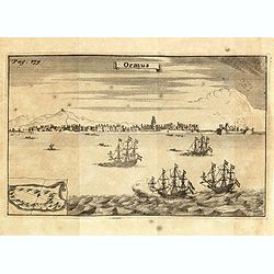
Ormus. (Hormuz)
Panoramic view of the town of Hormuz, with little inset map of the island. From the French reissue of the account of early Dutch voyages first published in 1608 by Commel...
- $200 / ≈ €170
Date: Amsterdam, F. Bernard, 1725

Idolle des Chinois.
Print of a Chinese divinity. Tome 3 Page 377 in upper left corner. From the French reissue of the account of early Dutch voyages first published in 1608 by Commelin. The ...
- $75 / ≈ €64
Date: Amsterdam, J.F. Bernard, 1725
![[12 volumes] Recueil des voyages qui ont servi à l'établissement et aux progrez de la Compagnie des Indes Orientales, forméedans les Provinces-Unies des Païs-Bas...](/uploads/cache/43700-250x250.jpg)
[12 volumes] Recueil des voyages qui ont servi à l'établissement et aux progrez de la Compagnie des Indes Orientales, forméedans les Provinces-Unies des Païs-Bas...
An important, richly illustrated compendium of the first Dutch voyages to East India, of great interest for the history and establishment of the Dutch global trade, parti...
Date: Rouen, Pierre Le Boucher, 1725
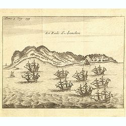
La rade d'Annobon.
Fine print of the arrival of the Dutch fleet by Cornelis Matelief de Jonge at Annobon, September 7th 1605. Cornelis Matelief de Jonge made a trip for the V.O.C. to the Ea...
- $100 / ≈ €85
Date: Amsterdam, J.F. Bernard, 1725
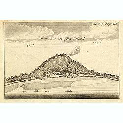
Ternate, par son aspect oriental.
This map is a view of Ternate with the summit of Gamalama from Dodoku Ali. From the French reissue of the account of early Dutch voyages first published in 1608 by Commel...
- $75 / ≈ €64
Date: Amsterdam, J.F. Bernard, 1725
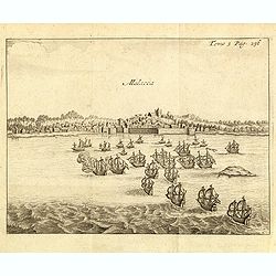
Malacca.
Fine print showing Dutch vessels offshore the city of Malacca and it is located 2 degrees north of the equator by the shore of the Straits of Malacca between Singapore to...
- $175 / ≈ €149
Date: Amsterdam, J.F. Bernard, 1725
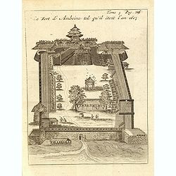
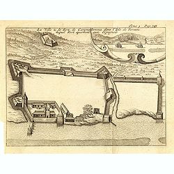
Le fort d'Amboine tel qu'il était en l'an 1607.
Fine plan of the Dutch fortress on Ambon Island which is part of the Maluku Islands of Indonesia. The island has an area of 775 km2 (299 sq mi).From the French reissue of...
- $75 / ≈ €64
Date: Amsterdam, J.F. Bernard, 1725
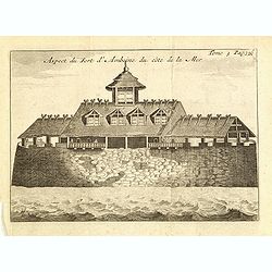
Le fort d'Amboine tel qu'il était en l'an 1607.
Fine depiction of the Dutch fortress on Ambon Island which is part of the Maluku Islands of Indonesia. The island has an area of 775 km2 (299 sq mi).From the French reiss...
- $80 / ≈ €68
Date: Amsterdam, J.F. Bernard, 1725
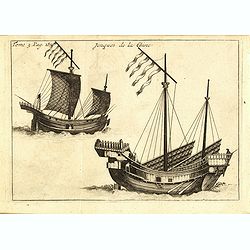
Jonques de la Chine.
A depiction of two Chinese junks. Tome 3 Page 377. From the French reissue of the account of early Dutch voyages first published in 1608 by Commelin. The French translati...
- $75 / ≈ €64
Date: Amsterdam, J.F. Bernard, 1725
(Bird's eye view of the Bay of Bantam)
Early view of the Bay of Bantam with the islands of Pulo dua and Batto.Bantam was always a product of the ferocious commercial rivalry between the Dutch and English and P...
- $75 / ≈ €64
Date: Amsterdam, F. Bernard, 1725
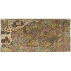
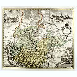
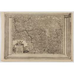
Les Provinces des Pais Bas Autrichiens contenants en XXIV Feuilles les comtées d'Artois, de Flandres, de Hainaut, de Namur et des Duchées de Luxembourg…
Rare wall map of the Catholic of Austrian Low Countries, roughly the southern part of present-day The Netherlands, Belgium and Luxembourg. Map has some large cartouches, ...
Date: Augsburg, 1725
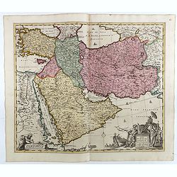
Nova Persiae Armeniae Natoliae et Arabiae.
This fine map shows the area East from Cyprus to Iran, including The Saudi Peninsula, Red Sea, Nile River, Cyprus, Asia Minor, the Gulf of Aden, Indian Ocean, Armenia, th...
- $750 / ≈ €637
Date: Amsterdam, 1725
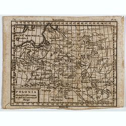
Polonia secondo le obzervazioni dell'accademiadi Parigi.
Uncommon Italian map of present day Poland and Lithuania prepared by Claude Buffier was a Jesuit theologian and geographer working in Paris, who wrote the Geographie Univ...
- $150 / ≈ €127
Date: Naples, Rome, ca. 1725

Osmann der altiste sohn Achmats der Ersten.
Portrait of Osmann (1605-1622) by Franz Christoph Khevenhiller, from Annales Ferdinandei, oder warhaffte Beschreibung Käysers Ferdinandi des anderen, mildesten Gedächtn...
Date: Leipzig, Weidmann 1721-1726
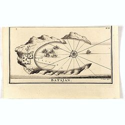
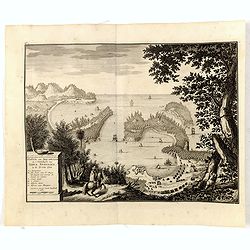
Batsjan. (Bacan)
Decorative panoramic view of Bay with the Dutch fortress Barneveld at the island of Bacan in today's Indonesia. Dutch (V.O.C.) sailing ships are illustrated.François Val...
- $45 / ≈ €38
Date: Amsterdam, 1726
Cilicia Asiae Minoris pars orientalis. . .
Uncommon map of Cilicia, an ancient region and former kingdom of SE Asia Minor, between the Taurus Mountains and the Mediterranean: corresponds to the region around prese...
Date: Paris/ Bordeaux, 1726
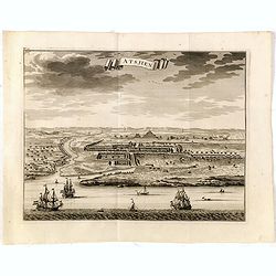
Samboepo in platte Grond.
Decorative panoramic view of the town of Samboupo on the island of Celebes (Sulawesi) in today's Indonesia. Dutch (V.O.C.) sailing ships and various local craft fill the ...
- $150 / ≈ €127
Date: Amsterdam, 1726

Die Insel Formosa neu abgemessen auf Befehl Kaysers Kamhi.
One of the earliest obtainable printed maps of Taiwan or Formosa Island. It was issued around 1726 to illustrate Joseph Stöcklein's [Stoecklein] compellation of Jesuit m...
Date: Augsburg, 1726

Nieuwe kaart van 't Koninckryk Bengale. . .
Rare map Bangladesh with the Ganges delta, including Calcutta. Giving great detail with trade routes, European trade settlements, etc. Prepared by Joh. Van Leenen who was...
Date: Amsterdam, 1726

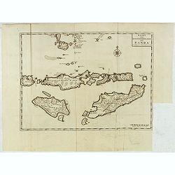
Nieuwe Caart der Eylanden van Banda.
Decorative map of the Banda Islands.François Valentijn (1666-1727), a missionary, worked at Amboina from 1684 to 1694 and 1705 to 1713 and travelled extensively in the V...
Date: Amsterdam, 1726
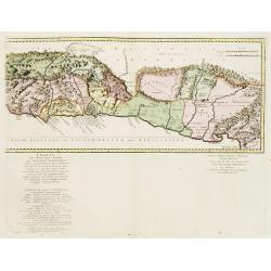
Kaart van de Zuyd-Wester Eylanden van Banda.
Map of the Banda islands.François Valentijn (1666-1727), a missionary, worked at Amboina from 1684 to 1694 and 1705 to 1713 and travelled extensively in the VOC's lands....
- $400 / ≈ €340
Date: Amsterdam, 1726
Samboepo in platte Grond.
Decorative panoramic view of the town of Samboupo on the island of Celebes (Sulawesi) in today's Indonesia. Dutch (V.O.C.) sailing ships and various local craft fill the ...
- $150 / ≈ €127
Date: Amsterdam, 1726
De Landvoogdy der Moluccos met de Aangrenzende Eylanden . . .
Two charts on one sheet depicting the Moluccas islands. Little interior detail is given but the coastlines, settlements and principal coastal features are identified. To ...
Date: Amsterdam, 1726
De Kust van Nova Guinea tot aan deze bogt . . .
De kust van Nova Guinea tot aan deze bogt.De Kust van Nova Guinea ofte Salomon Sweers hoek. Het Landt van Nova Guinea in de Groote Bocht daar wy vergeefs hoopten een doo...
Date: Amsterdam, 1726
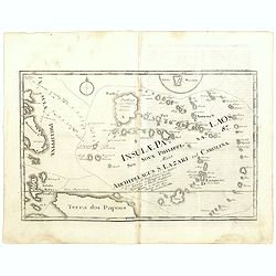
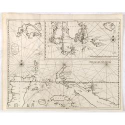
Insulae Palaos seu Novae Philippinae 87 Alias Archipelagus S. Lazari ven Carolinae . . .
Map of Philippine archipelago. Stöcklein's work is a compound of letters of the Jesuit missionaries from all over the world and here particularly the ones stationed at t...
Date: Augsburg, 1726

Nieuwe Kaart van het Eyland Sumatra..
Fine chart depicting the Island of Sumatra and the southern coasts of Malaysia from Quedo to Johore. North is orientated to the left of the page. Singapore is probably id...
Date: Amsterdam, 1726
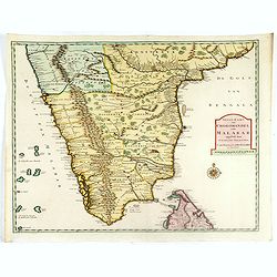
Nieuwe Kaart van Choromandel ende Malabar. . .
Fine map depicting the southern part of India and the northern tip of Ceylon. Much detail is given along the coastlines, settlements and principal coastal features are id...
- $550 / ≈ €467
Date: Amsterdam, 1726
Haven van Aquapulco in ' Coninkryk van Nova Spagnien in de Zuyd Zee.
A finely engraved plan of the harbor, fort and village of Acapulco drawn from a hilltop vantage point looking out to sea. Several galleons are pictured approaching or anc...
- $500 / ≈ €425
Date: Amsterdam, 1726
Astjien.
Nice bird's eye-view of the Town of Atjien on the northernmost point of Sumatra by François Valentijn (1666-1727), a missionary, who worked at Amboina from 1684 to 1694 ...
- $225 / ≈ €191
Date: Amsterdam, 1726
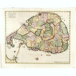
Nieuwe kaart van het Eyland Ceylon. . .
Fine map depicting the Island of Ceylon/Sri Lanka, oriented with north to the left.. Good interior detail is given with settlements, roads, etc. An attractive early map, ...
- $850 / ≈ €722
Date: Amsterdam, 1726
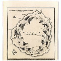
Makjan Geheel Bergagtig.
The island of Makian in Indonesia (formerly the Dutch East Indies) is represented on this map as a mountainous Möbius strip around a giant donut hole. François Valentij...
- $150 / ≈ €127
Date: Amsterdam, 1726
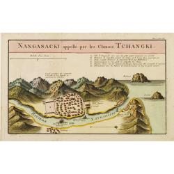
Nangasaki appellé par les Chinois Tchangki.
Attractive bird's-eye view of Nagasaki, with reference key to principal points of interest, including the Dutch V.O.C. Company House. The Dutch/Chinese enclave is central...
- $250 / ≈ €212
Date: Paris, 1727

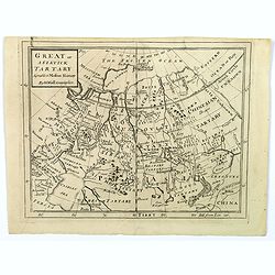
Great or Asiatick Tartary, Agreable to Modern History.
Map of Tartary to Peking. The eastern coastline of Asia is almost flat, with no attempt to mark Kamchatka.
- $275 / ≈ €234
Date: London, 1727
Great or Asiatick Tartary, Agreeable to Modern History.
A map from the Frozen Ocean in the north to Usbec Tartary in the south, from Moscow in the west to China Tartary and Peking in the east. Rivers and mountains feature prom...
- $125 / ≈ €106
Date: London, ca. 1727
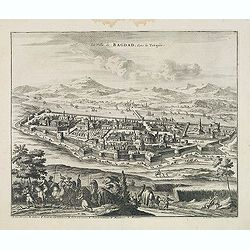
La Ville de Bagdad, dans la Turquie.
Decorative view of the town of Bagdad. This well executed engraving was published in 1729 and 1727 by Pieter van der AA, in Leiden in "Voyages tres-curieux et tres-r...
Date: Leiden, 1719-1727
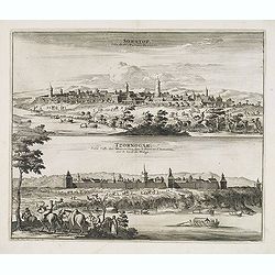
Soratof, ville de Tartarie Moscovite. / Tzornogar, Petite Ville des Moscovites, dans le Royaume d'Astracan, sur le bord du Volga.
Decorative engraving of two panoramic views in top Saratov with in the foreground the Volga River and in bottom a view of Chernyy Yar on the Volga River. This well execut...
Date: Leiden, 1719-1727
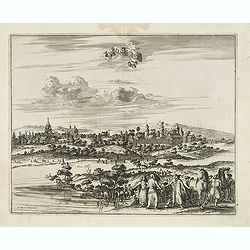
Cassimogorod ville de la Tartarie Moscovite.
Decorative view of the town of Kasimov on the Oka River, east from Moscow and south from Murom near the northern shore of the Caspian Sea. The city is seen from across th...
Date: Leiden, 1719-1727
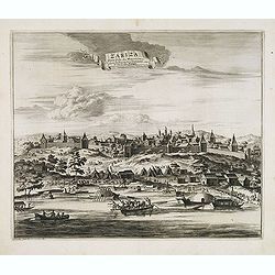
Zariza, petite ville des Moscovites, dans le royaume d'astracan, sur le bord du Wolga.
Decorative view of the town of Volgograd (Zarizyn) on the Volga River. This well executed engraving was published in 1729 and 1727 by Pieter van der AA, in Leiden in &quo...
Date: Leiden, 1719-1727
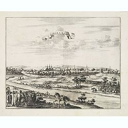
Moruma ville de la Tartarie Moscovite.
Decorative view of the town of Moruma, Russian city near the northern shore of the Caspian sea as seen from across the river Oka. This well executed engraving was publish...
Date: Leiden, 1719-1727
![[Title page] Atlas Historique ou nouvelle introduction à l'Histoire, à la Chronologie & à la Géographie Ancienne & Moderne . . . (Tome I)](/uploads/cache/39002-250x250.jpg)
[Title page] Atlas Historique ou nouvelle introduction à l'Histoire, à la Chronologie & à la Géographie Ancienne & Moderne . . . (Tome I)
Title page from Chatelain's monumental 7 volume Atlas Historique, Tome I. Henri Abraham Chatelain (1684 – 1743) was a Huguenot pastor of Parisian origins. He lived cons...
- $30 / ≈ €25
Date: Amsterdam, 1728
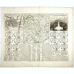
Carte Historique et Geographique pour Introduire a l' Intelligence de l'Histoire de Savoye . . .
Folio sheet with an attractive map of the border region of France, Switzerland and Italy. An inset map of the fortification of Torino and the Palace of Venerie. Cartouche...
Date: Amsterdam, 1728
L'Archeveché de Mayence, suivant les nouvelles observations..
With decorative title cartouche lower left corner. Including river Rhine. This example is unusual in having the additional separately engraved decorative framework border...
- $100 / ≈ €85
Date: Amsterdam, 1728
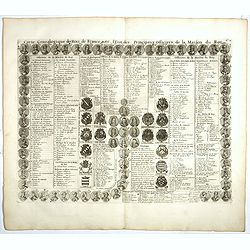
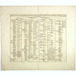
Carte genealogique des Rois de France avec l'Etat des Principaux Officiers de la Maison du Roy.
A genealogical tree of the French Kings with descriptive French text, from Chatelain's monumental 7 volume "Atlas Historique". Henri Abraham Chatelain (1684 –...
- $35 / ≈ €30
Date: Amsterdam, 1728
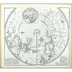
This Draught of the North Pole is to show all the Countries near and adjacent to it . . .
The polar map shows the latest discoveries and routes of numerous explorers during their attempts to find a Northwest and Northeast Passage, including James, Hudson, and ...
- $300 / ≈ €255
Date: London, ca. 1728
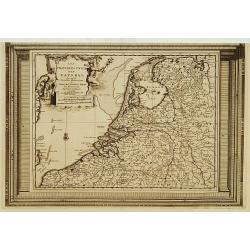
Les Provinces Unies des Pays Bas, suivant les nouvelles observations. . .
With decorative title cartouche upper left corner.This example is unusual in having the additional separately engraved decorative framework border around the map, the res...
Date: Amsterdam, 1728
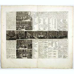
Carte du Gouvernement Civil de France.
This impressive engraving is a wonderful example of Chatelain’s elegant plates. It provides a detailed description of the infrastructure of the French government. Ornam...
- $75 / ≈ €64
Date: Amsterdam, 1728
Landgraviat de Hesse, suivant les nouvelles observations..
With decorative title cartouche lower right corner.This example is unusual in having the additional separately engraved decorative framework border around the map, the re...
- $90 / ≈ €76
Date: Amsterdam 1728

Carte du Gouvernement de Provence, suivant les nouvelles observations...
Fine copper engraved and decorative map of the Provence region in the south of France. It includes the cities of Nimes, Viviers, Avignon, Aix and Nice. The pictorial cart...
Date: Amsterdam 1728
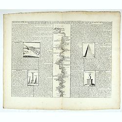
Description du Nil, de ses sources, de son cours depuis les cataractes jusques le Caire . . .
Detailed map of the course of the Nile, from the cataracts of the Nile at the south (top of the image) to Caïro and Giza. At the right, one of the Pyramids is shown (140...
Date: Amsterdam, 1728
A Chart of the Sound -- A Map of the rivers Elbe and Weser -- The River Dvina and the harbour of Archangel.
Scarce sea chart by John Harris (1667?-1719) and James Knapton (d. 1738). Chart 20 from "Atlas maritimus & commercialis", shows Lapland and part of the Russ...
- $400 / ≈ €340
Date: London, J. Knapton, 1728
Division generale de l'Amerique dans ses principales parties pour l'intelligence de la carte de ce païs.
This folio sheet gives a breakdown of America into the northern and southern regions. These are further subdivided into the various countries and provinces.Henri Abraham ...
Date: Amsterdam, 1728
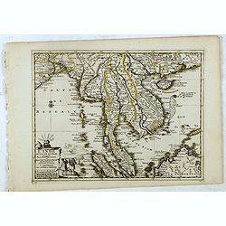
L'Inde de la le Gange, suivant les nouvelles observations...
Decorative map of Malaysia, Thailand, Indo-China, and the Northern parts of the islands of Sumatra and Borneo. Singapore marked as Sincapour.Originally published by Piete...
Date: Amsterdam, 1728
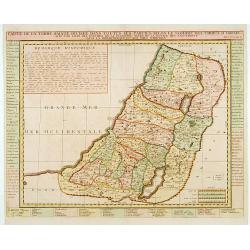
Carte de la Terre Sainte Divisée dans toutes ses. . .
A finely engraved map depicting the division of the Holy Land into twelve tribes.
- $400 / ≈ €340
Date: Amsterdam, 1728
![[No title] Mongol.](/uploads/cache/39729-250x250.jpg)
[No title] Mongol.
Interesting sheet with four detailed engravings illustrating Mongol's life scenes. In upper right margin: 'Tom. V. No 43. Pag: 116.Henri Abraham Chatelain (1684 – 1743)...
Date: Amsterdam, 1728
![[No title] Hindou](/uploads/cache/39730-250x250.jpg)
[No title] Hindou
Interesting sheet with four detailed engravings illustrating Hindou's life scenes. In upper right margin: 'Tom. V. No 42. Pag: 116.Henri Abraham Chatelain (1684 – 1743)...
Date: Amsterdam, 1728

L'Inde de la le Gange, suivant les nouvelles observations...
Uncommon edition of this map of Malaysia, Thailand, Indo China and the Northern parts of the islands of Sumatra and Borneo. Singapore marked as Sincapour. With decorative...
Date: Amsterdam, 1728
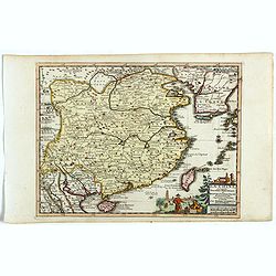
La Chine suivant les nouvelles observations...
Uncommon edition of this map of China. From Le Nouveau Theatre du Monde, ou la Geographie Royale.Curious shape of South Korea.
- $1100 / ≈ €935
Date: Amsterdam, 1728

L'Asie suivant les nouvelles observations...
Uncommon edition of this map of Asia. From Le Nouveau Theatre du Monde, ou la Geographie Royale.The map is of interest for the use of Mer Orientale, the sea between Kor...
Date: Amsterdam, 1728
Carte historique et géographique pour servir à l'Histoire Sainte et à la Vocation de Saint Paul, avec quelques remarques curieuses pour servir à l'Histoire des Antiquités judaïques.
Interesting sheet with a map of the travels of Saint Paul, including eastern part of Europe, Asian continent and part of north Africa, with descriptive French text, from ...
Date: Amsterdam, 1728