Browse Listings
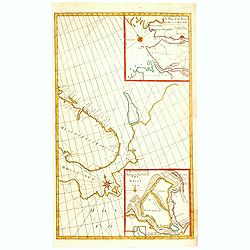
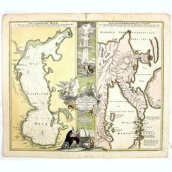
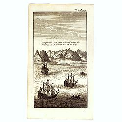
A Chart of the Sound -- A Map of the rivers Elbe and Weser -- The River Dvina and the harbour of Archangel.
Scarce sea chart by John Harris (1667?-1719) and James Knapton (d. 1738). Chart 20 from "Atlas maritimus & commercialis", shows Lapland and part of the Russ...
- $400 / ≈ €340
Date: London, J. Knapton, 1728
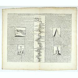
Description du Nil, de ses sources, de son cours depuis les cataractes jusques le Caire . . .
Detailed map of the course of the Nile, from the cataracts of the Nile at the south (top of the image) to Caïro and Giza. At the right, one of the Pyramids is shown (140...
Date: Amsterdam, 1728

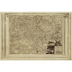
Carte du Gouvernement de Provence, suivant les nouvelles observations...
Fine copper engraved and decorative map of the Provence region in the south of France. It includes the cities of Nimes, Viviers, Avignon, Aix and Nice. The pictorial cart...
Date: Amsterdam 1728
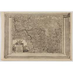
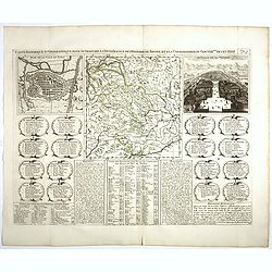
Landgraviat de Hesse, suivant les nouvelles observations..
With decorative title cartouche lower right corner.This example is unusual in having the additional separately engraved decorative framework border around the map, the re...
- $90 / ≈ €76
Date: Amsterdam 1728
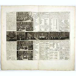
Carte du Gouvernement Civil de France.
This impressive engraving is a wonderful example of Chatelain’s elegant plates. It provides a detailed description of the infrastructure of the French government. Ornam...
- $75 / ≈ €64
Date: Amsterdam, 1728
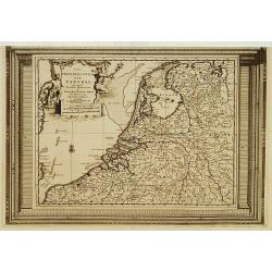
Les Provinces Unies des Pays Bas, suivant les nouvelles observations. . .
With decorative title cartouche upper left corner.This example is unusual in having the additional separately engraved decorative framework border around the map, the res...
Date: Amsterdam, 1728
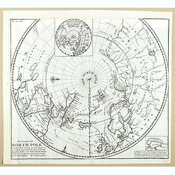
This Draught of the North Pole is to show all the Countries near and adjacent to it . . .
The polar map shows the latest discoveries and routes of numerous explorers during their attempts to find a Northwest and Northeast Passage, including James, Hudson, and ...
- $300 / ≈ €255
Date: London, ca. 1728
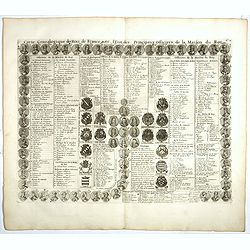
Carte genealogique des Rois de France avec l'Etat des Principaux Officiers de la Maison du Roy.
A genealogical tree of the French Kings with descriptive French text, from Chatelain's monumental 7 volume "Atlas Historique". Henri Abraham Chatelain (1684 –...
- $35 / ≈ €30
Date: Amsterdam, 1728
L'Archeveché de Mayence, suivant les nouvelles observations..
With decorative title cartouche lower left corner. Including river Rhine. This example is unusual in having the additional separately engraved decorative framework border...
- $100 / ≈ €85
Date: Amsterdam, 1728
Carte Historique et Geographique pour Introduire a l' Intelligence de l'Histoire de Savoye . . .
Folio sheet with an attractive map of the border region of France, Switzerland and Italy. An inset map of the fortification of Torino and the Palace of Venerie. Cartouche...
Date: Amsterdam, 1728
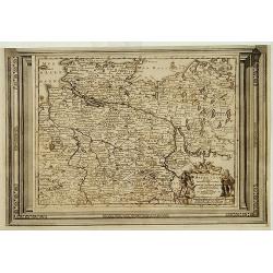
Cercle de la Basse Saxe, suivant les nouvelles observations..
Uncommon edition of this map of a province of Germany, including Hamburg, Bremen, etc. With decorative title cartouche lower right corner.This example is unusual in havin...
- $90 / ≈ €76
Date: Amsterdam 1728
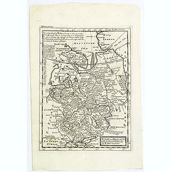
Le Duché de Lunebourg, suivant les nouvelles observations?
Uncommon edition of this map of a province of Germany. With decorative title cartouche upper right corner.This example is unusual in having the additional separately engr...
- $80 / ≈ €68
Date: Amsterdam, 1728
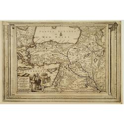
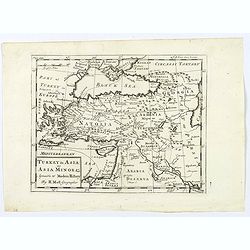
Turquie en Asie, suivant les nouvelles observations..
Uncommon edition of this map of Turkey, Holy Land, Armenia, including Cyprus. With decorative title cartouche lower left corner.This example is unusual in having the addi...
Date: Leiden, 1728
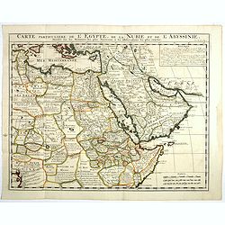
Carte Particuliere De L'Egypte, De La Nubie et de L'Abyssinie, Dressee sur les Memoires les plus Nouveaux & les Observation les plus exactes.
Including the Arabian Peninsular, Egypt, north eastern part of Africa, Cyprus and part of the Mediterranean.Based on the work of Guillaume Delisle. It is a very detailed ...
- $400 / ≈ €340
Date: Amsterdam, 1728
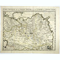
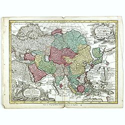
Carte Nouvelle de la Grande Tartarie ou de l'Empire du du Grand Cham. . .
Very detailed map of Northern China, Korea, Russia in the north the Murmansk Sea. Including the western coast of Nova Zembla. Zacharie Chatelain (d.1723) was the father o...
- $250 / ≈ €212
Date: Amsterdam, 1728
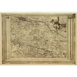
La Souabe meridionale, suivant les nouvelles observations..
Uncommon edition of this map of Southern Germany. With decorative title cartouche lower right corner.This example is unusual in having the additional separately engraved ...
- $90 / ≈ €76
Date: Amsterdam 1728
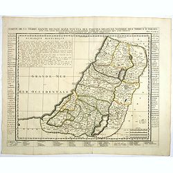
Carte de la Terre Sainte Divisée dans toutes ses parties. . .
A finely engraved map depicting the division of the Holy Land into twelve tribes.Zacharie Chatelain (d.1723) was the father of Henri Abraham (1684-1743) and Zacharie Juni...
- $350 / ≈ €297
Date: Amsterdam, 1728
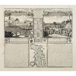
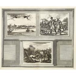
Succession Des Empereurs Du Japon Avec Une Description Du Meurtre De L'Empereur Cubo Et La Reception Des Ambassadeurs Hollandais En Ce Pays . . .
Composite sheet, with a small map of Japan and two detailed views: one depicting the murder of the Emperor Cubo, the other, the reception of the Dutch ambassadors, each w...
- $300 / ≈ €255
Date: Amsterdam, 1728

Carte qui contient..Iles & Terres..L'Amerique..Jamaique..
Eight maps on one sheet. From Chatelain's Atlas Historique et Méthodique . Including maps of Bermuda, Jamaica, New England with Long Island, Carolina, Chesapeake and Del...
Date: Amsterdam 1728
![[Printed on silk] Nieuw Wassende Graaden Paskaart Vertoonende alle de bekende Zeekusten en Landen op den geheelen Aard Boodem of Werelt door Gerard van Keulen. . .](/uploads/cache/31640-250x250.jpg)
[Printed on silk] Nieuw Wassende Graaden Paskaart Vertoonende alle de bekende Zeekusten en Landen op den geheelen Aard Boodem of Werelt door Gerard van Keulen. . .
A very scarce and beautiful chart on Mercator's projection printed on silk. With the name of Gerard van Keulen and the privilege. The map shows great interior detail, inc...
Date: Amsterdam, 1728
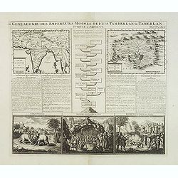
Genealogie des anciens empereurs mogols,. . .
Text sheet with two inset maps of "Carte de l'empire du grand Mogol (122x158mm.) and inset map of Kahsmire "carte nouvelle du royaume de Kachemire" (120x15...
- $150 / ≈ €127
Date: Amsterdam, 1728

Carte nouvelle des Terres de Cucan..
Prepared by H.Reland (1676-1718) a professor active in Utrecht and specialized in Asian languages, geography and religions. His first map was a map of Japan copied after ...
Date: The Hague, 1728
L'Italie dans son Premier Etablissement sous la Republique Romaine. . .
Map of Italy when first established under the Roman Republic after the division by Ayuguste Caesar, its various Papal governments: ancient Rome and its surround dings, a ...
Date: Amsterdam, 1728

Habillement de l'Empereur de la Chine & des Dames de son Palais..
This impressive engraving is a wonderful example of Chatelain’s elegant plates.Divided in 3 panels, showing examples of costumes of Chinese ladies and those of the king...
Date: Amsterdam, ca. 1728
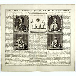
Habillemens Des Arabes & Des Juifs qui sont au Caire avec une partie de leurs divertissements & quelques restes de L'Ancien Idolatrie des peuples D'Egipte.
Decorative set of images the costumes of the Arab and Jewish inhabitants of Cairo, with French text, from Chatelain's monumental 7 volume Atlas Historique. Henri Abraham ...
Date: Amsterdam, 1728
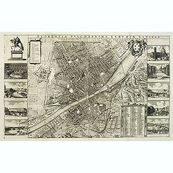
Florentia Pulcherrima et Ruriae Civitas.
Detailed bird's-eye view of the town of Florence in Tuscany region, first published in Frederick de Wit's rare town book. With two keys 1-17 and 1-228 to important spots ...
Date: Amsterdam, Leiden, 1697 / 1729
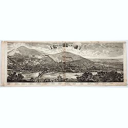
Heidelberg.
A spectacular panoramic view of Heidelberg, with legends numbered from 1-72 in German. With the title in a banderol.After a design by Friedrich Bernhard Werner (1690-1776...
- $1500 / ≈ €1275
Date: Augsburg, 1729

Histoire Naturelle, Civile, Et Ecclésiastique..'
First French edition, published by P. Gosse, J. Neaulme and B. Lakeman. The basic work on Japan from the second half of the 17th century when it was still forbidden for f...
Date: Amsterdam, 1729
Novum Amsterodamum. . .
Three engravings on one page are set in a decorative, separately engraved border. - In the upper left is a good example of one of the earliest available views of New York...
Date: Leiden, 1729
Historic Map - Naaukeurige Kaart Van Tartaryen, Soo als dat door W De Rubruquis doorreyst.
This attractive map published by Pieter van der Aa, shows Tartary abd the ancient Silk Road region. The map shows the track of William of Rubruck (Willem van Rubroeck or ...
Date: Amsterdam, 1713-1729
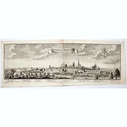
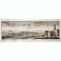
Neis in Schlesien. (Nysa)
A spectacular panoramic view of Nysa in southwestern Poland, with legends numbered from 1-23 in German. With the title in a banderol.After a design by Friedrich Bernhard ...
- $2500 / ≈ €2125
Date: Augsburg, 1729
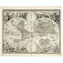
Orbis terrarum typus de integro in plurimis emendatus auctus et icunculis illustratus.
Outstanding and rare example of a bible world map based on the Visscher bible map from 1657 (Shirley 401/414). This map is larger in size and has an extra engraved frame ...
Date: Minden, 1729
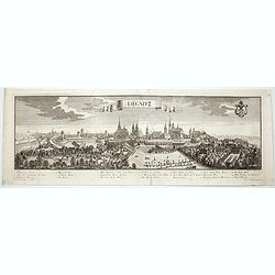
Lirgnitz. (Legnica)
A spectacular panoramic view of Legnica in southwestern Poland, in the central part of Lower Silesia, with legends numbered from 1-20 in German. With the title in a bande...
- $2500 / ≈ €2125
Date: Augsburg, 1729
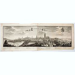
Schweidnitz. (Swidnica)
A spectacular panoramic view of Swidnica is a city in south-western Poland, with legends numbered from 1-19 in German. With the title in a banderol.After a design by Frie...
- $2500 / ≈ €2125
Date: Augsburg, 1729
Bamberg in Francken.
A spectacular panoramic view of Bamberg, with legends numbered from 1-24 in German. With the title in a banderol.After a design by Friedrich Bernhard Werner (1690-1776) w...
- $1500 / ≈ €1275
Date: Augsburg, 1729
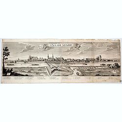
Ingolstadt.
A spectacular panoramic view of Ingolstadt in Bavaria, with legends numbered from A-P and 1-6 in German. With the title in a banderol.After a design by Friedrich Bernhard...
- $1500 / ≈ €1275
Date: Augsburg, 1729
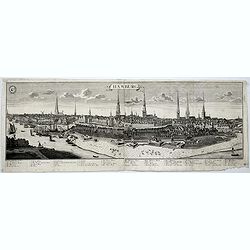
Hamburg.
A spectacular panoramic view of Hamburg, with legends numbered 1-19 and A-Z in German. With the title in a banderol.After a design by Friedrich Bernhard Werner (1690-1776...
- $2000 / ≈ €1700
Date: Augsburg, 1729
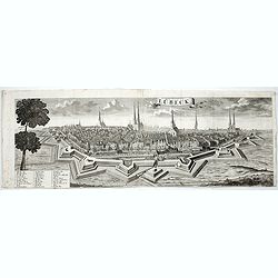
Lübeck.
A spectacular panoramic view of Lübeck, with legends numbered 1-28 in German. With the title in a banderol.After a design by Friedrich Bernhard Werner (1690-1776) who wa...
- $1500 / ≈ €1275
Date: Augsburg, 1729
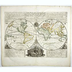
Mappe-Monde pour connoitre les progres & les conquestes..
Unusual double hemisphere map with California as an Island. Dutch text describes the expeditions and colonial possessions of the Dutch East India Company. The map origina...
Date: Amsterdam, 1729
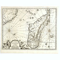
Ile de S. Laurens, ou Madagascar, située dans L'Ocean Ethiopien, sur les Côtes de L'Afrique.
Detailed map of Madagascar and Réunion. Published by Pieter van der Aa in "Galérie agréable du monde", completed in 1729. The Galerie was a sixty-six volume ...
Date: Leiden, 1729
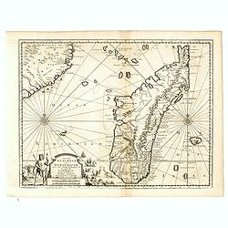
Ile de S. Laurens, ou Madagascar, située dans L'Ocean Ethiopien, sur les Côtes de L'Afrique.
Detailed map of Madagascar and Réunion. Published by Pieter van der Aa in "Galérie agréable du monde", completed in 1729. The Galerie was a sixty-six volume ...
Date: Leiden, 1729
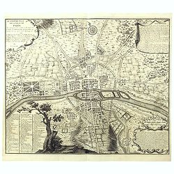
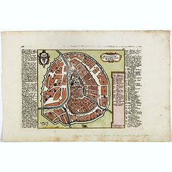
Quatrième plan de la ville de Paris . . .
Engraved plan of Paris, oriented to the North with a compass rose (upper part) and equipped with a double scale (400 geometrical steps and 1000 not common) with a brief c...
Date: Paris, 1729
![Lutece conquise par les François sur les Romains ou second plan de la ville de Paris [...] par M.L.C.D.L.M.](/uploads/cache/42141-250x250.jpg)
Lutece conquise par les François sur les Romains ou second plan de la ville de Paris [...] par M.L.C.D.L.M.
Engraved plan of Paris, published in "Traité de la police de Nicolas de Lamare". Oriented to the North with a compass rose and equipped with a double scale (40...
Date: Paris, 1729
Turkey in Asia: or Asia Minor &c.
Herman Moll's map of the Turkish Empire in Asia, published in London during the first half of the eighteenth century. It shows the eastern Mediterranean, including Crete ...
- $150 / ≈ €127
Date: London, ca 1729
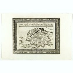
Projet de la forteresse de Nice.
Nice city plan of Nice at the Mediterranean sea. From the " Les forces de l'Europe, ou description des principales villes, avec leurs fortifications".
Date: Leiden, 1729
Russia or Moscovy with its Acquisitions &c.
Herman Moll's map of western Russia, or Muscovy, published in London during the first half of the eighteenth century. It shows the newly acquires lands taken from Sweden ...
- $200 / ≈ €170
Date: London, 1729

Virginie, Grande Region l'Amerique Septentrionale...
Pierre van der Aa used the old copper plate of Meurs and re-did the engraving, changed the large pictorial cartouche, a new scale of German and French leagues is provided...
Date: Amsterdam, 1729

Rare collection of costume plates.
Rare collection of costume plates published in Augsburg by the famous publishers Martin Engelbrecht, Ioh. Georg Hertel and the Jeremias Wolff Heirs.Composition :2 plates ...
Date: Augsburg, ca. 1730
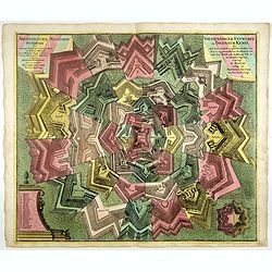
Architecturae Militaris Synopsis, ... / Vollstaendiger Entwurff der Ingenieur Kunst . . .
Decorative large sheet with elements of different types of fortress architecture and the name of the engineers or military architects: Blondel, Bourdin, Doegen, Borgsdorf...
- $650 / ≈ €552
Date: Augsburg, circa 1730
Geographica Nova ex Oriente gratiosissima, duabus tabulis specialissimis contenta, quarum una Mare Caspium..
Map of the Caspian Sea and the peninsula of Kamchatka (Jedso) in northeast Asia on one sheet.Separated by an attractive panel with figurative title cartouche, cherubs, an...
Date: Nuremberg, 1730
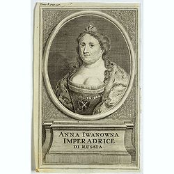
Anna Iwanowna Imperadrice di Russia.
Portrait of Anna Iwanowna (1693 – 1740), was regent of the duchy of Courland from 1711 until 1730 and then ruled as Empress of Russia from 1730 to 1740.
- $75 / ≈ €64
Date: France, ca. 1730

Colossus Monarchic. Statua Danielis
Fantastic double page allegorical map of a colossus figure representing the great world empires as Daniel interpreted in Nebuchadnezzar's dream. The warrior stands stolid...
Date: Augsbourg, 1730

Cazal. (Casale Monferrato)
A rare panoramic of Casale Monferrato in the Piedmont region. Engraved by Pierre Aveline (Paris, c.1656 - 23 May 1722). He was also a print-publisher and print-seller. H...
Date: Paris, 1690-1730
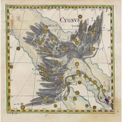
Cygnus.
Uncommon celestial print of Cygnus, published by Corbinianus Thomas in the Manuductio ad Astronomiam, Juxta modum Bayeri, Mathematici celeberrimi, concinnata, multis,…e...
Date: Frankfurt / Leipzig, c.1730

Carte du Canada ou de la Nouvelle France.
A later edition of Guillaume De l'Isle's map. It still includes the fictitious discoveries of Baron de Lahoutan: the legendary River Longue etc. The northwest corner of H...
Date: Amsterdam, 1730
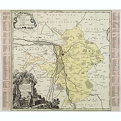
Praefectura Lipsiencis. . .
Detailed map centered around Leipzig with large pictorial cartouche and smaller cartouche of explanations. Alphabetical list of place names down both sides.
- $150 / ≈ €127
Date: Augsburg, 1730

Insularum Moluccarum Nova description.
Exquisite map of the famous Spice Islands based. This map was the first large-scale map of the region and depicts the islands which provided first the Portuguese and then...
Date: Amsterdam, 1730
Perspective des Isles de Palo Condoro à le regarde de 8 lieües di coté de Midy.
An attractive view of the Isle de Condor (Côn Son Island), located off the southern tip of Vietnam and a victualing point by European traders. In 1702, the English East ...
- $150 / ≈ €127
Date: Paris / Amsterdam, ca 1730
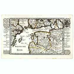
Der Nordischen Königreiche Süd=Oost Theil begreiffende Liefland Ingermanland und Finnland zum Theil.
Uncommon map published by Gabriel Bodenehr, who bought the Stridbeck copper plates in 1716, and continued publishing the Stridbeck Atlas: "Atlas Curieux," under...
- $400 / ≈ €340
Date: Augsburg, 1730
![[Lot of 10 maps] Carte Nouvelle de la Grande Tartary.](/uploads/cache/100265-(1)-250x250.jpg)
[Lot of 10 maps] Carte Nouvelle de la Grande Tartary.
Antique map of Asian Russia] Carte Nouvelle de la Grande Tartarie ou de l'Empire du Grand Cham. With 10 maps / views of Asian Russia- Carte Nouvelle de la Grande Tartari...
Date: Amsterdam, 1720 - 1730
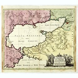
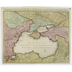
Nova Mappa Geographica Maris Assoviensis Vel De Zabache Et Paludis Maeotidis accurate aeri incis et in luce edita . . .
Striking map of the Sea of Azov with adjacent countries and the Strait of Kerch, with a decorative allegorical cartouche, showing the costumes of the indigenous people of...
Date: Augsburg, 1730
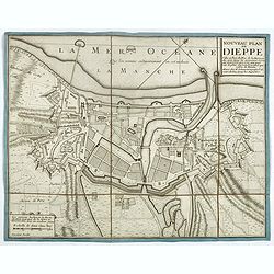
Nouveau plan de Dieppe, ville et port de mer de la Normandie.
Beautiful plan showing the fortified town of Dieppe and the suburbs of Barre and Pollet, engraved by Inselin. Beautiful example.
- $230 / ≈ €195
Date: Paris, ca. 1730
Asia Cum omnibus Imperiis, Provinciis, Statibus et Insulis. . .
A finely engraved and decorative mid-18th century map published in Augsburg, Germany and incorporating two large decorative title cartouches upper right and bottom left. ...
- $250 / ≈ €212
Date: Augsburg, 1730
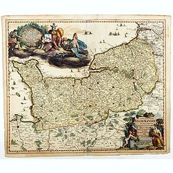
Nova et accurata Normandiae Ducatus Tabula . . .
This very rare map of Britany made by the Amsterdam publisher and Pieter Persoy (1675-1695). This among fourteen other maps are sometimes found in atlases by Frederik de ...
Date: Amsterdam, 1730
Moscow des Grossen Zaars Residenz.
A detailed plan of Moscow with an extensive description of the town and a numbered key 1-49 identifying important places. A coat of arms in the left corner.Afterwards, t...
- $400 / ≈ €340
Date: Augsburg, 1730
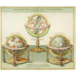
Sphaera Artificialium Typica repraesentatio.
Stunning engraving of terrestrial and celestial globes and armillary sphere, all with highly ornamented stands. Brief explanatory text. The plate was based on a design by...
Date: Augsburg, 1730
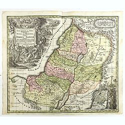
Terra Sancta vocata quae olim XII tribus . . .
Map of the Holy Land, among the 12 Tribes and divided into 6 provinces. In the upper left near the title cartouche Pharaoh's daughter discovers Moses in the River Nile. O...
Date: Augsburg, 1730
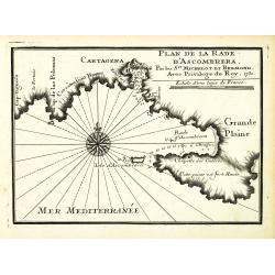
Plan de la Rade d'Ascombrera. . .
An attractive chart centered on Cartagena in Spain. With scale and large compass-rose. Dated 1730, with the privilege of the King. From : Recueil des Plusieurs plans des ...
- $300 / ≈ €255
Date: Marseille, 1730
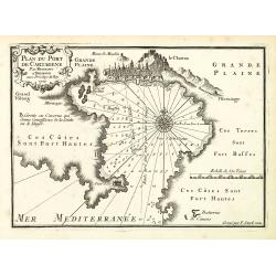
Plan du Port de Cartagène.
An attractive chart centered on the Bay of Cartagena. With scale and large compass-rose. Dated 1727, with the privilege of the King. From : Recueil des Plusieurs plans de...
- $375 / ≈ €319
Date: Marseille, 1730
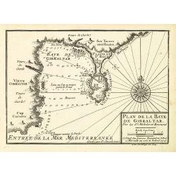
Plan de la Baye de Gibraltar.
An attractive chart centered on Gibraltar. With scale and large compass-rose. Dated 1727, with the privilege of the King. From : Recueil des Plusieurs plans des ports et ...
- $375 / ≈ €319
Date: Marseille, 1730
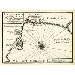
Plan de la Rade de Mayorque.
An attractive chart centered on Palma de Majorca in the Mediterranean. With scale and large compass-rose. Dated 1727, with the privilege of the King. From : Recueil des P...
- $600 / ≈ €510
Date: Marseille, 1730
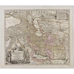
Imperii Persici in omnes suas Provincias . . . Exacte Divisi Nova Tabula Geographica. . .
Showing the eastern part of Turkey and Cyprus, Palestine, Persian Gulf, including Gulf of Oman, Caspian Sea, Iran and the north-west territories of India.Embellished with...
Date: Ausburg, 1730
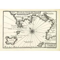
Plan du Golfe de Naples.
An attractive chart centered on the Gulf of Naples. Mount Vesuvius to the right. With scale and large compass-rose. Dated 1727, with the privilege of the King. From : Rec...
- $350 / ≈ €297
Date: Marseille, 1730
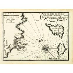
Plan du Port de Trapano et des isles Favouillane.
An attractive chart centered on Trapani on the west coast of Sicily in Italy. It is the capital of the Province of Trapani. The right the island of Favignana and Levanzo ...
- $300 / ≈ €255
Date: Marseille, 1730
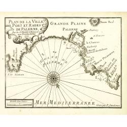
Plan de la Ville, Port et rades de Palerme. . .
An attractive chart centered on Palermo. With scale and large compass-rose. Dated 1727, with the privilege of the King. From : Recueil des Plusieurs plans des ports et ra...
- $250 / ≈ €212
Date: Marseille, 1730
![[Title page] A Monsieur Cassini de Thury . . .](/uploads/cache/47998-250x250.jpg)
[Title page] A Monsieur Cassini de Thury . . .
Title page by Cassini.
- $175 / ≈ €149
Date: Paris, ca. 1730
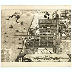
Plan de la Ville et du Chateau de Batavia en l'Isle de Iava / Ware affbeeldinge wegens het Casteel ende Stadt Batavia gelegen opt groot Eylant Java.
Detailed East-oriented plan of Jakarta former Batavia on Java / Indonesia. With bird's-eye view from sea side, various ships and a lion. Two inset keys with detailed desc...
Date: Leiden, 1730
Nouvelle Carte de la Petite Tartarie et la Mer Noire, montrant les Frontieres de l'Impératrice de Russie et de l'Empereur des Turcs, tant en Europe qu'en Asie, Dessigné selon la proposition de G. De L'Isle et d'autres Auteurs.
The Ukraine and the Black Sea in a fine impression with original 18th-c. hand-coloring.
- $1250 / ≈ €1062
Date: Amsterdam, 1730
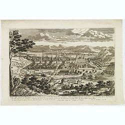
Bude Ville capitale de la Hongrie.
A rare panoramic town-view of the city of Budapest. Engraved by Pierre Aveline (Paris, c.1656 - 23 May 1722). He was also a print-publisher and print-seller. He probably...
- $400 / ≈ €340
Date: Paris, 1690-1730
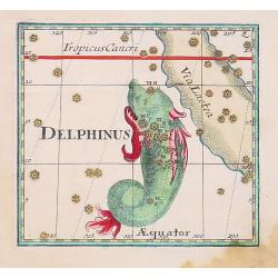
Delphinus.
Uncommon celestial print showing the constellation of Delphinus, published by Corbinianus Thomas in the Manuductio ad Astronomiam, Juxta modum Bayeri, Mathematici celeber...
Date: Frankfurt & Leipzig, c.1730