Browse Listings
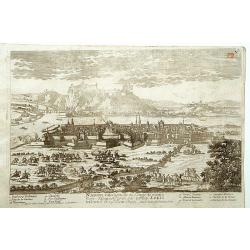
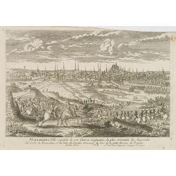
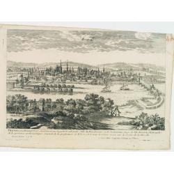
Namur.
A very RARE panoramic of the city of Namur, with a numbered legend in both lower corners.The plate is numbered in red pencil in upper right corner.Engraved by Pierre Avel...
- $150 / ≈ €127
Date: Paris, 1690-1720

Japonia Regnum.
It is the first map to correctly show Korea as a peninsula. The rare Covens and Mortier issue of this important map of Japan and Korea, originally published by Blaeu. Thi...
Date: Amsterdam, 1655 - 1720
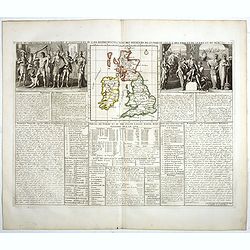
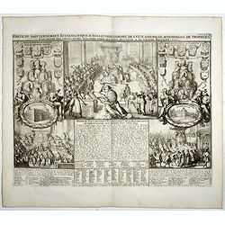
Carte du gouvernement d'Angleterre où l'on représente l'Etat des officiers de Guerre. . .
Decorative map on the British Isles, with idyllic scenes showing councils of the various military officers of the British Isles. Henri Abraham Chatelain (1684 – 1743) w...
- $50 / ≈ €42
Date: Amsterdam, 1720
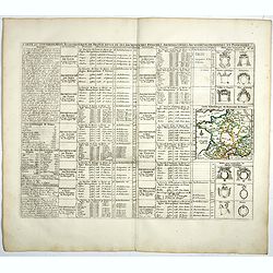
Carte du Gouvernement Ecclesiastique de France Divise en ses Archeveschez, Eveschez, Archidiaconnez, Archipretrez, Doyennez, et Parroisses.
This impressive plate provides a comprehensive list of the ecclesiastical divisions in the country with their corresponding coats of arms. A small inset map depicts the l...
- $55 / ≈ €47
Date: Amsterdam, 1720
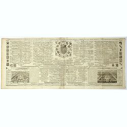
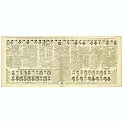
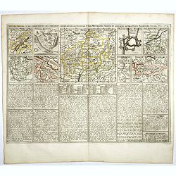
Carte genealogique de la famille Royale de Brunswick . .
A very detailed composite sheet with a genealogical table of the German royal families of Brunswick, Luneburg and Hanover, with descriptive French textZacharie Chatelain ...
- $50 / ≈ €42
Date: Amsterdam, ca. 1720
![Spiegel der Reden Voor de Wanhopende Actionisten. [Mirror for the reason of the despairing stockbrokers. ]](/uploads/cache/28094-250x250.jpg)
Spiegel der Reden Voor de Wanhopende Actionisten. [Mirror for the reason of the despairing stockbrokers. ]
Text page with copper engraving (150 x 100mm.) taken from Het groote tafereel der dwaasheid : vertoonende de opkomst, voortgang en ondergang der actie, bubbel en windnego...
Date: Amsterdam, 1720
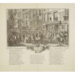
Rue Quinquempoix en l'année 1720. De regte afbeelding der wind negotie gehouden in de straat van Quinquempoix tot Parys.
A true picture of the wind trade of the rue Quinquempoix, Paris, in 1720, taken from "Het groote tafereel der dwaasheid : vertoonende de opkomst, voortgang en onderg...
Date: Amsterdam, 1720
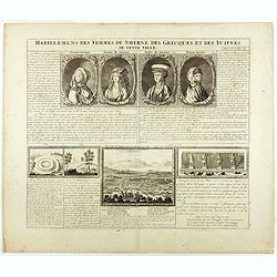
Habillement des femmes de Smyrnes, des Grecques et des Juifs de cette ville.
Four portraits of Smirne women in typical dress, each with a descriptive engraved text. From Chatelain's monumental 7 volume "Atlas Historique".Henri Abraham Ch...
Date: Amsterdam, 1720
Carte du gouvernement ecclesiastique d'Angleterre . . .
Elegant engraving of the ecclesiastical government of England, with an engraving showing three images: in the centre, an ecclesiastical assembly (Convocation of the Clerg...
- $100 / ≈ €85
Date: Amsterdam, 1720

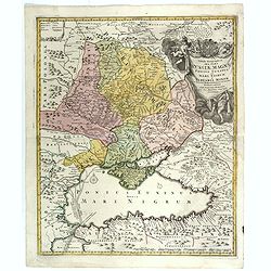
Tabula geographica Russiae Magnae pontus euxinus seu mare nigrum et tauriae regnum. . .
Decorative map of the Black Sea Region, with a large decorative cartouche. Shows Constantinople. Extends north to Moscow and Smolensko.
Date: Nuremberg, 1720
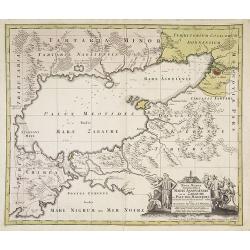
Maris Assoviensis vel de Zabache et Paludis Maeotidis. . .
A very detailed map showing the Black Sea, Azow and Rostow area. With a decorative allegorical cartouche, showing the costumes of the indigenous people of the region.
Date: Augsburg, 1720
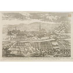
Nuremberg.
A very RARE panoramic view of the city of Nuremberg. The plate is numbered in red pencil in the upper right corner.Engraved by Pierre Aveline (Paris, c.1656 - 23 May 1722...
- $200 / ≈ €170
Date: Paris, 1690-1720
Ausbourg Ville Impériale d'Allemagne dans la Suabe.
A very RARE panoramic of the city of Augsburg. The plate is numbered in red pencil in the upper right corner.Engraved by Pierre Aveline (Paris, c.1656 - 23 May 1722). He ...
- $250 / ≈ €212
Date: Paris, 1690-1720
Fribourg Ville d'Allemagne Capitale du païs de Brisgaw.
A very RARE panoramic of the city of Fribourg. The plate is numbered in red pencil in the upper right corner.Engraved by Pierre Aveline (Paris, c.1656 - 23 May 1722). He ...
- $250 / ≈ €212
Date: Paris, 1690-1720
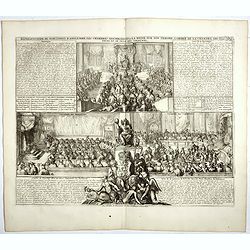
Représentation du parlement d'Angleterre, les chambres assemblées . . .
Engraving showing the British Parliament and an assembly before the King of England. From Chatelain's Atlas Historique, 1732-1739. In upper right margin: 'Tom. 7. No 26.H...
- $80 / ≈ €68
Date: Amsterdam, 1720
Treves en Allemend Trier.
A very RARE panoramic view of the city of Trier. The plate is numbered in red pencil in the upper right corner.Engraved by Pierre Aveline (Paris, c.1656 - 23 May 1722). H...
- $200 / ≈ €170
Date: Paris, 1690-1720
Carte genealogique des comtes de Dreux, des Seigneursde Beaussart . . .
Genealogical chart of the earls of Dreux, from Chatelain's monumental 7 volume "Atlas Historique". Henri Abraham Chatelain (1684 – 1743) was a Huguenot pastor...
- $50 / ≈ €42
Date: Amsterdam, 1720
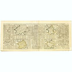
Nouvelle Carte des Differents Etats de la Monarchie Françoise Sous Iule Cesar, Sous les Rois de la Premiere, de la Seconde . . .
Four maps of France surrounded by historical and genealogical information to the history, chronology, ancient and modern genealogy of the french monarchy.Henri Abraham Ch...
- $75 / ≈ €64
Date: Amsterdam, 1720
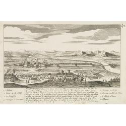
Philisbourg.
A very RARE panoramic view of the city of Philipsburg, including a numbered legend in both lower corners. The plate is numbered in black pencil in the upper right corner....
- $150 / ≈ €127
Date: Paris c.1720

Carte de l'Ile de Java.
An inset plan of Batavia and clearly indicated rice fields, mountains, forests, towns in profile and even elephants suggest the wealth of detail found on this map. Modele...
Date: Amsterdam, 1720
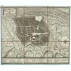
Plan de la ville de Treves.
Very rare town-plan of Trier by Didier Bugnon (1676-1736), geographer of the Duke of Lorraine. With numbered key (1-57) of the main buildings and buildings of the city. T...
Date: Paris?, 1720
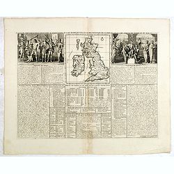
Carte Pour l'Introduction a l'Histoire d'Angleterre, ou l'on Voit son Premier Gouvernement, et l'Etat Abrege de cette Monarchie sous les Empereurs Romains, et sous les Rois Saxons.
The sheet includes a large inset map of Roman Britain including the English Channel and the western coast of France (200 x 255mm.). It also provides a wealth of informati...
- $200 / ≈ €170
Date: Amsterdam, 1720
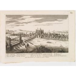
Ratisbonne.
A very RARE panoramic town view of the city of Ratisbonne, including a numbered legend in both lower corners. The plate is numbered in black pencil in the upper right cor...
- $200 / ≈ €170
Date: Paris c.1720
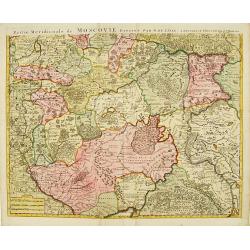
Partie Meridionale de Moscovie..
Centered on Moscow, including Azow in the bottom part of the map.The Amsterdam publishing firm of Covens and Mortier (1721 - c. 1862) was the successor to the extensive p...
- $300 / ≈ €255
Date: Amsterdam 1720
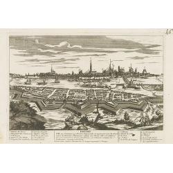
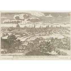
Breme.
A rare panoramic view of the city of Bremen, including a numbered legend in both lower corners.Published by the brothers Chéreau, active in Paris at rue st.Jacques au Gr...
- $200 / ≈ €170
Date: Paris c.1720
![Malines. [Mechelen]](/uploads/cache/13125-250x250.jpg)
Malines. [Mechelen]
A very RARE panoramic town view of Mechelen, including a numbered legend in the left lower corner.Published by the brothers Chéreau, active in Paris at rue st.Jacques au...
Date: Paris, c.1720
![Mayence Mentz en allemand .. [Metz]](/uploads/cache/13109-250x250.jpg)
Mayence Mentz en allemand .. [Metz]
A very RARE panoramic view of the city of Metz, including a numbered legend in the lower corners. The plate is numbered in red pencil in the upper right corner.Engraved b...
- $200 / ≈ €170
Date: Paris 1690-1720
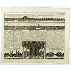
Description te vue de la Place d'Ispahan . . .
Pair of decorative views showing the Royal Palace at Isfahan (Esfahan) and the Royal Mosque of Abas the Great. From Chatelain's monumental 7 volume "Atlas Historique...
- $125 / ≈ €106
Date: Amsterdam, 1720
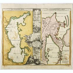
Das Caspische Meer / Das Land Kamtzadalie ...
Two maps on one sheet with the Caspian Sea on one side and northeastern Russia and Kamchatka on the other. The map of the Caspian Sea reflects the survey work of Russia�...
- $450 / ≈ €382
Date: Nuremberg, 1720
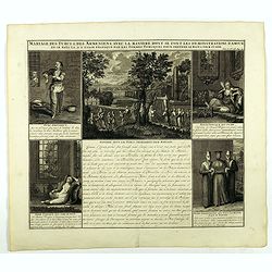
Mariage des Turcs & des Armeniens, avec la ma niere dont se font les demonstrations d'amour . . .
Showing the marriage rituals and lives of Turks and Armenians. Five engravings set round a text panel in French. From Chatelain's monumental 7 volume "Atlas Historiq...
- $150 / ≈ €127
Date: Amsterdam, 1720
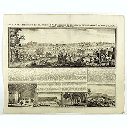
Vue et description de Bethleem et de Nazareth . . .
Decorative panoramic view of Bethlehem and Nazareth, among 3 other views of the Hall of the Annunciation and Church of Cana .From Chatelain's monumental 7 volume "At...
- $200 / ≈ €170
Date: Amsterdam, 1720
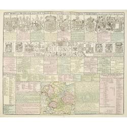
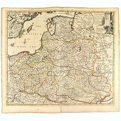
Kort Begryp van Duytsland, de drie Ryx Collegien in hunne Wapens en Zittingen. Kreits Verelingen en Aantekenigen door C. Specht't Utrectht.
Second state of this decorative table of family escutcheons, crests and coats of arms, for various German and Dutch princes and nobles of the 16th, 17th and 18th Centurie...
Date: Amsterdam, 1720
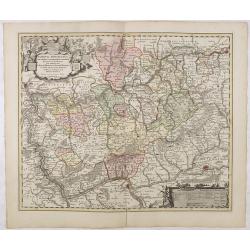
Nassovia Principatus Cum omnibus ei pertinentibus Comitatibus Dominiis ac Praefecturis ut et Confiniis intra Lahnun, Rhenum, et Moenum Flumina, ad situm verum exacte delineatus a Joh. Jac. Stetter. U.J.L. Idstenio-Nassovio . . .
Decorative map of the area between the rivers Rhine and Meuse, including Mainz, Koblenz, Frankfurt, Saarbrucken, etc.Includes an elaborate cartouche and coat of arms.The ...
- $150 / ≈ €127
Date: Amsterdam, 1720
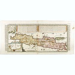
Carte de l'Ile de Java: partie Occidentale, partie Orientale, Dressée tout nouvellement sur les Mémoirs les plus exacts, Avec une Table des principales villes de cette Ile. . .
One of the finest large-scale maps of Java, giving good information regarding the VOC settlements An inset plan of Batavia and clearly indicated rice fields, mountains, f...
- $1500 / ≈ €1275
Date: Amsterdam, 1720
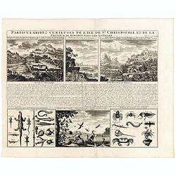
Particularitez Curieuses de l'Ile de St. Christophle et de la Province de Bemarin . . .
Six meticulously detailed and engraved scenes of the island of St. Kitts, also known as Saint Christopher, and the province of Bemarin, indigenous plants, animals, reptil...
Date: Amsterdam, 1720
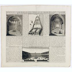
Description de la Celebre Mosquee de Com, Des Tombeaux Des Deux Derniers Rois de Perse qu'elle Renferme & du Grand Caravan-Serai De La Ville De Cachan Le Puls Magnifique de Tout L'Orient ...
Four views on one page with descriptive text showing the interior of the Mosquek, including the Sepulchre of Abas the Second and Sefy the First, along with the Tomb of th...
Date: Amsterdam, 1720
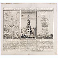
Description d'un des plus fameux temples des Chinois..
This impressive engraving is a wonderful example of Chatelain’s elegant plates.Divided in 3 panels, respectively showing the most important gods in the Chinese deities ...
Date: Amsterdam, ca. 1720
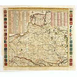
Carte De Pologne Avec La Chronologie Des Rois Et Des Ducs De Lithuanie, Ainsi Que Des Grands M. De L'Ordre Teutonique Les Evechez et Archeveches, et Les Armes Des Provinces . . .
Map of Poland with a key table to the towns, and 30 coats of arms on both sides, extending south the Black Sea. From Chatelain's monumental 7-volume "Atlas Historiqu...
- $1000 / ≈ €850
Date: Amsterdam, 1720
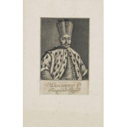
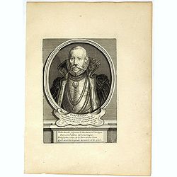
Mahomet V. Türkischer Kayser.
Portrait of Mahomet V. son of Mustapha II. succeeded in 1730, on the deposition of his uncle, Achmet III.Mahomet was more respectable for his pacific disposition, than hi...
Date: Germany, c. 1720
Carte du gouvernement militaire d'Angleterre où l'on représente l'état des officiers de guerre et celui des forces de terre et de mer.
Interesting sheet with a decorative map on the British Isles, with idyllic scenes showing councils of the various military officers of the British Isles, with descriptive...
Date: Amsterdam, 1720
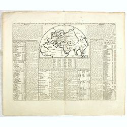
Carte pour servir à l'intelligence de l'histoire de la chronologie et de la géographie des empires des Assiriens, des Perses, des Egyptiens et des Chinois.
Interesting sheet with a map of the classical world showing the empires of the Assyrians, Persians, Egyptians and Chinese, with descriptive French text, from Chatelain's ...
Date: Amsterdam, 1720
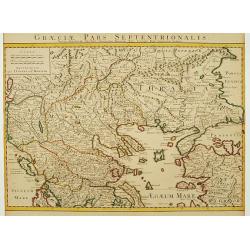
Graeciae Pars Septentrionalis..
Very decorative map illustrating the northern part of Greece and a small part of Turkey. Istanbul is represented on the right margin with its former names Byzantium and C...
Date: Amsterdam, 1720
Partie Meridionale de Moscovie. . .
Scarce map centered on Moscow including Azow and part of present-day Ukraine in the bottom part of the map. The map is based on Delisle's important map of the region with...
- $750 / ≈ €637
Date: Amsterdam, 1720

Carte des Principales Ports de Mer Bancs de sable &c: qui sont dans la Mer Rouge..
Some cities existed along the western coast of the Arabian peninsula, where they served as entrepots for transcontinental trade between Europe and Asia. Mecca, founded by...
Date: Amsterdam, 1720
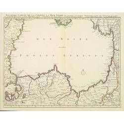
Seconde partie de la Crimee la Mer Noire. . .
The lower part of a set of two maps from the observations of Guillaume Delisle focusing on the Black Sea with wonderful detail of the surrounding regions. Includes Consta...
- $750 / ≈ €637
Date: Amsterdam, 1720

Nova tabula geographica complectens borealiorem..
A finely engraved pair of maps designed to be cut and joined together to provide a continuous coastline of North America from the Carolinas to Newfoundland and along the ...
Date: Amsterdam 1720
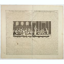
Viandes & breuvages des Turcs . . . / La manière dont les Turcs mangent . . .
Interesting sheet with a detailed views illustrating the lunch time in turkey, with descriptive French text, from Chatelain's monumental 7 volume Atlas Historique. In upp...
- $55 / ≈ €47
Date: Amsterdam, ca. 1720
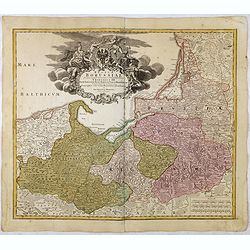
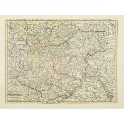
Regnum Borussiae gloriosis auspicijs Seerenissimi et Potentissimi Princip Friderici III Primi . . .
Map covering the region along the Baltic Sea from Prussia, Memel, to northern Poland, extending south to Poland, centered on Danzig, Konigsberg, Heilsperg, etc. Beautiful...
Date: Nuremberg, 1720
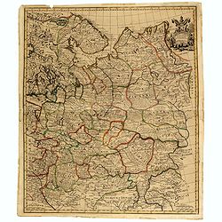
Tabula Geographica qua pars Russiae Magnae. . .
Homann's map is based upon Beauplan's general map of Ukraine but depicts the political changes of the preceding years. With decorative cartouches. Giving good detail alon...
Date: Nuremberg, 1720
Het Groote Tafereel der Dwaasheid.
AN EARLY ISSUE of this biting and vulgar satire on the Mississippi and South Sea Bubbles and an extraordinary visual record with 78 plates of the first banking crash, sho...
Date: Amsterdam, 1720
Het Groote Tafereel der Dwaasheid, vertoonende de opkomst, voortgang en ondergang der Actie, Bubbel en Windnegotie, in Vrankryk, Engeland, en de Nederlanden, ...
FIRST ISSUE of this biting and vulgar satire on the Mississippi and South Sea Bubbles and an extraordinary visual record with 78 plates of the first banking crash, show...
- $7500 / ≈ €6374
Date: Amsterdam, 1720
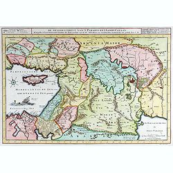
40 De gelegentheyt van ’t Paradys en ’ t Landt Canaan.
Bottom right:' t Amsterdam uytgegeven door Cornelis Dankerts voor aen op de Nieuwendijck in den Atlas met Previlegie.This Cornelis Danckerts ( the spelling of his name di...
- $250 / ≈ €212
Date: Amsterdam, 1720
Carte des Grisons et des Communautez qui Composent leurs Ligues, les Etats de St. Gal, Neuchastel, Geneve et Quelques Autres Etats Alliez des Suisse.
This finely engraved sheet provides the history of various cities and regions allied with Switzerland at the beginning of the eighteenth century. The top section of the s...
- $150 / ≈ €127
Date: Amsterdam, 1720
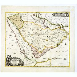
Arabiae Felicis, petrae et desertae.
A very striking map with a finely decorated title cartouche, published by Valk & Schenk, utilizing Jansson's original plate. Interestingly, this map uses the names th...
Date: Amsterdam, 1720

Nostre Dame de Lorette.
A very RARE panoramic of Lorette and the church, including a numbered legend in both lower corners.The plate is numbered in black pencil in upper right corner.Published ...
Date: Paris c.1720
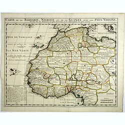
Carte de la barbarie, Nigritie et de la Guinée avec les pays voisins . . .
This great map of western Africa is based on Guillaume Delisle's map. It covers from the Barbary coast to below the equator. There is a mass of geographic detail and nota...
Date: Amsterdam, 1720
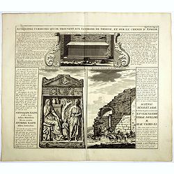
Antiquez curieuses qui se trouvent aux environs de Smyrne, et sur le chemin d'Ephese.
Folio sheet describing and depicting ancient Greek monuments and ruins in Smyrna (Izmir). From Chatelain's monumental 7 volume "Atlas Historique". Henri Abraham...
Date: Amsterdam, 1720
Ticho-Braché . . .
Uncommon portrait of Tycho Brahe, (1546 - 1601) engraved and published by Étienne Jehandier Desrochers ( Lyon 1668 - Paris 1741). Brahe was a Danish astronomer whose wor...
- $150 / ≈ €127
Date: Paris, 1720

Beschrijving Gezicht van den Ykant af bezyden den Schreiers hoex Toren langs de Keulsche en Geldersche Kaei naer de Nieuwe Markt
This large engraving (560x920mm.) comes from a are series of 25 beautiful large views of Amsterdam and gives a colorful picture of the life and business of the city at th...
Date: Amsterdam, ca. 1720
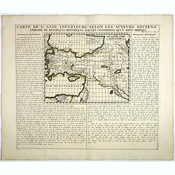
Carte De L'Asie Inferieure Selon Les Auteurs Anciens, Enrichie de Remarques Historiques sur les Changemens qui y sont arrivez.
Text page with inset map (220x269.mm.) of Turkey, including Cyprus from Chatelain's monumental 7 volume "Atlas Historique". Henri Abraham Chatelain (1684 – 17...
Date: Amsterdam, 1720

Carte des Indes, de la Chine & des Isles de Sumatra, Java &c..
This fine and quite detailed general map extends from northern Japan to Timor and from India to New Guinea.There are very good details of towns and trade routes in modern...
Date: Amsterdam, 1720
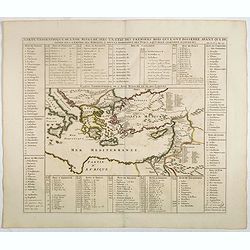
Carte geographique de l'Asie mineure avec un etat des premiers rois. . .
Map of the Mediterranean. This impressive engraving is a wonderful example of Chatelain’s elegant plates from his "Atlas Historique, Ou Nouvelle Introduction A L�...
- $120 / ≈ €102
Date: Amsterdam, ca. 1720
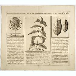
Description, figure et qualité de l'arbre, du café, avec la manière de le cultiver et d'en cueillir le fruit.
Decorative copperplate engraving showing a coffee tree, plant and fruit, with an lengthy description about its growing process.From Chatelain's monumental 7 volume "...
- $75 / ≈ €64
Date: Amsterdam, 1720
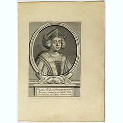
Christophe Colomb . . .
Fine portrait of Christopher Columbus (c.?1451 – 1506) engraved and published by Étienne Jehandier Desrochers ( Lyon 1668 - Paris 1741).Christopher Columbus was an Ita...
- $75 / ≈ €64
Date: Paris, 1720
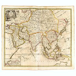
A New Map of Asia from the latest Observations Most Humbly Inscrib'd to the Right Honbl. George Earl of Warrington &c.
Fine map of Asia, with decorative title cartouche flanked by two figures in Asian dress, along with flora and fauna of the continent., based on the work of Guillaume De L...
Date: London, 1721
![[Set of 2 maps of Caspian Sea.] Carte marine de la Mer Caspiene. Levee suivant les ordres de S.M. Czariene, P](/uploads/cache/20009-250x250.jpg)
[Set of 2 maps of Caspian Sea.] Carte marine de la Mer Caspiene. Levee suivant les ordres de S.M. Czariene, P
Guillaume de l' Isle (1675-1724), Royal Geographer, was the most influential cartographer of the first quarter of the 18th century. ' Atlas de Géographie' (1700-12), pos...
- $350 / ≈ €297
Date: 1721

A Map of Turky, Arabia And Persia. Corrected from the latest Travels. . .
FIRST EDITION - Fine Turkish Empire map centered on Saudi Arabia, Cyprus and the Mediterranean Sea. Dated 1711, "Sold by John Senex at the Globe aga inst St. Dunstan...
- $1750 / ≈ €1487
Date: London, 1721
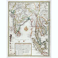
Les Indes Orientales sous le Nom de queles est compris L'Empire du Grand Mogol, Les Deux Presqu'Isles Deca et de la Le Gange, Les Maldives, et L'Isle de Ceylan . . . 1721
Rare map of the region including India, Malaysia with "Sincapur", Thailand, Sumatra, the eastern part of Java. The map is extended in the right border with Maca...
Date: Paris, 1721

Carte historique de la France, et l'Angleterre depuis la naissance de Jésus-Christ jusqu'à l'an 1700, qui contient en abrégé les événements ...
A rare wall map showing a chronological tree of French and English historical events from the year of the birth of Christ until 1700. The map is prepared by Jérôme Andr...
Date: Paris, c. 1721
Poland and other the Countries belonging to the Crowne According to the Newest Observation 1719
Fine map of the Polish Empire in a second edition of the map, which had been published by Morden & Browne in 1710. The remnants of the earlier address, are still slig...
- $1200 / ≈ €1020
Date: London, 1721
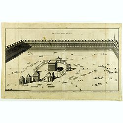
Le Temple de la Mecque.
Striking view of the Temple at Mecca, showing the Kaaba at the center of Islam's most sacred mosque, that is Al-Masjid Al-?aram, in Mecca, Hejaz, Saudi Arabia.The engravi...
- $1000 / ≈ €850
Date: The Hague, Isaac Vaillant, 1721
Moscovey in Europe from the latest Observations . . .
Fine, highly detailed map of the regions of European Russia by John Senex. Each region is depicted in original outline color, and a small decorative cartouche is in the t...
- $450 / ≈ €382
Date: London, 1721
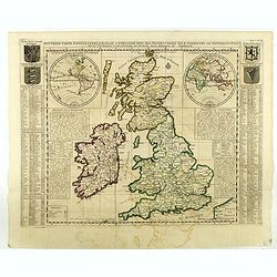
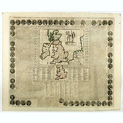
Nouvelle carte d'Angleterre, d'Ecosse et d'Irlande, avec des instructions ..
Striking large folding map of the British Isles, with large insets of the Eastern and Western Hemispheres and the coats of arms for England, Ireland, Scotland and Wales. ...
- $200 / ≈ €170
Date: Amsterdam, 1721
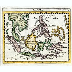
L'india.
This small Italian map of of South East Asia, with Indonesia, , Malacca is based on the cartography of Guillaume Delisle. Japan is shown attached to Ter di Yesso (Hokkai...
Date: Venice, c.1722
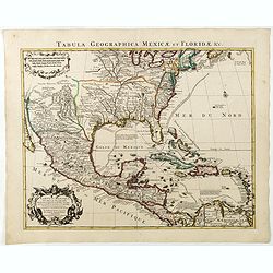
Carte du Mexique et de la Floride, des terres angloises et des isles Antilles, du cours et des environs de la rivière Mississipi. . .
A Dutch edition of De L'Isle's map. It was the first printed map to portray accurately the course and mouth of the Mississippi River. Showing the explorations of d'Ibervi...
Date: Amsterdam, 1722
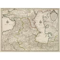
Carte des Pays Voisins de la Mer Caspiene dressee pour l' usage du Roy. . .
The map shows the area east of the Caspian Sea, including parts of Kazakhstan, Turkmenistan, Uzbekistan, and northern Iran. The area eastward from the Caspian is marked '...
- $750 / ≈ €637
Date: Paris, 1723
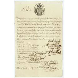
Very rare share in the Ostend Company. (299)
Upper left hand corner share number "299" in manuscript. In top emblem of the Company in copper engraving. Text: " De Directeurs van de generale Keijserlij...
Date: Antwerp / Ostend, 1723
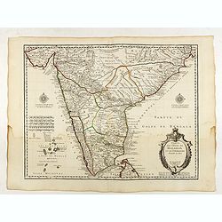
Carte des Cotes de Malabar et de Coromandel..
Detailed and attractive map of India and the northern tip of Sri Lanka. With decorative title cartouche and two compass roses.Rare edition with address : A Paris chez l�...
Date: Paris, 1723
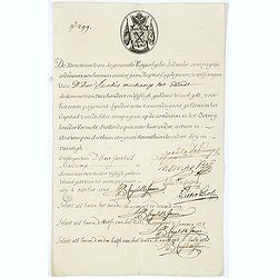
Very rare share in the Ostend Company.
Upper left hand corner share number 4526 in manuscript. In top emblem of the Ostend Company in copper engraving. Text: De Directeurs van de generale Keijserlijche- Indis...
Date: Antwerp / Ostend, 1723

Plan de la ville de Malthe ses Forts, ses Nouvelles Fortiffications. . .
Detailed plan of Valletta. In upper right corner a key (A-Z & 1-32) to the principal places in town. Prepared by N.de Fer and re-issued by Danet.
Date: Paris, 1723