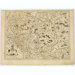
![.[Germany and Poland]](/uploads/cache/33862-250x250.jpg)
.[Germany and Poland]
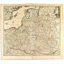
Wood block printed map and one of earliest printed representation of Germany, Poland, The Low Countries, Austria and Switzerland prepared by Martin Waldseemüller. Based o...
Date: Vienna, Trechsel, G., 1525 -1541
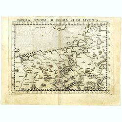
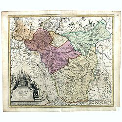
Tavola nuova di Prussia et di Livonia.
Uncommon first edition of this early map of the region from Pomerania to Livonia, includes a portion of Estonia, and coastal detail on the Baltic Sea with a small section...
- $400 / ≈ €350
Date: Venice, Vincenzo Valgrisi, 1561
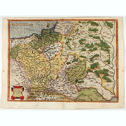
POLONIAE finitimarumque locorum descrip:tio. Auctore WENCESLAO GRODECCIO. Polono.
Ortelius' map of Poland, being a close copy of Grodecki / Pograbka's map of 1558/62 map, itself based on Wapovsky 1526 (Karrow 56) With Latin text on verso, a state 1 and...
- $1200 / ≈ €1049
Date: Antwerp, 1587

POLONIAE finitimarumque locorum descrip:tio. Auctore WENCESLAO GRODECCIO. Polono.
Ortelius' map of Poland, being a close copy of Grodecki / Pograbka's map of 1558/62 map, itself based on Wapovsky 1526 (Karrow 56) With Latin text on verso, a state 4 and...
Date: Antwerp, 1592
Oswiec. et Zatorien. Ducatus.
Miniature map of Poland from "Il Theatro del Mondo," which was a plagiarized version of Ortelius' pocket atlas published specifically for the Italian market by ...
Date: Brescia, 1598
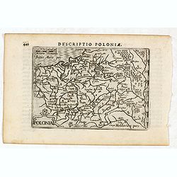
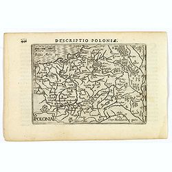
Descriptio Poloniae / Polonia.
A rare miniature map of Poland. Title cartouche on the lower left corner.First published in 1598 in his Caert-Thresoor, the plates were executed by the most famous engrav...
- $400 / ≈ €350
Date: Amsterdam, Cornelis Claes, 1606
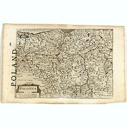
Polonia.
A miniature map of the Polish-Lithuanian Commonwealth, published by Petrus Bertius, in Amsterdam at the beginning of the seventeenth century. It features a small strap-wo...
Date: Amsterdam, 1606
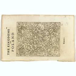
Polonia. (With text page)
Early map of Poland (168x250mm.) printed on a text page, together with another giving a description of the region in English.
- $150 / ≈ €131
Date: Amsterdam, 1612
Polonia et Silesia. (With text page)
Early map of Poland. With English title above the map and an description of the region in English on verso.
- $250 / ≈ €219
Date: Amsterdam, 1612

A Newe mape of Poland Done into English by I.Speede.
A wonderful map of Poland. Incorporated into Speed's 'Prospect Of The Most Famous Parts Of The World.' Includes birds-eye views of Cracow, Dantzick, Posna, Crossen, Sando...
Date: London, 1627
A Newe mape of Poland Done into English by I.Speede.
A wonderful map of Poland. Incorporated into Speed's 'Prospect Of The Most Famous Parts Of The World'. Includes birds-eye views of Cracow, Dantzick, Posna, Crossen, Sando...
Date: London, 1627

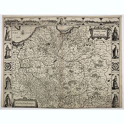
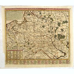
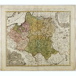
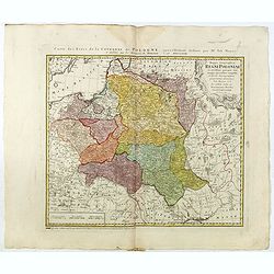
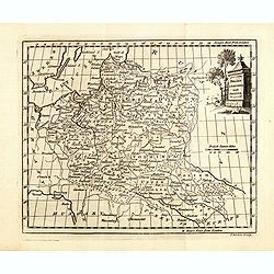
Tabula nova Poloniae et Silesiae.
Second state, dated 1630 underneath the title. A finely engraved carte á figures with cartouche representing in the four corners of the map : Kings ( on the left side Sig...
Date: Amsterdam, 1630
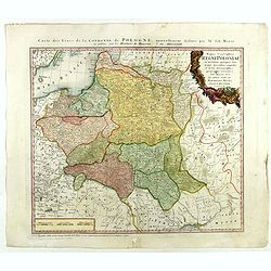
Polonia et Silesia.
Fine and important map of Poland, including Warsaw, Krakow, Oppeln, Breslau, Gnezna, Graudenz, Lublin etc.Mercator was born in Rupelmonde in Flanders and studied in Leuve...
Date: Amsterdam, 1633

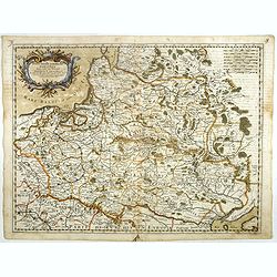
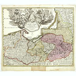
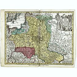
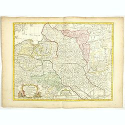
Polonia regnum et Silesia ducatus.
Very decorative map of Poland embellished with two cartouches and two coats of arms surmounted by cherubs and female figures. Showing the region from the Oder east to Pod...
Date: Amsterdam, 1638
![Magni Ducatus Lithuaniae. . . (together with] Campus Inter Bohum et Borystenem. . .](/uploads/cache/49232-250x250.jpg)
Magni Ducatus Lithuaniae. . . (together with] Campus Inter Bohum et Borystenem. . .
Six sheet wall map of Lithuania and parts of Poland, Russia, Ukraine, Latvia, etc., extending to Cracow, Kyiv, Warsaw, Riga, Konigsberg, Danzig, Leopolis, etc.This is the...
Date: Amsterdam, 1658
Stati della Corona di Polonia Divisa nella sue Principali Provincie e Palatinati da Guglielmo Sansone. . .
Rare map of Poland, Lithuania and the Ukraine. Copies of his first edition of 'Mercurio Geografico', published in 1674, do not contain a map of Poland. Only added in late...
Date: Rome, 1678

Le Cours de l'Elbe et de l'Oder où sont les Electorats de Saxe et de Brandebourg, les Duchés de Mekelbourg et de Pomeranie. . .
A detailed and scarce map showing the rivers Elbe and Oder in Germany and Poland. Dark engraving.This is one sheet of the four sheet wall map by Pierre Du Val entitled: &...
Date: Paris, 1684
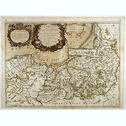
La Prussia Divisa in Reale Che Appartiene al Ré Di Polonia et in Ducale Che Spetta all'Elettore Di Brandeburgo. Da Giacomo Cantelli Da ...
In the upper left-hand corner a large title cartouche with a dedication to Cardinal Denhoff. The map is dated 1689.The cartographer was Giacomo Cantelli (1643-1695) who w...
Date: Rome, 1689
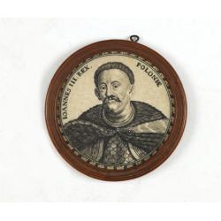
Ioannes III. Rex. Poloniae (Portrait of Johann III. Sobieski)
On verso a text in brown ink "1674 Giovanni Sobieski Gran Maresciallo della Polonia, che poscia lo fece suo Re, perchè a Cokrim vinse li Turchi, e la liberò dai trib...
Date: Ulm, ca. 1690
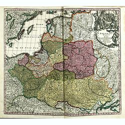
Nouvelle carte du royaume de Pologne, divisée selon..
Chatelain's map of Poland. The title is in two lines across the map. On bottom border appears an index to the map's contents. At the top of the map appear historical rema...
- $750 / ≈ €656
Date: Amsterdam, 1719
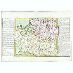
Les Estats de la Couronne de Pologne.
Lovely small map of Poland with title cartouche and a panel in the upper right corner listing local rulers.From Le Nouveau et Curieux Atlas Geographique et Historique.. b...
- $200 / ≈ €175
Date: Paris, 1719
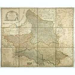
Regnum Borussiae gloriosis auspiciis serenissimi et potentissimi princip. Friderici III primi Borussiae regis march. et elect. Brandenburg inauguratum die 18 Jan...1701.
Map covering the region along the Baltic Sea from Prussia to northern Poland, with the city of Kaliningrad (Königsberg), Danzig, and Heilsperg, etc. With a large title-ca...
- $700 / ≈ €612
Date: Nuremberg, 1720
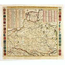
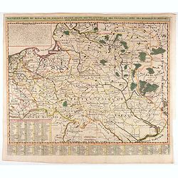
Carte De Pologne Avec La Chronologie Des Rois Et Des Ducs De Lithuanie, Ainsi Que Des Grands M. De L'Ordre Teutonique Les Evechez et Archeveches, et Les Armes Des Provinces . . .
Map of Poland with a key table to the towns, and 30 coats of arms on both sides, extending south the Black Sea. From Chatelain's monumental 7-volume "Atlas Historiqu...
- $1000 / ≈ €874
Date: Amsterdam, 1720
Poland and other the Countries belonging to the Crowne According to the Newest Observation 1719
Fine map of the Polish Empire in a second edition of the map, which had been published by Morden & Browne in 1710. The remnants of the earlier address, are still slig...
- $1200 / ≈ €1049
Date: London, 1721
Regni Poloniae, ducatus Mazoviae et province Cujaviae / descriptio emendata per R. & I. Ottens
Very rare map of Poland Lithuania and Ukraine, etc. Engraved by A. Schut.Joachim Ottens (1663 - 1719) and his sons Renier and Joshua were prominent Dutch booksellers and ...
Date: Amsterdam, 1725
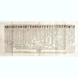
Nouvelle carte genealogique des souverains et des familles illustres aliez a la maison ou aux decendans de la famille roialle de Piaste roi de Pologne. . .
A two sheet engraving of the genealogical family tree of Poland from 804 AD to the time of publication. The tree extends throughout Europe and is headed by the arms of 30...
- $150 / ≈ €131
Date: Amsterdam, 1719-1732
Nouvelle carte du royaume de Pologne, divisée selon..
Chatelain's map of Poland. The title is in two lines across the map. At the bottom border, an index to the map's contents appears. At the top of the map, historical remar...
Date: Amsterdam, 1735
Poloniae Regnum ut et Magni Ducatus Lithuaniae . . .
Detailed map of Poland and the Baltic regions, extending in the south to Ukraine and northern Hungary.Here in its second state, now with added letters to the border scale...
Date: Augsburg, 1735
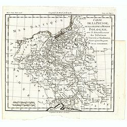
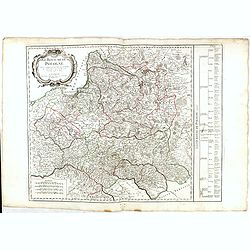
La Pologne.
An unusual 1752 Buffier copper engraved map of Poland. The map also covers Lithuania, part of Russia, Hungary, a portion of Ukraine, as well as a part of Romania. A decor...
Date: Paris, 1753
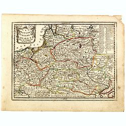
Mappa Geographica Regni Poloniae ex novissimis quotquot sunt mappis specialibus composita et al L.L. Stereographicae projectionis revocata a Tob. Mayero. . . .
Decorative map of Poland after Tobias Mayer who was based on Barnikel's map of Curland (1747) and Jan Nieprzecki's map of Lithuania (1749).Poland extends from Glogau and ...
Date: Nuremberg, 1757
![Partie septentrionale du cercle de Haute Saxe [...] Brandebourg.](/uploads/cache/64110-250x250.jpg)
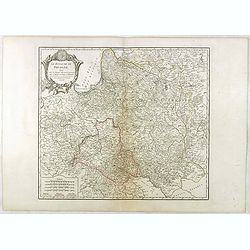
Partie septentrionale du cercle de Haute Saxe [...] Brandebourg.
Finely and crisply engraved map of north eastern part of Germany, including part of Poland. With inset map of Brandenburg. Map by Giles Didier Robert De Vaugondy with era...
Date: Paris, c. 1760
![Partie septentrionale du cercle de Haute Saxe [...] Brandebourg.](/uploads/cache/33211-250x250.jpg)
Partie septentrionale du cercle de Haute Saxe [...] Brandebourg.
Finely and crisply engraved map of north eastern part of Germany, including part of Poland. With inset map of Brandenburg. Map by Giles Didier Robert De Vaugondy with era...
Date: Paris, c. 1760
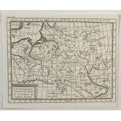
![[Mer Baltique]](/uploads/cache/37796-250x250.jpg)
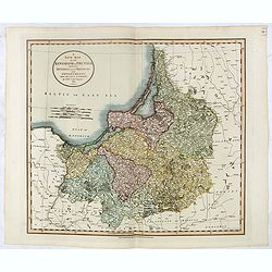
[Mer Baltique]
Detailed map of Northern part of Poland with Danzig, from his "Atlas moderne ou collection de cartes...".map N° 15.
- $300 / ≈ €262
Date: Paris, 1762
Royaume de Pologne.
Fine map of Lithuania, Prussia and Poland with an explicatif text to both sides. From Jean Baptiste Louis Clouet (1730-1790) influential "Géographie Moderne" fi...
Date: Paris, ca. 1767
Mappa Geographica Regni Poloniae ex novissimis quotquot sunt mappis specialibus composita et al L.L. Stereographicae projectionis revocata a Tob. Mayero. . . .
Late Tobias Mayer detailed map Polish edition, updated in order to show the borders of the kingdom of year 1772 after the division of the territory.Mayer's map extends fr...
- $750 / ≈ €656
Date: Nuremberg, 1773
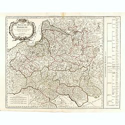
Mappa Geographica Regni Poloniae ex novissimis quot quot sunt mappis. . .
A map of Poland, Lithuania and Belarus, first published in 1750 by Homann Heirs, and now re-issued in 1773. Coastline includes all between Riga and Gdansk. Map is based o...
Date: Nuremberg, 1773
Polonia regnum ut et magni Ducat Lithuania. . .
Miniature map of Poland, a reduction of the appropriate part of Seutter's folio map. Engraved by Tobias Conrad Lotter.From Atlas Minor, here published by Johann Martin Wi...
- $450 / ≈ €393
Date: Augsburg, J.M.Will, 1778
Carte de la Prusse, de la Grande et Petite Pologne, avec le démembrement des Palatinats de Cracovie et Sandomirz, faisant aujour d'hui partie de la Lodomerie.
A map of the Polish territories by Louis Brion de la Tour, from the work "Histoire universelle depuis le commencement du monde jusqu a present" published in Par...
Date: Paris, 1779

La Pologne Dressée sur ce qu'en ot donné Starovolsk, Beauplan, Hartnoch. . .
Large map of Poland, Lithuania, Belarus and part of Ukraine. The map is filled with detail and decorated with a title cartouche flanked by mythological figures.According ...
Date: Paris, 1773 - 1780
Poland Lithuania and Prussia.
Uncommon miniature map of Poland, Lithuania and the Ukraine, engraved by Thomas Kitchin - with his signature in lower right bottom.
Date: London, 1782
Royaume de Pologne.
Detailed map encompassing present-day Poland. The table provides a breakdown of the sub-regions of the Polish Crown.Venetian edition of the map by R. de Vaugondy, to whom...
- $350 / ≈ €306
Date: Venice, 1776 - 1784
Royaume de Pologne.
Detailed map encompassing present-day Poland.Venetian edition of the map by R. de Vaugondy, to whom Santini gives credit in the cartouche.From "Atlas Universel"...
Date: Venice, 1776 - 1784
Carte générale de la Pologne : avec ses différens démembremence par les puissances partageantes en 1773 et 1795 / dessinée et dressée par Mariaval. . .
Very rare map of Poland, engraved by Tardieu l’Ainé, active at rue de Sorbonne 385.
Date: Paris, ca. 1795
Karte von Polen.
An attractive map of Poland. With a decorative title cartouche in the upper left-hand corner. Engraved by Ant. Amon. Franz Johann Josef von Reilly (Vienna 18 august 1766 ...
- $950 / ≈ €831
Date: Vienna, 1796
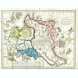
Le Royaume De Pologne, divise selon les Partages faits en 1772, 1793 et 1795, etnre la Russie, la Prusse et l'Autriche . . .
The uncommon later edition of this detailed map of Poland, showing the lands lost to Russia, Prussia and Austria in 1772, 1793 and 1795. with a color key added underneath...
Date: Paris, ca. 1796
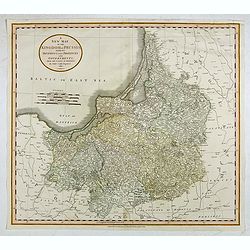
A New Map of the Kingdom of Prussia with its Divisions Into Provinces and Governments . . .
Highly detailed regional map of Prussia, including the Baltic regions and part of Poland, from Cary's Universal Atlas, one of the finest atlases of the period.
- $275 / ≈ €240
Date: London, 1799
La Pologne avec le dernier partage.
Uncommon map of Poland and Lithuania. Engraved by Alexandre Blondeau (1799-1828), with Brezesci in the center of the map.From "Atlas universal pour la géographie de ...
- $200 / ≈ €175
Date: Paris, Hyacinthe Langlois, 1799
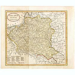
Poland from the best authorities.
Detailed map of Poland from "A New Geographical, Historical, and Commercial Grammar", by William Guthrie. William Guthrie (later engraver for Carey) London, UK....
Date: London, 1805
La Pologne Dressée sur ce qu'en ont donné Starovolsk, Beauplan, Hartnoch. . .
This is a late edition of the De L'Isle copper plate with a date of 1806. The copper plate was used many times and has several erased addresses. This one with address &qu...
- $750 / ≈ €656
Date: Paris, 1806
A New Map of the Kingdom of Prussia with its Divisions Into Provinces and Governments. . .
A fine map by John Cary of Prussia, in what is now northern Poland and Lithuania. John Cary was considered "the most representative, able and prolific of English car...
- $250 / ≈ €219
Date: London, 1811
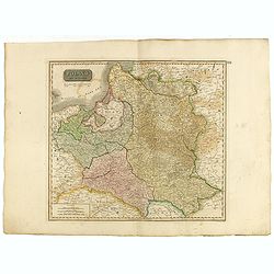
Poland As Divided.
This map covers Poland following Napoleonic Wars and the treaties of the 1815 Congress of Vienna.This map was first published in Thomson's New General Atlas of 1814. John...
Date: Edinburgh, 1817

Province de Pologne contenant 22 Col. une M.on Prof 5 Pen. 2 Nov. 6 Rés. 30 Maisons 1050 Jésuites.
Rare map of Poland from "Atlas Universel indiquant les établissemens des Jésuites: avec la manière dont ils divisent la terre, suivi desévénemens remarquables de leu...
Date: Paris, Ambroise Dupont , 1826
Reino de Polonia ò sea la parte unida a la Rusia por el repartimiento de 1795 que conserva el nombre de aquel antiguo reino.
Uncommon Spanish map of Poland from "Coleccion de mapas geograficos antiguos y modernos de autores clascicos", published by José Torner in Barcelona in 1831.R. ...
Date: José Torner, Barcelona, 1831
Carte des Etats de Pologne et du Grand Duché de Lithunanie.
Uncommon map of Poland prepared by Sanson and revised by Eustache Hérisson (1759-18.. ) and engraved by Cordier. The map was published by the last family member of the Je...
Date: Paris, Jean, 1831
Carte Routière de la Pologne indiquant les partages de ce Royaume…
Carte Routière de la Pologne indiquant les partages de ce Royaume qui ont été faits depuis 1772, 1795 &a". Map prepared by Hérisson and published by Basset. Incl...
Date: Paris, Basset, 1831
Karta öfver Preussiska riket.
An very rare map of Eastern part of Germany, with Pomerania and part of present-day Poland with Swedish text. This is an updated version of his map of 1820 and is now dat...
Date: A. Wiborgs förlag, Stockholm, ca. 1848

Mapa Polski i Krajów Osciennych - Wydanie trzecie. Opracowal Stanislaw Max. Wydani M. Arcta.
‘The Birth of Modern Poland on a map’ - an excellent wall map of Poland and surrounding regions, published in Warsaw near the end of World War I, when Poland’s fate was u...
Date: Warsaw, [H. Sklodowski], 1918
