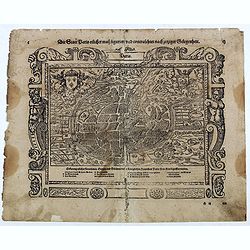
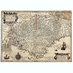
![Terta Etas Mundi. Foliu CX [With view of Metz]](/uploads/cache/46260-250x250.jpg)
Terta Etas Mundi. Foliu CX [With view of Metz]
The Latin text page is illustrated with a depictions of Kings, Noble men and women and scientists, among Eustace (Eustachius) a Roman soldier and martyr, appears as a bea...
- $450 / ≈ €395
Date: Nuremberg, 12 July 1493
![Parisius & Maguncia. [Paris & Munich] Folio XXXIX](/uploads/cache/29718-250x250.jpg)
Parisius & Maguncia. [Paris & Munich] Folio XXXIX
Imaginary view of Paris and on verso Munich : however the earliest obtainable views of this period.In the forground a large vessel, who was the symbol of the powerful cor...
Date: Nuremberg, 12 July 1493
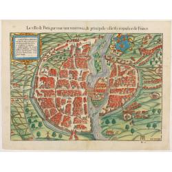
La ville de Paris, par tout tant renommée & principalle ville du royaulme de France.
Very early birds-eye view of Paris. From his Cosmographia, that great compendium of Renaissance knowledge. An exciting print.Engraved by Hans Rudolf Manuel-Deutsch(1525-1...
Date: Bâle, H. Petri, 1552
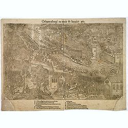
Orleans assiegé au mois de Janvier. 1563.
Rare copper engraved view of the siege of Orleans in January 1563, engraved by Jean Jacques Perrissin, (1536 - before 1611).Print from the suite "The Wars, Massacres...
- $100 / ≈ €88
Date: Geneva, ca. 1570
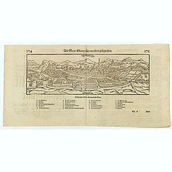
Die statt Montpellier . . .
Panoramic view of Montpellier by Sebastian Münster. Below the engraving a letterpress key. From the German edition of Sebastian Munster's Cosmography, "Cosmographey...
Date: Basel, Heinrich Petri, 1574
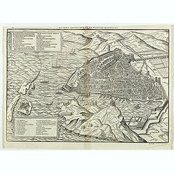
Le vray portraict de la Ville de Marseille.
Fine wood cut bird's-eye view of Marseille. Decorated with several ship in the harbour and on the sea. To the left two keys describing the main buildings and places. Publ...
Date: Paris, 1575
Die Statt Paris etlicher mass figuriert und contrafehtet nach jetziger Gelegenheit.
Published in the "Universal Cosmography" of S. Münster. Text in German. Under the legendary plan in German A to G. It is framed by a border composed of foliage...
- $200 / ≈ €176
Date: Bâle, H. Petri, 1578
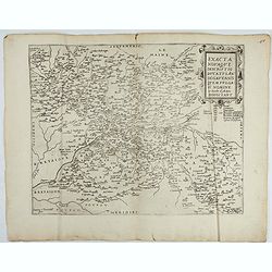
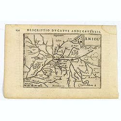
Exacta novaqve descriptio dvcatvs Andegravensis qvem vvlgari nomine Le Duche d'Aniou Indigitant.
Centered on the town of Angiers. From the first edition of De Jode's Speculum Orbis Terrarum, the second general atlas of the world, after Ortelius. Engraved by Ioannes V...
- $750 / ≈ €658
Date: Antwerp, 1578
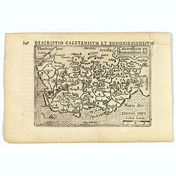
1) Caletensivm et Bononiensivm..2) Veromandvorvm eorvmque..
Prepared by Jean Surhon, cartographer, goldsmith and engraver. From 'Theatrum Orbis Terrarum [Atlas of the Whole World]': published in Antwerp.
- $200 / ≈ €176
Date: Antwerp, 1580
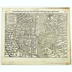
Lutetia Parisiorum urbs, toto orbe celeberrima notissimaque, caput regni Franciae.
Early bird's eye view of Paris, called at the time Lutetia. From a French text edition of S. Münster's Cosmographia, which is a short and complete summary of Renaissance...
Date: Basle, 1550-1580
![[Paris] Die Statt Paris etlicher maß figuriert und contrafehret nach jetziger Gelegenheit.](/uploads/cache/49189-250x250.jpg)
[Paris] Die Statt Paris etlicher maß figuriert und contrafehret nach jetziger Gelegenheit.
Bird's-eye view of Paris. From a German text edition of S. Münster's Cosmographia, which is a short and complete summary of Renaissance knowledge. Text in German. Under ...
Date: Basle, 1550-1580
Lutezia citta de Parigini celebratissima per tuto. . .
Very early birds-eye view of Paris. From his an Italian edition of his Cosmographia, that great compendium of Renaissance knowledge. An exciting print.Engraved by Hans Ru...
Date: Basle, 1550-1580
ARTESIA Comit.
Mercator's early map of the northern French region of Artois. Divisions in outline colors, strap-work title cartouche and mileage scale in the upper right, and lower left...
Date: Duisbourg, 1585

Beschrijvinge vande de zee Cuften va Vlanderen en Picardien. . .
DUTCH TEXT EDITION. A detailed chart of the coast of Flanders and Normandy decorated by a large colorful baroque title cartouche, and the coat of arms of Flanders with a ...
Date: Leiden, Plantijn, 1585

Beschrijvinge vande de zee Cuften va Vlanderen en Picardien. . .
A detailed description of the coast of Picardie and Normandy decorated by a large colored baroque title cartouche, and the coat of arms of Flanders with a colorful scale ...
- $1750 / ≈ €1536
Date: Amsterdam, 1585
![[Prince of Condé captured and murdered, 1569]](/uploads/cache/38547-250x250.jpg)
[Prince of Condé captured and murdered, 1569]
Early print showing the Prince of Condé captured and murdered, 1569.Plate from the series about the " Eighty Years War" or the independence war of Holland agai...
- $50 / ≈ €44
Date: Cologne, ca. 1590
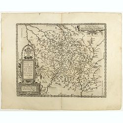
Picardiae Belgicae regionis descriptio
From Theatrum Orbis Terrarum [Atlas of the Whole World]. Prepared by Jean Surhon.Dare to go in Black. All early maps were printed in black and white, and many were kept t...
Date: Antwerp, 1590
Valencena . . .
Eye-bird view of Valenciennes.
Date: Anvers, 1590
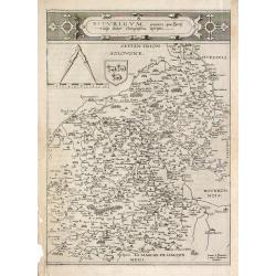
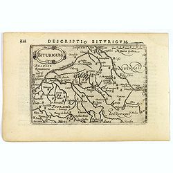
Bitvrigvm, provinciae que Berry.
A rare and beautifully engraved map from the second edition of De Jode's atlas "Speculum Orbis Terrarum". Includes the Loire Valley, centered on Bourges and Vie...
Date: Antwerp, 1593
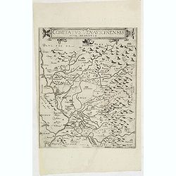
Comitatus Venayscinensis Nova Discriptio.
Rare map depicting part of Provence with Avignon, Cavaillon, Orange, Carpentras, etc.Gerard De Jode was the great rival of Ortelius, both made a living out of selling map...
- $325 / ≈ €285
Date: Antwerp, 1593

Lutetia Furens. Das ist : Die wütende Statt PARIS.
Rarissime placard dirigé contre la Ligue et le duc de Mayenne. La gravure est signée I.S. (marque inconnue). Ce placard en latin et en allemand est une reprise de l’e...
Date: France ca.. 1594
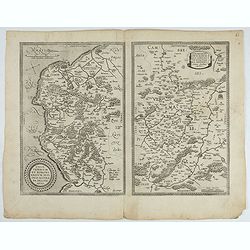
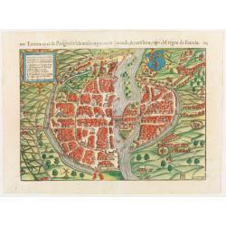
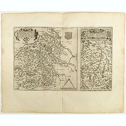
![Blaisois Blesiensis Territorii. . . [together with] - Lemovicum totius et confinium provinciarum. . .](/uploads/cache/28865-250x250.jpg)
Blaisois Blesiensis Territorii. . . [together with] - Lemovicum totius et confinium provinciarum. . .
The map on the left is centered on the Loire with the town of Blois. The right hand map is centered on Limoges.
- $150 / ≈ €132
Date: Antwerp, c. 1595

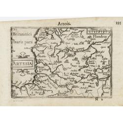
Artois. Atrebatum Regionis Vera Descripto.
Prepared by Jacob Surhon, who made a manuscript map of Artois for which he received 36 Livres from Charles V in 1554. For security reasons, the map was not published. Onl...
Date: Antwerp, 1598
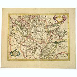
Regionis Biturigum... Per Ioannem Calamaeum. / Limaniae Topographia Gabriele Symeoneo Auct.
Two maps on one sheet. Biturigum. The Loire river is on the right in central France. Neuers (Nevers) is at the middle of the right margin. Bourges is near the center, and...
Date: Antwerp, 1598
![Blaisois Blesiensis Territorii. . . [together with] - Lemovicum totius et confinium provinciarum. . .](/uploads/cache/40963-250x250.jpg)
Blaisois Blesiensis Territorii. . . [together with] - Lemovicum totius et confinium provinciarum. . .
The map on the left is centered on the Loire with the town of Blois. The right-hand map is centered on Limoges. Dare to go in Black. All early maps were printed in bla...
Date: Antwerp, 1598
Anjou. Andegavensium Ditionis Vera et Integra Descriptio. Licimo Guijeto Andegavense auctore.
Beautiful map of the Anjou region of western France along the Loire River. Include the city of Angers in the center. Accompanying French text on verso. Dare to go in B...
Date: Antwerp, 1598
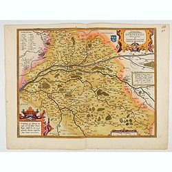
Touraine. Turonensis Ducatus.
Map of Touraine Duché in very fine original colours.
Date: Antwerp, 1598

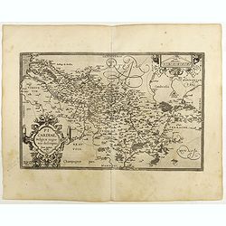
Regionis Biturigum... Per Ioannem Calamaeum. / Limaniae Topographia Gabriele Symeoneo Auct.
Two maps on one sheet. Biturigum. The Loire river is at the right in central France. Neuers (Nevers) is at the middle of the right margin. Bourges is near the center, an...
- $125 / ≈ €110
Date: Antwerp, ca. 1598
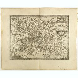
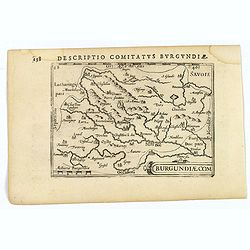
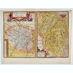
Burgundiae inferioris quae Ducatus Nomine Censetur, Des.
Map centered on the province of Burgundy, from 'Theatrum Orbis Terrarum'.Dare to go in Black. All early maps were printed in black and white; many were kept that way for ...
- $100 / ≈ €88
Date: Antwerp, 1598
![Le Roy de Navarra venant à Paris recheut le coup de cousteau au visaige par ung Pierre Chastel, lequel par quatre chevaulx fut tiré en pièces, faict le 27 de Decemb[re] l'an 1594.](/uploads/cache/38548-250x250.jpg)
Le Roy de Navarra venant à Paris recheut le coup de cousteau au visaige par ung Pierre Chastel, lequel par quatre chevaulx fut tiré en pièces, faict le 27 de Decemb[re] l'an 1594.
Engraved news-sheet with text in German and French. Pictorial reportage on the failed assassination attempt on King Henri IV of France by Jean Châtel (here identified as...
Date: Cologne, ca. 1600
Aniou.
Anjou is a historical province of France, straddling the lower Loire River. Its capital was Angers. It bordered Brittany to the west, Maine to the north, Touraine to the ...
Date: Amsterdam, 1606
Caletensium et Bononiesium def.
An decorative miniature map of the N.W. France, including Calais and Boulogne. A map full of detail and attractive embelishments. North is orientated to the left. From th...
- $100 / ≈ €88
Date: Amsterdam, 1606
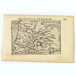
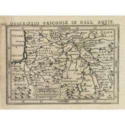
Gasconia.
A lovely miniature map of Gascony, in the S.W. region of France, published by Petrus Bertius, in Amsterdam at the beginning of the seventeenth century. There is a small s...
Date: Amsterdam, 1606
![Descriptio Gadium [France].](/uploads/cache/43237-250x250.jpg)
Descriptio Gadium [France].
An attractive miniature map of France, published by Petrus Bertius, in Amsterdam at the beginning of the seventeenth century. Title in bold capital letters above map, sti...
Date: Amsterdam, 1606
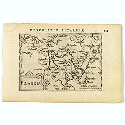
Picardia.
A decorative miniature map of Picardy, a historical northern French region. A map that appears to be sparsely populated is still full of detail with great attention to de...
Date: Amsterdam, 1606
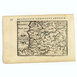
Artesia.
A decorative miniature map of Artois, a historical northern French province that borders Belgium. A map full of detail and is expertly engraved. With the cities of Boulo...
Date: Amsterdam, 1606
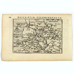
Descriptio Veromanduorum.
A decorative miniature map of Aisne (Vermandois), a French department in the Hauts-de-France region of northern France. It is named after the river Aisne. The map is cent...
Date: Amsterdam, 1606
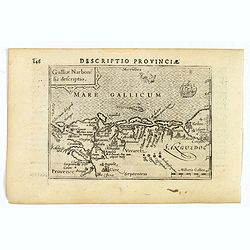
Descriptio Provinciae.
A decorative miniature map of Provence - a geographical region and historical province of south-eastern France, which extends from the left bank of the lower Rhône River...
Date: Amsterdam, 1606
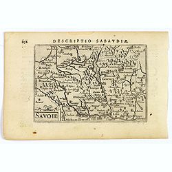
Savoie.
A decorative miniature map of Savoy - a cultural region in Central Europe that comprises roughly the territory of the Western Alps between Lake Geneva in the north and Da...
Date: Amsterdam, 1606
![Venuxinus Comitatus. [Vaucluse]](/uploads/cache/43427-250x250.jpg)
Venuxinus Comitatus. [Vaucluse]
A pleasant miniature map of the Vaucluse region of S.E. France, as published by Petrus Bertius in Amsterdam at the beginning of the seventeenth century. Many mountains as...
Date: Amsterdam, 1606
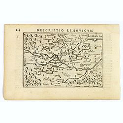
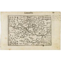
Limania.
A pleasant miniature map of the Limousin region of central France, the area surrounding Clermont Ferrand. Good map detail. From the Bertius atlas Tabularum geographicarum...
Date: Amsterdam, 1606
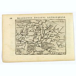
Lotharingia.
Lothringaria (Lorraine) is a historical province of N.E. France, it features the cities of Sarrebourg, Metz, Toul and Nancy. With excellent physical and topographical det...
- $100 / ≈ €88
Date: Amsterdam, 1606
Descriptio Biturigum.
A charming small map of central France. Showing the areas around the rivers Loire, Auron, Allier and Yevre. Nevers and Bourges depicted. From the Bertius atlas Tabularum ...
- $100 / ≈ €88
Date: Amsterdam, 1606
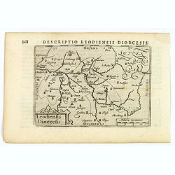
Descriptio Leodiensis Dioecesis.
A decorative map of the ancient Diocese of liege in Belgium, highlighting cities such as Huy, Liege, Tongeren (old capital), Namur and Maastricht. North is orientated to ...
- $100 / ≈ €88
Date: Amsterdam, 1606
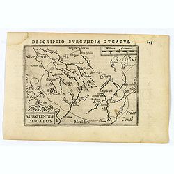
Descriptio Burgundiae Ducatus.
A decorative small map of region around Dijon, Chalons and Dole in Burgundy. Shows many rivers including the Seine, Saone and Brune. It features a nice strap-work title, ...
Date: Amsterdam, 1606
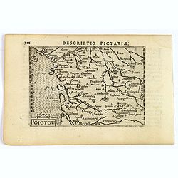
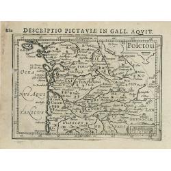
Descriptio Pictaviae.
A charming small map of Poitou in west central France. Showing Cognac, Limoges, Perigord, Poitiers and Angouleme. From the Bertius atlas Tabularum geographicarum contract...
Date: Amsterdam, 1606
Descriptio Comitatus Burgundiae.
A decorative small map of region around Dijon, Halons and Dole in Burgundy. Features a nice strap-work title, shows rivers and settlements. From the Bertius atlas Tabular...
Date: Amsterdam, 1606
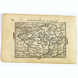
Descriptio Galliae.
A charming small map of ancient Gaul, France under Roman occupation. Featuring most major cities, rivers, mountains and regions are named. From the Bertius atlas Tabularu...
Date: Amsterdam, 1606
Totius Lemovici et . . .
Map of part of France, centered on Limoge, including a plan of Limoge. Prepared by Jean du Fayen (1530-1612), French physician and geographer, who prepared the first know...
Date: Amsterdam, 1608

Biturigum.
A miniature map of the Berry. Fine cartouche in the upper left corner.First published in 1598 in his Caert-Thresoor, the plates were executed by the most famous engravers...
Date: Amsterdam/Frankfurt 1609
Limania / Limousin.
A miniature map of the Limousin. Fine cartouche in the upper right corner.First published in 1598 in his Caert-Thresoor, the plates were executed by the most famous engra...
Date: Amsterdam / Frankfurt, 1609
Artesia / Artois.
A miniature map including northern part of France. Title cartouche on the left side.First published in 1598 in his Caert-Thresoor, the plates were executed by the most fa...
Date: Amsterdam/Frankfurt 1609
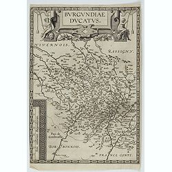
Burgundiae Ducatus. Burgundiae Comitatus.
Separately issued map of Burgundy area. Two maps of Burgundy region on a plate. Separately published map, without text on the verso. Second state with the date 1597 remov...
Date: Antwerp, after 1612
Burgundiae Ducatus.
Map of Burgundy region without text on the verso. Second state with the date 1597 removed from the title cartouche. This is the rarest Burgundy map of the four that Ortel...
- $500 / ≈ €439
Date: Antwerp, after 1612
Artois. Atrebatum Regionis Vera Descripto.
Prepared by Jacob Surhon who made a manuscript map of Artois for which he received 36 Livres from Charles V in 1554. For security reasons the map was not published. Only ...
- $500 / ≈ €439
Date: Antwerp, after 1612
Provinciae, Regionis Galliae, vera exactissimaq. descriptio. Provence Petro Ioanne Bomparioo auctore.
A finely engraved map of the Province prepared by Pierre-Jean de Bompar who published a single sheet map of the Province in 1591. Title cartouche in the upper left-hand c...
- $500 / ≈ €439
Date: Amsterdam, 1613
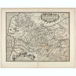
Gallia. Nova Galliae descriptio . . .
Very rare and early map of France with figures on three sides with views of cities, portraits (Henri IV and Marie de Medicis) and costumes. The map was directly influence...
Date: Amsterdam, 1616
Poictou.
Text in Latin on verso.
Date: Amsterdam, 1616-1618
Guascogne.
Text in Latin on verso.
Date: Amsterdam, 1616-1618
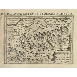
Benearnia et Bigornia.
Text in Latin on verso.
Date: Amsterdam, 1616-1618
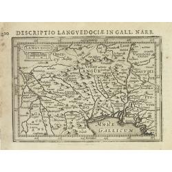
Languedoc.
Text in Latin on verso.
- $100 / ≈ €88
Date: Amsterdam, 1616-1618
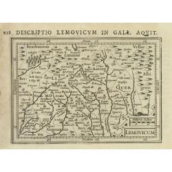
Lemovicum.
Text in Latin on verso.
- $80 / ≈ €70
Date: Amsterdam, 1616-1618
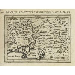
Comit. Avenionensis.
Text in Latin on verso.
- $100 / ≈ €88
Date: Amsterdam, 1616-1618
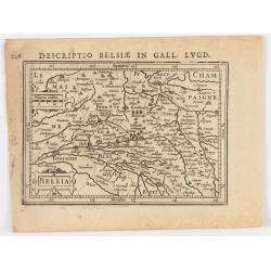
Belsia.
Text in Latin on verso.
- $80 / ≈ €70
Date: Amsterdam, 1616-1618
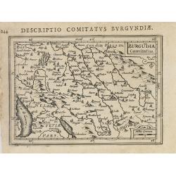
Burgundia Comitatus
Text in Latin on verso.
- $80 / ≈ €70
Date: Amsterdam, 1616-1618
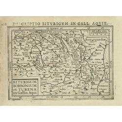
Biturigum borbonium et Turena in Gallia Aqui.
Text in Latin on verso.
- $80 / ≈ €70
Date: Amsterdam, 1616-1618
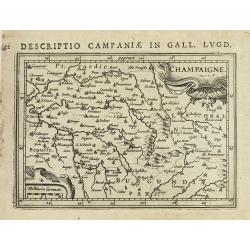
Champaigne.
Text in Latin on verso.
Date: Amsterdam, 1616-1618
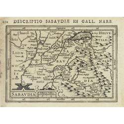
Sabaudia.
Text in Latin on verso.
- $100 / ≈ €88
Date: Amsterdam, 1616-1618
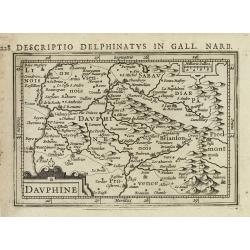
Dauphiné.
Text in Latin on verso.
- $80 / ≈ €70
Date: Amsterdam, 1616-1618
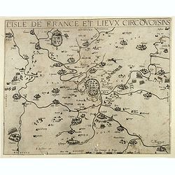
L'Isle de France / Parisiensis agri descrip.
Adorned with a title cartouche and a framing border. Leclerc's "Theatre geographique de France" is an extension of Bouguereau's "Theatre". A refugee w...
Date: Paris, ca. 1619
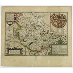
![[Lot of 17 maps] L' ISLE DE FRANCE Pariensis agri descriptio. Francois de la Hoeye fecit, Jean le Clerc excud.](/uploads/cache/19592-250x250.jpg)
[Lot of 17 maps] L' ISLE DE FRANCE Pariensis agri descriptio. Francois de la Hoeye fecit, Jean le Clerc excud.
The map of Ile de France which Jean Leclerc added in his re-issue of Maurice Bouguereau's atlas 'Theatre Francois' , as ' La Theatre geographique de France' in 1619. An u...
- $1000 / ≈ €878
Date: Paris, 1619
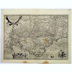
Provinciae, Regionis galliae, vera exactissimaq. Descriptio
This is a highly detailed and well engraved map of Provence in southern France. Engraved by H.Picart and published by Jean le Clerc.Jean le Clerc (1560-1621) was an engra...
- $500 / ≈ €439
Date: Paris, ca. 1620
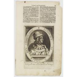
Lodovicus XIII. D. G. Galliae Et Navarrae Rex Christianiss.
The engraving depicts a half length oval portrait of Louis XIII of France.Nicolaes de Clerck (de Klerc) was active as engraver and publisher in Delft from 1599-1621.Inclu...
- $25 / ≈ €22
Date: Amsterdam, Cloppenburch, 1621
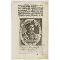
Franciscus I. D. G. Galliarum Rex Christianissimus.
The engraving depicts a half length oval portrait of Francis I of France.Nicolaes de Clerck (de Klerc) was active as engraver and publisher in Delft from 1599-1621.Includ...
Date: Amsterdam, Cloppenburch, 1621
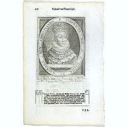
Ludovius XI. D. G. Galliae Rex Christianiss.
The engraving depicts a half length oval portrait of Louis XI of France.Nicolaes de Clerck (de Klerc) was active as engraver and publisher in Delft from 1599-1621.Include...
Date: Amsterdam, Cloppenburch, 1621
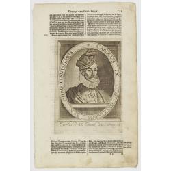
Carolus IX. D. G. Galliarum Rex Christianissimus.
The engraving depicts a half length oval portrait of Charles IX of France.Nicolaes de Clerck (de Klerc) was active as engraver and publisher in Delft from 1599-1621.Inclu...
Date: Amsterdam, Cloppenburch, 1621
Gallia.
Small map of France, surrounded by text in Dutch. Nicolaes de Clerck (de Klerc) was active as engraver and publisher in Delft from 1599-1621.Included in the rare book : W...
- $70 / ≈ €61
Date: Amsterdam, Cloppenburch, 1621
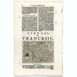
Lotaringia Ducatus.
Small map of Lorraine, oriented with West on top and surrounded by text in Dutch. Nicolaes de Clerck (de Klerc) was active as an engraver and publisher in Delft from 1599...
- $75 / ≈ €66
Date: Amsterdam, Cloppenburch, 1621
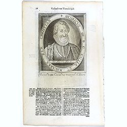
Henricus IIII. D. G. Galliae Et Navarrae Rex Christian.
The engraving depicts a half length oval portrait of Henry IV (1553 – 1610), also known by the epithet "Good King Henry", was King of Navarre (as Henry III) f...
- $25 / ≈ €22
Date: Amsterdam, Cloppenburch, 1621
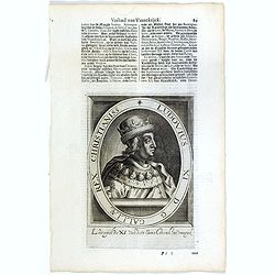
Ludovius XI. D. G. Galliae Rex Christianiss.
The engraving depicts a half length oval portrait of Louis XI of France.Nicolaes de Clerck (de Klerc) was active as engraver and publisher in Delft from 1599-1621.Include...
- $25 / ≈ €22
Date: Amsterdam, Cloppenburch, 1621
