
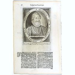
Carolus V D. G. Romanor Imperator Semper August.
The engraving depicts a half length oval portrait of Charles V (24 February 1500 – 21 September 1558) was ruler of both the Spanish Empire from 1516 and the Holy Roman ...
- $25 / ≈ €22
Date: Amsterdam, Cloppenburch, 1621
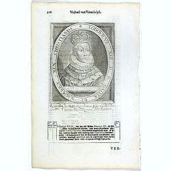
Lodovicus XIII. D. G. Galliae Et Navarrae Rex Christianiss.
The engraving depicts a half length oval portrait of Louis XIII of France.Nicolaes de Clerck (de Klerc) was active as engraver and publisher in Delft from 1599-1621.Inclu...
- $25 / ≈ €22
Date: Amsterdam, Cloppenburch, 1621
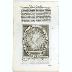
Maria De Medices D. G Galliae et Navarrae Reg. Uxor Henr. IIII.
The engraving depicts a half length oval portrait of Marie de' Medici, queen consort of France .Nicolaes de Clerck (de Klerc) was active as engraver and publisher in Delf...
- $15 / ≈ €13
Date: Amsterdam, Cloppenburch, 1621
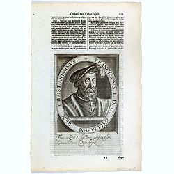
Franciscus I. D. G. Galliarum Rex Christianissimus.
The engraving depicts a half length oval portrait of Francis I (François Ier) (1494 – 1547) was the first King of France from the Angoulême branch of the House of Val...
- $25 / ≈ €22
Date: Amsterdam, Cloppenburch, 1621
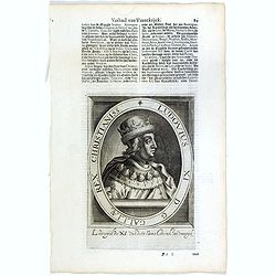
Ludovius XI. D. G. Galliae Rex Christianiss.
The engraving depicts a half length oval portrait of Louis XI of France.Nicolaes de Clerck (de Klerc) was active as engraver and publisher in Delft from 1599-1621.Include...
- $25 / ≈ €22
Date: Amsterdam, Cloppenburch, 1621
Henricus IIII. D. G. Galliae Et Navarrae Rex Christian.
The engraving depicts a half length oval portrait of Henry IV (1553 – 1610), also known by the epithet "Good King Henry", was King of Navarre (as Henry III) f...
- $25 / ≈ €22
Date: Amsterdam, Cloppenburch, 1621
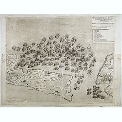
Le grand combat ov Monsieur de Montmorancy admiral de Fance . . .
Attractive view of the naval Battle of Saint-Martin de Ré, fought on 15 September 1625 between the Huguenot fleet of La Rochelle, commanded by Admiral Jean Guiton- Admir...
Date: Paris, 1625

Carte de la Coste de La Rochelle a Brouaige et de l'Isle d'Oleron Observee par le S.r de Chattillon ingenieur du Roy.
Map of the island of Oléron, with an inset in lower left corner showing the route of an English fleet to La Rochelle. At the time of mapping the area was a stronghold of...
Date: Paris, 1627
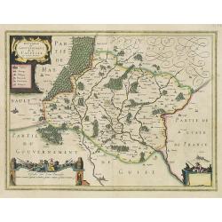
Champagne Comitatus Campania.
Map of French region of Champagne, including part of Lorraine. North to the east. The second state with the signature of J.Janssonius.
- $220 / ≈ €193
Date: Amsterdam, 1630
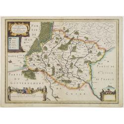
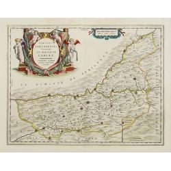
Description du Gouvernement de la CAPPELLE. Par P. Petit Bourbon.
RARE without text on verso. Decorative map of Cappellein the region of the Nord-Pas-de-Calais in France with three decorative cartouches.The map of Cappelle is by Pierre ...
- $150 / ≈ €132
Date: Amsterdam, 1631
Description du Gouvernement de la CAPPELLE. Par P. Petit Bourbon.
Decorative map of Cappellein the region of the Nord-Pas-de-Calais in France with three decorative cartouches.The map of Cappelle is by Pierre Petit Bourbon (1598-1667), m...
- $100 / ≈ €88
Date: Amsterdam, 1631
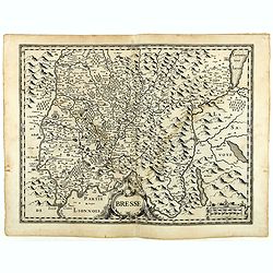
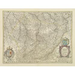
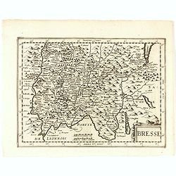
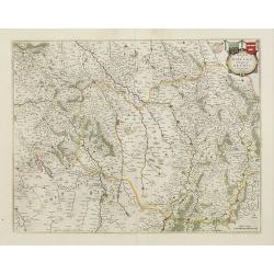
Bresse.
Early map of Eastern France with Lyon to the lower left corner and part of Switzerland. Geneva in upper right corner. Engraved by Hondius. From a French composite atlas.R...
- $150 / ≈ €132
Date: Amsterdam, 1631
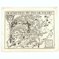
Description du pais de Valois.
Rare map published by Jean Le Clerc (1560-1621) and prepared by Damien de Templeux map of the region to the northeast of Paris, between the Oise River in the west and the...
- $300 / ≈ €263
Date: Paris, 1632
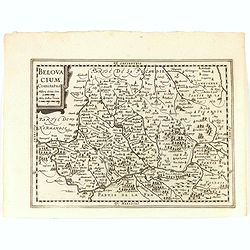
Belovacium comitatus.
Early map centered north of Paris. With Latin text on verso. Engraved by Petrus Kaerius. Shortly after the publication of big folio-atlases the need was apparently felt f...
- $75 / ≈ €66
Date: Amsterdam, 1632
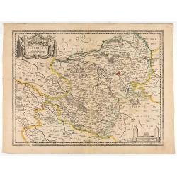
Bresse.
Early map of Eastern France and part of Switzerland. Geneva in upper right corner. With Latin text on verso. Engraved by Petrus Kaerius. Shortly after the publication of ...
- $50 / ≈ €44
Date: Amsterdam, 1632
![[John Smith caught by the French.]](/uploads/cache/40473-250x250.jpg)
[John Smith caught by the French.]
In 1615, during one of John Smith’s voyages across the Atlantic, he was caught by some French pirates. While at sea in captivity he was forced to suffer great hardships...
- $75 / ≈ €66
Date: Frankfurt, M.Merian, 1633
![[John Smith caught by the French].](/uploads/cache/41114-250x250.jpg)
[John Smith caught by the French].
In 1615, during one of John Smith’s voyages across the Atlantic, he was caught by some French pirates. While at sea in captivity he was forced to suffer great hardships...
Date: Frankfurt, M.Merian, 1633
St Tropez.
Published by Nicolas Tassin in "Les Plans et Profilz de toutes principalles Villes et lieux considerable de France." The first edition of this work was publish...
- $100 / ≈ €88
Date: Paris, Sébastien Cramoisy, 1636

Loudunois. Laudunum / Mirebalais.
Two maps on one sheet. Centered on Loudun and Mirebeau. Showing lower left cartouche putti playing with grapes.German text on verso.
Date: Amsterdam, after 1636

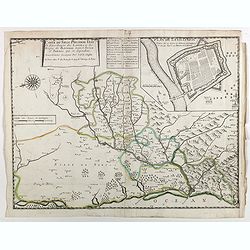
Carte du Siège Présidial Dax... Nouvellement Deseignee Par le...
Very rare map including Bayonne and Dax in the southwest of France. With inset plan of "Plan de la ville Dax.". With the address "Chez F. Dela Pointe sur l...
Date: Paris, 1638
Carte du siège présidial Dax et seneschaucee des Lannes et des sieges de Bayonne sainct sever et Tartas qui en dependent Nouvellement dessignee Par le Sr de Classun.
Very rare map including Bayonne and Dax in the south west of France. With inset plan of "Plan de la ville Dax.". Engraved by Henri le Roy. With the address &quo...
Date: Paris, 1638
Bituricum Ducatus. Duche de Berri.
A very decorative map with beautiful cartouches of a province of France by one of the most famous map publishers. Berry is a region located in the center of France. It wa...
Date: Amsterdam, 1640
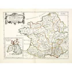
Antiquorum Galliae episcopatuum geographica descriptio. . . / Antiqui magnae Britaniae Episcopatus.
Detailed map of France during Ancient times. In lower left corner inset map of England "Antiqui magnae Britaniae Episcopatus." (160x146mm.) First published in &...
Date: Paris, ca.1641
Belsia vulgo La Beausse.
In the left-hand lower part of the image a beautiful contemporary cartouche with goddess Ceres [agricultural] holding a reaping-hook in her right hand and receiving with ...
- $200 / ≈ €176
Date: Amsterdam , 1644
Les Souverainetez de Sedan et de Raucourt.. Doncheri.
A very decorative map with beautiful large cartouches of a province of France by one of the most famous map publishers. From early on Willem Jansz. Blaeu aimed of publis...
- $175 / ≈ €154
Date: Amsterdam, 1644
Territorium Metense. Auctore Ab. Fabert.. Le Pais Messin.
A very decorative map of part of Lorraine with beautiful cartouches. Orientated with West on top. Centered on Metz. From early on Willem Jansz. Blaeu aimed of publishing...
- $300 / ≈ €263
Date: Amsterdam, 1644
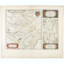
Lemovicum.. Lymosin. / Topographia Limaniae. . .
Two maps on one sheet. The author of the map of Lymosin was the French physician and cartographer Jean du Fayen. From early on Willem Jansz. Blaeu aimed of publishing an...
- $175 / ≈ €154
Date: Amsterdam, 1644
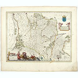
Xaintonge et Angoumois.
This map features a portion of western coastal France, north of Bordeaux with Ile de Ré and Ile Oléron. Two large cartouches show cherubs with grapes and wheat, and tw...
- $450 / ≈ €395
Date: Amsterdam, 1644
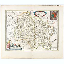
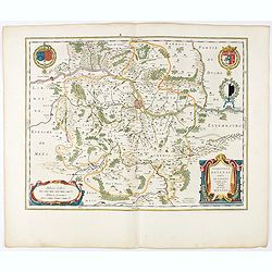
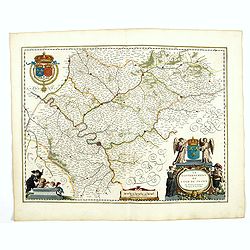
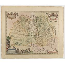
Cadurcium Vernaculé Querci.
Detailed map of a province of France by one of the most famous map publisher. Centered on Cahors.In the lower-left corner, a colored scale cartouche surmounted by a monke...
Date: Amsterdam, 1644
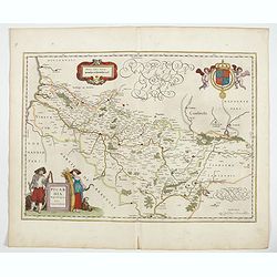
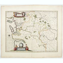
Picardia Regio Belgica.
Map of the northern region of Picardy. The region is well known due to the 4 major battles fought between France, Britain and Germany between 1915-18 during World War I. ...
- $400 / ≈ €351
Date: Amsterdam, 1644
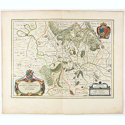
Veromanduorum.. Vermandois / Gouvernement de la Capelle.
A very decorative map with beautiful cartouches of a province of France by one of the most famous map publishers. Signed by Guilielmus Blaeu.From early on Willem Jansz. B...
- $220 / ≈ €193
Date: Amsterdam, 1644
Le Gouvernement de l'Isle de France.
A very detailed map of Ile de France centered on Paris. Showing Beauvais, Compiègne, Noyon, Laon, Soisson, Vernon, Mante, Pontoise, Meaux, etc.Adorned with the royal arm...
- $300 / ≈ €263
Date: Amsterdam, 1644
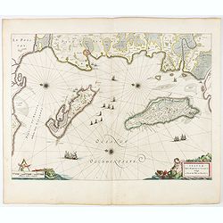
Insulae Divi Martini et Uliarus, vulgo L'Isle de Ré.. Oleron.
Map of Ré and Oléron islands. Depicting the west coast of France, showing La Rochelle. Several vessels and sailing ships dot the Atlantic ocean.Three windroses indicate...
- $950 / ≈ €834
Date: Amsterdam, 1644
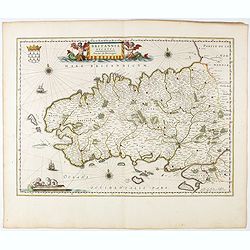
Britannia Ducatus. Duché de Bretaigne.
Map of Bretagne in France. From early on Willem Jansz. Blaeu aimed of publishing an atlas to compete with the Hondius-Jansson Atlas. By 1630, he had published at least 1...
- $650 / ≈ €570
Date: Amsterdam, 1644
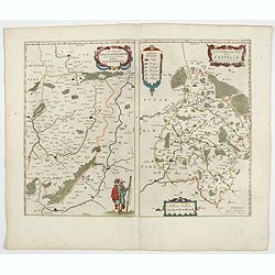
![Perchensis Comitatus [together with] Comitatus Blesensis.](/uploads/cache/44784-250x250.jpg)
Perchensis Comitatus [together with] Comitatus Blesensis.
Two maps on one sheet, each with its own decorative title cartouche. These maps detail the region of the Loire River. Perchensis includes the cities of Mortagne, Nogent-l...
Date: Amsterdam , ca 1645
La ville archie-piscopale et primatiale de Vienne en Dauphiné.
View of Vienne, engraved by François de La Pointe.
- $600 / ≈ €527
Date: Paris, 1648
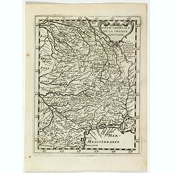
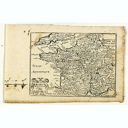
La partie orientale de la Grande Aquitaine.
Map taken from "Geographique Theater de l'Europe …, a rare work by the Jesuit priest Briet.
Date: Paris, 1649
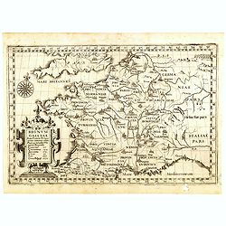
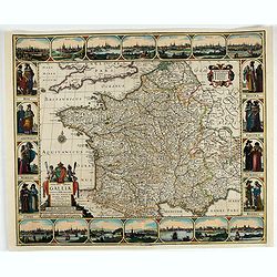
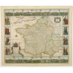
Regnum Galliae. . .
Map of France from the rare atlas of the Capucin order: "Chorographica descriptio provinciarum, et conventum fratrum minorum S. Francisci Capucinorum…".
Date: Turin, 1649
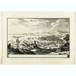
Massilia - Marseille.
Detailed bird's-eye view of the town of Marseille. From Merian's Theatrum Europaeum. To the bottom a lettered key to the principal places in town.
Date: Frankfurt 1650

Le Duché d'Aiguillon Tracé Par le Sr. Du Vall.
Home of the "Cahors” This AOC is the most famous of the sub-regions and home to the popular variety Malbec. These inky wines have been adored for centuries, especi...
Date: Amsterdam, 1650
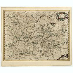
Aniou. . .
Decorative map centered on the Loire valley. Fine title cartouche in upper right corner.
Date: Amsterdam, 1650
Gouvernement General de l'Ile de France. . .
Fine map of Isle de France, centered on ParisThis edition carries the date 1651. Engraved by Jean Sommer.Nicolas Sanson was to bring about the rise of French cartography,...
- $200 / ≈ €176
Date: Paris, 1651
Nova Haec tabula Galliae. . .
Dated 1653. This handsome map of France is dedicated to Louis XIV, interesting in light of the nearly constant warfare between Louis and the Netherlands in the ensuing ye...
Date: Amsterdam, 1653
L'evesché d'Aire. . .
In center Adour (river), Aire-sur-l'Adour, with Aire and Dax in lower right corner. Janssonius does give credit to Pierre du Val. In lower left corner putti with grapes.D...
- $300 / ≈ €263
Date: Amsterdam, 1656
Dicecese de Rheims, et le païs de Rethel. . .
Centered on Rheims. A very decorative map with beautiful cartouches of a province of France by one of the most famous map publishers.
- $300 / ≈ €263
Date: Amsterdam, 1658
Dioecesis Sarlatensis, Vernacule.. Sarlat.
Detailed map of the region south of the Dordogne River, depicting Bergerac, Saint Cyprien, Montignac, Sarlat, Villefranche, etc.Embellished with an impressive title carto...
- $200 / ≈ €176
Date: Amsterdam, 1658
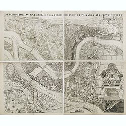
Description au naturel de la ville de Lyon et païsages alentour d'icelle.
PREMIERE EDITION. Plan de Lyon à « vol d’oiseau » commandé par le consulat, destiné à la diffusion et à la notoriété de la cité, mariant ainsi image de la vil...
Date: Lyon, 1659
Flandria Gallica Continens Castellanias Insulense . . .
No text on verso. Map of northern part of France, centered on Lille and part of Belgium.
Date: Amsterdam, c. 1660
Nova Haec tabula Galliae. . .
Dated 1660. This handsome map of France is dedicated to Louis XIV, interesting in light of the nearly constant warfare between Louis and the Netherlands in the ensuing ye...
Date: Amsterdam, 1660
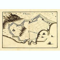
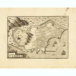
St Tropez.
Plan of St Tropez by M.Merian. Depicts a street layout and ships in harbour etc.
- $130 / ≈ €114
Date: Frakfurt, 1660
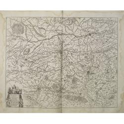
Champaigne et Brie etc.
A good engraved map of Champagne-Ardenne area, embellished with decorative title cartouche and scale cartouche with putti and surveying instruments. Paris, Metz, Reims, a...
- $150 / ≈ €132
Date: Paris, ca. 1660
France nouvellement descripte.
Rare map of France, published by Jollain in 1667. Published in "Trésor Des Cartes Geographiques Des Principaux Estats de Lunivers".This atlas is based upon Boi...
- $150 / ≈ €132
Date: Paris, 1667

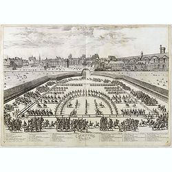
Course de Baque et Disposition des Quadrilles, dans l'Amphiteatre seconde journée.
An early and intriguing engraving recording one of the most celebrated and spectacular festivals held at Paris by the young Louis XIV. The multi-day tournament took place...
Date: Paris, imprimerie royale, 1670
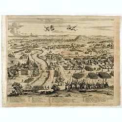
Comparse des Cinq Quadrilles dans l'Amphitheatre.
An early and intriguing engraving recording one of the most celebrated and spectacular festivals held at Paris by the young Louis XIV. The multi-day tournament took place...
Date: Paris, imprimerie royale, 1670
The siege of Lagny.
Very rare etching of the siege of Lagny-sur-Marne by the Duc of Parma. Etched by Johann Azelt (1654-1692). A similar print but with the number in the upper right corner i...
- $150 / ≈ €132
Date: Nuremberg, ca 1675

Paris, Lutetia, Parisii, Ville Capitale du Royaume de France.
View of Paris seen from the hill "Belleville based on that of Merian (1616) but updated with the new gates Saint-Denis and Saint-Martin. With a key 1-78 and A-Z. Sur...
Date: Paris, after 1676
![S. Laurens in Franckr. [France].](/uploads/cache/13810-250x250.jpg)
S. Laurens in Franckr. [France].
A very nice view of the town of Saint Laurens in Alsace, with a church. On the foreground, an elephant and a rhinoceros are depicted. With a verse in two languages undern...
- $40 / ≈ €35
Date: Frankfurt, 1623-1678
Vincennes - Viel hund Feind.des Hasen Todt.
A very nice picture representing Vincennes. With a verse in German and Latin. The German text reads : "Viel Hundt feind ja des Hasen Todr, Ihr viel bringn einen bald...
- $70 / ≈ €61
Date: Frankfurt, 1623-1678
![S. Victor in Franckr. [Paris].](/uploads/cache/13781-250x250.jpg)
S. Victor in Franckr. [Paris].
A very nice view of St. Victor church in Paris. In the foreground, a night watchman is depicted. With a verse in Latin and German underneath the picture. The German text ...
- $60 / ≈ €53
Date: Frankfurt, 1623-1678
S. Iulius.
A very nice view of the castle of Saint Julius. On the foreground, several frogs are depicted. With a verse in two languages underneath the picture.The poet and topograph...
- $60 / ≈ €53
Date: Frankfurt, 1623-1678
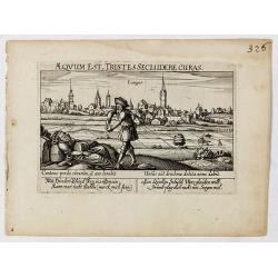
Aeqvum est, tristes secludere curas (Lianges.)
A very nice view of the city Lianges. With a verse in two languages underneath the picture.The poet and topographer from Comothau, Daniel Meisner (1585-1625), started his...
- $60 / ≈ €53
Date: Frankfurt, 1623-1678
![S. Victor in Franckr. [France].](/uploads/cache/13770-250x250.jpg)
S. Victor in Franckr. [France].
A very nice view of the church. On the foreground, a night watchman is depicted. With a verse in two languages underneath the picture.The poet and topographer from Comoth...
- $40 / ≈ €35
Date: Frankfurt, 1623-1678
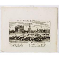
In einem Todt wollen alle zu Ritter werden.
A very nice view of a dead lion, surrounded by rabbits and in the background a French castle. With a verse in two languages underneath the picture. "In einem Todt, n...
- $70 / ≈ €61
Date: Frankfurt, 1623-1678
![In einem Todt. . . [ Chateau Chenonceaux ]](/uploads/cache/13817-250x250.jpg)
In einem Todt. . . [ Chateau Chenonceaux ]
A very nice depiction of Chateau Chenonceaux near Tours, France within the foreground is a dead lion, surrounded by rabbits. With a verse in two languages underneath the ...
- $50 / ≈ €44
Date: Frankfurt, 1623-1678
![Cordelirs in Franckr. [France].](/uploads/cache/13799-250x250.jpg)
Cordelirs in Franckr. [France].
A very nice view of the town of Cordeliers. On the foreground, a man hunting a wolf is depicted. With a verse in German and Latin underneath the picture.The poet and topo...
- $80 / ≈ €70
Date: Frankfurt, 1623-1678
![Cordelirs in Franckr. [France].](/uploads/cache/13736-250x250.jpg)
Cordelirs in Franckr. [France].
A very nice view of a monastery. With a verse in two languages underneath the picture.The poet and topographer from Comothau, Daniel Meisner (1585-1625), started his firs...
- $40 / ≈ €35
Date: Frankfurt, 1623-1678
![S. Victor in Franckr. [The Abbey of St. Victor near Paris.].](/uploads/cache/13769-250x250.jpg)
S. Victor in Franckr. [The Abbey of St. Victor near Paris.].
A very nice view of the Abbey of St. Victor near Paris. On the foreground, a night watchman is depicted. With a verse in two languages underneath the picture.The poet Dan...
- $60 / ≈ €53
Date: Frankfurt, 1623-1678
![Cordelirs in Franckr. [France].](/uploads/cache/13811-250x250.jpg)
Cordelirs in Franckr. [France].
A panoramic view of the town of Cordelirs (probably imaginary) with in center the church. On the foreground a man hunting a wolve. With a verse in two languages underneat...
- $35 / ≈ €31
Date: Frankfurt 1623-1678
![Cordelirs in Franckr. [France].](/uploads/cache/13812-250x250.jpg)
Cordelirs in Franckr. [France].
A panoramic view of the town of Cordeliers (probably imaginary) with in the center the church. In the foreground a man hunting a wolf. With a verse in two languages under...
- $50 / ≈ €44
Date: Frankfurt 1623-1678

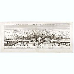
Veue de la Ville, et du Port de Calais, di côte de la terre.
Showing the town of Calais; landscape with, in the left foreground, group of cavalrymen led by an officer and going to right, at right two soldiers walking alongside a ca...
Date: Paris, ca. 1680
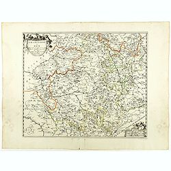
Gouvernement General de Languedoc. Divise en ses Vint Deux Diocesez.
A lovely late seventeenth century map of the central south French region of Languedoc, part of which borders the Mediterranean Sea by Dutch publisher and cartographer, Fr...
- $250 / ≈ €219
Date: Amsterdam, ca 1680

The Sea Coast of France from Ushent to Olone.
Chart showing the Brittany coast from Ushent to Ollone, with Belle-Ile. In insets : Rade de Brest and Mouth of the Loire between St. Nazaire and Nantes.Originally engrave...
Date: London, ca. 1680

The Sea Coasts of France from Olone to Cape Machicaca in Biscay . . .
Detailed chart of Biscay Bay, showing the Coast of Brittany. The chart is oriented with north-east at the top and includes two large insets of the Loire River with Nantes...
Date: London, ca. 1680
Veue de la ville, et fauxbourg de Salins…
Showing the town of Salins, a commune with salt works (Salines) in the Jura department in the region of Bourgogne-Franche-Comté in eastern France. With a key (1-15) in ...
- $700 / ≈ €614
Date: Paris, ca. 1680
![Abbaye d'Hautecombe. [Hautecombe Abbey]](/uploads/cache/45509-250x250.jpg)
Abbaye d'Hautecombe. [Hautecombe Abbey]
Showing in great detail a bird's-eye view of the Hautecombe Abbey, a former Cistercian monastery, later a Benedictine monastery, in Saint-Pierre-de-Curtille near Aix-les-...
Date: Amsterdam, 1682
![Abbaye d'Hautecombe. [Hautecombe Abbey]](/uploads/cache/45512-250x250.jpg)
Abbaye d'Hautecombe. [Hautecombe Abbey]
Showing in great detail a bird's-eye view of the Hautecombe Abbey, a former Cistercian monastery, later a Benedictine monastery, in Saint-Pierre-de-Curtille near Aix-les-...
- $150 / ≈ €132
Date: Amsterdam, 1682
![Rumiliacum vulgo Rumilix. [Rumilly]](/uploads/cache/45513-250x250.jpg)
Rumiliacum vulgo Rumilix. [Rumilly]
Showing in great detail a bird's-eye view of the city of Rumilly in the Haute-Savoie, decorated with the coat of arms and a lettered key.From "Theatrum Sabaudiæ&quo...
- $150 / ≈ €132
Date: Amsterdam, 1682
![[Roi de France - King of France]](/uploads/cache/46496-250x250.jpg)
[Roi de France - King of France]
A portrait of Louis XIV King of France.French text on verso.From the original 1683 text edition of "Description d'Univers. . ." by Allain Manesson Mallet (1630-...
Date: Paris, 1683
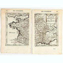
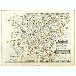
Carte generale de France.
A two-page map of France.Title in curtain draped at top. French text on verso.From the original 1683 text edition of "Description d'Univers. . ." by Allain Mane...
Date: Paris, 1683
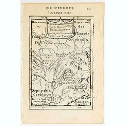
Royaume des… Royaume de Bourgogne sous la race des rois Bourguigons.
Map of Bourgogne region.Title in curtain draped at topFrom the original 1683 text edition of "Description d'Univers. . ." by Allain Manesson Mallet (1630-1706),...
Date: Paris, 1683
