Browse Listings in Europe
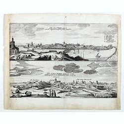
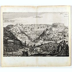
Die stadt Narva . . .
Two panoramic views of the city of Narva, on one sheet. Narva is the third largest city in Estonia. It is located at the eastern extreme point of Estonia, at the Russian...
- $250 / ≈ €212
Date: Schleßwig, Zur Glocken, 1647
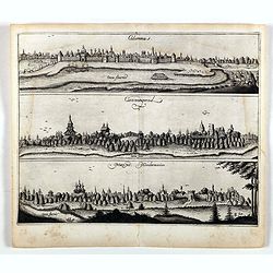
Colomna - Cassimogorod - Moruma.
Three panoramic views of Colomna - Cassimogorod - Moruma on one sheet. From the rare first edition "Offt begehrte Beschreibung der newen orientalischen Rejse, so dur...
- $300 / ≈ €255
Date: Schleßwig, Zur Glocken, 1647
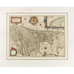
Hollandia Comitatus.
Orientated west to the top of the sheet, this presents the County of Holland in the classical orientation for seventeenth century maps, with Amsterdam at the center. The ...
Date: Amsterdam, 1647

Profil de la renomée ville et port d'Emstredam cappitalle des estats de Hollande.
Extremely rare panoramic town-view of Amsterdam seen from the river IJ.Exceptional bright, sharp example.The print is skillful copy of the print of Matthieu Merian, now w...
Date: Paris, 1647
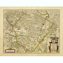
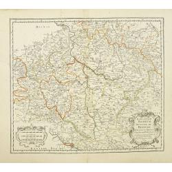
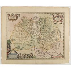
Territorium Abbatiae Herefeldensis - 't Stift Hirszfeldt.
Detailed map centered on Hirschfelt. Title cartouche embellished with two cherubs.
- $250 / ≈ €212
Date: Amsterdam, 1647
Tarku.
An early of Tarku in the Republic of Dagestan. From the rare first edition "Offt begehrte Beschreibung der newen orientalischen Rejse, so durch Gelegenheit einer Ho...
- $250 / ≈ €212
Date: Schleßwig, Zur Glocken, 1647
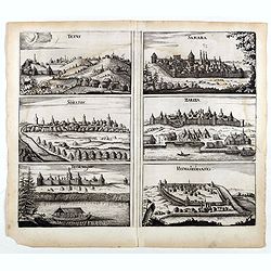
Tetus - Samara - Soratof - Zariza - Tzornogar - Kusmamedianski.
Panoramic views of Tetus, Samara, Soratof, Zariza, Tzornogar and Kusmamedianski on one sheet. From the rare first edition "Offt begehrte Beschreibung der newen orien...
- $300 / ≈ €255
Date: Schleßwig, Zur Glocken, 1647

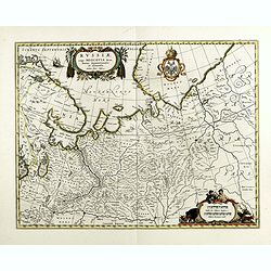
Russiae vulgo Moscovia dictae, Partes Septentrionalis et orientalis.
In the north the Murmansk Sea. Including the western coast of Nova Zembla. Title cartouche and two cartouches, the bottom right one showing two hunters, bears, stags etc....
Date: Amsterdam, 1647
Prussiae nova tabula.
Rare map of Prussia with nowadays Poland. The map features a bold title cartouche, a ship, compass rose, and a sea monster in the Baltic Sea. The map was prepared by the ...
- $550 / ≈ €467
Date: Amsterdam, 1647
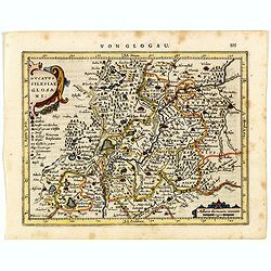
Ducatus Silesiae Glosani.
Charming map of the Silesia from the Mercator Hondius “Atlas Minor” published in Amsterdam in 1648 at Janssonius with German text on verso. Engraved by Petrus Kaerius...
- $200 / ≈ €170
Date: Amsterdam, 1648
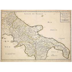
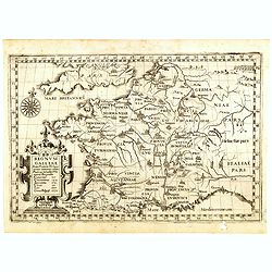
Royaume de Naples..
Fine map of the southern part of Italy.This edition carries the date 1648, engraved by AB. De la plaets. With the manuscript number in the upper right corner.Nicolas Sans...
Date: Paris, 1648
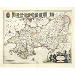
Penbrochia Comitatus et Comitatus Caermaridunum.
Attractive map of the country of Pembroke shire in UK by J. Blaeu. From a Dutch edition of "Atlas Maior" in beautiful color. With 13 coats of arms, the feathere...
Date: Amsterdam, 1648
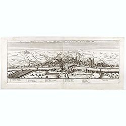
La ville archie-piscopale et primatiale de Vienne en Dauphiné.
View of Vienne, engraved by François de La Pointe.
- $600 / ≈ €510
Date: Paris, 1648

Comitatus Flandria.
A highly decorative map with in the left and right top corners the pictures of archduke Albert of Austria and Isabella, queen of Spain. In the left and right borders cost...
Date: Amsterdam, 1648

Curia Hollandiae Interior. (Binnenhof)
The government center of the Netherlands is situated in and around the Binnenhof-Buitenhof in The Hague. In 1248 the Roman king Willem II built a castle here and named it...
Date: Amsterdam, 1649

Currus Veliferi Illmi. Pr. Mauritii Nassouvii. (Prince Maurits' sailing-carriage, designed by Simon Stevin. )
Prince Maurits' sailing carriages had been designed by Simon Stevin. The Prince, always accessible to new inventions of his old instructor, could not please the foreign a...
Date: Amsterdam, 1649
![[ The repositioning of the Vatican obelisk ]](/uploads/cache/49045-250x250.jpg)
[ The repositioning of the Vatican obelisk ]
Joan Blaeu published The Repositioning of the Vatican Obelisk. This large engraving on multiple sheets and in beautiful original colors is based on Domenico Fontana’s d...
Date: Amsterdam, 1649
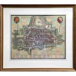
Traiectum Wttrecht
Fine plan of Utrecht from the townbooks "Novum Ac Magnum Theatrum Urbium Belgicae Liberae Ac Foederatae".FRAMED : Additional shipping costs apply. The item is l...
Date: Amsterdam, 1649
Antverpia, Gallis Anvers. Vernacule Antwerpen.
Detailed plan of the city of Antwerp with extensive key to principal buildings. Lower left title cartouche with two coats of arms and Mercurius.
Date: Amsterdam, 1649
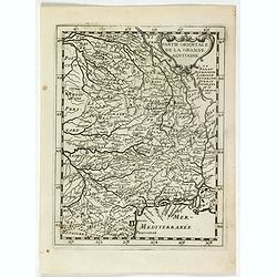
La partie orientale de la Grande Aquitaine.
Map taken from "Geographique Theater de l'Europe …, a rare work by the Jesuit priest Briet.
Date: Paris, 1649
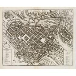
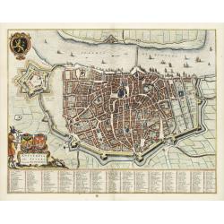
Wratislavia. Bresslaw.
Decorative town-plan of the Polish city of Wroclaw, once known as Breslau. The engraving is by the famed Swiss engraver Matthew Merian. A numbered key (1 - 38) the corner...
- $600 / ≈ €510
Date: Frankfurt, ca. 1649
Regnum Galliae. . .
Map of France from the rare atlas of the Capucin order: "Chorographica descriptio provinciarum, et conventum fratrum minorum S. Francisci Capucinorum…".
Date: Turin, 1649
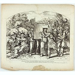
Portantes Arcam sacerdotes . . . (Plate 37)
Very nice etching by Nicolas Chapron, after Raphaël's (Raffaello Sanzio) frescoes in the Vatican Loggia. Scene illustrating Priests carrying the Ark through the River Jo...
- $25 / ≈ €21
Date: Paris, Petrus Mariette, 1649
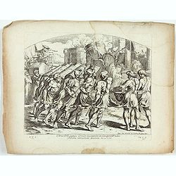
Arca Dni septies circuit Ciuitatem et clangentib tubis. Jericho corruerunt Moenia. Iosue. CVI. ( Plate 38)
Very nice etching by Nicolas Chapron, after Raphaël's (Raffaello Sanzio) frescoes in the Vatican Loggia. Scene illustrating the walls of Jericho crumbling.From the first...
- $25 / ≈ €21
Date: Paris, Petrus Mariette, 1649
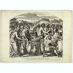
Cataractae coeli apertoe funt: Et aguae proealuerunt super terram comfumptag Est omnis caro . . . (Plate 13)
Very nice etching by Nicolas Chapron, and after Raphaël's (Raffaello Sanzio) frescoes in the Vatican Loggia. Scene illustrating the moment when God said to Noah "Go...
- $25 / ≈ €21
Date: Paris, Petrus Mariette, 1649
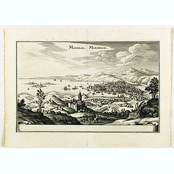
Massilia - Marseille.
Detailed bird's-eye view of the town of Marseille. From Merian's Theatrum Europaeum. To the bottom a lettered key to the principal places in town.
Date: Frankfurt 1650

Le Duché d'Aiguillon Tracé Par le Sr. Du Vall.
Home of the "Cahors” This AOC is the most famous of the sub-regions and home to the popular variety Malbec. These inky wines have been adored for centuries, especi...
Date: Amsterdam, 1650
Brabantia Ducatus.
West is at the top. On the lower left a magnificent cartouche with a sitting female figure carrying a globe and compasses and the coat of arms of Brabant. Like all other ...
- $500 / ≈ €425
Date: Amsterdam, 1650
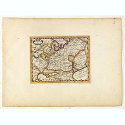
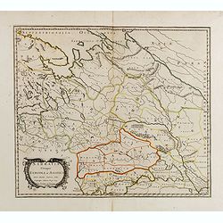
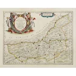
MOSCOVIAE Pars Australis. Auctore Isaaco Massa.
Very decorative map of the region north of the Sea of Azov. The map is based on the travels of Isaac Massa who visited Moscow in 1600 and thus was in the midst of the tur...
- $350 / ≈ €297
Date: Amsterdam, 1650
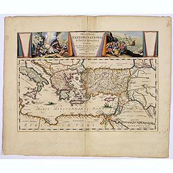
Descriptio Peregrinationis D. Pauli, Apostoli. . .
A striking map of the Mediterranean Sea and its surrounding areas. It depicts the travels of the Apostle St. Paul.The pair of decorative cartouches, presented in a curtai...
Date: Amsterdam, 1650
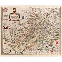
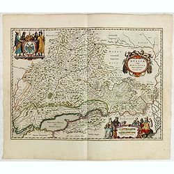
Silesia Inferior..
Decorative map prepared by Jonas Scultetus, a Silesian cartographer (1603-1664).
- $400 / ≈ €340
Date: Amsterdam, 1650
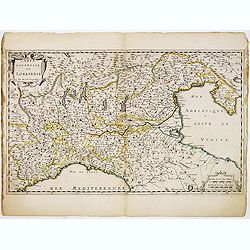
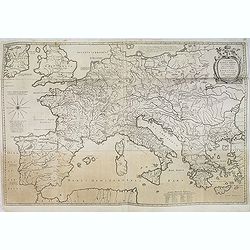
Carte Générale de Lombardie.
Fine map of Northern and middle part of Italy, engraved by A Peyrouin. According to the credit in the cartouche the map has been prepared by Pierre Duval.
Date: Paris, ca. 1650

Hassia Landgraviatus.
Centered on the town of Kassel.
Date: Amsterdam, 1650
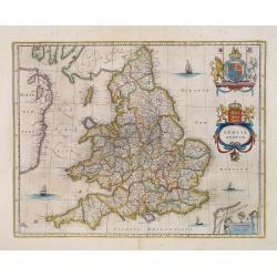
Anglia Regnum.
Willem Blaeu was the first publisher to bring out a new map of England and Wales. The outline and place names are taken from Speed with county boundaries marked but no bo...
- $500 / ≈ €425
Date: Amsterdam, 1650
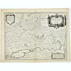
Russiae vulgo Moscovia pars australis. . .
Shows southern Russia from Crimea to 60 degrees north and from the Volga west to Smolensk. Centered on Moscow. Prepared by Isaac Massa, a Dutch mapmaker who traveled to R...
Date: Amsterdam, 1650
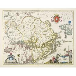
Ducatus Uplandia.
Covers the area of the modern Uppsala land in the vicinity of Stockholm, and includes most of Aland. With a Swedish coat of arms, a figural cartouche with rural people an...
Date: Amsterdam, 1650
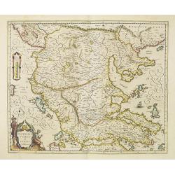
Macedonia, Epirus et Achaia.
Nice map of northern Greece with the southern parts of present day Macedonia and Albania. Includes the region of Athens. Strapwork title cartouche and Spanish text on ver...
Date: Amsterdam, 1650
Imperii Caroli Magni.
Wall map, prepared by Petrus Bertius in 1616. Extensive historical map (four sheets joined) depicting the empire of Charles the Great. Fully engraved with mountains, fore...
- $500 / ≈ €425
Date: Amsterdam, 1650
Estats de la Succession de Cleves/ Iuliers..
Fine map of western Germany.This edition carries the date 1650 and the publishers address A PARIS chez l'Autheur aux Galleries du Louvre. Nicolas Sanson was to bring abou...
Date: Paris 1650
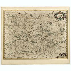
Aniou. . .
Decorative map centered on the Loire valley. Fine title cartouche in upper right corner.
Date: Amsterdam, 1650
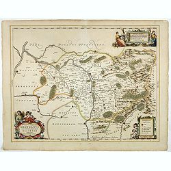
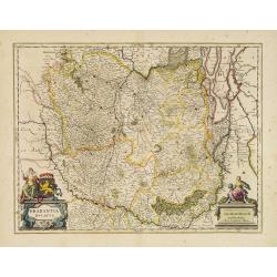
Ducatus Silesiae Grotganus cum Districtu Episcopali Nissensi Delineatore Iona Sculteto, Silesio.
Attractive engraved map of Upper Silesia prepared by Joanus Scultetus, a Silesian cartographer (1603-1664) and published by J. Janssonius. Showing the area around Nysa an...
- $400 / ≈ €340
Date: Amsterdam, 1650
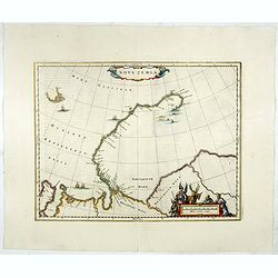
Nova Zemla.
Decorative sea chart decorated with hunters, polar foxes, polar bears and a sea monster.The scalebar in the lower right is in the form of a skewed 'checker-board', to ref...
- $900 / ≈ €765
Date: Amsterdam, 1650
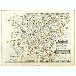
Gouvernement General de l'Ile de France. . .
Fine map of Isle de France, centered on ParisThis edition carries the date 1651. Engraved by Jean Sommer.Nicolas Sanson was to bring about the rise of French cartography,...
- $200 / ≈ €170
Date: Paris, 1651
Nova Haec tabula Galliae. . .
Dated 1653. This handsome map of France is dedicated to Louis XIV, interesting in light of the nearly constant warfare between Louis and the Netherlands in the ensuing ye...
Date: Amsterdam, 1653
Russie avec ses confins...
A rare map published by Jean Boisseau (fl.1637-1658) French geographer, topographer, and genealogist in his Trésor des cartes géographiques. (The first true world atlas...
- $300 / ≈ €255
Date: Paris, 1653
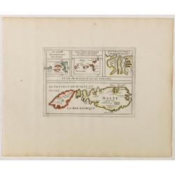
L'Isle de Malte avec ses Voisines./ La Valete Forte..
Uncommon map Malta. Four maps on one sheet. With inset maps of Valletta.Like Sanson, Briet was born in Abbeville and became a Jesuit at age 18. His "Parallela Geogra...
Date: Paris, 1653
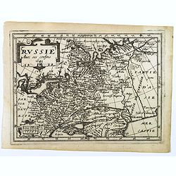
La Russie ou Moscovie.
Scarce map of Russia, centered on Moscow, the map covers much of central Europe, from the Baltic Sea east to the Caspian Sea and from the Arctic Ocean to the Black Sea.Fr...
- $300 / ≈ €255
Date: Paris, 1653
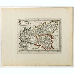
Le Royaume de Sicile.
Uncommon map Sicily and part of Palermo. Very good impression.Like Sanson, Briet was born in Abbeville and became a Jesuit at age 18. His "Parallela Geographiae Vete...
Date: Paris, 1653
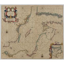
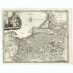
Oost Zee door Arnold Colom.
Large double-page engraved chart of the Baltic Sea, including the coastlines of Finland, Estonia, Latvia, Lithuania, Poland, Denmark, and Sweden, with a decorative inset ...
Date: Amsterdam, c. 1654
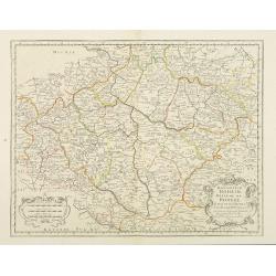
Konigreich Boheim. Royaume de Boheme..
Covering Czech Republic and centered on Prague. This edition carries the date 1654.Nicolas Sanson was to bring about the rise of French cartography, although the fierce c...
Date: Paris, 1654
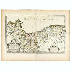
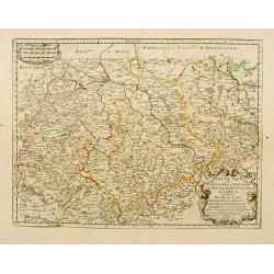
HERTZOGTHUMB POMMERN DUCHE DE POMERANIE divise en ses Princip les Parties qui sont les Princip te de Rugue, Duche de Stettin, Pomeranie, Cassubie, et Wandalie . . .
Very fine map of the northern part of Poland. Nice details of forests, villages and rivers. Two nice uncolored cartouches.Nicolas Sanson was to bring about the rise of Fr...
- $300 / ≈ €255
Date: Paris, 1654
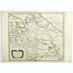
Sarmatia utraque europaea et asiatica. . .
Ancient map of the European part of Russia with the Ukraine. Dated 1654.Nicolas Sanson was to bring about the rise of French cartography, although the fierce competition ...
- $200 / ≈ €170
Date: Paris, 1654
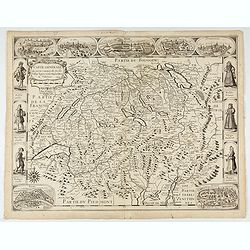
Carte generale des treze cantons de Suisses. Valley Ligues Grise, Maison Dieu et Valteline. 1654
Rare figured border map of Switzerland. In lower corners views of Basel and Zurich. In the top views of Luzern, St. Gallen, Bern, Solothurn and Schaffhausen. In the left ...
Date: Paris, ca. 1654
Konigreich Boheim. Royaume de Boheme. . .
Covering Czech Republic and centered on Prague. Nicolas Sanson was to bring about the rise of French cartography, although the fierce competition of the Dutch would last ...
- $300 / ≈ €255
Date: Paris, 1654
Sarmatia utraque europaea et asiatica. . .
Ancient map of the European part of Russia with the Ukraine. Dated 1654.Nicolas Sanson was to bring about the rise of French cartography, although the fierce competition ...
- $300 / ≈ €255
Date: Paris, 1654
Haute Saxe.. Duche de Saxe... / Marquisat de Misnie..
Fine map of Saxony.This edition carries the date 1655. Engraved by R.Cordier Abbauil.Nicolas Sanson was to bring about the rise of French cartography, although the fierce...
- $100 / ≈ €85
Date: Paris, 1655
L'evesché d'Aire. . .
In center Adour (river), Aire-sur-l'Adour, with Aire and Dax in lower right corner. Janssonius does give credit to Pierre du Val. In lower left corner putti with grapes.D...
- $300 / ≈ €255
Date: Amsterdam, 1656
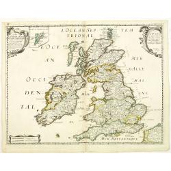
Carte Generale des Royaume d'Angleterre Escosse et Irlande Avecq les Isles circonvoisines Conues toutes soubs le nom de Britanniques / Nouvellement dressee et tiree de Cambdene Spede & autres Par N. Sanson geogr.e Ord.re du Roy
Fine map of the British Isles. The map was first published by Tavernier and later by Mariette. This edition carries the date 1640 and the address of Pierre Mariette: rue ...
- $350 / ≈ €297
Date: Paris, 1640-1657

Moscovia urbs Metropolis totius Russiae Albae.
Detailed bird's-eye town-plan of Moscow from Janssonius' rare townbook. With a key (1-20) to important spots in town. The verso has French text and originates from Jansso...
Date: Amsterdam, 1657
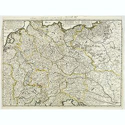
Carte generale de L'Empire d'Allemagne et pays circonvoisins. . .
Fine map of Germany, Low countries, Switzerland, Austria and Poland. The map was first published by Tavernier and later by Mariette. This edition carries the date 1642 an...
- $200 / ≈ €170
Date: Paris, 1642/45-1657

Wassende graade paskaart vertonende alle de Zeekusten van Europa, de geheele middelandsche Zee…
Wassende graade paskaart vertonende alle de Zeekusten van Europa, de geheele middelandsche Zee, als cock ten Noordwesten, en Noordoosten soo veer als ons tot noch toe bek...
Date: Amsterdam, 1658

De Zype. / Purmer / Wormer/ Beemster / Waterland.
Five maps on one sheet. Showing the polders of De Zype, De Purmer, De Wormer, De Beemster and a map of Waterland, including de Bylmermeer and Monnekedam. Showing the Noor...
Date: Amsterdam, 1652-1658
Dicecese de Rheims, et le païs de Rethel. . .
Centered on Rheims. A very decorative map with beautiful cartouches of a province of France by one of the most famous map publishers.
- $300 / ≈ €255
Date: Amsterdam, 1658
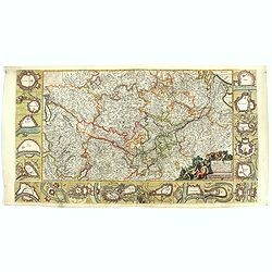
![Magni Ducatus Lithuaniae. . . (together with] Campus Inter Bohum et Borystenem. . .](/uploads/cache/49232-250x250.jpg)
Magni Ducatus Lithuaniae. . . (together with] Campus Inter Bohum et Borystenem. . .
Six sheet wall map of Lithuania and parts of Poland, Russia, Ukraine, Latvia, etc., extending to Cracow, Kyiv, Warsaw, Riga, Konigsberg, Danzig, Leopolis, etc.This is the...
Date: Amsterdam, 1658
Dioecesis Sarlatensis, Vernacule.. Sarlat.
Detailed map of the region south of the Dordogne River, depicting Bergerac, Saint Cyprien, Montignac, Sarlat, Villefranche, etc.Embellished with an impressive title carto...
- $200 / ≈ €170
Date: Amsterdam, 1658
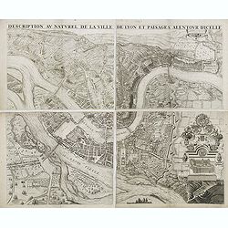
Description au naturel de la ville de Lyon et païsages alentour d'icelle.
PREMIERE EDITION. Plan de Lyon à « vol d’oiseau » commandé par le consulat, destiné à la diffusion et à la notoriété de la cité, mariant ainsi image de la vil...
Date: Lyon, 1659
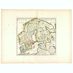
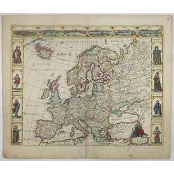
La Scandinavie et les environs ou sont les royaumes de Suede, de Danemarck et de Norwege. . .
The standard map of Scandinavia in 17th century France. Engraved by A.Peyrouin.Nicolas Sanson was to bring about the rise of French cartography, although the fierce compe...
Date: Paris, 1647-1659
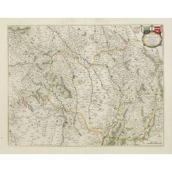
Vera Delineatio Provinciae Fertilissimae Kilan olim Hyrcaniae ad Mare Caspium Sitae.
Uncommon map prepared by Adam Olearius showing the region of Azerbaijan and Iran. The map is oriented with north to the upper left corner and adorned with an attractive t...
- $400 / ≈ €340
Date: Jean Dupuis in Paris, 1659
![[Map of river Rhine.]](/uploads/cache/47453-250x250.jpg)
[Map of river Rhine.]
Map of the River Rhine from Boden See until Wesel. Left hand part of a 2-sheet map.
Date: Amsterdam, 1660
Nova Haec tabula Galliae. . .
Dated 1660. This handsome map of France is dedicated to Louis XIV, interesting in light of the nearly constant warfare between Louis and the Netherlands in the ensuing ye...
Date: Amsterdam, 1660

Pascaarte, van de Zuijderzee, Vliestroom, Vlie, en Amelandergat…
Very rare chart of the Dutch Zuiderzee, here in its rare 5th state (o f6). Showing the coastlines along the Dutch inner sea. Two compass roses indicate north to the left ...
Date: Amsterdam, c. 1660
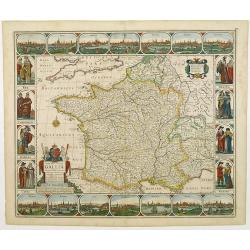
Nova Europae descriptio.
A fine "carte à figures"- map with four panels in columns on each side show portraits of Kings and Queens of European countries. The top border contains panora...
Date: Amsterdam, 1660
Russie blanche ou Moscovie.
Map of the European part of Russia centered on Moscow and prepared by N.Sanson. Published in an early edition of the small Sanson atlas L'Europe Dediée a Monseigneur . ....
- $100 / ≈ €85
Date: Amsterdam, ca. 1660
Carte generalle d'allemaigne nouvellement misse en françois et Ampliffiée de tous les Royaumes. . .
Attractive and rare map of Germany, the Low Countries, Austria, Moravia, Switzerland and part of Poland.
Date: Paris, 1632-1660
Champaigne et Brie etc.
A good engraved map of Champagne-Ardenne area, embellished with decorative title cartouche and scale cartouche with putti and surveying instruments. Paris, Metz, Reims, a...
- $150 / ≈ €127
Date: Paris, ca. 1660

Magnus Ducatus Finlandiae Auct. Andrea Bureo Succo.
The first printed survey map of Finland, composed by the Swedish cartographer Anders Bureus (1571-1661). The map was published in 1662 in the second volume of Joan Blaeu'...
Date: Amsterdam, 1660
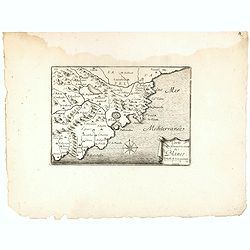
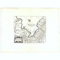
Carte du Gouvernement de Blanes.
Decorative print of the area around Blanes, in Catalonia. Engraved by Pérelle. Embellished with a compass rose.
- $80 / ≈ €68
Date: Paris ca. 1660
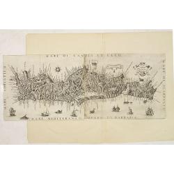
Il Regno Di Candia.
This rare map is based on the important map of Crete by Basilicata. The maps by Marco Boschini reached a wider audience than the few individuals for whom the Basilicata m...
Date: Venice, 1660
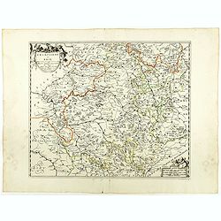
Fluviorum Rheni Mosae Mosellae Moeni Neccaris aliorumque minorum in eosdem se exonerantium et regionum circumjacentium descriptio
Fluviorum Rheni Mosae Mosellae Moeni Neccaris aliorumque minorum in eosdem se exonerantium et regionum circumjacentium descriptio Decorative map with 18 vignettes on thr...
- $750 / ≈ €637
Date: Amsterdam, ca. 1660
Russiae, vulgo moscoviae dictae, partes septentrionalis et orientalis.
A finely engraved depiction of the area from Estonia to Moscow. The map is based on the travels of Isaac Massa, who visited Moscow in the early 1600s and thus was in the ...
- $550 / ≈ €467
Date: Amsterdam, 1660