Browse Listings in Europe
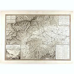
Carte générale des marches, positions, combats et batailles de l'Armée de réserve. . . (N°12)
Very detailed map centered on the Italian Alps showing the marches, positions, combats and battles of the famous Napoleon's crossing the Alps in the year 8 (1799) . In an...
- $750 / ≈ €637
Date: Paris, 1803
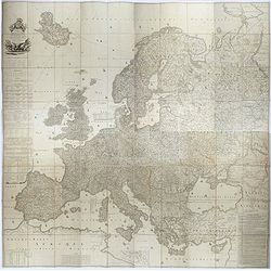
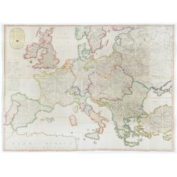
Carte de l'Europe dediée a Son Altesse royale Monseigneur Charles Louis archiduc d'Autriche, prince royal de Hongrie et de Bohéme, chevalier de la Toison d'Or, Grand-Croix de l'ordre...
Probably the largest published map of Europe during the regime of Napoleon.In upper left corner a large title cartouche with coats of arms and a dedication to Archduke Ch...
- $4000 / ≈ €3400
Date: Paris, 1803
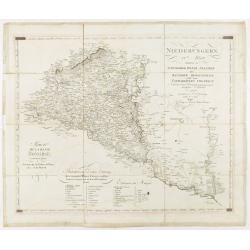
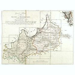
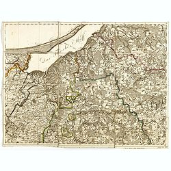
Niederungern Ivtes Blatt enthaltend die Schumegher, Tolner, Baranyer. . . Partie IVè de la basse hongrie contenant les comtes de Schumegh, de Tolna, de Baranya. . .
Map of Hungary. In the lower explicative key. Detailed map of the Southern part of Hungary with Kopreinitz until Lake Balaton, which is one of the most popular summer des...
Date: Kunst u. Industrie Compt., Vienna, 1803
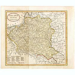
Poland from the best authorities.
Detailed map of Poland from "A New Geographical, Historical, and Commercial Grammar", by William Guthrie. William Guthrie (later engraver for Carey) London, UK....
Date: London, 1805
Die Götha-Elf. Nach Friedr. Akrel's Plancharta öfver Trollhättan reducirt.
Uncommon map prepared by Carl Frederik Akrell. Showing the River Gotha from Gothenburg till Vänersborg.Published by Geographisen Institut in Weimar. A scale in Swedish m...
- $100 / ≈ €85
Date: Weimar, 1805
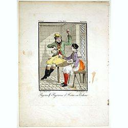
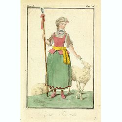
Paysan & Paysanne d'Hanas en Boheme.
Originally hand-colored mezzotint from 'Costumes civils actuels de tous les peuples connus'. Engraved by Lachaussée Jeune after Jacques Grasset de Saint-Sauveur.As an et...
- $50 / ≈ €42
Date: Paris,1805
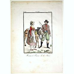
Homme & et Femme de la Sirie.
Originally hand-colored mezzotint from 'Costumes civils actuels de tous les peuples connus'. Engraved by Félix Mixelle after Jacques Grasset de Saint-Sauveur.As an etche...
- $50 / ≈ €42
Date: Paris,1805
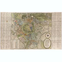
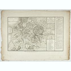
Plan de la ville de Vienne et de ses faubourgs divisés en quartiers.
Fine plan of Vienna, engraved by Franz T. Müller and published by Jean Crappi. On both side an extensive key and a color key to the different sectors in town.
- $900 / ≈ €765
Date: Vienna, 1805
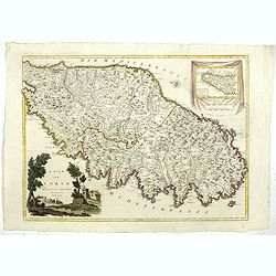
L'Isle de CORSE Divisée en ses departemens.
Nice map of Corsica, with a decorative cartouche in the left low corner. Small inset map of Sicily in the upper right corner: "Pointe de Capo Corso".This is the...
- $1750 / ≈ €1487
Date: Venise,1805
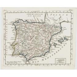
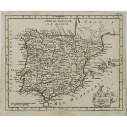
L'Espagne et le Portugal. Divisés Par Gdes. Provinces.
Map of Spain and Portugal, including the Balearic Islands archipelago. From Atlas de la Géographie de toutes les parties du monde .. Ouvrage destiné pour l'education, e...
- $80 / ≈ €68
Date: Paris, Prudhomme, Levrault, Debray, 1806
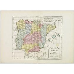
Royaumes d'Espagne et du Portugal.
Map of Spain and Portugal. By C. F. Delamarche, successor of Robert de Vaugondy, Geographer.
- $80 / ≈ €68
Date: Paris, 1794 - 1806
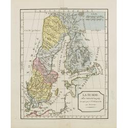
La Suède.
Map of Sweden and Finland. By C. F. Delamarche, successor of Robert de Vaugondy, Geographer.
Date: Paris, ca.1806
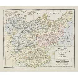
Cercle de Haute Saxe et de Basse Saxe. . .
Map of the duchies of Saxony (upper & lower). By C. F. Delamarche, successor of Robert de Vaugondy, Geographer.
- $50 / ≈ €42
Date: Paris, 1794 - 1806
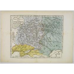
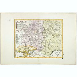
Partie Méridionale de la Russie Européenne, Tartarie, Russienne, Petite Tartarie.
Map of the southern part of Russia and Tartary. By C. F. Delamarche, successor of Robert de Vaugondy, Geographer.
- $90 / ≈ €76
Date: Paris, 1806
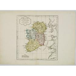
L' Irlande.
Map of Ireland. By C. F. Delamarche, successor of Robert de Vaugondy, Geographer.
- $90 / ≈ €76
Date: Paris, 1794 - 1806
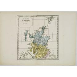
L' Ecosse.
Map of Scotland. By C. F. Delamarche, successor of Robert de Vaugondy, Geographer.
- $50 / ≈ €42
Date: Paris, 1794 - 1806
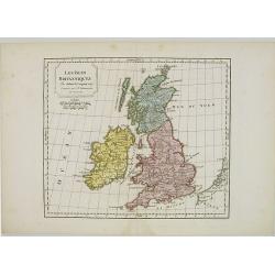
Les Isles Britanniques.
Map of British Isles. By C. F. Delamarche, successor of Robert de Vaugondy, Geographer.
- $80 / ≈ €68
Date: Paris, 1794 - 1806
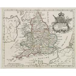
Carte du Royaume d' Angleterre . . .
Map of England and its counties, from Atlas moderne portatif composé de vingt-huit cartes sur toutes les parties du globe terrestre .. A l'usage des Colléges, des Pensi...
Date: Paris, Prudhomme, Levrault, Debray, 1806
L'Allemagne . . .
Map of Germany, from Atlas moderne portatif composé de vingt-huit cartes sur toutes les parties du globe terrestre .. A l'usage des Colléges, des Pensions & des Mai...
- $50 / ≈ €42
Date: Paris, Prudhomme, Levrault, Debray, 1806
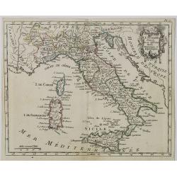
Carte d' Italie . . .
Map of Italy from Atlas moderne portatif composé de vingt-huit cartes sur toutes les parties du globe terrestre .. A l'usage des Colléges, des Pensions & des Maison...
Date: Paris, Prudhomme, Levrault, Debray, 1806
L' Espagne et le Portugal . . .
Map of Spain and Portugal, from Atlas moderne portatif composé de vingt-huit cartes sur toutes les parties du globe terrestre .. A l'usage des Colléges, des Pensions &a...
Date: Paris, Prudhomme, Levrault, Debray, 1806
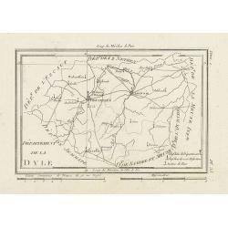
Département de la Dyle.
Map centered on Bruxelles with a short key list in the lower right corner. From Atlas de la Géographie de toutes les parties du monde .. Ouvrage destiné pour l'educatio...
- $40 / ≈ €34
Date: Paris, Prudhomme, Levrault, Debray, 1806
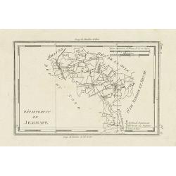
Département de Jemmape.
Map representing the area around Mons, with a short key list in the lower right corner.From Atlas de la Géographie de toutes les parties du monde .. Ouvrage destiné pou...
- $30 / ≈ €25
Date: Paris, Prudhomme, Levrault, Debray, 1806
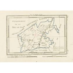
Département de la Meuse Inf.re.
Map representing the area around Maastricht, with a short key list in the lower right corner.From Atlas de la Géographie de toutes les parties du monde .. Ouvrage destin...
- $40 / ≈ €34
Date: Paris, Prudhomme, Levrault, Debray, 1806
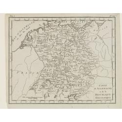
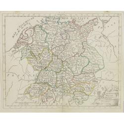
Carte d'Allemagne et de la Republique Helvetique.
Map of central Europe centered on Germany, extending southwards and eastwards to include Poland, the Czech Republic, Austria, Switzerland, Slovenia and part of Italy.From...
Date: Paris, Prudhomme, Levrault, Debray, 1806
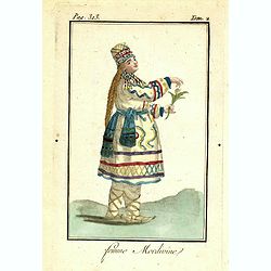
Femme Mordivine.
Originally hand-colored mezzotint of a Mordvinian woman from Ural region dressed in native garb, engraved by Félix Mixelle and Lachaussée Jeune after Jacques Grasset de...
Date: Paris,1801-1806
Femme de Barabinze.
Originally hand-colored mezzotint of a woman from Barabinze, engraved by Félix Mixelle and Lachaussée Jeune after Jacques Grasset de Saint-Sauveur.As an etcher, drawer ...
Date: Paris,1801-1806
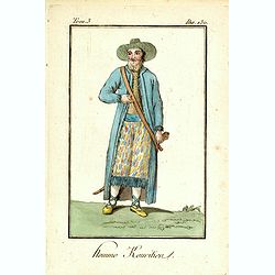
Homme Kouritien.
Originally hand-colored mezzotint of a Siberian man dressed in native garb, engraved by Félix Mixelle and Lachaussée Jeune after Jacques Grasset de Saint-Sauveur.As an ...
Date: Paris,1801-1806
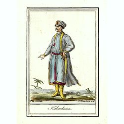
Kabardinien.
Originally hand-colored costume mezzotint of a Kabardian from the Northwest Caucasus, engraved by Félix Mixelle and Lachaussée Jeune after Jacques Grasset de Saint-Sauv...
Date: Paris,1801-1806
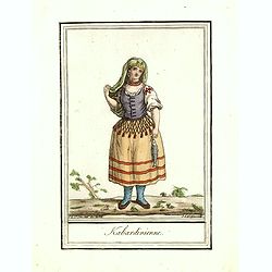
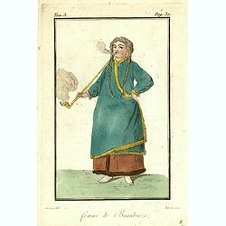
Kabardinienne.
Originally hand-colored costume mezzotint of a Kabardian woman from the Northwest Caucasus, engraved by Félix Mixelle and Lachaussée Jeune after Jacques Grasset de Sain...
Date: Paris,1801-1806
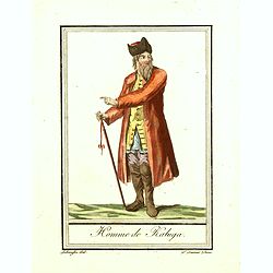
Homme de Kaluga.
Originally hand-colored costume mezzotint of a man from Kaluga engraved by Félix Mixelle and Lachaussée Jeune after Jacques Grasset de Saint-Sauveur.As an etcher, drawe...
Date: Paris,1801-1806
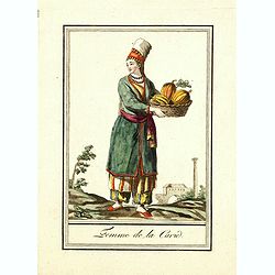
Femme de la Carie.
Originally hand-colored mezzotint costume plate of a woman from the Republic of Karelia, engraved by Félix Mixelle and Lachaussée Jeune after Jacques Grasset de Saint-S...
Date: Paris,1801-1806
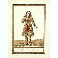
Femme Samoïede.
Originally hand-colored mezzotint of a Samoïede woman engraved by Félix Mixelle and Lachaussée Jeune after Jacques Grasset de Saint-Sauveur.As an etcher, drawer and wr...
Date: Paris,1801-1806
![Fille Mordwine en habits de nôces [together with] Fille Mordwine.](/uploads/cache/36932-250x250.jpg)
Fille Mordwine en habits de nôces [together with] Fille Mordwine.
Set of two originally hand-colored mezzotints of Native Russians engraved by Félix Mixelle and Lachaussée Jeune after Jacques Grasset de Saint-Sauveur.As an etcher, dra...
- $50 / ≈ €42
Date: Paris,1801-1806
![Femme Baschkir [together with] Homme Baschkir.](/uploads/cache/36933-250x250.jpg)
Femme Baschkir [together with] Homme Baschkir.
Set of two originally hand-colored mezzotints of Native Russians engraved by Félix Mixelle and Lachaussée Jeune after Jacques Grasset de Saint-Sauveur.As an etcher, dra...
- $50 / ≈ €42
Date: Paris,1801-1806
![Kirguise [together with] Fille Fatar Kastchintz.](/uploads/cache/36937-250x250.jpg)
Kirguise [together with] Fille Fatar Kastchintz.
Set of two originally hand-colored mezzotints of Native Russians engraved by Félix Mixelle and Lachaussée Jeune after Jacques Grasset de Saint-Sauveur.As an etcher, dra...
- $50 / ≈ €42
Date: Paris,1801-1806
![Homme Fatar Kastchintz [together with] Femme Fatar Kastchintz.](/uploads/cache/36938-250x250.jpg)
Homme Fatar Kastchintz [together with] Femme Fatar Kastchintz.
Set of two originally hand-colored mezzotints of Native Russians engraved by Félix Mixelle and Lachaussée Jeune after Jacques Grasset de Saint-Sauveur.As an etcher, dra...
- $50 / ≈ €42
Date: Paris,1801-1806
![Homme de Tobolsk [together with] Femme Fatar Tobolsk.](/uploads/cache/36939-250x250.jpg)
Homme de Tobolsk [together with] Femme Fatar Tobolsk.
Set of two originally hand-colored mezzotints of Native Russians engraved by Félix Mixelle and Lachaussée Jeune after Jacques Grasset de Saint-Sauveur.As an etcher, dra...
- $50 / ≈ €42
Date: Paris,1801-1806
![Homme Morwine [together with] Femme Mordwine.](/uploads/cache/36920-250x250.jpg)
Homme Morwine [together with] Femme Mordwine.
Set of two originally hand-colored mezzotints of Native Russians engraved by Félix Mixelle and Lachaussée Jeune after Jacques Grasset de Saint-Sauveur.As an etcher, dra...
- $50 / ≈ €42
Date: Paris,1801-1806
![Femme Tscheremisse [together with] Homme Tscheremisse.](/uploads/cache/36921-250x250.jpg)
Femme Tscheremisse [together with] Homme Tscheremisse.
Set of two originally hand-colored mezzotints of Native Russians engraved by Félix Mixelle and Lachaussée Jeune after Jacques Grasset de Saint-Sauveur.As an etcher, dra...
- $50 / ≈ €42
Date: Paris,1801-1806
![Homme Kamtschadale [together with] Femme Kamtschadale.](/uploads/cache/36922-250x250.jpg)
Homme Kamtschadale [together with] Femme Kamtschadale.
Set of two originally hand-colored mezzotints of Native Russians engraved by Félix Mixelle and Lachaussée Jeune after Jacques Grasset de Saint-Sauveur.As an etcher, dra...
Date: Paris,1801-1806
![Femme Samoïede [together with] Homme Samoïede.](/uploads/cache/36923-250x250.jpg)
Femme Samoïede [together with] Homme Samoïede.
Set of two originally hand-colored mezzotints of Native Russians engraved by Félix Mixelle and Lachaussée Jeune after Jacques Grasset de Saint-Sauveur.As an etcher, dra...
- $50 / ≈ €42
Date: Paris,1801-1806
![Femme Ostyack [together with] Homme Ostyack.](/uploads/cache/36924-250x250.jpg)
Femme Ostyack [together with] Homme Ostyack.
Set of two originally hand-colored mezzotints of Native Russians engraved by Félix Mixelle and Lachaussée Jeune after Jacques Grasset de Saint-Sauveur.As an etcher, dra...
- $50 / ≈ €42
Date: Paris,1801-1806
![Kabardinien [together with] Kabardinienne.](/uploads/cache/36925-250x250.jpg)
Kabardinien [together with] Kabardinienne.
Set of two originally hand-colored mezzotints of Native Russians engraved by Félix Mixelle and Lachaussée Jeune after Jacques Grasset de Saint-Sauveur.As an etcher, dra...
- $50 / ≈ €42
Date: Paris,1801-1806
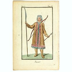
![Homme Jacout [together with] Femme Jacout.](/uploads/cache/36928-250x250.jpg)
Homme Jacout [together with] Femme Jacout.
Set of two originally hand-colored mezzotints of Native Russians engraved by Félix Mixelle and Lachaussée Jeune after Jacques Grasset de Saint-Sauveur.As an etcher, dra...
- $50 / ≈ €42
Date: Paris,1801-1806
![Homme Tongouse [together with] Femme Tongouse.](/uploads/cache/36929-250x250.jpg)
Homme Tongouse [together with] Femme Tongouse.
Set of two originally hand-colored mezzotints of Native Russians engraved by Félix Mixelle and Lachaussée Jeune after Jacques Grasset de Saint-Sauveur.As an etcher, dra...
- $50 / ≈ €42
Date: Paris,1801-1806
![Femme de Tschutskÿ [together with] Homme de Tschutskÿ.](/uploads/cache/36930-250x250.jpg)
Femme de Tschutskÿ [together with] Homme de Tschutskÿ.
Set of two originally hand-colored mezzotints of Native Russians engraved by Félix Mixelle and Lachaussée Jeune after Jacques Grasset de Saint-Sauveur.As an etcher, dra...
- $50 / ≈ €42
Date: Paris,1801-1806
![Fille Barabinze [together with] Homme Barabinze.](/uploads/cache/36931-250x250.jpg)
Fille Barabinze [together with] Homme Barabinze.
Set of two originally hand-colored mezzotints of Native Russians engraved by Félix Mixelle and Lachaussée Jeune after Jacques Grasset de Saint-Sauveur.As an etcher, dra...
- $50 / ≈ €42
Date: Paris,1801-1806
![Femme de Nord-Est-de l'Asie [together with] Homme-Nord-Est de l'Asie.](/uploads/cache/36935-250x250.jpg)
Femme de Nord-Est-de l'Asie [together with] Homme-Nord-Est de l'Asie.
Set of two originally hand-colored mezzotints of Native Russians engraved by Félix Mixelle and Lachaussée Jeune after Jacques Grasset de Saint-Sauveur.As an etcher, dra...
- $50 / ≈ €42
Date: Paris,1801-1806
![Indous [together with] Habitants de la Carie.](/uploads/cache/36936-250x250.jpg)
Indous [together with] Habitants de la Carie.
Set of two originally hand-colored mezzotints of Native Russians engraved by Félix Mixelle and Lachaussée Jeune after Jacques Grasset de Saint-Sauveur.As an etcher, dra...
- $50 / ≈ €42
Date: Paris,1801-1806
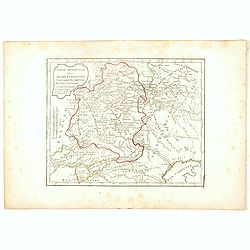
Partie Méridionale de la Russie Européenne, Tartarie, Russienne, Petite Tartarie.
Map of the southern part of Russia and Tartary. The Caspian Sea in lower right corner. By C. F. Delamarche, successor of Robert de Vaugondy, Geographer.
- $50 / ≈ €42
Date: Paris, 1806
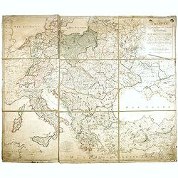
THEATRE Géographique des Guerres du Continent, OU SE TROUVENT EN ENTIER Les Royaumes de Hollande, ...
Large wall map of Central Europe, centered on Poland and including present-day Germany, the Low Countries, Italy, Greece, Bulgaria, Turkey and the Black Sea in the lower ...
Date: Paris, Paul-André Basset, 1806
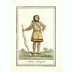
Homme Samojede.
Originally hand-colored mezzotint costume plate of a man from Samojede engraved by Félix Mixelle and Lachaussée Jeune after Jacques Grasset de Saint-Sauveur.As an etche...
Date: Paris,1801-1806
Partie Méridionale de la Russie Européenne, Tartarie Russienne, Petite Tartarie.
Map of the southern part of Russia and Tartary. The Caspian Sea in lower right corner. By C. F. Delamarche, successor of Robert de Vaugondy, Geographer.
- $90 / ≈ €76
Date: Paris, 1806
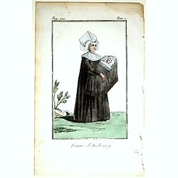
Femme d'Ausbourg.
Originally hand-colored mezzotint from 'Costumes civils actuels de tous les peuples connus'. After Jacques Grasset de Saint-Sauveur. As an etcher, drawer and writer, Gras...
- $50 / ≈ €42
Date: Paris,1806
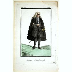
Homme d'Ausbourg.
Originally hand-colored mezzotint from 'Costumes civils actuels de tous les peuples connus'. After Jacques Grasset de Saint-Sauveur. As an etcher, drawer and writer, Gras...
- $50 / ≈ €42
Date: Paris,1806
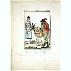
Homme & Femme de la Baviere.
Originally hand-colored mezzotint from 'Costumes civils actuels de tous les peuples connus'. Engraved by Félix Mixelle after Jacques Grasset de Saint-Sauveur.As an etche...
- $50 / ≈ €42
Date: Paris,1806
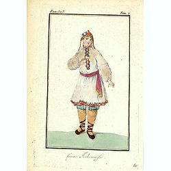
Femme Tschermifse.
Originally hand-colored mezzotint from 'Costumes civils actuels de tous les peuples connus'. Originally hand-colored mezzotint of Native Americans engraved by Félix Mixe...
- $50 / ≈ €42
Date: Paris,1801-1806
Femme Touralinze.
Originally hand-colored mezzotint from 'Costumes civils actuels de tous les peuples connus'. Originally hand-colored mezzotint of Native Americans engraved by Félix Mixe...
- $50 / ≈ €42
Date: Paris,1801-1806
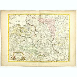
La Pologne Dressée sur ce qu'en ont donné Starovolsk, Beauplan, Hartnoch. . .
This is a late edition of the De L'Isle copper plate with a date of 1806. The copper plate was used many times and has several erased addresses. This one with address &qu...
- $750 / ≈ €637
Date: Paris, 1806
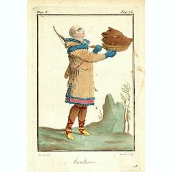
Karakasse.
Originally hand-colored mezzotint of a native Tartary man holding a bear's head engraved by Félix Mixelle and Lachaussée Jeune after Jacques Grasset de Saint-Sauveur. F...
- $25 / ≈ €21
Date: Paris,1801-1806
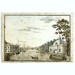
(Die Fontanka beim kaiserlichen Garten in Petersbourg.)
Fontanka River at the Summer Garden in Saint Petersburg. Part of a set of 14 loose and individually mounted plates of views of St. Petersburg and Moscow, plus one plate o...
- $100 / ≈ €85
Date: St. Peterdburg, 1806
![Fille Wotÿake [together with] Femme Wotÿake.](/uploads/cache/36934-250x250.jpg)
Fille Wotÿake [together with] Femme Wotÿake.
Set of two originally hand-colored mezzotints of Native Russians engraved by Félix Mixelle and Lachaussée Jeune after Jacques Grasset de Saint-Sauveur.As an etcher, dra...
- $35 / ≈ €30
Date: Paris,1801-1806
Jacout.
Originally hand-colored mezzotint from 'Costumes civils actuels de tous les peuples connus'. Originally hand-colored mezzotint of Native Americans engraved by Félix Mix...
- $50 / ≈ €42
Date: Paris,1801-1806
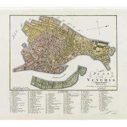
Plan von Venedig.
An uncommon and finely rendered town-plan of Venice. The work is highly detailed and provides a 133-point legend identifying the town's key sites and places of import. L...
Date: Weimar, 1807
(Post Roads of Europe) Neueste Allgemeine Postkarte von Europa in welcher samtliche Postrouten aller europaischen Staaten nach den zuverlässigsten Postbüchern. . .
The largest postal map of Europe, published in Vienna in the midst of the Napoleonic Wars. This postal map of Europe first appeared in 1798 and is considered one of the e...
Date: Vienna, 1807

Karte vom Koenigreiche Ungarn mit Einschluss der Königreiche Kroazien und Slavonien dann von dem Grossfürstenthume Siebenbürgen.
Wall map of the Kingdom of Hungary in 8 sheets mounted on canvas, preserved in their original case. The map has a graduated margin and is enclosed in a simple yet decorat...
Date: Vienna, 1809
(Index sheet) General Tableau zur Karte von Alt Ost und West Preussen nebst dem aufgenommenen Trigonometrischen Netz. . .
Index sheet of this important multi-sheet map of Prussia, Lithuania, and Poland.Section XXIV of the rare first edition of this important 25-sheet map prepared by Friedric...
Date: Berlin, 1802-1810
(Sheet X with Puk Bay from) General Tableau zur Karte von Alt Ost und West Preussen nebst dem aufgenommenen Trigonometrischen Netz. . .
Sheet IV with Zalew Wislany and the towns of Elblag, Paslek, Braniewo, etc, of this important multi-sheet map of Prussia, Lithuania, and Poland.The rare first edition of ...
Date: Berlin, 1802-1810
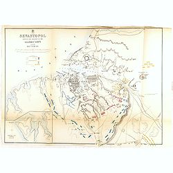
Accueil Consultation Plan du Siège de Danzig par le 10me. Corps de la Grande Armée, Avec les travaux des Français, tels qu'ils étaient le 25 Avril 1807.
A map of the siege of Danzig, 19 March-24 May 1807, showing the positions of the French siege works as they stood on 23 April. Napoleonic Wars (1803-15). Oriented with so...
Date: Paris, after 1810

Carte von West=Gallizien welche auf allerhöchsten Befehl Seiner Kaiserlich oesterreichischen und Königlich apostolischen Majestät in den Jahren 1801 bis 1804. . .
Important early map of Western Galicia, as given to Austria by the third Partition of Poland (1795). Due to its lengthy development period, a rare map rich in detail depi...
Date: Vienna, (1808) after 1811
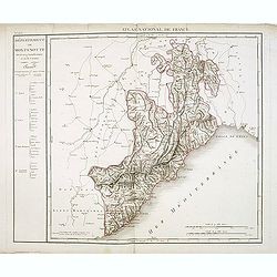
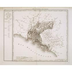
Département de Montenotte Divisé en 4 arrondissemens et en 30 cantons.
Published in the "Atlas National de France" at Chanlaire. Engraved by P.A.F. Tardieu. Represents the department of Apennines which was under French administrati...
Date: Paris, 1790-1811
Département des Apennins Divisé en 3 Arrondissemens et en 18 cantons.
Published in the "Atlas National de France" at Chanlaire. Engraved by P.A.F. Tardieu. Represents the department of Apennines which was under French administrati...
Date: Paris, 1790-1811
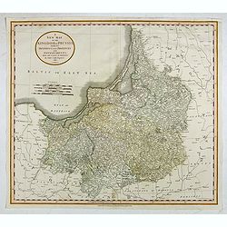
A New Map of the Kingdom of Prussia with its Divisions Into Provinces and Governments. . .
A fine map by John Cary of Prussia, in what is now northern Poland and Lithuania. John Cary was considered "the most representative, able and prolific of English car...
- $250 / ≈ €212
Date: London, 1811
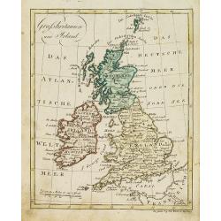
Grossbritanien und Irland.
Nice small map of the British isles and Ireland by Johannes Walch in his rare Allgemeiner Atlas Nach den bewährsten Hülfsmitteln und astronomischen Ortsbestimungen…, ...
- $50 / ≈ €42
Date: Augsburg, 1812
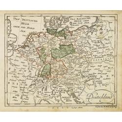
Deutschland (with Poland)
Nice small map of Germany by Johannes Walch in his rare Allgemeiner Atlas Nach den bewährsten Hülfsmitteln und astronomischen Ortsbestimungen…, edition of 1812.Johann...
- $75 / ≈ €64
Date: Augsburg, 1812
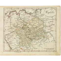
Westphalen.
Nice small map of Westphalia in Germany by Johannes Walch in his rare Allgemeiner Atlas Nach den bewährsten Hülfsmitteln und astronomischen Ortsbestimungen…, edition ...
- $50 / ≈ €42
Date: Augsburg, 1812
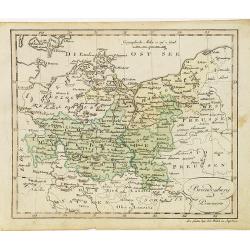
Brandenburg und Pommern.
Nice small map of Brandenburg and Pommeren, centered on Berlin by Johannes Walch in his rare Allgemeiner Atlas Nach den bewährsten Hülfsmitteln und astronomischen Ortsb...
- $75 / ≈ €64
Date: Augsburg, 1812
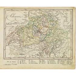
Schweiz.
Nice small map of Switzerland by Johannes Walch in his rare Allgemeiner Atlas Nach den bewährsten Hülfsmitteln und astronomischen Ortsbestimungen…, edition of 1812.Jo...
- $60 / ≈ €51
Date: Augsburg, 1812
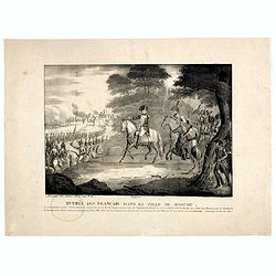
Entrée des Français dans la ville de Moscou . . .
View of the French's army entering Moscow on 14 September 1812 during the Napoleonic Wars (1800-1815) in Russia.
- $75 / ≈ €64
Date: Brussels, ca. 1812