Browse Listings in Europe
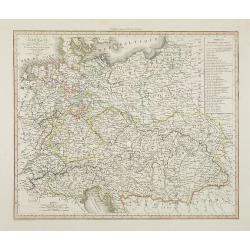
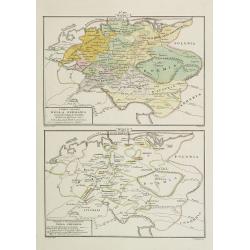
Allemagne . . .
Detailed map of Germany and Austria, prepared by A. H. Basset, rue Saint-Jacques, no. 64, Paris and published in Atlas classique et Universel de Géographie . . . .The en...
- $80 / ≈ €68
Date: Paris, A.H. Basset, 1828
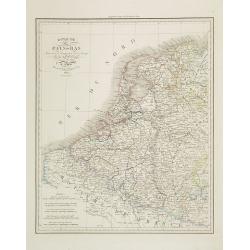
Royaume des Pays-Bas . . .
Detailed map of the Netherlands, Belgium and Luxembourg, prepared by A. H. Basset, rue Saint-Jacques, no. 64, Paris and published in Atlas classique et Universel de Géog...
Date: Paris, A.H. Basset, 1828
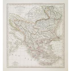
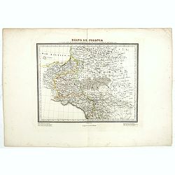
Turquie d'Europe . . .
Detailed map of Grrece, Marcedonia, Bulgaria, Servia, Roumania, prepared by A. H. Basset, rue Saint-Jacques, no. 64, Paris and published in Atlas classique et Universel d...
- $80 / ≈ €68
Date: Paris, A.H. Basset, 1828
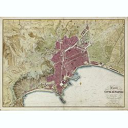
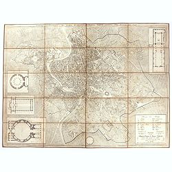
Pianta della Citta di Napoli e de' soui contorni.
Uncommon large scale town-plan of Naples. Drawn and engraved by the "Reale officio topografico".
- $1500 / ≈ €1275
Date: Naples, 1828
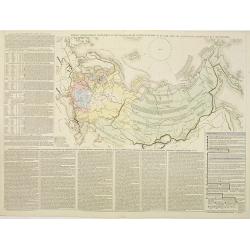
Tablaeu géographique statistique &C. de l'empire Russe actuel en Europe et en Asie avec ses aquisitions graduelles et caractérisées.
Map showing the extension of the Russian Empire at the beginning of the 19th century. Several letterpress notations are present on the map.Surrounding letterpress explana...
Date: Paris, Paul Renouard, 1828
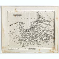
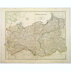
Part of Prussia.
Attractive example of the scarce 1828 Malte-Brun map of modern day Poland and Lithuania. Published by Samuel Walker in 1828 as part of the American edition of Conrad Malt...
- $100 / ≈ €85
Date: Boston, 1828

Pianta Della Citta di Roma con la Indicazione di tutte le Antichita e Nuovi Abbelliment.
Beautifully engraved town plan of Rome, featuring side borders that depict the 16 most important monuments, along with a legend that locates the significant places and bu...
Date: Venanzio Monaldini, Rome, 1829
Pianta topografica di Roma moderna estratta dalla grande del Nolli an 1829
Town plan of Rome based on map by Giovanni Battista Nolli, ( fl. 1692-1756). Engraved by Pietro Ruga. With a key (I - XIV), scale and text "Nuova pianta di Roma mode...
Date: Rome, 1829
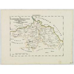
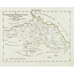
B. Galizische Erbstaaten Koenigr: Galizien Kreis 1. Lemberg 2. Zloczow 3. Zolkiew.
Map depict the western part of the Ukraine, centered on the town of Lviv (Lemberg) the former capital of the region of Galicia. Other cities are Zolkiew, Brody, Belz.From...
- $300 / ≈ €255
Date: Leipzig, G. J. Göschen, ca 1825-1830
![[No title] Russland.](/uploads/cache/28943-250x250.jpg)
[No title] Russland.
Map depict the area north of the Black Sea, including the cities of Odessa, Kischenau, Jelisawetgrad, Kherson.From "W. E. A. von Schliebens Atlas von Europa nebst Ko...
- $250 / ≈ €212
Date: Leipzig, G. J. Göschen, ca 1825-1830
![[No title] Russland.](/uploads/cache/28944-250x250.jpg)
[No title] Russland.
Map depict the area north of the Black Sea, including the cities of Jekaterinoslaw, Bachmut, Alexandrowsk.From "W. E. A. von Schliebens Atlas von Europa nebst Koloni...
- $300 / ≈ €255
Date: Leipzig, G. J. Göschen, ca 1825-1830
Oesterreich. B. Galizische Erbstaaten Koenigr: Galizien Kreis 1. Lemberg 2. Zloczow 3. Zolkiew.
Map depict the area north of the Black Sea, including the cities of Lemberg, Zolkiew, Brody.From "W. E. A. von Schliebens Atlas von Europa nebst Kolonien für Gesch�...
- $150 / ≈ €127
Date: Leipzig, G. J. Göschen, ca 1825-1830
![[No title] Oesterreich. B. Galizische erbstaaten Koenigr. Galizien Kreis 12. Sambor 13. Stry 17. Stanislawow.](/uploads/cache/28948-250x250.jpg)
[No title] Oesterreich. B. Galizische erbstaaten Koenigr. Galizien Kreis 12. Sambor 13. Stry 17. Stanislawow.
Map depict the area north of the Black Sea, including the cities of Stanislawow, Drobicz, Sambor.From "W. E. A. von Schliebens Atlas von Europa nebst Kolonien für G...
- $300 / ≈ €255
Date: Leipzig, G. J. Göschen, ca 1825-1830
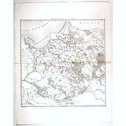
![[No title] Russland. Gouv. 24 Woronesh 28. Slobodsk Ukraine.](/uploads/cache/28949-250x250.jpg)
[No title] Russland. Gouv. 24 Woronesh 28. Slobodsk Ukraine.
Map depict the area north of the Black Sea, including the cities of Kharkow, Achtyrka, Woronesh, etc.From "W. E. A. von Schliebens Atlas von Europa nebst Kolonien f�...
- $300 / ≈ €255
Date: Leipzig, G. J. Göschen, ca 1825-1830
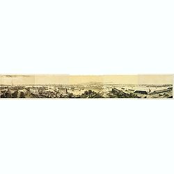
Panorama de Stockholm, Pris de la Coupole de L'Eglise de Skeppsholmen (5 sheets)
Panorama of Stockholm, with numerous captions describing buildings, showing the city as it was in the mid-19th century. On five sheets not joined, total 283 x 2175 mm, fr...
- $400 / ≈ €340
Date: Paris, 1830
Carte du pays compris entre Vistule et la Pregel.
Map of Poland regions, including Warsaw, part of Russia and Danzig bay, prepared by Auguste Henri Dufour (1798-1865). Engraved by Ch. Dyonnet.
- $75 / ≈ €64
Date: Paris, 1830
Carta del Teatro della Guerra in Polonia - 1831.
Oversized rare 1831 war map of Poland and Lithuania published during the Polish - Russian War in 1831, published by Presso l'incisore Stanislao Stucchi. Stucchi, was born...
- $900 / ≈ €765
Date: Milan, 1831
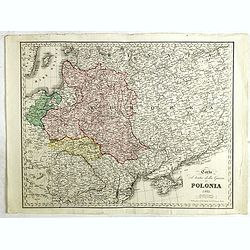
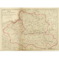
Reino de Polonia ò sea la parte unida a la Rusia por el repartimiento de 1795 que conserva el nombre de aquel antiguo reino.
Uncommon Spanish map of Poland from "Coleccion de mapas geograficos antiguos y modernos de autores clascicos", published by José Torner in Barcelona in 1831.R....
Date: José Torner, Barcelona, 1831
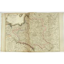
Carte des Etats de Pologne et du Grand Duché de Lithunanie.
Uncommon map of Poland prepared by Sanson and revised by Eustache Hérisson (1759-18.. ) and engraved by Cordier. The map was published by the last family member of the J...
Date: Paris, Jean, 1831
Carte Routière de la Pologne indiquant les partages de ce Royaume…
Carte Routière de la Pologne indiquant les partages de ce Royaume qui ont été faits depuis 1772, 1795 &a". Map prepared by Hérisson and published by Basset. ...
Date: Paris, Basset, 1831

Nouveau Plan Routier de la Ville et Faubourgs de Paris // Avec ses principaux Edifices et Nouvelles Barrieres.
Decorative large-scale wall map of Paris, published by M. P|chon in Paris and engraved by Michel Glot. The plan is framed by a floral border and there are 27 Parisian vie...
Date: Paris, 1834
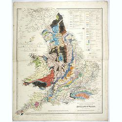
The Inland Navigation, Rail Roads, Geology and Minerals of England & Wales.
A beautifully color-coded and robustly labelled map describes the geology of England and Wales. The colors indicate particular rock materials in accordance with a key at ...
Date: London, 1834
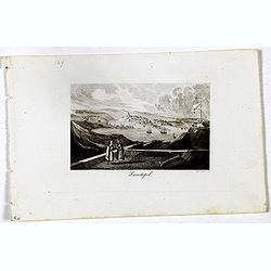
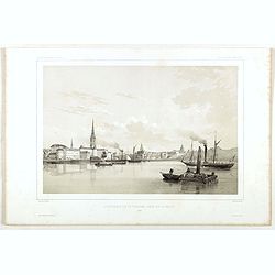
Sewastopol. (Sebastopol)
View of Sebastopol. Engraved by Leopold Zechmayer who was active in Vienna.
- $20 / ≈ €17
Date: Vienna, ca. 1835
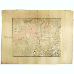
Quartier de Tivoli Nouveaux pereements de Rues.
Plan of the center of Paris showing Tivoli district with Madalene and Clichy. Lithography and pen and ink. Drawn in are the planned workshop of Serrurerie Théophile Mign...
Date: Paris, ca.1835
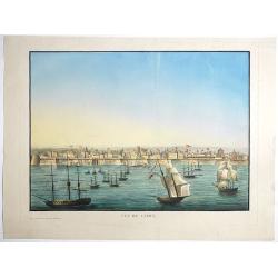
Vue de Cadix.
Very rare view of Cadiz and its seafront drawn and engraved by Renouard, published in Paris by Fatout et Avice, Quai Malaquais, 9. Beautifully hand colored at the time of...
- $2750 / ≈ €2337
Date: Paris, Fatout et Avice, Quai Malaquais 9 , c.1838
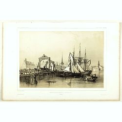
Pont de Knippelsbroe a Copenhague.
View of Knippelsbroe's bridge in Copenhagen. From "Voyage en Scandinavie, en Laponie, etc" - Atlas Pirtoresque (complément). Designed by A.Mayer.
Date: Paris, ca 1834-1838
Stockholm, 2e vue en panorama, prise sur le Velar.
Lithography on tinted grounds. View of Stockholm. From "Voyage en Scandinavie, en Laponie, etc" - Atlas Pirtoresque (complément). Designed by A.Mayer and litho...
Date: Paris, ca 1834-1838

Carte du pays de Montenegro dressée d'après les opérations géodétiques . . .
Rare map of Montenegro prepared by Mr. le Comte Fedor de Karacsay (1787-1859) and engraved by Pietro Allodi. The title is in Russian, Arabic and French.In lower left corn...
Date: Vienna, ca. 1838
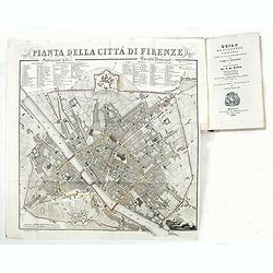
Guide de Florence et de ses environs Redige´ sur un plan entierement nouveau par l'Abbé A. Bulgarini et Traduit en français par A. Le Rendu. Deuxième édition.
Second edition. With 1 engr. folding plan (Pianta della Citta di Firenze. I. Balatri inc. e scris.) and 12 copper plates with views in Florence. The folding plan has meas...
- $550 / ≈ €467
Date: Florence, Gaspard Ricci, 1839
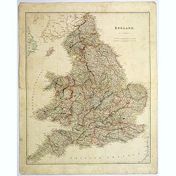
England.
A large and detailed steel engraved map of England, with each county divided by a different color. Many place names and physical features shown - it shows how densely pop...
Date: London, 1839
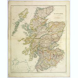
Scotland.
An attractive steel engraved map of Scotland, with each county divided by a different color. Many place names and physical features shown.The Arrowsmith family members we...
Date: London, 1839
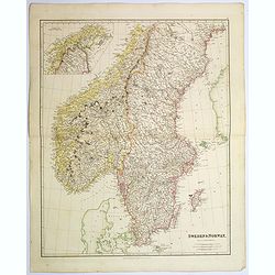
Sweden & Norway.
An attractive steel engraved map of Sweden & Norway. An inset map which is the continuation from Tornea to North Cape. Many place names and physical features shown.Th...
Date: London, 1839
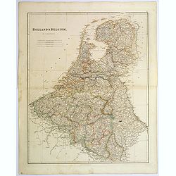
Holland & Belgium.
An attractive steel engraved map of Holland and Belgium. Map flanked by France and Prussia. Duchy of Luxembourg included. Many place names and physical features shown. 4 ...
Date: London, 1839
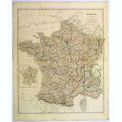
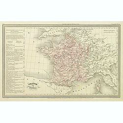
France.
A lovely, large steel engraved map of France, with an inset sketch of France divided into provinces, plus small inset map of the French Mediterranean island of Corsica . ...
Date: London, 1839
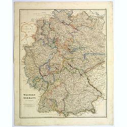
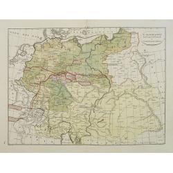
Western Germany.
A lovely, large steel engraved map of Western Germany. Some of the states engraved are: Holstein, Hannover, Mecklenburg, Saxony, Bavaria, Württemberg and Nassau. An extr...
Date: London, 1839
Prussia & Poland.
A glorious, large steel engraved map of Prussia and Poland. Some of the states covered are: Saxony, Pomerania, Posen, Brandenburg, Western & Eastern Prussia and the K...
Date: London, 1839
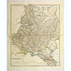
Russia & Poland.
A glorious, large steel engraved map of Russia and Poland. Covering Poland and Finland in the west, as far south as to the very edges of Persia, the Black sea, and to the...
Date: London, 1839
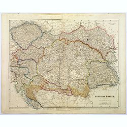
Austrian Empire.
A, large steel engraved map of the mighty Austrian Empire, covering Austria, Dalmatia, Styria, Slavonia, Hungary, Transylvania, Moravia and Bohemia. An enormous amount of...
Date: London, 1839
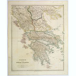
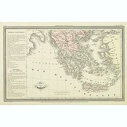
Greece and the Ionian Islands.
A large steel engraved map concentrating on Greece and the Ionian islands. Featured are Albania, Corfu, Macedonia, Central Greece and Morea., along with many small island...
Date: London, 1839
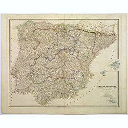
Spain & Portugal.
A large steel engraved map of European neighbours of Spain and Portugal. Including Balearic Islands, with a further inset map of Minorca. Numerous place names and physica...
Date: London, 1839
L'Alemagna . . .
A rare double-page map of Germany and Poland. Prepared by Las Casas and engraved by G.V.Pasquali for l'Atlante Storico, Letterario, Biografico, Archeologico. . . with at...
- $50 / ≈ €42
Date: Venice, 1840
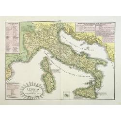
L'Italia antica-romana.
A rare and detailed double-page map of ancient Italy. According to the title cartouche, prepared by A de La Sage for l'Atlante Storico, Letterario, Biografico, Archeologi...
Date: Venice, 1840
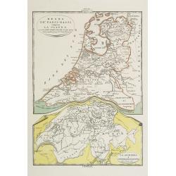
Regno de' Paesi-Bassi compresa la Olanda . . . / La Svizzera . . .
Two rare and detailed maps of The Netherland (210 x 230mm. ) and Switzerland (140 x 230mm.) According to the title cartouche, prepared by J.A.Buchon and A de La Sage for ...
Date: Venice, 1840
I dieci circoli Della Germania . . . / Permute e Secolarizzazioni Nella Germania . . .
Two rare maps of Germany: Top map: 160 x 235mm. Bottom map: 160 x 235mm.Prepared by Las Casas for l'Atlante Storico, Letterario, Biografico, Archeologico. . . with attri...
- $30 / ≈ €25
Date: Venice, 1840
La Germania, suoi ducati e dependenze . . . /Origine e derivazione de principali stati . . .
Two rare maps of ancient Germany: Top map: 160 x 235mm. Bottom map: 160 x 235mm.Prepared by Las Casas for l'Atlante Storico, Letterario, Biografico, Archeologico. . . wi...
- $25 / ≈ €21
Date: Venice, 1840
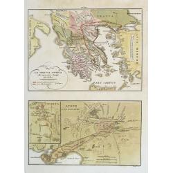
La Grecia Antica . . . / Atene e sue vicinanze . . .
Two rare maps, one of Greece map 175 x 240mm. and the other of Athens 140 x 240mm. with an inset map of Sparta.From l'Atlante Storico, Letterario, Biografico, Archeologic...
Date: Venice, 1840
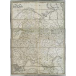
General karte vom europaischen Russland.
Rare second edition of a lithographed wall map of the European part of the Russian empire, at a scale of about 1:3,200,000. With the title in a elaborately decorated lett...
Date: Weimar, Geographisches Institut, 1840
France par Provinces.
Finely engraved map prepared by A.H.Dufour and engraved by Giraldon-Bovinet. Published by Jules Renouard in his uncommon atlas "Le globe Atlas classique Universel de...
- $30 / ≈ €25
Date: Paris, Jules Renouard, ca.1840
Etat de la Grèce.
Finely engraved map of Greece prepared by A.H.Dufour and engraved by Giraldon-Bovinet. Published by Jules Renouard in his uncommon atlas "Le globe Atlas classique Un...
- $50 / ≈ €42
Date: Paris, Jules Renouard, ca.1840
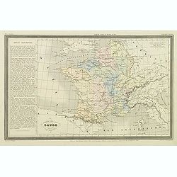
Gaule.
Finely engraved map prepared by A.H.Dufour and engraved by Giraldon-Bovinet. Published by Jules Renouard in his uncommon atlas "Le globe Atlas classique Universel de...
- $20 / ≈ €17
Date: Paris, Jules Renouard, ca.1840
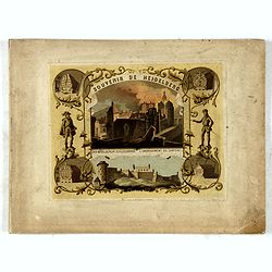
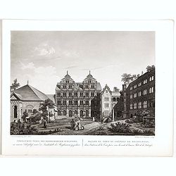
(Title page) Souvenir de Heidelberg.
Cover for a souvenir album with chromolithographed design and entitled: Souvenir de Heidelberg prepared by Louis Charles François. He emigrated with his family in May 17...
- $50 / ≈ €42
Date: Graimberg, Heidelberg, ca. 1840

Wallis's Guide for Strangers Through London.
Engraved plan with original hand-coloring, with title and alphabetical list of the principal streets below. Published by Edward Wellis 42 Skinner Street.With "An alp...
Date: London, E.Wallis, ca. 1840
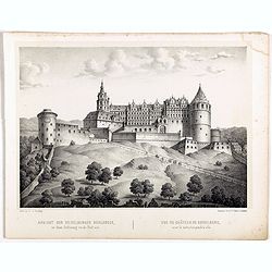
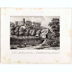
Ansicht der Heidelberger Schlosses. . .
Early lithograph published by Louis Charles François de Graimberg-Belleau. Lithographed by C.F Müller.French artist. Son of Gilles-François Belleau Graimberg. Louis Ch...
Date: Graimberg, Heidelberg, ca. 1840

Vue de la porte Charles. . . Ansicht ded Karlthors . . .
Early aquatint after Louis Charles François de Graimberg-Belleau. Engraved by J.J Tanner.French artist. Son of Gilles-François Belleau Graimberg. Louis Charles Françoi...
Date: Graimberg, Heidelberg, ca. 1840
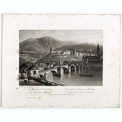
Vue du pont de Heidelberg. Ansicht der Brücke in Heidelberg.
Early aquatint after Louis Charles François de Graimberg-Belleau. Engraved by J.J Tanner.French artist. Son of Gilles-François Belleau Graimberg. Louis Charles Françoi...
Date: Graimberg, Heidelberg, ca. 1840

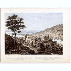
Vue de Heidelberg . . . Ansicht von Heidelberg . . .
Early aquatint after Louis Charles François de Graimberg-Belleau. Lithographed by J.J Tanner.French artist. Son of Gilles-François Belleau Graimberg. Louis Charles Fran...
Date: Graimberg, Heidelberg, ca. 1840
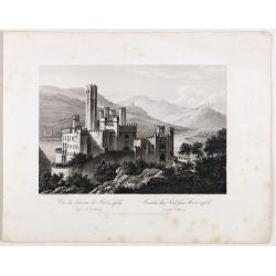
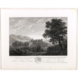
Vue du château de Stolzenfels . . . Ansicht des Schlofses Stolzenfels . . .
Early aquatint after Louis Charles François de Graimberg-Belleau. Lithographed by J.J Tanner.French artist. Son of Gilles-François Belleau Graimberg. Louis Charles Fran...
Date: Graimberg, Heidelberg, ca. 1840

Das grofse Fafs au Heidelberg . Le gros tonneau de Heidelberg.
Engraving after Louis Charles François de Graimberg-Belleau. Engraved by J.J Tanner.French artist. Son of Gilles-François Belleau Graimberg. Louis Charles François emi...
Date: Graimberg, Heidelberg, ca. 1840
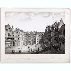
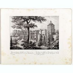
Nördlicher Theil des Heidelberg schlosses. Vue de la partie du nord du château de Heidelberg.
Early lithographs after Louis Charles François de Graimberg-Belleau. Lithographed by C.F Müller.French artist. Son of Gilles-François Belleau Graimberg. Louis Charles ...
Date: Graimberg, Heidelberg, ca. 1840
Nördlicher Theil des Heidelberger schlosses. . . Façade nord du château de Heidelberg . . .
Early aquatint after Louis Charles François de Graimberg-Belleau. Engraved by Hibon and F. Salathé.French artist. Son of Gilles-François Belleau Graimberg. Louis Charl...
Date: Graimberg, Heidelberg, ca. 1840
Vue du château et de la ville de Heidelberg . . . Ansicht des schlosses und der stadt Heidelberger . . .
Engraving after Louis Charles François de Graimberg-Belleau. Lithographed by Ch. Haldennvang.French artist. Son of Gilles-François Belleau Graimberg. Louis Charles Fran...
Date: Graimberg, Heidelberg, ca. 1840

Vue de la ville et du château de Heidelberg . . . Ansicht der stadt und des schlosses Heidelberger . . .
Engraving after Louis Charles François de Graimberg-Belleau. Engraved by Ch. Haldennvang.French artist. Son of Gilles-François Belleau Graimberg. Louis Charles Françoi...
Date: Graimberg, Heidelberg, ca. 1840

Vue du château de Heidelberg . . . Ansicht des Heidelberger schlosses . . .
Engraving after Louis Charles François de Graimberg-Belleau. Engraved by Charles Haldenwang.French artist. Son of Gilles-François Belleau Graimberg. Louis Charles Fran�...
Date: Graimberg, Heidelberg, ca. 1840
Ruines des batimens d' Adolphe et de Robert J au châteaude Heidelberg . . . Die ruinen des Adolfs und Rupruhtsbaues J auf dem Heidelberg . . .
Early lithography after Louis Charles François de Graimberg-Belleau. Lithographed by L. Faure.French artist. Son of Gilles-François Belleau Graimberg. Louis Charles Fra...
Date: Graimberg, Heidelberg, ca. 1840
Le châteaude Heidelberg au commencemment de XVIIe siecle. . . Das Heidelberg schlosse von den acusseren . . .
Early lithography after Merian. Lithographed by L. Faure.French artist. Son of Gilles-François Belleau Graimberg. Louis Charles François emigrated with his family in Ma...
Date: Graimberg, Heidelberg, ca. 1840
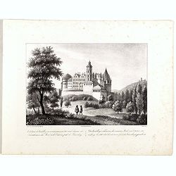
Le châteaude Heidelberg et ses environs . . . Das Heidelberg schlosse mit seinen umgebungen . . .
Early lithographs after Louis Charles François de Graimberg-Belleau. Lithographed by L. Faure.French artist. Son of Gilles-François Belleau Graimberg. Louis Charles Fra...
Date: Graimberg, Heidelberg, ca. 1840
Ansicht des Heidelberger schlosses . . . Vue du château de Heidelberg . . .
Early lithographs after Louis Charles François de Graimberg-Belleau. Lithographed by Salathé.French artist. Son of Gilles-François Belleau Graimberg. Louis Charles Fra...
Date: Graimberg, Heidelberg, ca. 1840
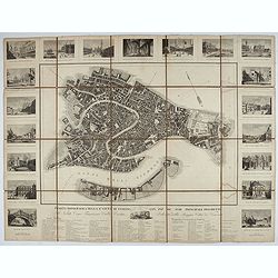
Pianta Topografica della R.a Città di Venezia con XIX de suoi principali prospetti.
A detailed town plan of Venice with an extensive key underneath and nineteen views of the important buildings among which: Piazza di S. Marco, Canal Grande, Tempio della ...
Date: Milan: Santo Vallardi, c.1840
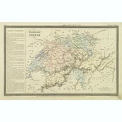
Confédération Suisse.
Finely engraved map of Switzerland prepared by A.H.Dufour and engraved by Giraldon-Bovinet. Published by Jules Renouard in his uncommon atlas "Le globe Atlas classiq...
Date: Paris, Jules Renouard, ca.1840
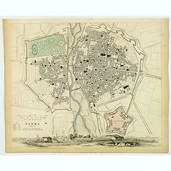
Parma..
A detailed plan of the Italian city of Parma, published by the Society for the Diffusion of Useful Knowledge. The city is divided into two parts by the Parma River. It de...
Date: London, 1840
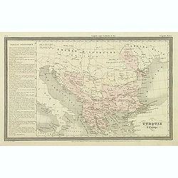
Turquie d'Europe.
Finely engraved map of Greece, Bulgaria, Romania, Albania and the east coast of the Black Sea, prepared by A.H.Dufour and engraved by Giraldon-Bovinet. Published by Jules...
Date: Paris, Jules Renouard, ca.1840
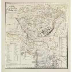
Karte der Kantone St.Gallen und Appenzell.
Scarce. A splendid map of the Swiss Alps, the area south west of the Boden See and west of the River Rhine, centered on Appenzell, St. Gallen.Prepared by Bernet and drawn...
Date: Zürich/ St.Gallen/ Bern, 1840
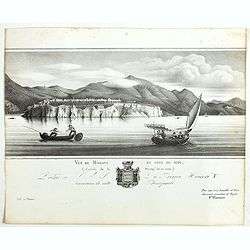
Vue de Monaco du côté du midi . . .
Extremely rare lithographed view of Monaco, lithographed by Jean Baptiste François Bosio, born June 17, 1764 in Monaco, and died July 6, 1827 in Paris, he was a French p...
- $1000 / ≈ €850
Date: Paris, 1841
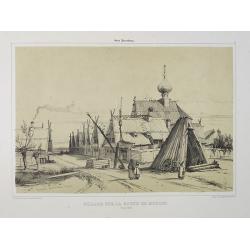
Village sur la route de Moscou. (9 Août 1839).
A view of a village on the way to Saint Petersburg on August 9 1839. Plate taken from the first illustrated account of Russian architecture. This publication was the proj...
Date: Paris, 1842
The Russian Dominions in Europe ... with the Post Roads & New Governments from the Russian Atlas of 1806 by Jasper Nantiat.
A two-sheet wall map of Russia covering from the Artic Sea to the Black and Caspian Seas and from East Prussia and Moldova to the Aral Sea and Tobolsk. Modern day nations...
- $500 / ≈ €425
Date: London, ca. 1843
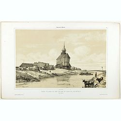
Vieux village et son église en bois du XIIIe siècle près de Rostow.
A view of an old village and its church. Figures are lithographed by Raffet. Plate taken from the first illustrated account of Russian architecture. This publication wa...
- $100 / ≈ €85
Date: Paris, 1844
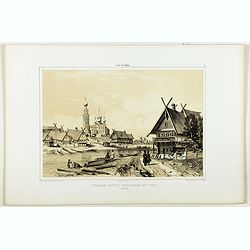
Village entre Novgorod et Tver.
A view of a village between Novgorod and Tver, as on 12 of August 1839. River Volga on foreground. Figures are lithographed by Raffet. Plate taken from the first illustra...
- $150 / ≈ €127
Date: Paris, 1844
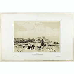
Vue de côté merodional.
A view of the village Vladimir. Figures are lithographed by Raffet. Plate taken from the first illustrated account of Russian architecture. This publication was the proje...
- $150 / ≈ €127
Date: Paris, 1844

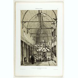
Intérieur de l'église du Monastère de la Ste Trinité.
A view of the Ste Trinity Monastery. Figures are lithographed by Raffet. Plate taken from the first illustrated account of Russian architecture. This publication was the ...
- $100 / ≈ €85
Date: Paris, 1844
Intérieur d'une église en bois, près de Kineschma.
A view of a church's inside, made of wood. Figures are lithographed by Raffet. Plate taken from the first illustrated account of Russian architecture. This publication wa...
- $100 / ≈ €85
Date: Paris, 1844