Browse Listings in Asia
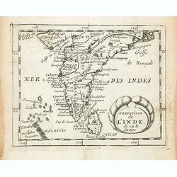
Presqu''isle de L'Inde de ça le Gange.
Uncommon miniature map of India from Pierre Duval's La Geographie Universeille dated 1676. Following his Cartes de geographie in 1657, Pierre Duval published this smaller...
- $150 / ≈ €127
Date: Paris, 1676
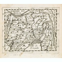
Empire du Mogol.
Uncommon miniature map of the Mongol empire from Pierre Duval's La Geographie Universeille dated 1676. Following his Cartes de geographie in 1657, Pierre Duval published ...
- $150 / ≈ €127
Date: Paris, 1676
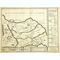
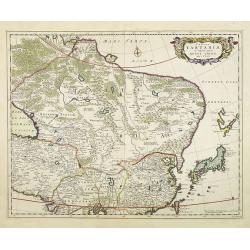
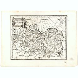
Grande Tartarie vers l'orient où sont le Turquestan, la Tartarie septentrionale, et la Tartarie du Kin. . .
Early edition of this rare map of Tartary which incorporates Turkestan (including East Turkestan), Greater Mongolia, Giacathai.The Great Wall is shown in the lower center...
- $750 / ≈ €637
Date: Paris, 1677
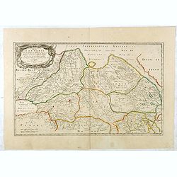
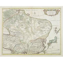
Description de la Tartarie. . .
Detailed map of Tartary, northern China and Korea as an island. The Caspian Sea in the utmost left. Numerous place-names of counties, cities, towns, physical features.Ala...
- $250 / ≈ €212
Date: Paris, 1679
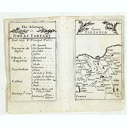
Lesser Tartaria.
A late seventeenth-century English map of Siberia / Tartary.A scarce little map with accompanying engraved text (94x55mm) from "Atlas Minimus, or, A book of geograph...
- $200 / ≈ €170
Date: London, 1679

Carte des Isles du Japon Sequels est remarque la Route..
This uncommon map of Japan, a reduced version of his larger map, contains comments about the nature of the country. For instance, Ocsaqui (Okazaki, near Nagoya) is said t...
Date: Paris / Amsterdam, 1679

Carte des Isles du Japon Esquelles est remarque la Route..
This uncommon map of Japan, on a reasonably large scale, includes comments on the country's nature. For instance, Ocsaqui (Okazaki, near Nagoya) is said to have the most ...
Date: Paris 1679
Naukeurige Beschryving van Asie: behelsende de Gewesten van Mesopotamie, Babylonie, Assyrie, Anatolie, of Klein Asie: beneffens eene volkome Beschrijving van gansch Gellukigh, Woest, en Petreesch of Steenigh Arabie.
Fine large paper copy of this important description of the Near East and Arabia, illustrated with numerous text engravings, 15 double page engraved maps (3) and views (12...
Date: Amsterdam, Jacob van Meurs, 1680
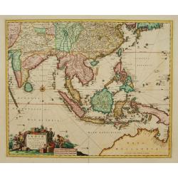
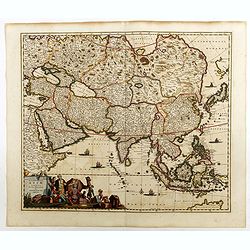
Indiae Orientalis nec non Insularum adiacentium.
Fine map of South East Asia from India to New Guinea with Japan and the southern tip of Korea in the upper right. The map leaves the question of Torres Straits unanswered...
- $1800 / ≈ €1530
Date: Amsterdam, 1680
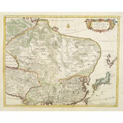
Tabula Tartariae et majoris partis regni Chinae.
Stretching from the Caspian Sea in the west to Formosa in the south-east. Including the peninsula of Korea, Japan and the east coast of Yedso. The Great Wall of China is ...
Date: Amsterdam, 1680
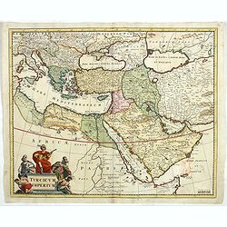
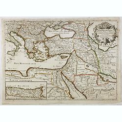
Turcicum Imperium.
Detailed map of the Turkish Empire by Holland's leading mapmaker at the end of the seventeenth century. The cartouche shows an Ottoman administrator or possibly the Sulta...
Date: Amsterdam, 1680
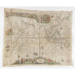
OOST INDIEN Wassende-Graade Paskaart vertoonende nevens het Oostelyckste van Africa meede de Zeekusten van Asia van C. de Bona Esperansa tot Eso boven Iapan / t'Amsterdam by Pieter Goos
Sea chart of the East Indies on Mercator projection delineating not only the eastern coast of Africa, but also the coasts of Asia, from the C. of Good Hope till Eso, nort...
Date: Amsterdam, ca. 1680

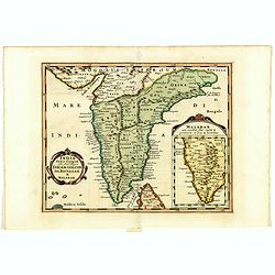
Sinus Gangeticus vulgo Golfo de Bengala Nova descriptio.
Showing the east coast of India and Sri Lanka. West to the top. Decorated with two compass roses, six vessels, a figurative title cartouche and a scale cartouche. The map...
- $500 / ≈ €425
Date: Amsterdam, 1680
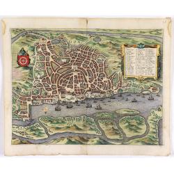
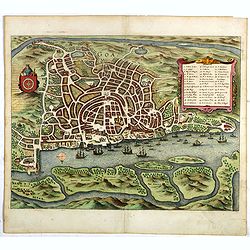
Goa.
A finely engraved, detailed town-plan of Goa, the main Portuguese trading post in India. It also appeared in Gottfried’s Archontologia (1649). There is a cartouche iden...
Date: Frankfurt, 1680

'T Ryk van Persien.
An attractive miniature prepared by N. Sanson. Engraved by A.de Winter.
- $100 / ≈ €85
Date: Amsterdam, Utrecht, Halma, 1680
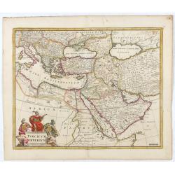
Turcicum Imperium.
Detailed map of the Turkish Empire by Holland's leading mapmaker at the end of the seventeenth century. The cartouche shows an Ottoman administrator or possibly the Sulta...
Date: Amsterdam, 1680
Goa.
A finely engraved, detailed plan of Goa. It also appeared in Gottfried’s Archontologia (1649). There is a cartouche identifying 43 buildings and the plan includes the h...
- $300 / ≈ €255
Date: Frankfurt, 1680

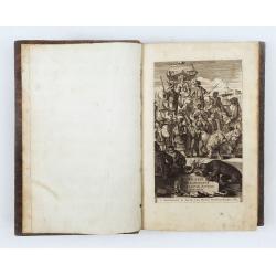
Ambassades mémorables de la Compagnie des Indes orientales des Provinces Unies vers les empereurs du Japon.
First edition in French of this important work on Japan, a work whose illustrations "represent a high-water mark in book illustrations of the 17th century" (Lac...
Date: Amsterdam, 1680
Tabula Tartariae et majoris partis regni Chinae.
Stretching from the Caspian Sea, Central Asia, and the West to Formosa, in the southeast. Including the peninsula of Korea, Japan, Taiwan and the east coast of Yedso. It ...
- $750 / ≈ €637
Date: Amsterdam, 1680

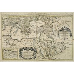
Nova Persiae Armeniae Natoliae et Arabiae.
This fine map shows the area East from Cyprus to Iran, including The Saudi Peninsula, Red Sea, Nile River, Cyprus, Asia Minor, the Gulf of Aden, the Indian Ocean, Armenia...
Date: Amsterdam, 1680
Tabula Tartariae et majoris partis regni Chinae.
Stretching from the Caspian Sea in the west to Formosa in the south-east. Including the peninsula of Korea, Japan and the east coast of Yedso. Decorated with finely engra...
- $800 / ≈ €680
Date: Amsterdam, 1680
Accuratissima totius Asiae tabula..
The map includes a detailed depiction of South East Asia and the Far East. The northern tip of Australia (Hollandia Nova) is shown as are the important discoveries made t...
Date: Amsterdam, 1680

Waere affbeeldinge wegens het casteel ende stadt Batavia.
A good impression of this finely engraved and detailed plan of Batavia, present-day Jakarta, the Dutch center of trading activities in the East Indies. Copied after Cleme...
Date: Amsterdam, 1681
-250x250.jpg)
Hern Johann Baptisten Taveniers..Vierzig Jaehrige Reize..
This German edition includes Tavernier's map of Japan in a reduced form (210x315mm) and contains legends about the country's nature, e.g., where gold is mined and plottin...
Date: Nuremberg, 1681

Il regno della China detto presentente Catay e Magnin. . .
A rare and decorative Italian map of China and Japan, with Japan closely modelled on the indented Cardim outline and Hokkaido, called Yuppi , shown as an Asian peninsula....
Date: Rome, 1682

Jerusalem.
Engraved by Bastiaan Stoopendaal from Juan Bautista Villapando's imaginary town-plan of Jerusalem. This bird's-eye view is surrounded by 12 scenes, views and portraits of...
Date: Amsterdam, 1682
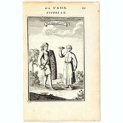
Molucquois (De L'Asie / figure LX).
A fine and uncommon early 17th century print of two people from Moluccas.From the French text edition of "Description d'Univers", 1683. by Allain Manneson Malle...
- $80 / ≈ €68
Date: Paris, 1683
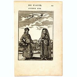
Mongols (De L'Asie / figure LIII).
A fine and uncommon early 17th century print of a Mogol couple.From the French text edition of "Description d'Univers", 1683. by Allain Manneson Mallet (1630-17...
- $80 / ≈ €68
Date: Paris, 1683
Ardeuil ou Ardebil.
A fine and uncommon early 17th century birds-eye view of Ardeuil in Iran, Persia.From the French text edition of Description d'Univers, 1683. by Allain Manneson Mallet (1...
- $80 / ≈ €68
Date: Paris, 1683
Habitants des Isles de la Sonde.
A fine and uncommon early 17th century print of two inhabitants of the Sunda Islands, East Indies (Indonesia).From the French text edition of Description d'Univers, 1683....
- $75 / ≈ €64
Date: Paris, 1683
Tartaria sive Magni Chami imperium.
Detailed and decorative map of Tartary and Northern part of China. Northern tip of Korea included. The Chinese Great Wall is depicted.
- $120 / ≈ €102
Date: Amsterdam, 1683
![Isole dell 'India cioè le Molucche le Filippine e della Sonda . . . [East Indies].](/uploads/cache/39593-250x250.jpg)
Isole dell 'India cioè le Molucche le Filippine e della Sonda . . . [East Indies].
In lower left hand corner a large title cartouche, decorated with mermaids, mermen and playful putti. A scarce, uncommon, late 17th century map of South East Asia, based ...
- $1800 / ≈ €1530
Date: Rome, 1683
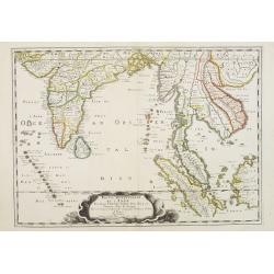
India extra Gangem . . .
Map covering the subcontinent from the Bay of Bengal and the Gulf of Cambay to Ceylon (Sri Lanka) and offers impressive detail given that the interior of India was largel...
- $300 / ≈ €255
Date: Utrecht / Amsterdam, J.Halma, 1683
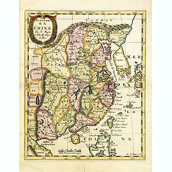
Royaume de la Chine. . .
Detailed map of China. Engraved by A.Winter. Attractive miniature map, depicting Korea as an island and parts of Japan, i.e. western part of Honshu and Kyushu.
- $450 / ≈ €382
Date: Utrecht, 1683
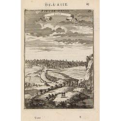
Iedo. (Tokyo)
A late 17th-century miniature view of the skyline of Edo (Tokyo). By Allain Manesson Mallet (1630-1706), a well-traveled military engineer and geographer who worked in 17...
- $200 / ≈ €170
Date: Paris, 1683

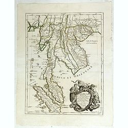
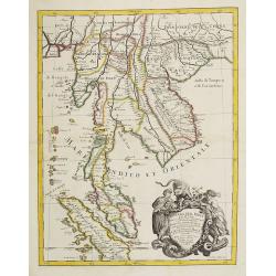
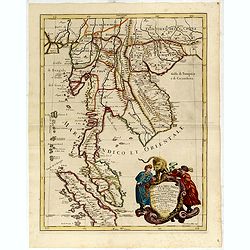
Indiae extra Gangem Pars Septentrionalis. Indiae extra Gangem Pars Meridionalis.
The map on the left depicts the northern portion of the India Ganges region, representing Burma (Myanmar), Thailand, Cambodia, Vietnam and Laos. The right one depicts th...
Date: Utrecht / Amsterdam, J.Halma, 1683
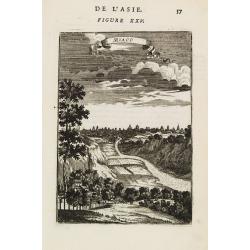
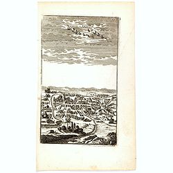
Miaco.
A late 17th-century miniature view of the skyline of Miaco (Kyoto). By Allain Manesson Mallet (1630-1706), a well-traveled military engineer and geographer who worked in ...
- $200 / ≈ €170
Date: Paris, 1683
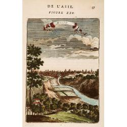
Miaco.
A late 17th-century miniature view of the skyline of Miaco (Kyoto). By Allain Manesson Mallet (1630-1706), a well-traveled military engineer and geographer who worked in ...
- $225 / ≈ €191
Date: Paris, 1683
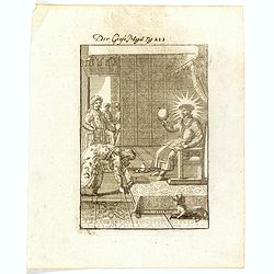
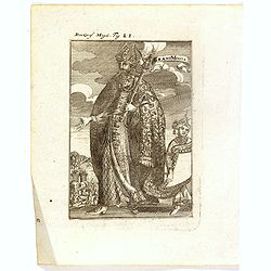
Der Grosse Mogol Fig LII.
A fine and uncommon early 17th century print of a Mogol.By Allain Manneson Mallet (1630-1706), a well traveled military engineer and geographer who worked in 17th century...
- $45 / ≈ €38
Date: Frankfurt, 1684
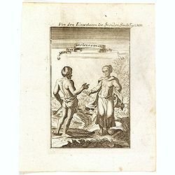
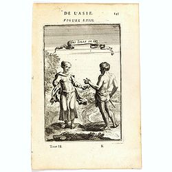
Von den Einwohnerne der Insulen Sonde (Fig LXIII).
A fine and uncommon early 17th century print of two inhabitants of the Sunda Islands, East Indies (Indonesia). Engraved by Joh. Jak. Vogel.By Allain Manneson Mallet (1630...
- $75 / ≈ €64
Date: Frankfurt, 1684

Die Mogoler (Fig LIII).
A fine and uncommon early 17th century print of a couple at time of the Mughal Empire. Engraved by Joh. Jak. Vogel.By Allain Manneson Mallet (1630-1706), a well traveled ...
- $40 / ≈ €34
Date: Frankfurt, 1684
Grant Mogol - Der Graf Mogol (Fig LI).
A fine and uncommon early 17th century print of a Mughal emperor. Engraved by Joh. Jak. Vogel.By Allain Manneson Mallet (1630-1706), a well traveled military engineer and...
- $45 / ≈ €38
Date: Frankfurt, 1684
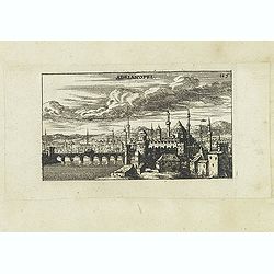
Adrianopel. (Edirne)
Panoramic view of Adrianopel or its modern name Edirne in European Turkey, near the border with Greece and Bulgaria. Published in "Der Donau-Strand Mit allen seinen ...
- $75 / ≈ €64
Date: Nuremberg, Jacob Sandrart, 1684
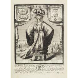
La Reine de la chine.
Very rare and decorative costume plate. In the background : Palais Royal Peking. Beneath the plate a descriptive text about the Queen of China.Bears the address : Se vend...
Date: Paris, ca. 1685
Avrengzebe Roy des Indes Orientales, si zelé po.r. la Religion de Mahomet ..
Very rare and decorative costume plate. Underneath the plate a descriptive text in French.Bears the address : Se vend à Paris chez F. Jollain l aine Rue St Jacques a la ...
Date: Paris, ca. 1685
L'Empire des Turcs en Europe, en Asie et en Afrique.
A nice map showing the Turkish Empire, including an inset map of kingdom of Alger. Extending from Italy and the Eastern Mediterranean in the west to the Caspian Sea and P...
- $550 / ≈ €467
Date: Paris, 1686

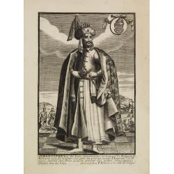
Le Grand Mongol. . .
Rare full portrait of the Mongol emperor of Indostan, published by map seller, François Jollain, the Elder (1641-1704), active in Paris, rue St. Jacques à la ville de C...
Date: Paris, ca. 1686

Paradigma XV Provinciarum et CLV Urbium Capitalium Sinensis Imperij Cum Templis quae Cruce X Signatur Et Domiciliis S.I.
First edition of this rare Jesuit map of China, published by Jean Baptiste Nolin in Paris and based on Philippe Couplet's map of 1686. The map shows China's 15 provinces ...
Date: Paris, 1686
Partie Meridionale de l'Inde en deux presqu'isles. . .
Sanson's important mid-seventeenth century map of India and Southeast Asia, with the engraved date 1686, with the address "Aux Galleries du Louvre" added in bro...
- $800 / ≈ €680
Date: Paris, 1686
Penisola dell India di là dal Gange. . .
Giacomo Rossi's fine late 17th-century map of Malaysia, Thailand, Cambodia and part of Sumatra. Issued in Il Mercurio geografico In the lower right-hand corner a large ti...
Date: Rome, 1683-1688
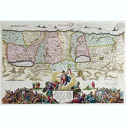
Het Beloofde Landt Canaan door wandelt onser Saligmaecker Jesu Christo neffens sijne Apostelen.
Fine map of the Land of Canaan or the Promised Land with north oriented to right. Large decorative title cartouche at bottom surrounded by vignettes depicting birth, deat...
Date: Amsterdam, 1688
Penisola Dell India di la dal Gange Diusa ne i Regni, che in essasi contengono et accresciuta di varie notizie. Da Giacomo Cantelli da Vignola e conforme le Relationi di alcuni Padri della Compa di Giesu di Monsu Tavernier . . .
Giacomo Rossi's fine late 17th-century map of Malaysia, Thailand, Cambodia and part of Sumatra. The region is shown divided into kingdoms, including Tonkin, Cochinchina, ...
Date: Rome, 1683-1688
Penisola Dell India di la dal Gange Diusa ne i Regni, che in essasi contengono et accresciuta di varie notizie. Da Giacomo Cantelli da Vignola e conforme le Relationi di alcuni Padri della Compa di Giesu di Monsu Tavernier . . . 1683
Giacomo Rossi's fine late 17th century map of Malaysia, Thailand, Cambodia and part of Sumatra.. Engraved by Franciscus Donia. Issued in Il Mercurio geografico In lower r...
Date: Rome, 1683-1688
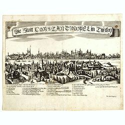
Constantinopolitanae urbis effigies ad vivum expressa.
Extremely rare panoramic view of Istanbul published by Jacob Koppmayr. With a numbered key (1-29) to principal places in town. Jacob Koppmayr was a printer and publisher ...
- $900 / ≈ €765
Date: Augsburg, 1689
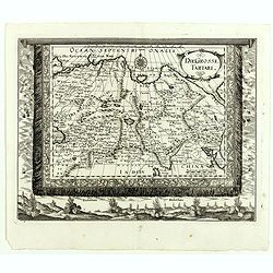
Die Grosse Tartari.
Rare map showing Siberia, Korea, with part of the Caspian Sea to the West, as well as India and North Russia. The title is in an oval cartouche in the upper right cornerT...
- $1000 / ≈ €850
Date: Augsburg, 1689
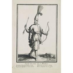
Garde du corps de sa Hautesse. . .
Beautiful engraving by Henri Bonnart (1642?-1711) vis-à-vis les Mathurins au Coq. Printed with the privilege of the King.
Date: Paris, c. 1690

Kam Hi Fils de Chien chi Empereur des Tartares orientaux?.plusieurs titres d'honneur Ecrits de sa propre main.
Very rare and decorative costume plate. Underneath the plate a descriptive text in French. Bears the address AParis Chez Nolin rue St. Jacques à l'Enseigne de la Place d...
- $300 / ≈ €255
Date: Paris ca. 1690
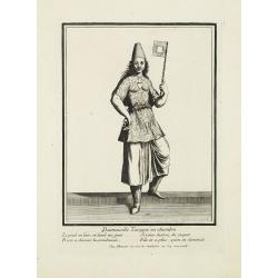
Damoiselle Turcque en chambre. . .
Beautiful engraving by Henri Bonnart (1642?-1711) vis-à-vis les Mathurins au Coq. Printed with the privilege of the King.
Date: Paris, 1690

Femme Turque vestue a la moresque.
Beautiful engraving by Henri Bonnart (1642?-1711) vis-à-vis les Mathurins au Coq. Printed with the privilege of the King.
Date: Paris, 1690
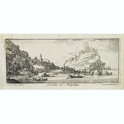
Fanar nel Arcipelago. (Phanar)
Magnificent bird's-eye town-view of Fanar or Phanar, a neighborhood midway up the Golden Horn, within the district of Fatih in Istanbul. Engraved by Lucas Vostermans II, ...
- $150 / ≈ €127
Date: Antwerp, c.1690
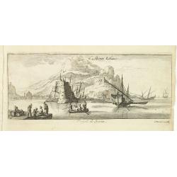
Ladimistri nel arcipelago. (Edremit)
Magnificent bird's eye-town-view of Edremit on the west coast of Turkey, not far from the Greek island Lesbos. It is situated at the tip of the gulf with the same name (G...
- $150 / ≈ €127
Date: Antwerp, c.1690
Satalia nel arcipelago. (Antalya)
Magnificent bird's eye-town-view of Antalya. Engraved by Lucas Vostermans II, who was born in 1624, in the same year when the family moved to England for six years. He wa...
- $150 / ≈ €127
Date: Antwerp, c.1690
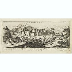
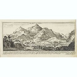
Het dal Terebinthus in Arabia.
Magnificent bird's eye- of Terebinthus north of Hebron. Etched by Gaspar Bouttats (1640-1695).The Antwerp-based publisher Jacques Peeters published ca. 1690 a series of p...
- $150 / ≈ €127
Date: Antwerp, c.1690
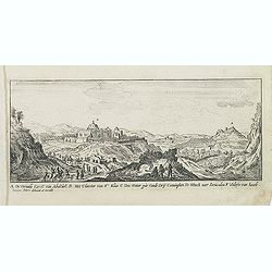
A. De Verualle Kerck Van Abakuck. . . .
Magnificent bird's eye- of Abakuck. Etched by Gaspar Bouttats (1640-1695).The Antwerp based publisher Jacques Peeters published ca. 1690 a series of prints related to the...
- $150 / ≈ €127
Date: Antwerp, c.1690
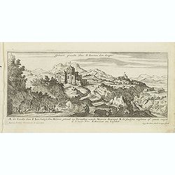
Gebort Plaedt Van S Ioannes des dooper. [Bith place of John Baptist)
Magnificent view of birthplace of John Baptist. Etched by Gaspar Bouttats (1640-1695).The Antwerp based publisher Jacques Peeters published ca. 1690 a series of prints re...
Date: Antwerp, c.1690
Den Bergh van olmeten. (Mount of Olives).
Magnificent view of the Mount of Olives, with the Church of the Ascension. Etched by Gaspar Bouttats (1640-1695).The Antwerp based publisher Jacques Peeters published ca....
Date: Antwerp, c.1690
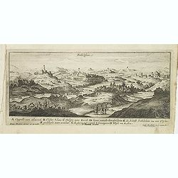
Bethlehem.
Magnificent bird's eye- of Bethlehem. Etched by Gaspar Bouttats (1640-1695).The Antwerp based publisher Jacques Peeters published ca. 1690 a series of prints related to t...
Date: Antwerp, c.1690
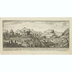
Jerusalem.
Magnificent bird's eye- of Jerusalem. Etched by Gaspar Bouttats (1640-1695).The Antwerp based publisher Jacques Peeters published ca. 1690 a series of prints related to t...
Date: Antwerp, c.1690
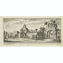
Gesicht in Jerusalem.
Magnificent bird's eye- of Jerusalem. Etched by Gaspar Bouttats (1640-1695).The Antwerp based publisher Jacques Peeters published ca. 1690 a series of prints related to t...
Date: Antwerp, c.1690
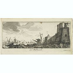
Gli Dardanelli.
Magnificent bird's eye- of Dardanelle street at the Aegean Sea. Etched by Gaspar Bouttats (1640-1695).The Antwerp based publisher Jacques Peeters published ca. 1690 a ser...
Date: Antwerp, c.1690

Mocha, in Arabien. (View of Mocha, Yemen.)
Magnificent bird's eye-town-view of Mocha in Yemen.. Etched by Gaspar Bouttats (1640-1695).The Antwerp based publisher Jacques Peeters published ca. 1690 a series of prin...
Date: Antwerp, c.1690
Tripoli de Soria.
Magnificent bird's eye- of Tripoli in Lebanon. Tripoli is located 85 km north of the capital Beirut, and is the easternmost port of Lebanon. Etched by Gaspar Bouttats (16...
- $100 / ≈ €85
Date: Antwerp, c.1690

Quantung, e Fokien, Provincie della China...
A beautifully engraved decorative map of Southern China extending from Hainan in the West to Formosa in the East and centered on the Pearl River Delta with Macao and the ...
Date: Venice, 1691
![[Arabia]](/uploads/cache/40143-250x250.jpg)
[Arabia]
A lovely miniature map of the region of Armenia and Georgia, showing both parts of the Black Sea and Caspian Sea. For such a small map, it renders a wealth of detail, wit...
Date: Ulm, 1692
Isola del Giapone e penisola di Corea.
A most attractive and decorative map of Japan and its near neighbour Korea by Vincenzo Coronelli. An elaborate central title cartouche garlanded with intertwined flowers ...
Date: Venice, 1692
Iudaea seu terrasancta quae Hebraeorum sive Israelitarum. . .
Fine map of the Holy Land with a decorative title and scale cartouche.Alexis-Hubert Jaillot (1632-1712), was a French cartographer. He joined the Sanson heirs and redrew ...
Date: Amsterdam, 1692

Isola del Giapone e penisola di Corea.
A most attractive and decorative map by Vincenzo Coronelli. An elaborate central title cartouche garlanded with intertwined flowers and dedicated to the Rev.de Fontaine o...
Date: Venice, 1692
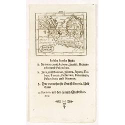
Insulae Sondae.
Rare small map of South East Asia, from "Kurtze bundige abbild und vorstellung der gantzen welt." by Johann Ulrich Muller. A second edition was published in Fra...
- $300 / ≈ €255
Date: Ulm, 1692
Estats de l'empire du grand seigneurs des turcs. . .
The map represents the Ottoman Empire based on Sanson's 1654 map. The Arabian Peninsula is shown with much detail including towns, villages, mountains and watercourses an...
Date: Amsterdam, 1692

Het gezandtschap der Neerlandtsche Oost-Indische Compagnie, aan den grooten Tartarischen Cham, Den tegenwoordigen Keizer van China. . .
Third edition of this beautifully illustrated work on China. The first edition was published in 1665.Jan Nieuhof was a "Dutch traveler and adventurer" (1618-72)...
Date: Amsterdam, W. Waasberge, 1693