Browse Listings in Asia
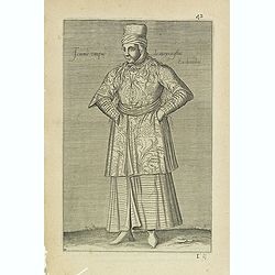
Femme Turque de moyen estat En chambre. (42)
Sought-after copper engraved plate from Laonikos Chalcocondyle’s "L'histoire de la décadence de l'empire grec et establissement de celuy des Turcs." by Thoma...
Date: Paris, Mathieu Guillemot, 1650
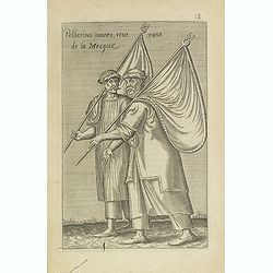
Pellerins mores, reue nuns de la Mecque.
Sought-after copper engraved plate from Laonikos Chalcocondyle’s "L'histoire de la décadence de l'empire grec et establissement de celuy des Turcs." by Thoma...
Date: Paris, Mathieu Guillemot, 1650

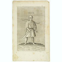
Azamoglan Rustique .(12)
Sought-after copper engraved plate taken from Laonikos Chalcocondyle’s "L'histoire de la décadence de l'empire grec et establissement de celuy des Turcs." by...
Date: Paris, Mathieu Guillemot, 1650
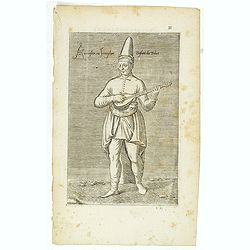
Azaoglan ou Iamoglan Enfant du tribut. (11)
Sought-after copper engraved plate taken from Laonikos Chalcocondyle’s "L'histoire de la décadence de l'empire grec et establissement de celuy des Turcs." by...
- $50 / ≈ €42
Date: Paris, Mathieu Guillemot, 1650
Azzappi. (10)
Sought-after copper engraved plate from Laonikos Chalcocondyle’s "L'histoire de la décadence de l'empire grec et establissement de celuy des Turcs." by Thoma...
- $50 / ≈ €42
Date: Paris, Mathieu Guillemot, 1650

Iannissaire Allant à la Guerre. (9)
Sought-after copper engraved plate from Laonikos Chalcocondyle’s "L'histoire de la décadence de l'empire grec et establissement de celuy des Turcs." by Thoma...
Date: Paris, Mathieu Guillemot, 1650

Iannissaire ou Ianissarler Soudart a Pied de la Garde Ordinaire du Grand Seigneur. (8)
Sought-after copper engraved plate from Laonikos Chalcocondyle’s "L'histoire de la décadence de l'empire grec et establissement de celuy des Turcs." by Thoma...
Date: Paris, Mathieu Guillemot, 1650
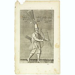
Solachi ou Solacler, Archer Ordinaire de la Garde du Grand Seigneur. (7)
Sought-after copper engraved plate taken from Laonikos Chalcocondyle’s "L'histoire de la décadence de l'empire grec et establissement de celuy des Turcs." by...
Date: Paris, Mathieu Guillemot, 1650
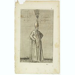
Boluch Bassi Capitaine de Cent Janissaires. (6)
Sought-after copper engraved plate from Laonikos Chalcocondyle’s "L'histoire de la décadence de l'empire grec et establissement de celuy des Turcs." by Thoma...
Date: Paris, Mathieu Guillemot, 1650
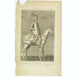
Calidesquer. (5)
Sought-after copper engraved plate from Laonikos Chalcocondyle’s "L'histoire de la décadence de l'empire grec et establissement de celuy des Turcs." by Thoma...
Date: Paris, Mathieu Guillemot, 1650
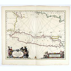
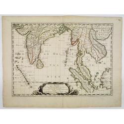
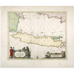
Insulae Iavae Cum parte insularum Borneo Sumatrae..
An elegant sea chart of the island of Java with parts of Sumatra, Borneo and Bali. The map includes only coastal detail and shows the Dutch capital in the East Indies at ...
Date: Amsterdam, 1652
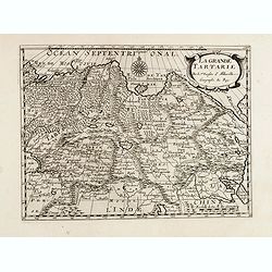
La grande Tartarie.
Map of Central Asia showing major cities, places and water bodies. Relief shown pictorially. Engraved by Anthony de Winter.
- $150 / ≈ €127
Date: Amsterdam, Utrecht, ca. 1653
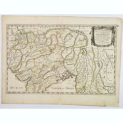
L'Inde deca et dela le Gange, ou est L'Empire du Grand Mogol. . .
An excellent mid 17th century map showing the area from Afghanistan and Pakistan in the west, and western China on the east, with most of India and extending north to the...
- $100 / ≈ €85
Date: Paris, 1654

Carte des Trois Arabies. Tiree en Partie de l'Arabe de Nubie, en Partie de Divers autres Autheurs. . .
Rare map of the Arabian Peninsula, first published in 1654 and one of the first large maps focused specifically on the Arabian Peninsula. Sanson's map of the Arabian Peni...
Date: Paris, 1654
![Les Isles Philippines [on sheet with] Islas de los Ladrones ou Isle des Larrons.](/uploads/cache/42023-250x250.jpg)
Les Isles Philippines [on sheet with] Islas de los Ladrones ou Isle des Larrons.
Sanson's important mid-seventeenth-century map of the Philippines and tha Ladrones.It was first engraved by J. Somer for the elder Nicolas Sanson with a privilege for twe...
Date: Amsterdam/Utrecht, 1654
Partie Meridionale De L'Inde En deux Presqu'Isles l'une deca et l'autre Gange . . . 1654
Sanson's important mid-seventeenth-century map of India and Southeast Asia. At a scale of about 1:9,000,000, it covers most of modern India, Bangladesh and Burma, the who...
Date: Paris, 1654
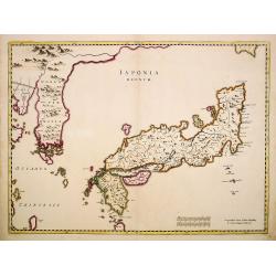
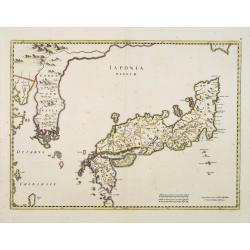
Japonia Regnum.
The first map to correctly show Korea as a peninsula. This was to remain the standard form of Japan until the eighteenth century and although replaced by the maps of Rela...
Date: Amsterdam, 1655

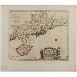
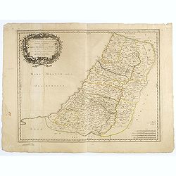
Terra Promissions.
A beautifully executed and very rare map of the Promised Land, divided into the 12 Tribes. The shore line runs in north-southwesterly direction from Sidon as far as Pelus...
Date: Paris, c.1655
Japonia Regnum.
It is the first map to correctly show Korea as a peninsula.This was to remain the standard form of Japan until the eighteenth century and although replaced by the maps of...
Date: Amsterdam, 1655
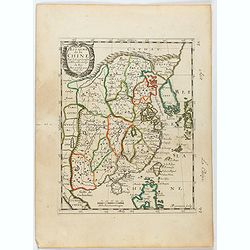
Royaume de la Chine. . .
Detailed map of China. Engraved by A.Winter. Attractive miniature map, depicting Korea as an island and parts of Japan, i.e. western part of Honshu and Kyushu.
Date: Paris, 1656
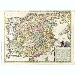
La Chine Royaume. . .
An important and attractive French map of the whole of China, northern tip of the Philippines, with a strangely curved Korea and an under-sized Taiwan here called "Y...
Date: Paris, 1656
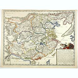
La Chine Royaume. . .
An important and attractive French map of the whole of China, the northern tip of the Philippines, with a strangely curved Korea and an under-sized Taiwan here called &qu...
- $2600 / ≈ €2210
Date: Paris, 1656
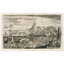
View of Derbendt an der Persischen Grentze.
An early view of Derbent, in the Republic of Dagestan. From "Voyages en Moscovie, Tartarie et Perse, par Adam Olearius".Adam Olearius was a seventeenth-century ...
Date: Paris, Abraham de Wicquefort , 1656
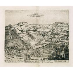
Tarku Urbs Tartaroum in Dagestan ad mare Caspium.
An early view of Tarku, in the Republic of Dagestan. From "Voyages en Moscovie, Tartarie et Perse, par Adam Olearius".Adam Olearius was a seventeenth-century G...
Date: Paris, Abraham de Wicquefort , 1656
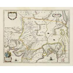
Magni Mogolis Imperium.
An attractive map of the northern part of India, Tibet, Iran to Burma. The travel route from Kabul to Surat is the most prominent feature of the map. Richly decorated wit...
- $650 / ≈ €552
Date: Amsterdam, 1658
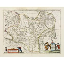
Tartaria sive Magni Chami imperium.
This is a detailed and decorative map of the Tartary and northern part of China, including the Chinese Great Wall, the Caspian Sea, and the Volga River east as far as the...
- $700 / ≈ €595
Date: Amsterdam, 1658
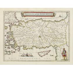
Natolia, quae olim Asia minor.
A finely designed map of Turkey and Cyprus from the great Blaeu family of Amsterdam. The decoration consist of a colored title cartouche, sea monsters, a naval engagement...
- $450 / ≈ €382
Date: Amsterdam, 1658
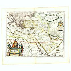
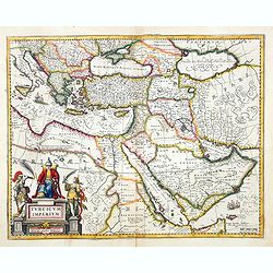
Turcicum Imperium.
A very handsome map with a particularly fine cartouche showing the Turkish Sultan on his throne and allegorical figures at either side brandishing weapons. At right is a ...
- $1500 / ≈ €1275
Date: Amsterdam, 1658
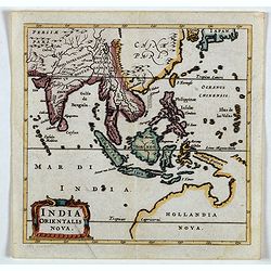
India Orientalis Nova.
Charming uncommon miniature map showing the northern two-thirds of Australia pre-discoveries by Captain Cook, but showing discoveries by Abel Tasman in 1642. The map show...
- $750 / ≈ €637
Date: Amsterdam, 1659
Insulae Iavae Cum parte Insularum Borneo Sumatrae, et Circumjacentium Insularum Novissima Delineatio.
This elegant chart focuses on the island of Java with parts of Sumatra, Borneo and Bali. The lack of interior detail correctly reflects the state of knowledge of the peri...
Date: Amsterdam, 1660
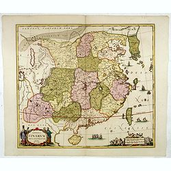
Quantung Imperii Sinarum Provincia duodecima.
A beautifully engraved map of Southern China covers Hainan, the Pearl River Delta, and Greater Hong Kong.A legend at left identifies cities and towns of various sizes, fo...
Date: Amsterdam, 1660
Imperii Sinarum nova descriptio.
Schenk and Valk's rare early 18th century issue of Janssonius milestone map of China, Korea and Japan after Martino Martini. Engraved by Johannes van Loon. The overall ba...
- $1600 / ≈ €1360
Date: Amsterdam, ca. 1660

Pecheli, Xansi, Xantung, Honan, Nanking, In plaga Regni Sinensis. . .
A map of the northern provinces of China after the Jesuit Martino Martini, depicting of Hebei (Pecheli), Shanxi (Xansi), Shandong (Xantung), Henan (Honan), and Jangsu (Na...
Date: Amsterdam, ca 1660

Fokien Imperii Sinarum Provincia undecima.
The province of Fokien lies opposite Taiwan and south of the region described in the above map. The coast is shown from Wen-zhou in the north to Fu-zhou and as far south ...
Date: Amsterdam, 1660

Sumatrae et insularum Locorumque nonnullorum circumiacentium. . .
Fine depicting the Island of Sumatra and the southern coasts of Malaysia from Quedo to Johore.North is orientated to the left of the page.Singapore is probably identifie...
Date: Amsterdam, 1660
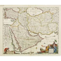
Nova Persiae, Armeniae, Natoliae et Arabiae.
East from Cyprus to Iran with numerous place names and ornamental cartouches below. There are vignettes of sailing ships in sea areas and the land divisions of the time a...
- $850 / ≈ €722
Date: Amsterdam, 1660
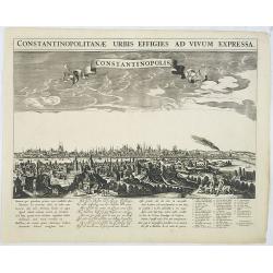
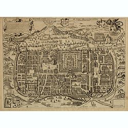
Constantinopolitanae urbis effigies ad vivum expressa.
A rare panoramic town-view of Istanbul with over the whole length of the lower part 3 columns of poems in Latin, Dutch and French and a numbered key 1-29 to the principal...
Date: Amsterdam, 1660
Geographische Beschryvinghe van de wandeling der apostelen ende De Reysen Pauli. . .
In upper and lower part 9 vignettes showing scenes from Paul's wanderings.
- $500 / ≈ €425
Date: Amsterdam, 1660

Xantung, sinarum imperii provincia quatra.
A map of the northern province ‘Xantung’ of China after the Jesuit Martino Martini.Shows the Great Wall and is centered on the Bohai Sea, and the Shandong and Liaonin...
Date: Amsterdam, ca 1660
![[Map of the Holy Land, Israel, and Palestine.]](/uploads/cache/43037-250x250.jpg)
[Map of the Holy Land, Israel, and Palestine.]
A fine example of the six sheet map by Georgius Hornius map of the Holy Land. Each of the maps is embellished with countless vignettes and other images drawn from Biblica...
Date: Amsterdam, Janssonius, 1662

Arabia.
A handsome map of the Arabian Peninsula drawn on a large scale on which the three classical divisions are shown with some urban centers and topographical features. A cert...
Date: Amsterdam, 1662
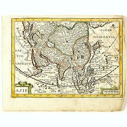
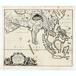
Asie. (8).
Scarce map of Asia published by Antoine de Fer in 1661 or 1662 in "Cartes de géographie revues et augmentées". With number 8 in lower right bottom of the map....
- $200 / ≈ €170
Date: Paris, Antoine de Fer, 1657 but 1661 or 1662
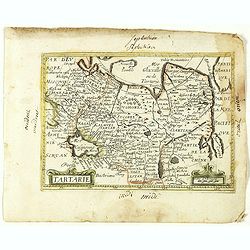
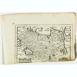
Tartarie. (20).
Scarce map of Tartary published by Antoine de Fer in 1661 or 1662 in "Cartes de géographie revues et augmentées". With number 20 in lower right bottom of the ...
- $100 / ≈ €85
Date: Paris, Antoine de Fer, 1657 but 1661 or 1662
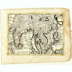
Inde Orientale. (22).
Scarce map of India, the East Indies, Philippines and Malaysia published by Antoine de Fer in 1661 or 1662 in "Cartes de géographie revues et augmentées". Wit...
- $250 / ≈ €212
Date: Paris, Antoine de Fer, 1657 but 1661 or 1662
Geographiae sacrae, ex veteri et novo Testamento desumptae, tabula secunda, in qua Terra promissa, sive Iudaea, in suas tribus partesque distincta . . .
A first edition (dated 1662) of this fine map of the lands described in the Old and New Testament. It provides good detail throughout. Attractive map with decorative cart...
- $100 / ≈ €85
Date: Paris, c. 1662
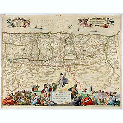
Le Païs de Canaan traversé par notre seigneur Iesus Christ et les apostres.
Fine map of Israel with north oriented to right. Large decorative title cartouche at bottom surrounded by vignettes depicting the life of Christ. At top, putti hold banne...
- $450 / ≈ €382
Date: Amsterdam, 1663
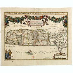
Situs Terrae Promissionis.
Superb map with north oriented to the left. It is finely engraved with numerous biblical scenes including the Exodus, the wandering of the Children of Israel, and several...
- $700 / ≈ €595
Date: Amsterdam, 1665
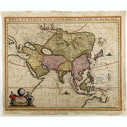
Asiae Nova Apud Hudo Allardt. / Nova et exacta Asiae geograpicha descriptio.
Rare map of Asia, with relief shown pictorially. Shows Great wall of China and the mythical island of Yedso north of Japan. Title at head of map: Nova et exacta Asiae geo...
Date: Amsterdam, 1660-1665
Tabula Geographica Hydrophylacium Asiae Majoris exhibens, quo Omnia Flumina sive proxime sive remote per occultos maeandros Originem suam Sortiuntur.
Rare and Interesting map showing Asia from Arabia in the west until China, Japan, Korea and Philippines with Indonesia. From Kircher's "Mundus Subterranaeus". ...
- $300 / ≈ €255
Date: Amsterdam, 1665

Noordoost Cust van Asia van Japan tot Nova Zembla.
Important for its early depiction of Hokkaido and the Islands to the North of Japan. Ships navigate the seas around the Siberian, Chinese and Japanese coast extending as ...
Date: Amsterdam, 1666

Noordoost Cust van Asia van Japan tot Nova Zemla.
An eye-catching chart of Japan, Hokkaido and the Islands to the North of Japan. In the lower left Korea and part of northern China. Korea has three names mentioned: "...
- $2000 / ≈ €1700
Date: Amsterdam, 1666
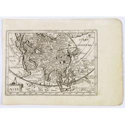
Asie.
This rare map of Asia was published by Jollain in 1667. Published in "Trésor Des Cartes Geographiques Des Principaux Estats de Lunivers".This atlas is based up...
Date: Paris, 1667
Tartarie.
Rare map of Tartary published by Jollain in 1667. In lower right corner Korea as a peninsular and part of America in upper right corner. Published in "Trésor Des Ca...
- $150 / ≈ €127
Date: Paris, 1667
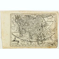
Asie.
Rare map of Asia, published by Jollain in 1667. The name of Korea placed in the sea in between Korea and Japan. In top right part of North America. Published in "Tr�...
- $400 / ≈ €340
Date: Paris, 1667
Le grand Royaume du Sophi de Perse.
Rare map of Persia with present-day Iran and Iraq published by Jollain in 1667. Published in "Trésor Des Cartes Geographiques Des Principaux Estats de Lunivers"...
- $250 / ≈ €212
Date: Paris, 1667
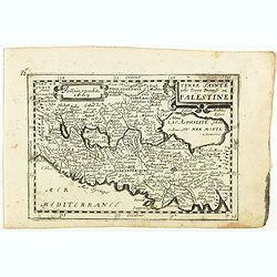
Terre Sainte jadis Terre Promise ou Palestine.
Rare map of the Holy Land published by Jollain in 1667. Published in "Trésor Des Cartes Geographiques Des Principaux Estats de Lunivers".This atlas is based up...
- $300 / ≈ €255
Date: Paris, 1667
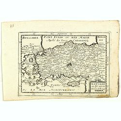
Natolie ou Asie mineur, Lieües d'Alemag.
Rare map of Turkey and Cyprus published by Jollain in 1667. Published in "Trésor Des Cartes Geographiques Des Principaux Estats de Lunivers".This atlas is base...
- $250 / ≈ €212
Date: Paris, 1667

La Chine.
Rare map of China, Korea (as an island) and Japan, published by Jollain in 1667. In upper right corner part of North America. Published in "Trésor Des Cartes Geogra...
- $350 / ≈ €297
Date: Paris, 1667
Turcicum Imperium. Concordia res parvæ crescunt discordia maximæ dilabuntur.
An impressive and attractive map with a particularly fine cartouche showing the Turkish Sultan on his throne and allegorical figures at either side brandishing weapons.Sa...
- $1100 / ≈ €935
Date: Amsterdam, 1667

Impery sino Tartarici Supremus Monarcha.
Decorative costume plate showing Kam Hi son of the Shunzhi Emperor of China [1638 - 1661?], the second emperor of the Manchu Qing dynasty, who apparently supported the fo...
Date: Amsterdam, 1668

Paskaerte Zynde t'Oosterdeel Van Oost Indien, met alle de Eylanden daer ontrendt geleegen van C. Comorin tota aen Iapan.
An eye-catching chart of Pieter Goos' sea chart of Australia, Southeast Asia, China, Japan, Korea and India. The chart shows the regions from Cape Comorin (Southern India...
Date: Amsterdam, 1669

An embassy from the East-India Company of the United Provinces, to the Grand Tartar Cham, Emperor of China deliver'd by their excellencies, Peter de Goyer and Jacob de Keyzer, at his imperial city of Peking. . .
Very rare first English text edition of this most important and early resource on China and the Chinese. Three parts in one folio by John Macock for the author.Part I: An...
Date: London : Printed by the Author at his house in White-Friers, 1669
Jerusalem comme elle estoit du temps que nostre Sauveur Jesus-Christ souffrit mort et passion pour nous.
Rare and decorative view imaginary plan of ancient Jerusalem and its suburbs published by Gérard Jollain after Christian van Adrichom (1533-1595) plan.The plan itself is...
Date: Paris, ca.1670

La Chine d'Athanase Kirchere de la compagnie de Jesus, illustrée de plusieurs monuments tant sacrés que profanes et de quantité de recherches de la nature. . .
Athanasius Kircher, S.J., (1601 or 1602-1680) was a 17th-century German Jesuit scholar who published around 40 works, most notably in the fields of oriental studies, geol...
Date: Amsterdam, 1670
Peking.
Fine panoramic view of Peking. From Olfert Dapper mission to China, 1662-1663. Printed by Jacob van Meurs, title of the book: Gedenckwaerdig bedrijf der Nederlandsche Oos...
- $200 / ≈ €170
Date: Amsterdam, 1670
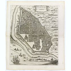
Negapatam.
Bird's-eye view of Nagapattinam or Negapatam, India, printed for the first Dutch edition of Baldaeus' work "A true and exact description of the most celebrated East-...
- $200 / ≈ €170
Date: Amsterdam, 1672
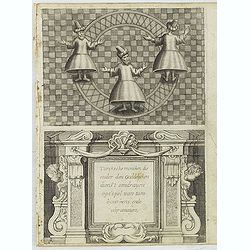
Turckschemoniken die onder den goddelycken. . .
Decorative picture of three dervishes dancers. Their whirling dance, also known as the sema, is a serious religious ritual performed by Muslim priests in a prayer trance ...
Date: Antwerpen, Michiel Cnobbaert, 1673
![[Illustration from Hierusalemsche Reyse.] Interieur of Church of the Holy Sepulchre.](/uploads/cache/30796-250x250.jpg)
[Illustration from Hierusalemsche Reyse.] Interieur of Church of the Holy Sepulchre.
Interior of a Church of the Holy Sepulchre. Below a decorative cartouche with lettered key and surrounded by 2 cherubins.Taken from a very rare travel book by Anthonius G...
- $30 / ≈ €25
Date: Antwerpen, Michiel Cnobbaert, 1673
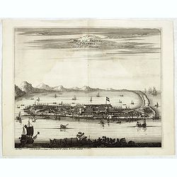
La Ville et le Château de Zélandia dans l' île de Tayovan.
This important copperplate engraving is one of the earliest European views of Taiwan, depicting the Dutch fortifications and trading settlement on the West coast of the i...
- $1800 / ≈ €1530
Date: Amsterdam, 1675
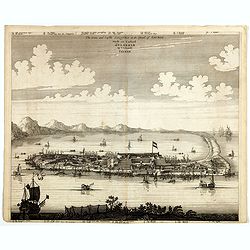
The citie and Castle Zelandia in the Island of Taywan. / Stadt en casteel Zelandia op 't Eilant Taywan.
This important copperplate engraving is one of the earliest European views of Taiwan, depicting the Dutch fortifications and trading settlements on the island's West coas...
Date: Amsterdam, 1675
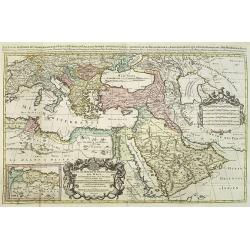
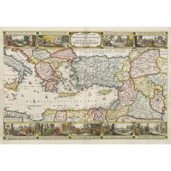
Les Estats De L'Empire Du Grand Seigneur Des Turcs En Europe. . .
Prepared by N.Sanson. The map represents the Ottoman Empire based on Sanson's 1654 map. The Arabian Peninsula is shown with much detail, including towns, villages, mounta...
Date: Paris, 1675
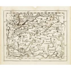
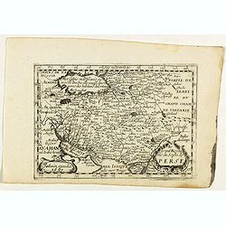
Perse.
Uncommon miniature map of Persia, from Pierre Duval's La Geographie Universeille dated 1676. Following his Cartes de Géographie in 1657, Pierre Duval published this smal...
- $150 / ≈ €127
Date: Paris 1676
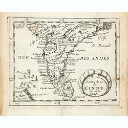
Presqu''isle de L'Inde de ça le Gange.
Uncommon miniature map of India from Pierre Duval's La Geographie Universeille dated 1676. Following his Cartes de geographie in 1657, Pierre Duval published this smaller...
- $150 / ≈ €127
Date: Paris, 1676
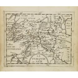
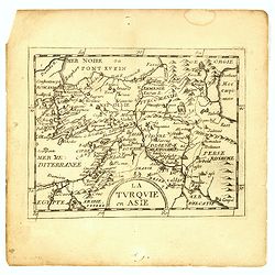
La Turquie en Asie.
Uncommon miniature map of Turkey, Cyprus, Palestine, Armenia, Iran and Iraq. From Pierre Duval's La Geographie Universeille dated 1676. Following his Cartes de geographie...
- $90 / ≈ €76
Date: Paris, 1676
A newe mape of Tartary.
An early edition of one of the most decorative maps of Tartary, known for its figured borders with costume figures, while above are vignettes of the cities of Astrakhan, ...
- $2000 / ≈ €1700
Date: London, 1676
Presqu''isle de L'Inde de ça le Gange.
Uncommon miniature map of India from Pierre Duval's La Geographie Universeille dated 1676. Following his Cartes de geographie in 1657, Pierre Duval published this smaller...
Date: Paris, 1676
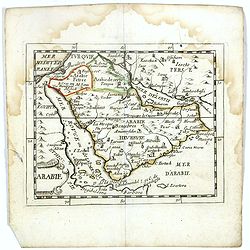
Arabie.
Scarce miniature map of the Arabian peninsular, from Pierre Duval's La Geographie Universeille dated 1676. Following his Cartes de géographie in 1657, Pierre Duval publi...
- $300 / ≈ €255
Date: Paris, 1676
La Turquie en Asie.
Uncommon miniature map of Turkey, Cyprus, Palestine, Iran, Iraq. From Pierre Duval's "La Geographie Universeille" dated 1676. Following his "Cartes de geog...
- $100 / ≈ €85
Date: Paris,1676
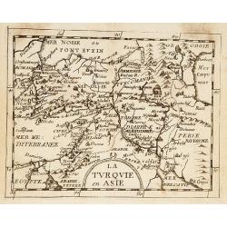
La Turquie en Asie.
Uncommon miniature map of Turkey, Cyprus, Palestine, Iran, and Iraq. From Pierre Duval's "La Geographie Universeille" dated 1676. Following his "Cartes de ...
- $75 / ≈ €64
Date: Paris, 1676
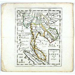
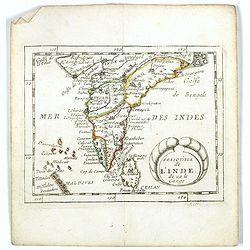
Presqu''isle de LINDE de là le Gange.
Scarce miniature map of Southeast Asia extends from Burma and China in the north to a portion of Sumatra in the south. From Pierre Duval's La Geographie Universeille date...
- $250 / ≈ €212
Date: Paris, 1676