Browse Listings in Asia
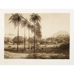
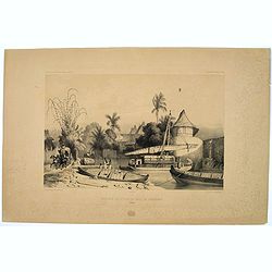
Banjowangui.
Early view of Banjowangui on the island of Java. Engraved in aquatint technique by Sigismond Himely (1801-1872) after Lauvergne. Published as plate 61 in Voyage autour du...
- $150 / ≈ €127
Date: Paris, Finot, 1835
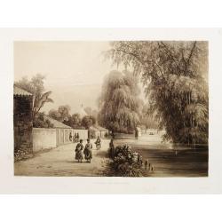
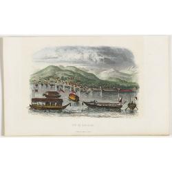
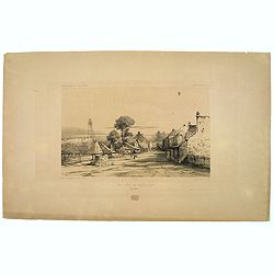
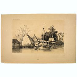
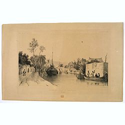
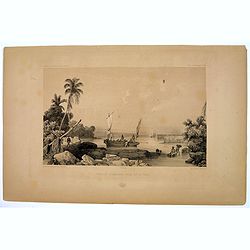
Rivière de Sourabaya.
Early view of Surabaya on the island of Java after Paris and engraved in aquatint technique by Sigismond Himely (1801-1872). Published as plate 61 in Voyage autour du mon...
- $300 / ≈ €255
Date: Paris, Finot, 1835
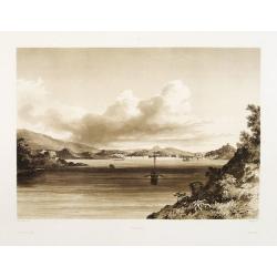
Macao.
Early view of Macao after Barthelemy Lauvergne (1805-1875) and engraved in aquatint technique by Sigismond Himely (1801-1872). Published as plate 28 in Voyage autour du m...
- $600 / ≈ €510
Date: Paris, Finot, 1835

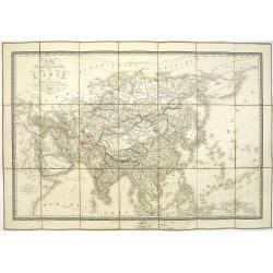
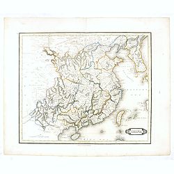
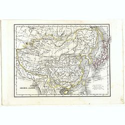
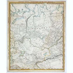
Siberia & Central Asia.
This map covers the eastern section of Russia as well as China, Japan, Korea, India and Tibet. The map is of interest for the use of Sea of Corea, the sea between Korea a...
Date: Boston, 1835
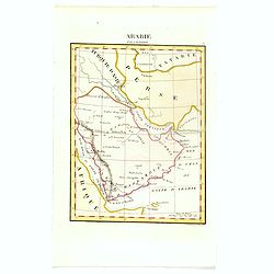
Arabie par A.M. Perrot.
Uncommon map of Arabia, prepared by A.M. Perrot and engraved by P Tardieu.More about Mapping of Arabia [+]
- $100 / ≈ €85
Date: Paris, 1835
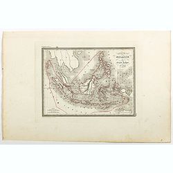
Carte de la Malaisie ou Grand archipel d'Asie.
Nice map of Indonesia, Philippines, Malacca with Singapore and tip of Northern Australia. Engraved by Thierry. Countries and regions in delicate out line color. Includes ...
Date: Paris, 1835
Carte physique et politique de l'Asie. Publiée pour la première fois en 1822 par J. GOUJON. Revue et augmentée par l'éditeur d'après de nouveaux matériaux.
This is a detailed map of Asie. It provides very good details of towns in modern-day Uzbekistan. The region is labeled as "Usbecs." The important cities on the...
Date: Paris, J. Goujon et J. Andriveau, 1837
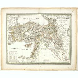
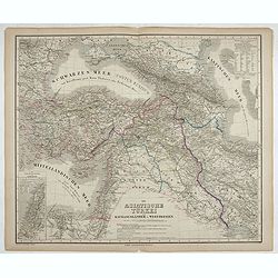
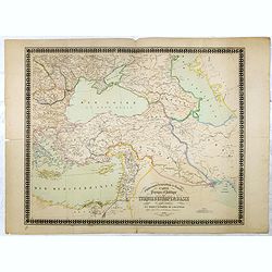
Das Osmanische asien oder die Asiatische Türkey. . .
Decorative map showing 'Asia Minor' with its neighboring countries. Prepared by Karl Ferdinand Weiland The eastern part of the Mediterranean Sea with Cyprus is as well sh...
- $200 / ≈ €170
Date: Weimar, 1836-1838
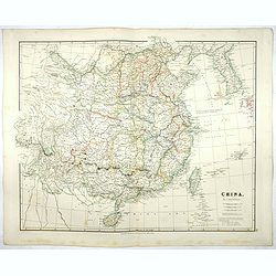
China.
Map of China, Taiwan and Korea. This map by the nephew of Aaron Arrowsmith first appeared in 1832 and was reissued several times. The present issue appeared in Arrowsmith...
Date: London, 1838
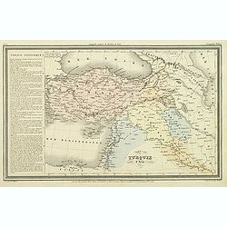
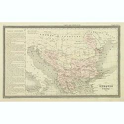
Die Asiatische Türkei. Die Kaukasusländer und West Persien.
Detailed map of Ottoman Asia or the Asian Turkey. Below the title a colored key to Turkish, Iran, Kurd, Caucasus and Russian possessions.Map prepared by H. Kiepert.
- $75 / ≈ €64
Date: Weimar, 1836-1838
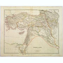
Turkey in Asia.
A lovely looking steel engraved map of Turkey in Asia. Map extent is Asia Minor, Syria, Holy Land, across to the Caucasian peoples that inhabit the lands between the Blac...
Date: London, 1839
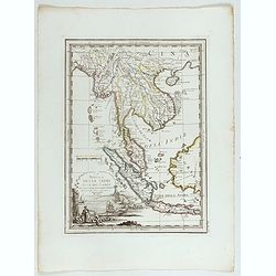
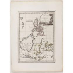
La Penisola delle Indie di la' dal Gange con parte delle Isole della Sonda delineate sulle ultima osservazioni.
Cassini’s splendid early map of Indochina, from Bangladesh in the west to central Borneo in the east, and southern China in the north, to Bali in the south. Good detail...
Date: Rome, Calcography, 1797-before 1839
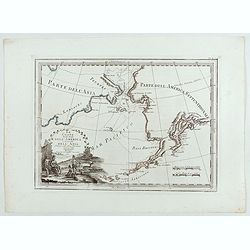
Le Coste Nord Ovest Dell'America e Nord Est dell'Asia Delineate sulle ultime Osservazioni del Cap. Cook
Cassini’s splendid early map of Cook's exploration of the Bering Strait, made on his Third and final voyage. The title is within a decorative title cartouche depicting ...
Date: Rome, Calcography, 1798-before 1839
Le Insole della Sonda
Cassini’s splendid early map of Philippines, and Indonesia..Taken from the ""Nuovo Atlante Geografico Universale delineato sulle ultime osservazioni", pu...
Date: Rome, Calcography, 1797-before 1839
Carte de la Partie Nord-Ouest de' l'Ile de Java. . . Pl. 33. N° 1086.
Sea chart depicting the north west part of the Island of Java, up to Batavia (present-day Jakarta). Also an inset chart of part of the Java coast line.Prepared by Clémen...
Date: Paris, 1839
Turquie d'Asie.
Finely engraved map of Turkey, Cyprus, Palestine, Kurdistan and Iraq, prepared by A.H.Dufour and engraved by Giraldon-Bovinet. Published by Jules Renouard in his uncommon...
- $50 / ≈ €42
Date: Paris, Jules Renouard, ca.1840
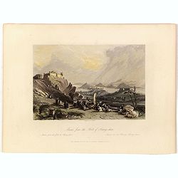
Macao from the Forts of Heang-shan.
A finely delineated view of the city of Macao as seen from one of its fortification areas. The foreground contains a group of religious worshipers. Engraved by S. Fisher....
- $150 / ≈ €127
Date: London, ca. 1840
Carte physique et politique de la Turquie d'Europe et d'Asie contenant la Syrie, une partie de l'Egypte . . .
A detailed map including Turkey, Greece, Black Sea, Holy Land, Georgie, Iran, Iraq, Armenia.
Date: Brussels, 1840
Carte de L'Entrée de la Mer Rouge. Dressée par M.Daussy. . .
Very large and detailed chart depicting the entrance of the Red Sea, including the coastline of Yemen with inset "Carte du détroit de Bab!el-Mandeb. . ." and &...
- $750 / ≈ €637
Date: Paris, ca. 1840
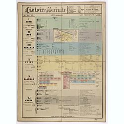
Histoire Sainte, 1840, Cours encyclopédiques - 28e Année - Méthode de Mr Colart . . .
Fine genealogic sheet for educational purpose, about Jewish history. From Adam to Cyrus. In top a map of "Palestine ou Terre Promise en 12 Tribes" 135 x 70mm.
- $350 / ≈ €297
Date: Paris, 1840
Turquie d'Europe.
Finely engraved map of Greece, Bulgaria, Romania, Albania and the east coast of the Black Sea, prepared by A.H.Dufour and engraved by Giraldon-Bovinet. Published by Jules...
Date: Paris, Jules Renouard, ca.1840

Arabia. Sive Regio inter Mare Medium, Arabicum Sinum, . . .
Very detailed map of the Arabian Peninsular, covering the Caspian Sea in the upper right corner and Syria to the Indian Ocean, Somalia and parts of Persia, Syria and Kurd...
Date: London, 1841

Arabia.
Steel engraved map of the Arabian Peninsular. It shows Arabia and Parts of Persia, Syria and Kurdistan. The regional boundaries are colored and relief shown by hachures. ...
Date: London, 1841
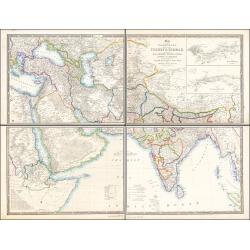
Map of the Countries lying between Turkey & Birmah, Comprising Asia Minor, Persia, India, Egypt & Arabia, and including the Black, Caspian & Red Seas 1841
This striking 4-sheet map, dating to the first half of the 19th century, covers a vast region stretching from Cyprus to Bhutan on the upper sheets and from Egypt to Thai...
Date: London, 1841
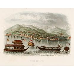
Vue de Nangasaki
View over the town from the water, identifying clearly Deshima with the V.O.C. trading post. Japanese sloops in the fore ground. Engraved by Alp.Boilly.
- $180 / ≈ €153
Date: Paris 1842
Vue de Nangasaki.
Steel engraved of Nagasaki from the water, identifying clearly Deshima, the V.O.C. trading post and the Dutch flag. Japanese and Chinese sloops in the fore ground. Engra...
- $125 / ≈ €106
Date: Paris, 1842
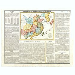
Geographical and Statistical Map of China. China and the Tributary Kingdom of Corea. For the Elucidation of Lavoisne's Genealogical, Historical, Chronological, & Geographical Atlas, by C. Gros, 1820. No. 64. Revised 1828.
Fine map of China and Korea, with a sub-title in top "Geographical and historical map of China.". The map is apparently a revised edition for 1828.The atlas was...
- $450 / ≈ €382
Date: London, 1842
China.
This detailed map of China includes text giving measurements of "The Great Chinese Wall".The map was published in "Lizars' Edinburgh Geographical General A...
- $250 / ≈ €212
Date: Edinburg, 1842
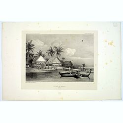
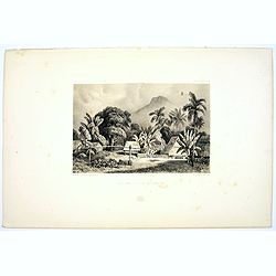
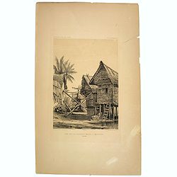
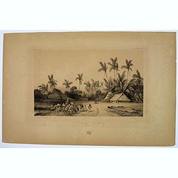
Village de Warrou.
Lithograph of the small settlement of Waru on the island of Seram in Indonesia. Plate 127, taken from the "Voyage au Pole Sud et dans L'Oceanie…." Departing i...
- $50 / ≈ €42
Date: Paris, 1842
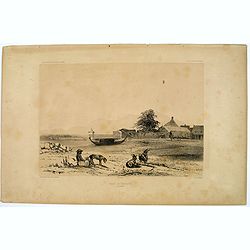
Rade d'Amboine.
A peaceful lithograph of ships and boats at anchor in Ambon Island, located in the archipelago of the Moluccas in Indonesia. Plate 108 taken from the 'Voyage au Pole et d...
- $35 / ≈ €30
Date: Paris, 1842
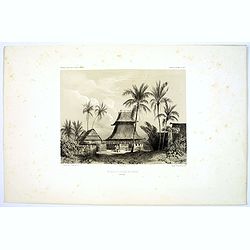
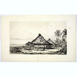
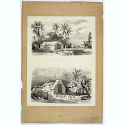
Mosquee du Village de Warou.
A lithograph of the mosque in the village of Waro, on the Indonesian island of Seram. Plate 128 taken from the 'Voyage au Pole et dans L'Oceanie…' Departing in late 183...
- $100 / ≈ €85
Date: Paris, 1842
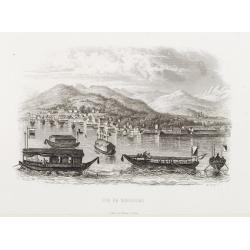
Vue de Nangasaki
View over the town from the water, identifying clearly Deshima with Japanese sloops in the fore ground. Engraved by Alp.Boilly.
- $120 / ≈ €102
Date: Paris, 1842
Rade et Village de Warrou.
An impressive lithograph of the dwellings to be found in the village of Waru, on the Indonesian island of Seram. Plate 126 taken from the 'Voyage au Pole et dans L'Oceani...
- $100 / ≈ €85
Date: Paris, 1842
Site sur la Cote de Sumatra.
A lovely lithograph of a small settlement somewhere along the coast of Sumatra. Plate 154 taken from the 'Voyage au Pole et dans L'Oceanie…' Departing in late 1837 in t...
- $100 / ≈ €85
Date: Paris, 1842
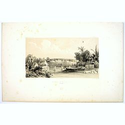
Riviere de Batou-Mera.
A lithograph of a simple bridge crossing the Batou-Mera river on the island of Ambone in the Moluccas, part of the Indonesian archipelago. Plate 110 taken from the 'Voyag...
- $100 / ≈ €85
Date: Paris, 1842
Une rue de Macassar.
A pretty lithograph of a street scene in the village of Makassar, on the southern edge of the Indonesian island of Sulawesi, formerly the Celebes Island. Plate 130 taken ...
- $30 / ≈ €25
Date: Paris, 1842
Une rue du Quartier Malais a Macassar.
An attractive lithograph of the Malay living quarters in the southern village of Makassar in Sulawesi, formerly the Celebes island in Indonesia. Plate 131 taken from the ...
- $30 / ≈ €25
Date: Paris, 1842
Case de Pecheurs dans la riviere Sambas.
A fishing hut seen along the Sambas River in Borneo. Plate 137 taken from the 'Voyage au Pole et dans L'Oceanie…' Departing in late 1837 in the Astrolabe and Zélée, D...
- $30 / ≈ €25
Date: Paris, 1842
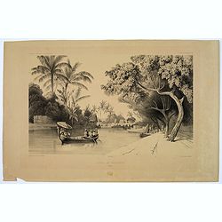
Canal de Samarang.
A tranquil lithograph showing a wealthy man being gently rowed up the canal in Semerang, on the Indonesian island of Java Plate 148 taken from the 'Voyage au Pole et dans...
- $50 / ≈ €42
Date: Paris, 1842
Site sur les bords du canal de Samarang.
A lithograph showing a Canalside scene of activity in the northeastern Javanese city of Semarang. Plate 149 taken from the 'Voyage au Pole et dans L'Oceanie…' Departing...
- $50 / ≈ €42
Date: Paris, 1842
Quartier Malais a Samarang.
A fine lithograph depicting the Malay quarter in the north eastern Javanese city of Semarang in Indonesia. Plate 150 taken from the 'Voyage au Pole et dans L'Oceanie…' ...
- $75 / ≈ €64
Date: Paris, 1842
Aiguade d'Amboine.
Men with barrels in a river on the Indonesian island of Ambone. Plate112 taken from the 'Voyage au Pole et dans L'Oceanie…' Departing in late 1837 in the Astrolabe and ...
- $40 / ≈ €34
Date: Paris, 1842
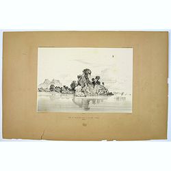
Rade de Ternate.
A peaceful harbour scene on the Moluccan island of Ternate in Eastern Indonesia. Plate 106 taken from the 'Voyage au Pole et dans L'Oceanie…' Departing in late 1837 in ...
- $50 / ≈ €42
Date: Paris, 1842
Entrée du Canal de Samarang.
A lovely lithograph of the canal entrance to the north eastern city of Semarang, on the Indonesian island of Java. Plate 147 taken from the 'Voyage au Pole et dans L'Ocea...
- $50 / ≈ €42
Date: Paris, 1842
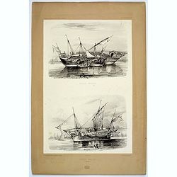
Praos Malais.
A pair of attractive Malay fishing boats. Plate 133 taken from the 'Voyage au Pole et dans L'Oceanie…' Departing in late 1837 in the Astrolabe and Zélée, Dumont D'Urv...
- $50 / ≈ €42
Date: Paris, 1842
Tombeaux Malais pres de Coupang.
A lithograph displaying a pair of funeral monuments of both the Chinese and Malays, on the Indonesian island of Timor. Plate 192 taken from the 'Voyage au Pole et dans L'...
- $30 / ≈ €25
Date: Paris, 1842
Ancien Etablissement Hollandais.
An ancient Dutch settlement in S.E. Asia. Plate123 taken from the 'Voyage au Pole et dans L'Oceanie…' Departing in late 1837 in the Astrolabe and Zélée, Dumont D'Urvi...
- $50 / ≈ €42
Date: Paris, 1842
Aiguade d'Amboine pres de la Mer.
A lithograph of sailors unloading stores from a small sail boat in a tropical bay on the island of Amboina in Indonesia. Plate 112 taken from the 'Voyage au Pole et dans ...
- $50 / ≈ €42
Date: Paris, 1842

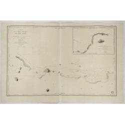
Kaart van de Gaspar Straaten volgens opnemingen van J.Stolze, D.Ross, enz.
Very large and rare chart centered on the strait between Bangka's southeastern seacoast and Belitung's western shores.Short front views of the coastal relief are shown in...
Date: Amsterdam 1843

Straat Riouw onder opzicht van de commissie tot verbetering der Indische Zeekaarten..
Very large and rare so-called Blue Back centered on the strait passing between the Riau Islands. It contains an inset map with enlarged details of Riouw Harbor on Bintang...
Date: Amsterdam 1843
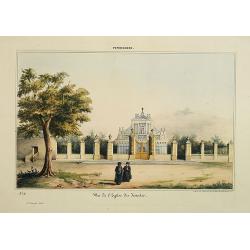
Pondichery - Vue de l'Eglise des Jésuites.
Constructed in 1791, it is regarded as the main mother church of Roman Catholic Archdiocese of Pondicherry and Cuddalore. To one’s surprise, this famous church in Pondi...
- $300 / ≈ €255
Date: Paris, 1843
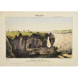
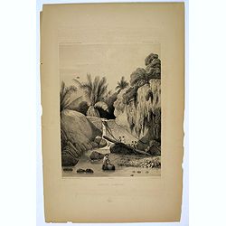
Southern - Concan.. - Nalkind or Kates Point..
Lithography representing a rocky landscape in the Western Ghats. Plate N° 12. From Souvenirs d'un voyage dans l'Inde, exécuté de 1834 à 1839, by A. Delessert.Adolphe ...
- $300 / ≈ €255
Date: Paris, 1843
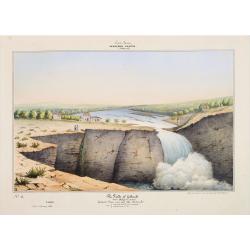
Southern - Concan.. - The falls of Gokank..
Hand colored lithography representing a view of the Gokak Falls, located on the Ghataprabha River. The Ghataprabha river in India is an important right-bank tributary of ...
Date: Paris, 1843

Kaart van een gedeelte van de Noord Kust van Java en Straat Sunda van Tanjong Kaik tot den vierden hoek bij Anjer..
Very large and rare chart depicting Java's northern seacoast.Coastal profiles are present at the bottom of the map.The chart is prepared by B.H.Staring, J.A.G.Rietveld an...
Date: Amsterdam 1843-1844
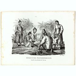
Koreische Fischerfamilie. Famille de pecheurs de Corea.
A Korean family of fishermen playing a board game. No.9' above image. From "Schinz Naturgeschichte und Abbildungen des Menschen der verschiedenen Rassen und Stämme&...
Date: Zürich, 1845
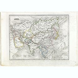
Asie.
Detailed map of Asia, prepared by Charles V. Monin (fl.1830-1880) a French cartographer of Caen and Paris. Published in Atlas Universel de Géographie Ancienne &c Mod...
- $50 / ≈ €42
Date: Paris, 1845
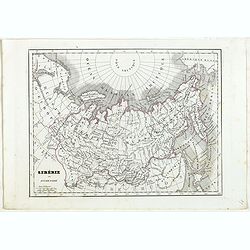
Sibérie ou Russie d'Asie.
Detailed map of Siberia, prepared by Charles V. Monin (fl.1830-1880) a French cartographer of Caen and Paris. Published in Atlas Universel de Géographie Ancienne &c ...
- $40 / ≈ €34
Date: Paris, 1845
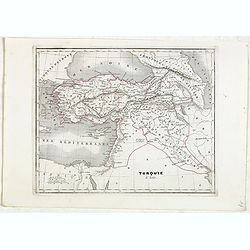
Turquie d'Asie.
Detailed map of Asian Turkey with Cyprus, prepared by Charles V. Monin (fl.1830-1880) a French cartographer of Caen and Paris. Published in Atlas Universel de Géographie...
- $45 / ≈ €38
Date: Paris, 1845
Chine et Japon.
Detailed map of China, Korea, Taiwan and Japan, prepared by Charles V. Monin (fl.1830-1880) a French cartographer of Caen and Paris. Published in Atlas Universel de Géog...
- $75 / ≈ €64
Date: Paris, 1845
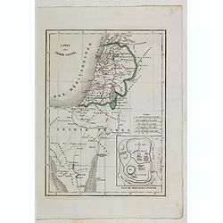
Carte de la Terre Sainte.
Detailed map of Israel, prepared by Charles V. Monin (fl.1830-1880) a French cartographer of Caen and Paris. Published in Atlas Universel de Géographie Ancienne &c M...
- $25 / ≈ €21
Date: Paris, 1845
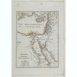
Egypte, Palestine, Syrie et Phoenicie.
Detailed map of Egypt, Palestine, Syria and Phoenicia, prepared by Charles V. Monin (fl.1830-1880) a French cartographer of Caen and Paris. Published in Atlas Universel d...
- $25 / ≈ €21
Date: Paris, 1845

Straat Sunda en Westkust van Java.
Very large and rare chart depicting Java's western seacoast close to the Sunda Strait.Showing part of Sumatra on top and the West Java tip, today hosting the Ujung Kulon ...
Date: Amsterdam (1841)1846
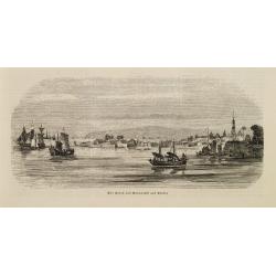
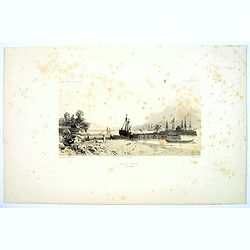
Der Hafen von Nangasaki auf Kiusiu.
A panoramic view of the harbour and city of Nagasaki with extensive shipping.
- $100 / ≈ €85
Date: Germany, 1847

Kaart van de Reede van Batavia met de verschillende vaarwaters naar dezelve trigometrisch opgenomen op last van deb schout bijnacht E.Lucas.
Very large and rare so-called blue-black chart centered on Jakarta's harbor.The chart is prepared by B.G.Escher, I.A.C. Eschauzier, B.H.Staring and E.H.Boom during an exp...
Date: Amsterdam (1841) 1847
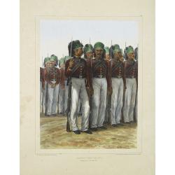
Infanterie Turque (chasseurs). 7 novembre 1837.
Beautiful lithography by Auguste Raffet (1804 -1860 ) and printed by Auguste Bry.
Date: Paris, Gihaut frères, 1848

ARMENIEN. Costumes de l'Empire Ottoman 9.
A beautiful hand colored lithograph of an Armenian published in the French work "Galerie Royale de Costumes peints d´après nature par divers artistes et lithograph...
Date: Paris, Chez Aubert & Cie., 1842-1848
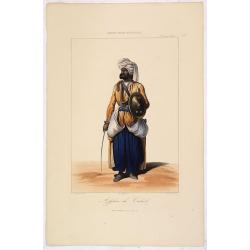
AFGHAN de CABOULE. Costumes Persans 8.
A beautiful hand colored lithograph of an elegant Afghan from Kabul published in the French work "Galerie Royale de Costumes peints d´après nature par divers artis...
Date: Paris, Chez Aubert & Cie., 1842-1848

DANSEUSE. Costumes Persans 9.
A beautiful hand colored lithograph of an elegant dancing girl from Persia published in the French work "Galerie Royale de Costumes peints d´après nature par diver...
Date: Paris, Chez Aubert & Cie., 1842-1848

FEMME DE NAZARETH (Palestine). Costumes Syriens 10.
A beautiful hand colored lithograph of a woman from Nazareth (Palestine) published in the French work "Galerie Royale de Costumes peints d´après nature par divers ...
- $300 / ≈ €255
Date: Paris, Chez Aubert & Cie., 1842-1848
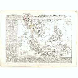
Malesia ossia Arcipelago Indiano, ed India-Transgangetica.
Attractive map of the Southeast Asia by a cartographer from Naples, listing his cartographic sources and giving political and statistical information on the areas covered...
- $500 / ≈ €425
Date: Naples, 1848
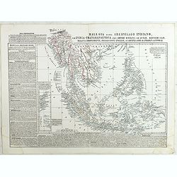
Malesia ossia Arcipelago Indiano, ed India-Transgangetica . . .
Attractive map of the Southeast Asia by a cartographer from Naples, listing his cartographic sources and giving political and statistical information on the areas covered...
Date: Naples, 1848
Western siberia, independent tartary, khiva, bokhara.....
This map was originally published by The Society for the Diffusion of Useful Knowledge in 1838, this date is printed on the map. This edition of the map was printed and p...
- $75 / ≈ €64
Date: London, 1848
Carte des Détroits Singapore, Durain..
An exceptionally rare nautical chart of Singapore and direct vicinity issued by Urban Dortet de Tessan, under the patronage of Louis Philippe I of France. When Singapore...
Date: Paris, 1848
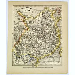
China-Propria oder das eigentliche China.
Map number 48 from Meyer's 'Zeitung's Atlas', a popular German 'pocket atlas', published during the mid nineteenth century. This map of China shows the mainland, and the ...
Date: Hildburghausen / Philadelphia, 1849
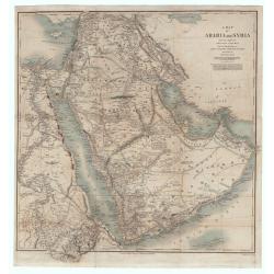
A Map of Arabia and Syria Laid Down Chiefly From Original Surveys Under the Superintendence of Lieut. Colonel Chesney, R.A.F.R.S. and drawn by W. H. Plate. L.L. D
This is one of the most significant and detailed maps of Arabia and the Persian Gulf. It is drawn by Plate using various sources. As stated below the cartouche the source...
Date: London, 1849
Der Hafen und die Bai von Nagasaki.
A bird's-eye view showing Deshima and Nagasaki Bay with Dutch ships and two Dutch flags on Deshima.
- $250 / ≈ €212
Date: Germany, 1850
![[7 Indian Patna water colors of crafts.]](/uploads/cache/43663-250x250.jpg)
[7 Indian Patna water colors of crafts.]
Seven Company school, also called Patna painting, style of miniature painting that developed in India in the second half of the 18th century in response to the tastes of ...
- $750 / ≈ €637
Date: India, ca.1850
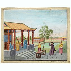
Chinese Export watercolor.
Chinese watercolor with in lower margin Chinese text : Chinese watercolor - " A farmer's thief, a book, a big manuscipt, a filial piety, a martial art. " [Googl...
- $1000 / ≈ €850
Date: China, ca. 1850
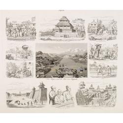
A rare and impressive pictorial Qing Empire map of the western part of Taiwan.
The top of the map faces east, the bottom faces west, and the left and right are north-south. It is about 120 cm high and 225 cm long. The map shows only to the west of t...
Date: ca. 1850
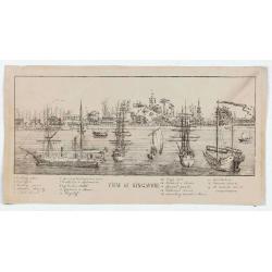
View of Singapore
Very rare view of Singapore from the Singapore River Basin. With a numbered key (1-19) underneath the illustration. In the center Government Hill with Governer's House (1...
Date: ca. 1850