Browse Listings

Ce que les Anglo-Saxons ont perdu en Extrême-Orient.
Illustrated Vichy propaganda War & Propaganda poster showing a map of South East Asia, with Indonesia, Philippines, Thailand, etc., among photos and explanations abou...
Date: Paris, 1943

Carte de la Charte de L'Antique . . .
The rare French version of this decorative pictorial world map by MacDonald Gill. "This magnificent map drawn up while the Second World War still raged is already en...
Date: London, Alf Cooke Ltd, 1943

Untitled wartime propaganda map poster depicting Roosevelt & Churchill struggling between each other over the African Continent.
This powerful image shows US President Franklin D. Roosevelt and UK Prime Minister Winston Churchill in a tug-of-war over Africa. This original war poster was created by ...
Date: Paris, Bedos et Cie, 1942-1943

Group of 21 watercolors of scenes in Iceland, included are vulcanos like Eyjafjallajokull, Öræfajökull, etc.
A group of water colors made during visits of the artist F. de Boungne to Iceland, among them are contemporary artistic impressions of the now world-famous volcano Eyjafj...
Date: Iceland, 1933-1944
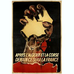
Après l'Algérie et la Corse Demain se sera la France.
Anti-Communist propaganda poster, realised by the French Vichy Government and the Germans in January 1944. Propaganda hostile to the liberators playing on the fears of th...
Date: Paris, 1944

Indie moet vrij vecht ervoor.
War propaganda poster by Patrick (Pat) Cokayne Keely, distributed in the liberated South of the Netherlands, this poster concerned the Japanese occupation of Indonesia an...
Date: London, J.Haworth / Brother Ltd, 1944

ADSEC in Action from Thames to Rhine.
A pictorial map showing the allied movement from London on 14 March 1944 thru the conquest of Germany. Showing the track from London along Bristol, crossing the British C...
Date: London, 1945
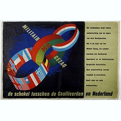
MG Militair Gezag. De schakel tusschen de Geallieerden en Nederland.
Poster on the Allied military cooperation published by the Dutch Military Government. The poster has three colorful linked rings against a dark black and blue background....
Date: London, James Haworth & Brother LTD, 1944 - 1945
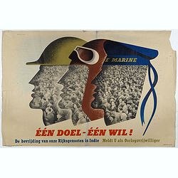
Één doel - Één wil. (Koninklijke Marine)
Poster on the Allied military cooperation published by the Dutch Military Government. ¨Poster with stylised portraits of an infantryman, airman and sailor, turned in pro...
Date: London, James Haworth & Brother LTD, 1944 - 1945
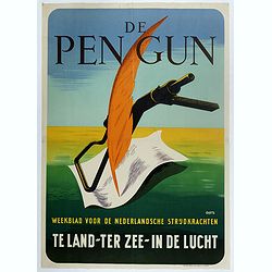
De Pen Gun Weekblad voor de Nederlandsche Strijdkrachten.
Poster designed by Willem Anthonie Oepts (1904 - 1988), published by the Dutch Military Government for "De Pen gun".The designer Willem Anthonie Oepts (1904 - 1...
Date: Weert, Smeets, 1945

San Diego Bay. (Chart 5107)
Nautical chart of San Diego Bay of 1945. Printed in black, yellow and purple the "Seaward limit defensive sea area". The water area within the indicated limits ...
Date: Washington, 1945
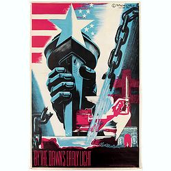
By the Dawn's Early Light.
Original 1940's WW II American liberation poster by Natacha Carlu, published by the French Press & Information Service, New York, N. Y.The poster shows a torch-bearin...
Date: New York, French press and information service, 1945
![Mapa geral do Brasil / organizado pelos J. Carneiro da Silva e Pedro Voss. [Together with] Micro geografia do Brasil. [Together with] Pequeno Mapa do Brasil.](/uploads/cache/45466-250x250.jpg)
Mapa geral do Brasil / organizado pelos J. Carneiro da Silva e Pedro Voss. [Together with] Micro geografia do Brasil. [Together with] Pequeno Mapa do Brasil.
Large folding national map published by "Comp. Melhoramentos de São Paulo Industrias de Papel". Nova edicao revista 1946. Figures for all states. "Futuro ...
Date: São Paulo, 1946
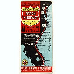
New York - Miami Ocean Highway. Pines to Palms. - Ocean Highway Official Highway Route Approved and Sponsored by the Ocean Highway Association.
Vintage road map showing "The Route of the Experience Motorist" features mileage information in the right margin. Verso features information on cities along the...
Date: Washington, ca. 1947

Langwasser Stanislau Neu Brandenburg Mei 1942 Juni 1945
Map met reproducties van crayontekeningen van Krijgsgevangenschap in Langwasser, Stanislau en Neu-Brandenburg, Mei 1942 -juni 1945.Uitgegeven april 1948 door het Minister...
Date: Den Haag, April 1948

A Hysterical Map Of Death Valley National Monument -- And It's Looking Mighty Low
First edition Humorous map of Death Valley. "Drawn In Broken English by Jolly Lindgren," this comic pictorial map is full of puns and comic vignettes related to...
Date: Spokane, Wash., Lindgren Brothers, 1948

Kaart van Palestina voor oud- en nieuw testament behorend bij de weg met en naar Christus door Fr. M. Bellarminus.
Original vintage illustrated map wall map sized poster (166 x 118cm) of Palestine in the time of Christ featuring a map of the old and new testament of the Bible from The...
Date: Utrecht, Sint Gregoriushuis, 1948

Du sang à l'aube.
Original lithographed poster for the Spanish movie "Blood at dawn" (1948) directed by Rafael Gil, based on the novel by Blasco Ibanez. Poster designed by Duccio...
Date: Paris, 1948

Plan commercial de la Région Saïgon-Cholon.
Decorative publicity plan of Ho Chi Minh City, also known by its former name of Saigon and Cholon, prepared by Ngo-Trinh, surrounded by advertisements of local stores. Th...
Date: Saigon, 1948

Key Map of Hong Kong Relative to Canton and Macao.
A nice folded map of Hong Kong and the surrounding areas. Produced by the British Crown Lands Survey Office just after WWII. Physical features are shown by contour. Railw...
Date: Hong Kong, 1948

Coast to Coast.
A game board that features a map of the U.S. with a built-in spinner. Players travel a circular track around the map visiting landmarks as they go. A fun way to learn geo...
Date: New York, ca. 1950
Ride the Roads to Romance along the Golden Coast and thru the Sunshine Empire of Southern California.
Published in 1950 by the Roads to Romance Association to promote tourism in California This striking touring map of Southern California was published in 1950 by the Ro...
Date: California, 1950
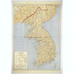
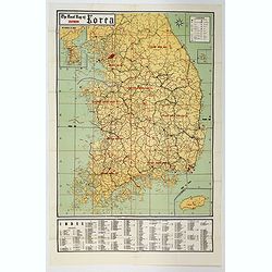
Official War map of Korea.
A large folding map of Korea published in the year of the outbreak of the Korean War, published by the Rand McNally Company. The map is extremely detailed and features a ...
Date: America, ca 1950
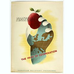
Prosperity - The Fruit of Cooperation.
NATO poster for European Cooperation by Brian E. Dear. On the poster the slogan "Prosperity the fruit of cooperation". The poster is showing a hand holding an a...
Date: Kühn & Zoon Rotterdam, 1950

FN HJAELP (Help).
Danish poster depicting a child sitting on a globe, threatened by a black snake. Designed by Aage Sikker Hansen and printed Andreasen & Lachmann in Copenhagen, Denmar...
Date: Copenhagen, ca. 1950
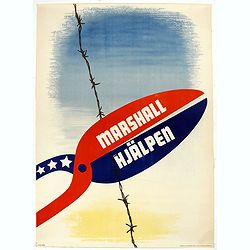
Marshall Hjälpen.
Marshall Plan poster made by Gusta Aberg, showing barbed wire cut by pliers with slogan on pliers: Marshall Hjälpen This is one of the 25 finalists in the 1950 “Intra-...
Date: Kühn & Zoon Rotterdam, 1950
Souvenir Guide Map of Cairo.
A lovely small colored plan of central Cairo, published by Groppi in Cairo. Plan is housed within the original red and gold printed paper covers, with advertisements for ...
Date: Cairo, 1920-1950
![[Planisphère] - Crédit Lyonnais - Fondé en 1863. Afrique du Nord à Union Française.](/uploads/cache/44865-250x250.jpg)
[Planisphère] - Crédit Lyonnais - Fondé en 1863. Afrique du Nord à Union Française.
Original pictorial lithographed advertising poster showing the western part of Africa. Published by the French bank Crédit Lyonnais.Design by Lucien_Boucher who is a fam...
Date: Paris, 1950
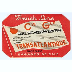
French Line First Class Bagages de Cale.
French Line First Class Bagages de Cale sticker for the journey Havre- Southhamptons New-York. It used to be stuck on luggage. The Compagnie Générale Transatlantique is...
Date: Paris, ca. 1950
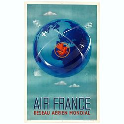
Réseau aérien mondial.
"Sur les ailes d'Air France, découvrez le monde à votre tour" lithograph poster from AIR France. A great mid-century design by Air France advertising poster b...
Date: Imprimerie Perceval Paris, ca. 1940-1950
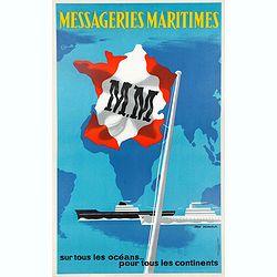
Messageries Maritimes, sur tous les océans, pour tous les continents.
Original lithographed poster from the 1950s by Jean Desaleux. The poster has a blue background and a map of the continents and oceans. France is in the colors of the Mari...
Date: Paris, ca. 1950
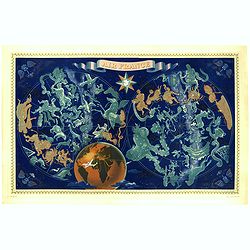
AIR France - Réseau Aérien Mondial.
Original pictorial lithograph advertising planisphere poster from AIR France. The poster has a black background. In the lower right below the border '016/P/AF Printed in ...
Date: Imprimerie Perceval, Paris, ca. 1950
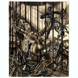
Tiger tamer.
Showing a tiger tamer with two tigers who apparently have more interest in his erotic, scarily dressed assistance.
Date: ca. 1950
![[Untitled cartoon in pencil.]](/uploads/cache/46791-250x250.jpg)
[Untitled cartoon in pencil.]
A pharmacy cartoon in French, drawn probably in the first half of the last century. It depicts a pharmacist giving some advice to another, seen crushing a powder with a p...
Date: French, ca. 1950
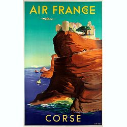
Air France - Corse.
Corsica poster for Air France, by Raoul Éric Castel (1915 - 1997) and published by Havas. Signed has work with Éric, he was born in Lyon and made many fine travel poste...
Date: Imprimerie Perceval Paris, ca. 1940-1950
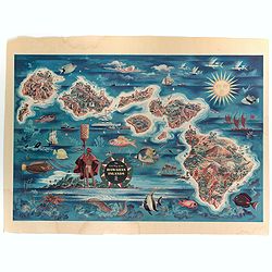
The Dole Map of the Hawaiian Islands.
A terrific, colorful poster of the Hawaiian Islands by Joseph Feher, commissioned for the Hawaiian Pineaple Co. The poster displays all eight of the major islands in the ...
Date: USA, 1950
![Les Forbans [Board game]](/uploads/cache/49165-250x250.jpg)
Les Forbans [Board game]
Game board designed by Lucien Boucher, without any randomness, which is rare for that time. The board which is cut in four parts show a world map drawn by Lucien Boucher....
Date: Paris, Perceval, ca. 1950
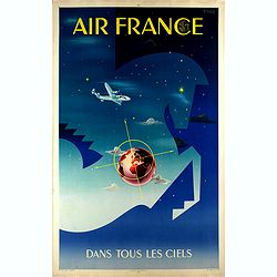
Air France dans tous les ciels.
Original lithograph advertising poster for Air France, by Badia Vilato Xavier. Signed in the upper right corner. The poster has always occupied a special place in Air Fra...
Date: Imprimerie Perceval, Paris, 1951

A map of the British Army with battle honours and militray achievements and Regimental Badges . . .
Shows English County Regiments, Battle Honours and Military Achievements. Bordered by Regimental Badges.A fascinating piece of British history.Read more about Pictorial M...
Date: London, 1952
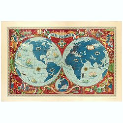
AIR France - Sur les ailes d'Air France découvrez le monde à votre tour.
Promotional poster of a double hemisphere world map designed by Lucien Boucher for AIR France. The map depicts the entire world in rich blues and burgundies with gold hig...
Date: Perceval, Paris, 1952
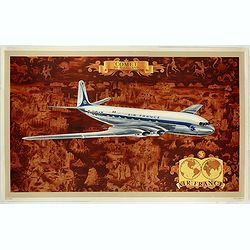
AIR France - Comet De Havilland
Promotional poster attributed to Lucien Boucher showing the Comet de Havilland on a Mercator projection world map. The map depicts a pictorial map of the entire world in ...
Date: Perceval, Paris, 1953
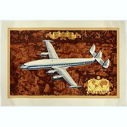
AIR France - Super constellation, Lockhead L - 10 - 49.
Promotional poster attributed to Lucien Boucher showing of a Lockhead L - 10 - 49 on a Mercator projection world map. The map depicts a pictorial map of the entire world ...
Date: Perceval, Paris, 1953
Pacific Stars and Strips Map of the War.
A detailed map of the Korean War. Several silhouetted flying military aircraft are shown in formation. The map shows the Korean Peninsula from its northern border with Ru...
Date: America, 1953
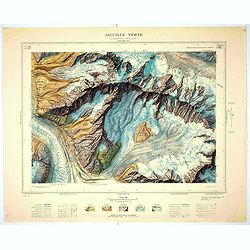
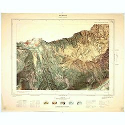
Aiguille verte - Chamonix N°6 Sud
Magnificent 1:10,000 scale color printed map of l'Aiguille verte (Chamonix N°6 Sud) based on stereotopographic ground and aerial surveys carried out in the field in 1950...
Date: Paris, 1953
Servoz - Cluses N°8 Sud.
Magnificent 1:10,000 scale color printed map of Servoz (Cluses N°8 Sud) based on stereotopographic ground and aerial surveys carried out in the field in 1950 and render...
Date: Paris, 1953
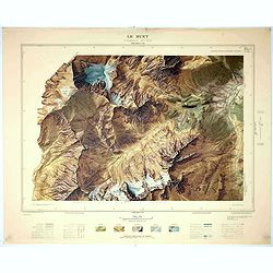
Le Buet - Chamonix N°1 Sud. / Massif des Aiguillles Rouges.
Magnificent 1:10,000 scale color printed map of Le Buet (Chamonix No. 1 South) / "Massif des Aiguilles Rouges" based on stereotopographic ground and aerial surv...
Date: Paris, 1953
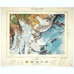
Aiguille du Midi - Mont Blanc N°1 Nord.
Magnificent 1:10,000 scale color printed map of L'Aiguille du Midi (Mont Blanc N°1 Nord) based on stereotopographic ground and aerial surveys carried out in the field in...
Date: Paris, 1953
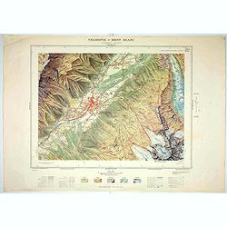
Chamonix - Mont Blanc - Chamonix N°5 Sud.
Magnificent 1:10,000 scale color printed map of Chamonix - Mont Blanc (Chamonix N°5 Sud) based on stereotopographic ground and aerial surveys carried out in the field in...
Date: Paris, 1953

(World map). Americus Vespucio novo te Duce Ducta Freto Ambivi Meritoqs Vocor.
Manuscript world map showing the American and African continent and the southern parts of Asia. In the Indian Ocean a large depiction of Amerigo Vespucci 1454 – 1512) o...
Date: Italy, ca. 1954
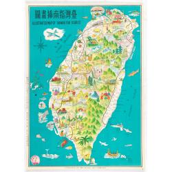
Illustrated map of Taiwan for tourist.
illustrated map of Taiwan for tourist. Pictorial map of Formosa published by Mei Kuang Art Company. Printed in English and Chinese. Features remarkable sites, various agr...
Date: Mei Kuang Art Company, 1954
![Air France [poster].](/uploads/cache/44299-250x250.jpg)
Air France [poster].
A superb double-sided Air France folding poster, featuring bold colored graphics. Published as a serious piece of marketing put out by the airline showing off their state...
Date: Paris, 1955
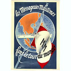
Les Messageries Maritimes font le tour du monde.
Original lithographed mini poster (570 x 400mm.) created by the artist Robert Louis Antral for Les Messageries Maritimes, showing a boat and a globe. Les Messageries Mari...
Date: Paris, 1955

Indonesia.
Original vintage travel advertising issued by the Indonesian Council for Tourism featuring a colorful pictorial map marking the islands and oceans with images of local pe...
Date: Jakarta, ca. 1955
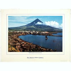
Philippines - The famous volcanic peak Mt. Mayon. . .
Mt Mayon Volcano Peak near Legaspi on the Philippines. Fine Pan American Airline mini poster.Pan American World Airways, originally founded as Pan American Airways and co...
Date: 1956
Selling price: ????
Please login to see price!
Sold in 2023
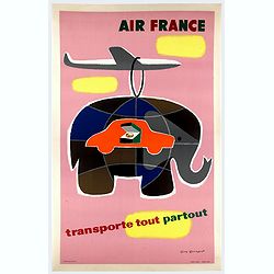
Air France transporte tout partout.
Nice poster designed by Guy Georget, promoting the freight service of Air France.Guy Georget (1911-1992), was a French poster designer and illustrator. Georget's first co...
Date: Perceval, Paris, 1958

AIR France - Le plus grand réseau du monde.
Created in 1959 by the artist Lucien Boucher, showing all of the DC-7 Air France Routes. The Blue Pink Poster is one of a series of eight posters commissioned by Air Fran...
Date: Imprimerie Perceval, Paris, 1959

Forteresse Ile Ste Marguerite.
Nice drawing of a stronghold Ste Marguerite. The Île Sainte-Marguerite is the largest of the Lérins Islands, about half a mile off shore from the French Riviera town of...
Date: France, Provence, after 1960
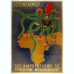
Ses Amputations se Poursuivent Methodiquement.
Propaganda map, produced under the NAZI collaborating Vichy French regime and designed to inspire revulsion and hatred of the English among the French, while frequently d...
Date: Paris, ca. 1941 / ca. 1960
The Road Map of Southern Korea.
Offset printing. A large scale, comprehensive road map of South Korea, with a symbol legend and an inset map of 'The Republic of Korea', and inset of the island of Jeju D...
Date: Seoul, ca 1960
![[TAI travel poster]](/uploads/cache/44304-250x250.jpg)
[TAI travel poster]
A whimsical travel poster for "Transport Aeriens Intercontinentaux" (TAI), published in Paris in 1960, by Luc-Marie Bayle (1914-2000). The poster depicts a twin...
Date: Paris, 1960
![[Fan shaped shopping guide to Stockholm.]](/uploads/cache/44788-250x250.jpg)
[Fan shaped shopping guide to Stockholm.]
A highly unusual and interesting vintage fan-shaped map of Stockholm to illustrate a 'Shopping guide to Stockholm'. Text written in English. With ten fold-out panels prin...
Date: Stockholm, 1960
![[TAI travel poster]](/uploads/cache/44894-250x250.jpg)
[TAI travel poster]
A whimsical travel poster for "Transport Aeriens Intercontinentaux" (TAI), published in Paris in 1960, design by François Lesourt (Périgueux, 1913 - 1997). Th...
Date: Paris, Hubert Baille & Cie Paris, 1960
![[No title] Gouache of a class scene with globe, revolting students and a teacher.](/uploads/cache/44404-250x250.jpg)
[No title] Gouache of a class scene with globe, revolting students and a teacher.
Gouache of a class scene with a globe centered on Europe and Africa with revolting students and a teacher. Original design for a pulp publication.
Date: ca. 1950-1960
![[Pictorial map of Georgia (Caucasus)].](/uploads/cache/47135-250x250.jpg)
[Pictorial map of Georgia (Caucasus)].
A scarce pictorial map of a region in Georgia in the Caucasus. Map is entirely in Russian, complete with legend at base of map, with small thumbnail pictures and symbols ...
Date: Moscow, 1963
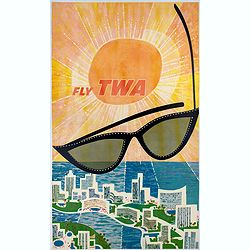
Fly TWA (Miami).
This Miami poster was created in the early 1960's by David Klein (1918 -2005) for TWA. It depicts “hotel row” along Collins Avenue leading to the corridor of South Be...
Date: 1965
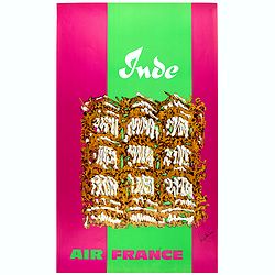
Inde.
Decorative poster advertising flights to India made by Georges Mathieu. The poster is one of a series of 15 composed of posters of Greece, Israel, Germany, Great Britain,...
Date: Paris, 1967

Japan (poster signed by Georges Mathieu)
Dedicated "Pour Benijs Boulanger" and signed "Georges Mathieu", in black marker. Decorative poster advertising flights to Japan made by Georges Mathie...
Date: Paris, 1967
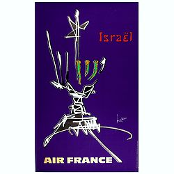
Israel.
Decorative poster advertising flights to Israel made by Georges Mathieu. The poster is one of a series of 15 posters of Greece, Israel, Germany, Great Britain, Canada, Eg...
Date: Paris, 1967
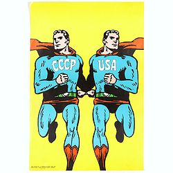
CCCP/USA, 1966
Original 1968 Cold War Superman Style Poster by Roman Cieslewicz (1930-1996). Published by Georges Fall, Paris. Printed by Serg, Paris.In 1968 the Parisian left-wing ar...
Date: Serg, Paris, 1968
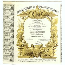
Compania General De Tabacos De Filipinas - (Certificate) Accion ordinarias de 500 Pesetas, Barcelona, 27.10.1969.
Beautifully engraved certificate from the Compania General De Tabacos De Filipinas issued in 1985. This historic document has an ornate border around it with a vignette o...
Date: Barcelona, 1969

Sabena (USA - NYC).
Sabena Belgian World Airlines poster showing the skyline of New York in abstract style. Published by Rali Brisart in Belgium.La Sabena, acronym for Societé Anonyme Belg...
Date: Brussels, ca. 1970
![[Chinese propaganda poster]. We Shall Liberate Taiwan !](/uploads/cache/49024-250x250.jpg)
[Chinese propaganda poster]. We Shall Liberate Taiwan !
Chinese propaganda poster : "We Shall Liberate Taiwan!", by the Hongyingbi (Red Eagle Brush) unit of the Air Force Unit of Nanjing Military Region.The Chinese d...
Date: China, 1971
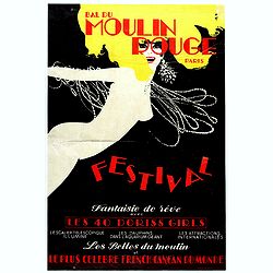
Bal du Moulin Rouge Paris - Femmes Femmes Femmes.
Poster designed by René Gruau for Bal du Moulin Rouge Paris - Festival fantaisie de rêve avec les 40 Doris Girls. Signed in the upper right-hand corner with Monogram G....
Date: Paris, Artis SA Paris, 1973
![[Anti capitalism Soviet Union propaganda poster]](/uploads/cache/47032-250x250.jpg)
[Anti capitalism Soviet Union propaganda poster]
Propaganda mini anti-capitalism poster published in Russia during The Cold War. By the 1960’s and 1970’s, outrageous practices in Soviet bureaucracy flourished. Poor ...
Date: Leningrad, 1974
![[Anti capitalism Soviet Union propaganda poster]](/uploads/cache/47035-250x250.jpg)
[Anti capitalism Soviet Union propaganda poster]
Propaganda mini anti-capitalism poster published in Russia during The Cold War. By the 1960’s and 1970’s, outrageous practices in Soviet bureaucracy flourished. Poor ...
Date: Leningrad, 1974
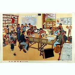
Large 13-person library (from Huxian Farmers' painting Exhibition)
A library with students with a western world map at the wall. Published by Shanghai renmin chubanshe (上海人民出...
Date: Shanghai, September, 1974 / Janury 1975
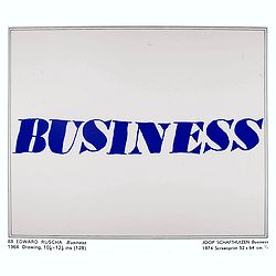
Kunst is allemaal flauwe kul.
Joop Schafthuizen is a Dutch artist known for his prints. He inspired some of the books written by his partner, the famous writer Gerard Reve. "Kunst is allemaal fla...
Date: Rotterdam, 1976
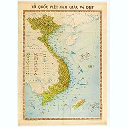
To Quoc Viet Nam Giau Va Dep (Vietnam).
Economic map of Vietnam published in 1976.Features Vietnam, Cambodia, Laos and part of Thailand. With a key referring to agricultural productions and fauna…The map show...
Date: Hanoï, 1976
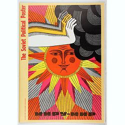
The Soviet Political Poster. - a portfolio collection of 32, full-color posters.
An attractive large portfolio set of 32 reproductions published in Leningrad in 1976 by Aurora Art Publishers, containing various Soviet Union political posters from 1919...
Date: Leningrad, Aurora Art Publishers, 1976
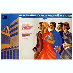
Нам знания станут опорой в труде (= Nam znaniia stanut oporoi v trude = Knowledge will become a support in our workforce).
Original vintage Soviet motivational poster by Y. Tupitsyn, with in top Нам знания станут опорой в труде (= Nam znaniia stanut oporoi v trude) ...
Date: Moscow, 1977
