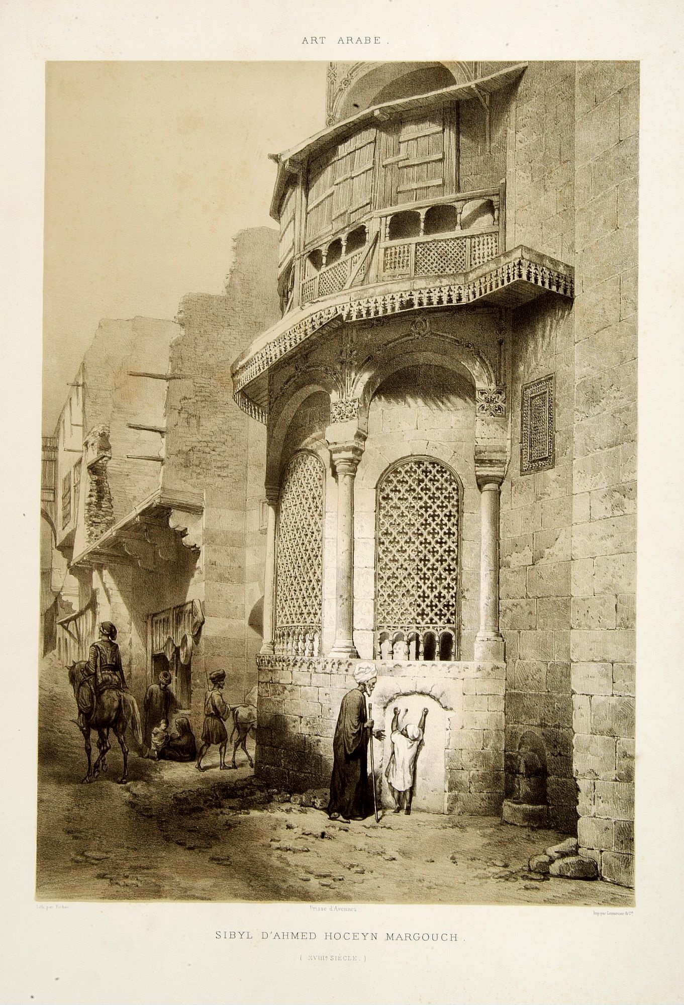
Sibyl d'Ahmed Hoceyn Margouch. |
||||||||||||||||||||
|
||||||||||||||||||||
|
|
||||||||||||||||||||
$150 / ≈ €132This item is available for immediate sale! Questions before Buying ?
We are happy to answer your questions. |
My Collection +
Add this or any of your favorite items in one place. If you want to save the items permanently, you have to sign in or create an account first. |
|||||||||||||||||||
Description
Lithograph by Fichou. From the author's "L'Art Arabe d'après les monuments du Kaire...".
Emile Prisse d'Avennes, Orientalist & Muslim convert, obsessive in his attention to detail, was after Champollion the greatest pre-20th century Egyptologist. His interests were not, however, limited to Egyptology and he produced, one of the most important books on the Islamic monuments of Egypt.
A French nobleman by birth, though impoverished, Prisse d'Avennes seems to have spent his life in the pursuit of the exotic. After a period fighting for Greek independence Prisse d'Avennes traveled to India, a journey that prefigured his extensive Middle Eastern travels, which during the next 40 years took him to Palestine, Syria, Sudan, Ethiopia, Arabia, Persia, and most importantly Egypt and Algeria where he lived. Like Coste, Prisse d'Avennes worked for the Viceroy Mehmet Ali until 1836.
After that he explored Egypt on his own disguised as an Arab using the name Edris Effendi.
In 1860, Prisse d'Avennes returned to France with the fruits of his travels: 300 folio drawings, 400 metres of bas-reliefs, 150 photographs of important architectural details, 150 sketches, daguerrotypes, numerous plans, details and elevations copied on the scene.
Until his death in 1877 this wealth of material was to occupy him completely as he sought to organize it for publication.
More about Emile Prisse d'Avennes [+]
FAQ - Guarantee - Shipping
Buying in the BuyNow Gallery
This item is available for immediate purchase when a "Add to Cart" or "Inquire Now" button is shown.
Items are sold in the EU margin scheme
Payments are accepted in Euros or US Dollars.
Authenticity Guarantee
 We provide professional descriptions, condition report (based on 45 years experience in the map business)
Paulus Swaen warrants the authenticity of our items and a certificate of authenticity is provided for each acquired lot.
Condition and Coloring
We indicate the condition of each item and use our unnique HiBCoR grading system in which four key items determine a map's value: Historical Importance, Beauty, Condition/Coloring and Rarity.
Color Key
We offer many maps in their original black and white condition. We do not systematically color-up maps to make them more sellable to the general public or buyer.
Copper engraved or wood block maps are always hand colored. Maps were initially colored for aesthetic reasons and to improve readability. Nowadays, it is becoming a challenge to find maps in their original colors and are therefor more valuable.
We use the following color keys in our catalog:
Original colors; mean that the colors have been applied around the time the map was issued.
Original o/l colors; means the map has only the borders colored at the time of publication.
Colored; If the colors are applied recently or at the end of the 20th century.
Read more about coloring of maps [+]
Shipping fee
A flat shipping fee of $ 30 is added to each shipment by DHL within Europe and North America. This covers : International Priority shipping, Packing and Insurance (up to the invoice amount).
Shipments to Asia are $ 40 and rest of the world $50
We charge only one shipping fee when you have been successful on multiple items or when you want to combine gallery and auction purchases.
Read more about invoicing and shipping
FAQ
Please have a look for more information about buying in the BuyNow gallery
Many answers are likely to find in the general help section.
My Collection+
![]()
With My Collection+ you can collect all your favorite items in one place. It is free, and anyone can create his or her virtual collection.
Unless you are logged in, the item is only saved for this session. You have to be registed and logged-in if you want to save this item permanently to My Collection+.
Read More[+]
Register here, it is free and you do not need a credit card.
Add this item to
My Collection+
or click the following link to see My Collection+.
| Digital Image Download | |
|
Paulus Swaen maintains an archive of most of our high-resolution rare maps, prints, posters and medieval manuscript scans. We make them freely available for download and study. Read more about free image download |
Click the image for a free small image download. |
In accordance with the EU Consumer Rights Directive and habitually reside in the European Union you have the right to cancel the contract for the purchase of a lot, without giving any reason.
The cancellation period will expire 14 calendar days from the day after the date on which you or a third party (other than the carrier and indicated by you) acquires, physical possession of the lot. To exercise the right to cancel you must inform Paulus Swaen Inc, of your decision to cancel this contract by a clear statement (e.g. a letter sent by post, or e-mail.
To meet the cancellation deadline, it is sufficient for you to send your communication concerning your exercise of the right to cancel before the cancellation period has expired.
Recently Viewed
Sibyl d'Ahmed Hoceyn Margouch.
Lithograph by Fichou. From the author's "L'Art Arabe d'après les monuments du Kaire...". Emile Prisse d'Avennes, Orientalist & Muslim convert, obsessive in ...
Date: Paris, 1877
