Subscribe to be notified if similar examples become available.
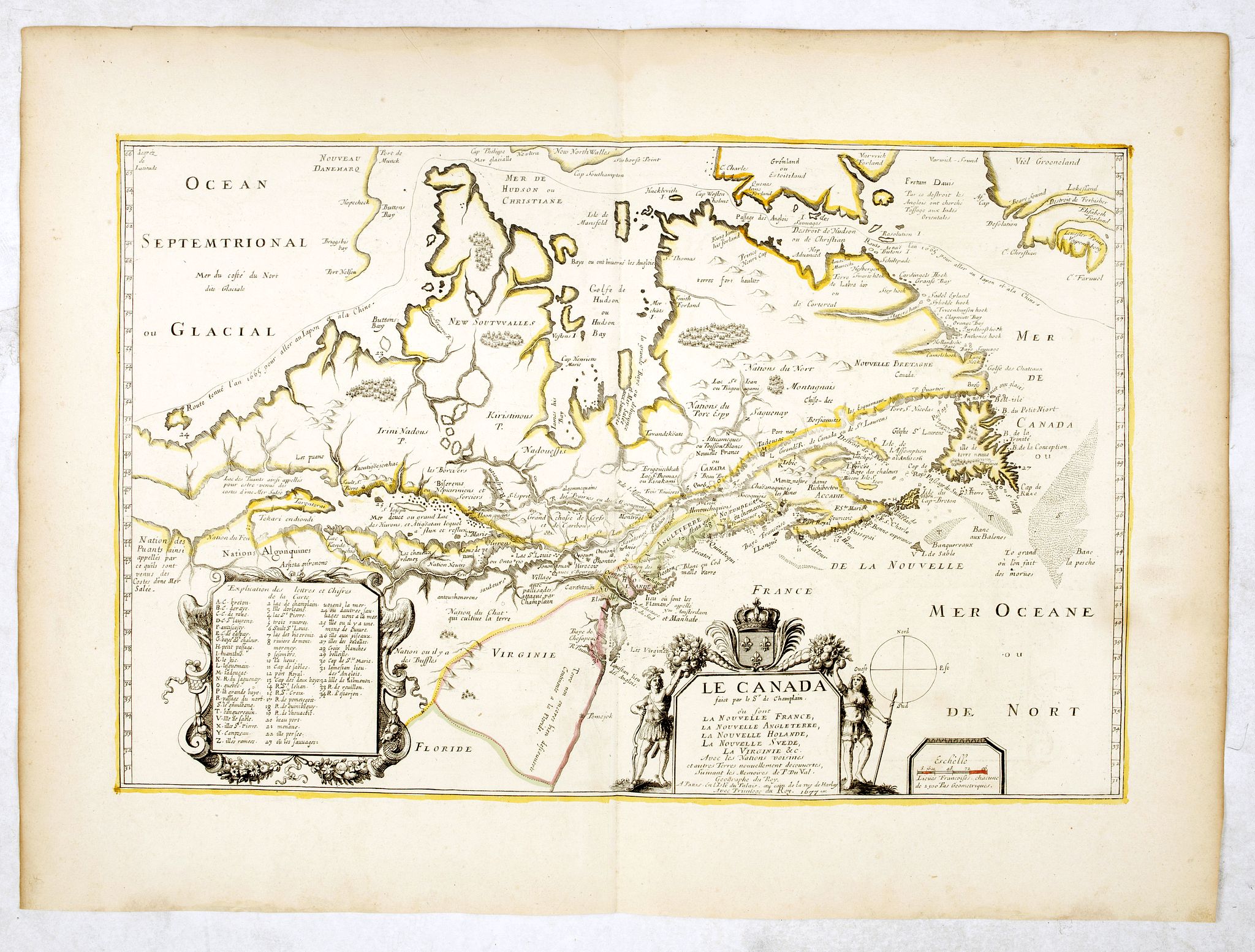
Le Canada faict par le St. De Champlain. . . |
||||||||||||||||||||
|
||||||||||||||||||||
|
|
||||||||||||||||||||
|
Selling price: $ Please login to see price!
Sold in 2016 Missed this item! Add your name to our mailing list and be the first to get notified about our newly added listings. . |
My Collection +
Add this or any of your favorite items in one place. If you want to save the items permanently, you have to sign in or create an account first. |
|||||||||||||||||||
Description
This is the sixth and final printed state of Champlain’s 1616 plate of Canada issued by Pierre Du Val. The original 1616 Champlain map was never published, and only one example of the proof state is known, located at the John Carter Brown Library. According to Wroth, Du Val somehow came into possession of the Champlain plate, printed a proof state, then re-engraved the map, making improvements, in 1653. Largely based on his 1613 map, Champlain includes information from his explorations through to Georgian Bay and back to Lake Ontario. Chesapeake Bay has also been added, and the western portion would seem to be developed from verbal Indian accounts of large bodies of water stretching westward. Champlain emphasized the discoveries of Button and the possibility of a north-west passage in the south-west corner of Hudson Bay, and this concept, particularly, was to dominate his map of 1632.
The map includes indications of the increasing whaling and fishing activities in the Canadian Arctic and the inclusion of Prince Edward Island.
Du Val’s additions to Champlain’s map included significant new nomenclature, the representation of the English in New England and Virginia, a new coastline at the north-west labeled Nouveau Danemarq, the re-drawing of southern Greenland, and a new title cartouche. By the time this 1677 edition appeared, he had also added names such as Boston, Montreal, Quebec, Accadie and Manhattan, as well as an Arctic route marked 1665, and the site of Champlain’s battle. The address in the primary cartouche has changed, and both the primary and secondary cartouches have been embellished with decorative motifs.
This is the sixth and final state of the map issued by Du Val, with Burden noting that “all of these later issues are rare.”
Reference: Burden, The Mapping of North America, 309. Maps of Canada, #79, pp. 73-78.
FAQ - Guarantee - Shipping
Buying in the BuyNow Gallery
This item is available for immediate purchase when a "Add to Cart" or "Inquire Now" button is shown.
Items are sold in the EU margin scheme
Payments are accepted in Euros or US Dollars.
Authenticity Guarantee
 We provide professional descriptions, condition report (based on 45 years experience in the map business)
Paulus Swaen warrants the authenticity of our items and a certificate of authenticity is provided for each acquired lot.
Condition and Coloring
We indicate the condition of each item and use our unnique HiBCoR grading system in which four key items determine a map's value: Historical Importance, Beauty, Condition/Coloring and Rarity.
Color Key
We offer many maps in their original black and white condition. We do not systematically color-up maps to make them more sellable to the general public or buyer.
Copper engraved or wood block maps are always hand colored. Maps were initially colored for aesthetic reasons and to improve readability. Nowadays, it is becoming a challenge to find maps in their original colors and are therefor more valuable.
We use the following color keys in our catalog:
Original colors; mean that the colors have been applied around the time the map was issued.
Original o/l colors; means the map has only the borders colored at the time of publication.
Colored; If the colors are applied recently or at the end of the 20th century.
Read more about coloring of maps [+]
Shipping fee
A flat shipping fee of $ 30 is added to each shipment by DHL within Europe and North America. This covers : International Priority shipping, Packing and Insurance (up to the invoice amount).
Shipments to Asia are $ 40 and rest of the world $50
We charge only one shipping fee when you have been successful on multiple items or when you want to combine gallery and auction purchases.
Read more about invoicing and shipping
FAQ
Please have a look for more information about buying in the BuyNow gallery
Many answers are likely to find in the general help section.
My Collection+
![]()
With My Collection+ you can collect all your favorite items in one place. It is free, and anyone can create his or her virtual collection.
Unless you are logged in, the item is only saved for this session. You have to be registed and logged-in if you want to save this item permanently to My Collection+.
Read More[+]
Register here, it is free and you do not need a credit card.
Add this item to
My Collection+
or click the following link to see My Collection+.
| Digital Image Download | |
|
Paulus Swaen maintains an archive of most of our high-resolution rare maps, prints, posters and medieval manuscript scans. We make them freely available for download and study. Read more about free image download |
Click the image for a free small image download. |
In accordance with the EU Consumer Rights Directive and habitually reside in the European Union you have the right to cancel the contract for the purchase of a lot, without giving any reason.
The cancellation period will expire 14 calendar days from the day after the date on which you or a third party (other than the carrier and indicated by you) acquires, physical possession of the lot. To exercise the right to cancel you must inform Paulus Swaen Inc, of your decision to cancel this contract by a clear statement (e.g. a letter sent by post, or e-mail.
To meet the cancellation deadline, it is sufficient for you to send your communication concerning your exercise of the right to cancel before the cancellation period has expired.
