Browse Listings in America > Canada > Canada maps

Carte du Canada ou de la Nouvelle France.
A later edition of Guillaume De l'Isle's map. It still includes the fictitious discoveries of Baron de Lahoutan: the legendary River Longue etc. The northwest corner of H...
Date: Amsterdam, 1730
Carte Reduite, des Cotes De L'Acadie, de L'Isle Royale, et de la Partie Meridionale de L'Isle de Terre Neuve.
An important chart of Nova Scotia, southern Newfoundland and the Grand Banks, prepared after Chabert's voyage to Canada to update the French charts of Eastern Canada. It ...
Date: Paris, 1753

Carte Réduite De La Partie Septentrionale De L'' Isle De Terre Neuve..
A well engraved and highly detailed chart, corrected to 1767. Elaborate hand-colored cartouche, rhumb lines.Shows northern part of Newfoundland and southern coast of Labr...
Date: Paris, 1767
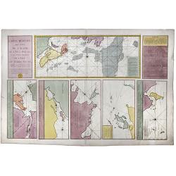
![The Coast of New Found Land From Salmon Cove to Cape Bonavista. . . [together with] The Coast of New Found Land from Cape-Raze to Cape St-Francis.](/uploads/cache/40658-250x250.jpg)
The Coast of New Found Land From Salmon Cove to Cape Bonavista. . . [together with] The Coast of New Found Land from Cape-Raze to Cape St-Francis.
Two charts showing the coast of New Found Land from Salmon Cove to Cape Bonavista and from Cape-Raze to Cape St-Francis. With inset chart of Trinity HarborGrierson publis...
Date: Dublin, 1767

Nieuwe kaart van Kanada . . .
Nice map of the Bay of Hudson, In Labrador, a small inset of Nova Scotia. The map is dated 1769. All text is in Dutch. The map shows the region shortly after the conclusi...
Date: Amsterdam, 1769

Plan der Stadt Quebec Haupstadt in Neu Franckreich oder Canada.
Town-plan of Quebec, with an inset view of the town in the lower right corner. In the upper right a recapitulation of the main military actions prior to the surrender of ...
Date: Nurnberg, 1770
![[Haida Gwaii,] Baye Swallow . . . / Havre Byron /Côté septentrional de la plus grande des Isles de la Reine Charlotte. . . .](/uploads/cache/25888-250x250.jpg)
[Haida Gwaii,] Baye Swallow . . . / Havre Byron /Côté septentrional de la plus grande des Isles de la Reine Charlotte. . . .
Map of Swallow's Bay and a coastline profile of the Queen Charlotte Islands and Captain Byron's Heaven.Queen Charlotte Islands, with their modern name Haida Gwaii, is an ...
Date: Paris, 1774

Carte de la partie septentrionale des Etats Unis..
An attractive 1801 map of North America's east coast north of Long Island. Including St.Laurence River as far south as Lake Ontario. Engraved by André and P.F.Tardieu. A ...
Date: Paris, 1801
![[Canadian Indian traditional garments ].](/uploads/cache/27544-250x250.jpg)
[Canadian Indian traditional garments ].
Aquatint depicting Canadian Indian traditional garments engraved by Gallina. Plate N°32.From Giulio Ferrario's work Le Costume Ancien et Moderne ou Histoire du gouverneme...
Date: Milan, 1827
![[Canadian Indians ].](/uploads/cache/27546-250x250.jpg)
[Canadian Indians ].
Aquatint depicting a group of Canadian Indians engraved by Gallina. Plate N° 33 n°1.From Giulio Ferrario's work Le Costume Ancien et Moderne ou Histoire du gouvernement, ...
Date: Milan, 1827

Cunard to Canada.
Poster by Charles Eddowes Turner for Cunard lines. The poster shows The NEW SYLVANIA, one of the four new 22,000 - ton Cunarders which are the largest ever built for serv...
Date: England, ca. 1930
