Browse Listings
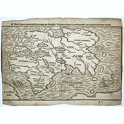
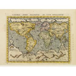
Dese Caerte van de beschrijvinghe der Wereldt.
Extremely rare world map by H. Bünting. Shows part of America and Australia. Printed by Reynder Wylicks in Utrecht. From the first Dutch edition of Henricus Bünting`s &...
Date: Utrecht, 1596
Selling price: ????
Please login to see price!
Sold in 2014
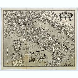
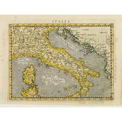
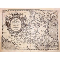
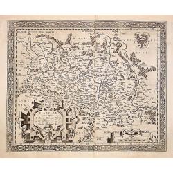
Italia.
Map of Italy adorned with a title-cartouche, 6 ships, a sea monster and a scale. This is a rare copper-engraved map of Italy based on the Mercator projection. Present in ...
Date: Frankfurt, 1596
Selling price: ????
Please login to see price!
Sold in 2020
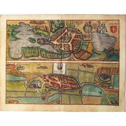
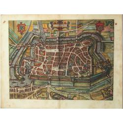
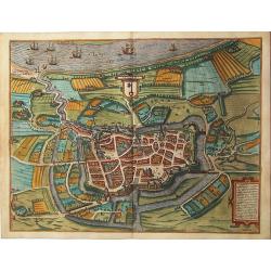
Oitinense oppidulum et arx Episcopi Lubecensis sedes / Delineatio Civitatis Tonderensis. Tonder - Eutin
Two bird's-eye plans on one sheet: Tønder (Denmark) and Eutin (Germany) by Braun & Hogenberg.From: Civitates Orbis Terrarum, ... Part 5. Köln, 1596 EUTINCAPTION: Eu...
Date: Cologne 1596
Selling price: ????
Please login to see price!
Sold in 2020
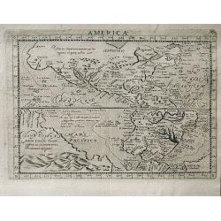
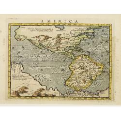
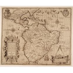
America.
A very attractive map of the American continent by Magini with a large area called ‘Nova Guinea’ and an uninterrupted coastline of the Arctic circle. This is a reduce...
Date: Venice, 1596
Selling price: ????
Please login to see price!
Sold in 2019
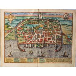
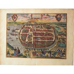
Visbia Gothorum. Visby / Gotland.
A fine antique map - bird's-eye view / plan of Visby on Gotland by Braun and Hogenberg, from: Civitates Orbis Terrarum, ... Part 5. Köln, 1596.TRANSLATION OF CAPTION: In...
Date: Cologne, 1596
Selling price: ????
Please login to see price!
Sold in 2020
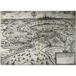
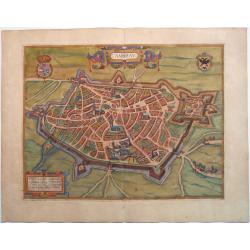
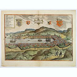
Antwerpia
Siege of Antwerp and blockade of the river "Schelde" by the Duke of Parma, 1584-1585.Originally engraved by Frans Hogenberg. For this second edition the text un...
Date: Cologne, 1596
Selling price: ????
Please login to see price!
Sold in 2020
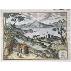
Elegantissimus ad mare Thyrrenum ex monte Pausillipo Neapolis montisque Vesuvij prospectus.
A general view of Naples from Posillipo, from “Civitates Orbis Terrarum”. An old map - bird's-eye view of the Bay of Naples with mount Vesuvius, by Braun and Hogenber...
Date: Köln, 1596
Selling price: ????
Please login to see price!
Sold in 2021
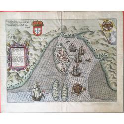
Insulae et arcis Mocambique descriptio ad fines Melinde.
An attractive and rare bird's-eye view of Melinde harbour in Mozambique, engraved by Jan Deutecum for Linschoten's 'Itinerario', published between 1596 and 1644. Probably...
Date: Amstrerdam, 1596
Selling price: ????
Please login to see price!
Sold in 2020
![RATZENBURGK [RATZEBURG.]](/uploads/cache/84682-250x250.jpg)
RATZENBURGK [RATZEBURG.]
A fine antique map - bird's-eye view of Ratzeburg by Braun & Hogenberg, signed and dated bottom centre: Gerdt Hane 1588. From: Urbium Praecipuarum Mundi Theatrum Quin...
Date: Cologne,1596
Selling price: ????
Please login to see price!
Sold in 2020
![BREMA [BREMEN.]](/uploads/cache/84683-250x250.jpg)
BREMA [BREMEN.]
A fine antique map - bird's-eye view of Bremen by Braun and Hogenberg, from the rare: Urbium Praecipuarum Mundi Theatrum Quintum Auctore Georgio Braunio Agrippinate. Part...
Date: Cologne, 1596
Selling price: ????
Please login to see price!
Sold in 2020
![Saarburg & Pfalzel, Chorographica descriptio Civitatis Sarburgensis [on sheet with] Opp: Palatinum ad Mosellam Flu; vulgo Pfaltz auff der Musell.](/uploads/cache/84684-250x250.jpg)
Saarburg & Pfalzel, Chorographica descriptio Civitatis Sarburgensis [on sheet with] Opp: Palatinum ad Mosellam Flu; vulgo Pfaltz auff der Musell.
A fine antique map with two bird's-eye views by Braun and Hogenberg: Saarburg and Pfalzel, from: Civitates Orbis Terrarum, ... Part 5. Köln, 1596. COMMENTARY BY BRAUN (o...
Date: Cologne, 1596
Selling price: ????
Please login to see price!
Sold in 2020
![Zell,Berncastel,Manderscheid - Cel im Ham, Berncastel, Ober Manderscheidt, Nider Manderscheidt. [on one sheet]](/uploads/cache/84685-250x250.jpg)
Zell,Berncastel,Manderscheid - Cel im Ham, Berncastel, Ober Manderscheidt, Nider Manderscheidt. [on one sheet]
A fine antique map with three bird's-eye views on one sheet: Zell - Berncastel - Manderscheid, from: Civitates Orbis Terrarum, ... Part 5. Köln, 1596.ZELL AN DER MOSEL. ...
Date: Cologne, 1596
Selling price: ????
Please login to see price!
Sold in 2020
LUNEBORCH - Lüneburg.
A fine antique map - birds eye view of Lüneburg in northern Germany ,by Braun and Hogenberg. From the rare 5th volume of 'Civitates Orbis Terrarum..'
Date: Cologne, 1596
Selling price: ????
Please login to see price!
Sold in 2020
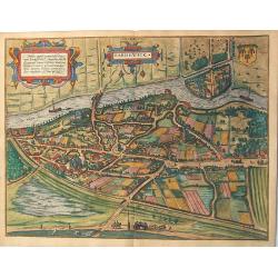
BARDOWICK - Bardewick.
A fine antique map - bird's-eye view of Bardowick by Braun and Hogenberg, engraved after a drawing by Daniel Freese, 1588.From the rare: Civitates Orbis Terrarum, ... Par...
Date: Cologne, 1596
Selling price: ????
Please login to see price!
Sold in 2020
BARDUM POMERANIAE, BARTH/POMERANIA.
A fine antique map - bird's-eye plan of Barth by Braun and Hogenberg, from the Urbium Praecipuarum Mundi Theatrum Quintum Auctore Georgio Braunio Agrippinate. Part 5. Kö...
Date: Cologne, 1596
Selling price: ????
Please login to see price!
Sold in 2020
Cochem + Münstermaifeld, Chorographica Descriptio Civitatis Cocheimensis, Exactissima Civitatis Monasteriensis. . .
A fine antique map with a view of Cochem and a bird's-eye plan of Münstermaifeld by Braun and Hogenberg, with key to locations. From the: Civitates Orbis Terrarum, ...th...
Date: Cologne, 1596
Selling price: ????
Please login to see price!
Sold in 2020
Stade / Staden.
A fine antique map - a bird's-eye plan of Stade by Braun and Hogenberg, from: Urbium Praecipuarum Mundi Theatrum Quintum Auctore Georgio Braunio Agrippinate. Part 5. Köl...
Date: Cologne, 1596
Selling price: ????
Please login to see price!
Sold in 2020
Plön / Plona.
A fine antique map - a bird's-eye view of Plön by Braun and Hogenberg, from the: Civitates Orbis Terrarum, ... Part 5. Köln, 1596.TRANSLATION OF CARTOUCHE TEXT: Drawn o...
Date: Cologne, 1596
Selling price: ????
Please login to see price!
Sold in 2021
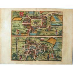
Heide + Meldorf, Icon Oppidi Heide / Delineatio Urbis Meldorpie.
A fine antique map with two bird's-eye plans by Braun and Hogenberg: Heide and Meldorf. From: Civitates Orbis Terrarum, ... Part 5. Köln, 1596.HEIDE. TRANSLATION OF CAPT...
Date: Cologne, 1596
Selling price: ????
Please login to see price!
Sold in 2020
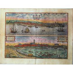
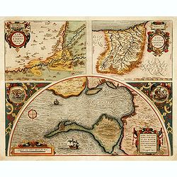
Elsenor / Ripen. Helsingør (Sjaelland) & Ribe (Jutland).
A fine antique engraving with two panoramic views by Braun and Hogenberg on one sheet: Helsingør (Sjaelland) & Ribe (Jutland), from Braun G. & Hogenberg F. Civit...
Date: Cologne, 1596
Selling price: ????
Please login to see price!
Sold in 2020
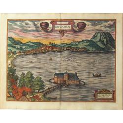
Gmunden.
A fine antique map - a bird's-eye view of Gmunden by Braun and Hogenberg, engraved by G. Hoefnagel after L. van Valkenborch, 1594, from: Urbium Praecipuarum Mundi Theatru...
Date: Cologne, 1596
Selling price: ????
Please login to see price!
Sold in 2020
![Ratisbona [Regensburg.]](/uploads/cache/84712-250x250.jpg)
Ratisbona [Regensburg.]
A fine antique map - a bird's-eye view of Regensburg by Braun and Hogenberg, drawn and engraved by J. Hoefnagel in 1594. Dedicated to Emperor Rudolph II. From the: Urbium...
Date: Cologne, 1596
Selling price: ????
Please login to see price!
Sold in 2020
![Wiismaria [Wismar.]](/uploads/cache/84713-250x250.jpg)
Wiismaria [Wismar.]
A fine antique panoramic view of Wismar by Braun and Hogenberg, from the: Civitates Orbis Terrarum, ... Part 5. Köln, 1596.COMMENTARY BY BRAUN: "The town has greatl...
Date: Cologne, 1596
Selling price: ????
Please login to see price!
Sold in 2020
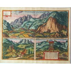
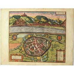
Inn Valley.
A fine antique map with three views by Braun and Hogenberg: View of the Innvalley; a view of the "Schlosberg" and a view of a monument for the emperor Carolus V...
Date: Cologne, 1596
Selling price: ????
Please login to see price!
Sold in 2020
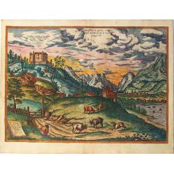
Linsum Austriae vulgo Lintz. Linz.
A fine antique bird's-eye view of Linz, with key to locations by Braun & Hogenberg, from: Urbium Praecipuarum Mundi Theatrum Quintum Auctore Georgio Braunio Agrippina...
Date: Cologne, 1596
Selling price: ????
Please login to see price!
Sold in 2020
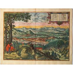
Innsbruck.
A fine antique view of Ambras castle with Innsbruck in the distance, by G. Hoefnagel after Alexander Colijn, from: Braun & Hogenberg, Civitates Orbis Terrarum, ... Pa...
Date: Cologne, 1596
Selling price: ????
Please login to see price!
Sold in 2020

Dithmarschen Costumes. Diversi Dithmarsorum et vicinarum gentium habitus.
A fine antique engraving of costumed figures from the 'Civitates Orbis Terrarum', it shows the dignitaries and peasants of Dithmarschen. In the 15/16th centuries Dithmars...
Date: Cologne,1596
Selling price: ????
Please login to see price!
Sold in 2020
CAMBRAI. - La Ville de Cambray.
A handsome birds-eye view/map of the northeast French city of Cambrai, from "Civitates Orbis Terrarum", in fine color. With a strong graphic element of the ...
Date: Cologne, 1596
Selling price: ????
Please login to see price!
Sold in 2021
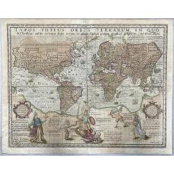
Typus Totius Orbis Terrarum, In Quo & Christiani militis certamen super terram.
The very rare so-called 'Christian Knight' world map, published by Jodocus Hondius. The first map on Mercator's projection to be produced after his death and also famous ...
Date: Amsterdam, 1597
Selling price: ????
Please login to see price!
Sold in 2020
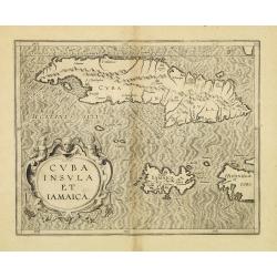
Cuba Insula et Jamaica.
One of only two Caribbean maps in this important work, which was one of the first atlases to provide detailed maps on the individual regions in the New World. The map is ...
Date: Louvain, 1597
Selling price: ????
Please login to see price!
Sold in 2012
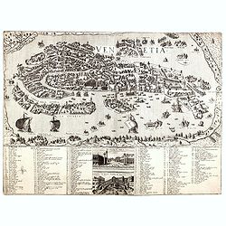
Venetia.
First state (unknown before) of this spectacular town-plan of Venice published engraved by Stefano Scolari, after the Bernardo Salvioni (1597) plan of Venice. It's the fi...
Date: Venice, c.1597
Selling price: ????
Please login to see price!
Sold
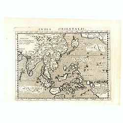
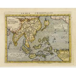
India Orientalis.
Attractive strong impression showing all island groups, including the Philippines and Japan.Also shows the West Coast of North America with the place name of Quivira.The ...
Date: Cologne, 1597
Selling price: ????
Please login to see price!
Sold in 2017
Brasilia
A map of Brazil from "Descriptionis Ptolemaicae Augmentum, sive Occidentis Notitia" published in 1597. First edition, paper size 30 x 37 cm, map size: 28.4 cm x...
Date: 1597
Selling price: ????
Please login to see price!
Sold in 2016
Utriusque Hemispherii Delineatio
From "Descriptionis Ptolemaicae Augmentum, sive Occidentis Notitia" published in 1597. First edition, paper size 30 x 37 cm. This delicately engraved world map ...
Date: 1597
Selling price: ????
Please login to see price!
Sold in 2017
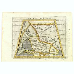
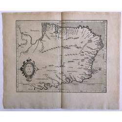
Tabula Asiae II.
A striking example of Magini's map of the Black Sea region, from the 1597 edition of Magini's 'Geographia', based upon the work of Claudius Ptolemy. Latin text and tables...
Date: Venice, 1597
Selling price: ????
Please login to see price!
Sold in 2016
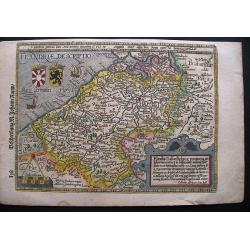
FLANDRIAE DESCRIPTIO.
A highly decorative and rare map of Flanders by Matthias Quad, published in the Cosmographia by Johann Rauw in 1597. On verso a woodcut plan of Brussels.
Date: Frankfurt, 1597
Selling price: ????
Please login to see price!
Sold in 2020
![Stocholmia [Stockholm].](/uploads/cache/42581-250x250.jpg)
Stocholmia [Stockholm].
The top engraving, showing the timber houses so typical of Scandinavia, is a view from the northeast across what was then the suburb of Norrmalm and is now the city centr...
Date: Cologne, 1588-1597
Selling price: ????
Please login to see price!
Sold in 2018
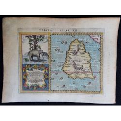
Tabula Asiae XII.
A very decorative copperplate map of Ceylon / Sri Lanka with a very elaborate cartouche and a charming engraving of an elephant.From the 1597 edition of Magini's "Ge...
Date: Venice, 1597
Selling price: ????
Please login to see price!
Sold in 2018
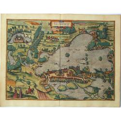
Bergen.
The delightful Braun & Hogenberg bird's-eye view of the Norwegian city of Bergen, founded in 1070 and fortified with a palisade, is seen from the southwest across Và...
Date: Cologne, 1588-1597
Selling price: ????
Please login to see price!
Sold in 2018
(America)
An engraved map, consisting of the right hand part of a two sheet map of the Americas. Fausto Rughesi, a native of Montepulicano, is best known as Roman architect, his ma...
Date: Rome, c.1597
Selling price: ????
Please login to see price!
Sold in 2019
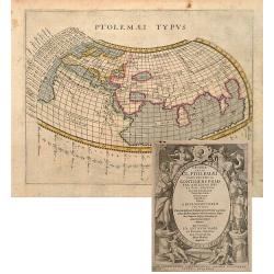
Ptolemaei Typus.
A very attractive Ptolemaic world map, following the standard classical format. Printed by Petrus Keschedt.
Date: Cologne 1597
Selling price: ????
Please login to see price!
Sold
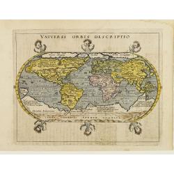
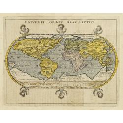
Universi Orbis Descriptio.
Modern world map from Magini's atlas following the oval projection popularised by Ortelius.Porro has astutely reduced Ortelius' much larger map to octavo page size with v...
Date: Cologne 1597
Selling price: ????
Please login to see price!
Sold
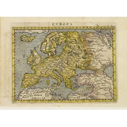
Europa.
Map of Europe, including great part of northern Africa and the Near East.The map comes from a scarce pirate edition published by Petrus Keschedt in Cologne one year after...
Date: Cologne 1597
Selling price: ????
Please login to see price!
Sold
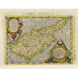
Cypri Insvla.
Lovely copper engraved map of the island of Cyprus featuring two large cartouches and fancy lettering in the seas. Good detail in the interior.The map comes from a scarce...
Date: Cologne 1597
Selling price: ????
Please login to see price!
Sold
America.
A very attractive map. This is a reduced version of Giovanni d'Anian's 1582 Map of America.The geography is derived mainly from Ortelius' earlier map of the Western Hemis...
Date: Cologne 1597
Selling price: ????
Please login to see price!
Sold
Italia.
Lovely copper engraved map of Italy featuring fancy lettering in the seas. Southern part of Sicily and Sardinia are not included. Good detail in the interior.The map come...
Date: Cologne 1597
Selling price: ????
Please login to see price!
Sold
India Orientalis.
Attractive strong impression showing all island groups, including the Philippines and Japan.Also shows the West Coast of North America with the place name of Quivira.The ...
Date: Cologne 1597
Selling price: ????
Please login to see price!
Sold
Universi Orbis Descriptio Ad Usum Navigantium.
Magini's mariner's map follows Gerard Mercator's large world map of 1569 on a much reduced scale.The map comes from a scarce pirate edition published by Petrus Keschedt i...
Date: Cologne 1597
Selling price: ????
Please login to see price!
Sold
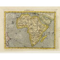
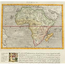
Africa.
Small map of Africa and the Arabian Peninsula showing part of Brazil as well.The rivers of central and north Africa feature prominently including the Ptolemaic concept of...
Date: Cologne 1597
Selling price: ????
Please login to see price!
Sold
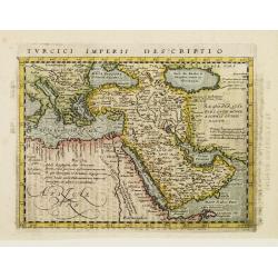
Turcici Imperii Descriptio.
Small engraving showing the Ottoman Empire, the Mediterranean Sea, northern Africa, the Holy Land and Arabia.The map comes from a scarce pirate edition published by Petru...
Date: Cologne 1597
Selling price: ????
Please login to see price!
Sold
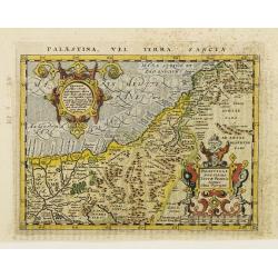
Palaestina, Vel Terra Sancta.
Map of the Holy Land with two large strapwork cartouches. The map comes from a scarce pirate edition published by Petrus Keschedt in Cologne one year after the publicatio...
Date: Cologne 1597
Selling price: ????
Please login to see price!
Sold
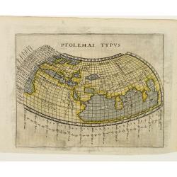
Ptolemaei Typus.
A very attractive Ptolemaic world map, following the standard classical format.On verso frontispiece from Geographiae Cl. Ptolemaei Pars secunda.. Avthore Io. Antonio Mag...
Date: Cologne 1597
Selling price: ????
Please login to see price!
Sold
Universi Orbis Descriptio.
Modern world map from Magini's atlas following the oval projection popularized by Ortelius.Porro has astutely reduced Ortelius' much larger map to octavo page size with v...
Date: Cologne, 1597
Selling price: ????
Please login to see price!
Sold
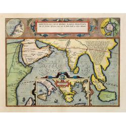
Erythraei Sive Rubri Maris Periplus.
Decorative map covering the north-west coast of Africa, Arabian peninsular, India, Malaysia. In lower part inset map of Mediterranean.Upper right hand corner inset map Hy...
Date: Antwerp, 1597
Selling price: ????
Please login to see price!
Sold in 2008
Antiquae Urbis perfecta imago. (Rome)
From "Pars antiquitatum Romanarum seu Topographia Romanae Urbis iam inde ab V. C. ad nostra usque temporae maxime quando in summo flore fuit, accuratissima: [...] Ma...
Date: Frankfurt, 1597
Selling price: ????
Please login to see price!
Sold in 2013
Africa.
From "Geografia". Published in Venice by Galignani. Situated in a text page, with a gold leaf initial. Maps are engraved by Girolamo Porro.
Date: Venice, ca. 1597
Selling price: ????
Please login to see price!
Sold in 2008
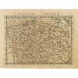
Poloniae Regnum.
A detailed map of Poland, Lithuania and the Ukraine stretching from the Baltic Sea in the north to the Black Sea in the south.Latin text on verso.The map comes from the G...
Date: Cologne, 1597
Selling price: ????
Please login to see price!
Sold in 2010
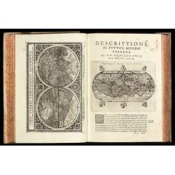
Geografia cioe Descrittione Universale della Terra ... Nuovamente ... Rincontrati, & Corretti ... Gio. Ant. Magini ... Opera ... Tradotta dal R.D. Leonardo Cernoti
The first edition of Leonardo Cernoti's Italian translation of Ptolemy's Geografia based on the 1596 Latin edition of Magini published by G. B. & G. Galignani in 1597...
Date: Venice, 1597
Selling price: ????
Please login to see price!
Sold in 2011
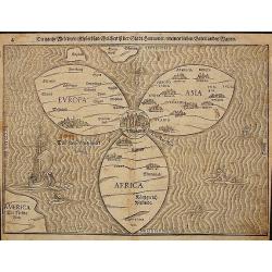
Die gantze Welt in ein Kleberblat.
The world is depicted as a trefoil cloverleaf with Jerusalem at the center. Woodcut map from Heinrich Buenting's "Itinerarium sacrae scripturae", printed by Pau...
Date: Magdeburg, 1597
Selling price: ????
Please login to see price!
Sold in 2011
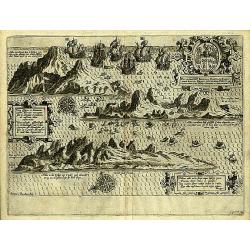
Insula D.Helenae sacra coeli..
A fine perspective view of the Island of St.Helena in the South Atlantic. The location of the Island directly on the navigation route from Europe to the Cape of Good Hope...
Date: Amsterdam 1598
Selling price: ????
Please login to see price!
Sold
Romaniae, (quae olim Thracia dicta) ..
Very fine map centered on the Danube area. The map is based on the double sheet map by Jacob Gastaldi. Abraham Ortelius (1527-1598) was a cartographer and publisher, who ...
Date: Antwerp 1598
Selling price: ????
Please login to see price!
Sold
Basiliensis territorii descriptio nova./Circulus sue Liga..
Left hand map centred on Basle, east to top. With credit to Sebastian Münster in title cartouche.Right hand map with Boden See, Strasbourg and Augsburg. The map was prep...
Date: Antwerp, 1598
Selling price: ????
Please login to see price!
Sold in 2016
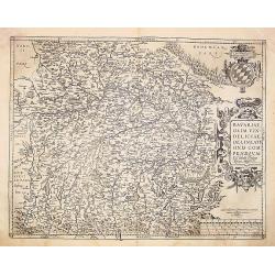
Bavariae, olim vindeliciae delineationis..
Fine and early map of Bavaria, prepared by Philipp Apian in 1561 and used by Ortelius in his atlas 'Theatrum Orbis Terrarum [Atlas of the Whole World].The Theatrum was re...
Date: Antwerp 1598
Selling price: ????
Please login to see price!
Sold
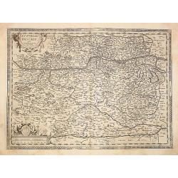
Austriae ducatvs chorographia, Wolfgango Lazio auctore
Fine and early map of Austria after Wolfgang Lazius and used by A.Ortelius in his atlas 'Theatrum Orbis Terrarum [Atlas of the Whole World].Only included in the atlas edi...
Date: Antwerp 1598
Selling price: ????
Please login to see price!
Sold
Silesiae typus..
Fine and early map of Silesia after Martin Helwig (1516-1574) and used by A.Ortelius in his atlas 'Theatrum Orbis Terrarum [Atlas of the Whole World].Only included in the...
Date: Antwerp 1598
Selling price: ????
Please login to see price!
Sold
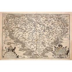
Regni Bohemiae descriptio.
Fine and early map of Czechoslovakia after Johann Criginger. and used by A.Ortelius in his atlas 'Theatrum Orbis Terrarum [Atlas of the Whole World].The Theatrum was re-i...
Date: Antwerp 1598
Selling price: ????
Please login to see price!
Sold
Americae pars magis cognita.
Very early and RARE map of Central and South America by Theodore de Bry. In the third part of his Grand Voyages Theodore de Bry publishes the accounts of the voyages of J...
Date: Frankfurt 1598
Selling price: ????
Please login to see price!
Sold
Carpetaniae Partis Desc.1584. -Guipus Coae Regionis Typus.
An ornate and highly decorative set of three maps on one sheet, Carpetanin, (upper left), Guipuzcoa, (upper right) and Cadiz (lower center). The maps are highly decorativ...
Date: Antwerp 1598
Selling price: ????
Please login to see price!
Sold
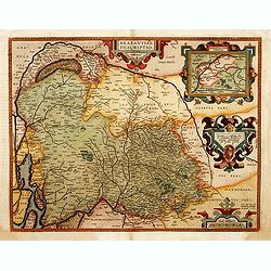
Brabantiae Descriptio.
In an inset Mechelen and surroundings. Decorative scale and title cartouche with dedicational initials which may refer to Laurentius Michaelis who may be connected with t...
Date: Antwerp 1598
Selling price: ????
Please login to see price!
Sold
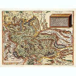
Helvetiae descriptio.
A fine map based upon a map by the Swiss cartographer Aegidicus Tschudi of 1538.
Date: Anvers, 1598
Selling price: ????
Please login to see price!
Sold
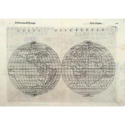
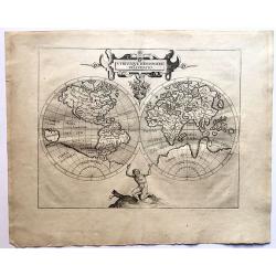
Orbis descriptio.
The map is elegantly designed and engraved on copper with typical Italian taste and skill. Separate double-hemispherical maps were no innovation but this is the first tim...
Date: Venise 1561/1598
Selling price: ????
Please login to see price!
Sold
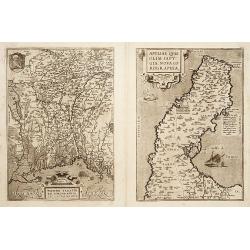
Patavini territorii../ Tarvisini agri typus.. (2 maps)
Two maps on one sheet. Map to the left is a detailed map including Venice and the area north of it including Padua and Vincenza. Very fine map after Giacomo Gastaldi. The...
Date: Antwerp 1598
Selling price: ????
Please login to see price!
Sold
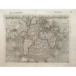
Carta Marina nuova tavola.
Ruscelli's mariner's map is a slightly enlarged version of the map which appeared in Gastaldi's edition of Ptolemy thirteen years earlier. The only change seems to be the...
Date: Venice, 1598
Selling price: ????
Please login to see price!
Sold
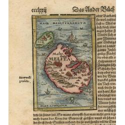
Melita.
This tiny map, set into a sheet of text, is one of the earliest available maps of the strategically important Mediterranean islands of Malta and Gozo. The woodblock map s...
Date: Basle, 1598
Selling price: ????
Please login to see price!
Sold in 2010
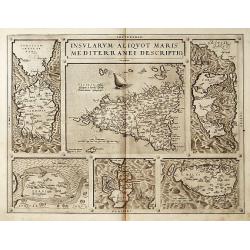
Insularum Aliquot Maris Mediterranei Descriptio.
Six maps on one sheet. In the center a map of Sicily, surrounded by maps of Sardinia, Djerba, The island of Elbe, Corfu and Malta.
Date: Antwerp 1598
Selling price: ????
Please login to see price!
Sold
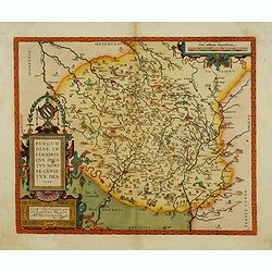
Burgundiae inferioris quae Ducatus Nomine Censetur, Des.
Centered on the province of Burgundy, from his 'Theatrum Orbis Terrarum'.
Date: Antwerp 1598
Selling price: ????
Please login to see price!
Sold
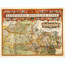
Leodiensis Diocesis Typus.
East to the top. Centered on Liege, including southern part of Dutch Limburg. Prepared by Jan van Schille.
Date: Antwerp 1598
Selling price: ????
Please login to see price!
Sold in 2009
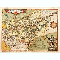
Namurcum Comitatus.
Prepared by Jacques Surhon in 1555. His manuscript map was for security reason not published. Only in 1579, when Antwerp was independent for a short time, Ortelius used a...
Date: Antwerp 1598
Selling price: ????
Please login to see price!
Sold in 2009
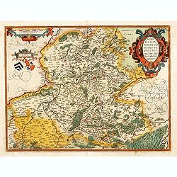
Nobilis Hanoniae Comitatus descrip.
Including part of Belgium and northern part of France.
Date: Anvers, 1598
Selling price: ????
Please login to see price!
Sold in 2009
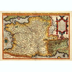
Galliae Regni Potentiss: Nova Descriptio Ioanne Ioliveto Auc
A decorative view of 16th Century France that is derived from Jean Jolivet's woodcut map of 1560. Decorated with one large cartouche and one smaller royal crest. The map ...
Date: Anvers, 1598
Selling price: ????
Please login to see price!
Sold