Please login to see price!.
Subscribe to be notified if similar examples become available.
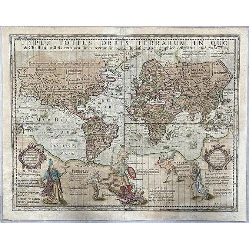
Typus Totius Orbis Terrarum, In Quo & Christiani militis certamen super terram. |
||||||||||||||||||||
|
||||||||||||||||||||
|
|
||||||||||||||||||||
|
Selling price: $...
Please login to see price! Sold in 2020 Missed this item! Be the first to get notified about our newly added listings. Add your name to our mailing list. Feel free to contact us if you have a question about this item. |
Virtual Collection - Save and collect this or any of your favorite items in one place.
If you want to save the items permanently, please sign in or create account first. |
|||||||||||||||||||
Description
The very rare so-called 'Christian Knight' world map, published by Jodocus Hondius.
The first map on Mercator's projection to be produced after his death and also famous for its up-to-date cartography, including Walter Raleigh's Lost Colony of Roanoke, and showing the results of the circumnavigations by Drake and Cavendish.
The map includes several finely engraved figures of a Christian knight assailed by Mundus, Peccatum, Caro, Diabolus and Mors, with quotations from Scripture. These are likely derived from an engraving by Jerome Wierix, after Martin de Vos and form a fascinating commentary.
The map is dedicated to R.Brewer, H.Briggs and Edward Wright.
Peter Barber wonderfully explains the artistic figures at the bottom of this map: "The scene at the foot of the map, showing the Christian Knight struggling against (reading from the left) Worldly Vanity, Sin, Carnal Weakness, the Devil and Death, might be dismissed today as mere conventional morality.
Yet Hondius's contemporaries, who were as familiar with visual allegories and the Bible as we are with crossword puzzles and television programmes, would have known differently.
They would have noticed the face of the knight bore more than a passing resemblance to Henri IV of France (an ally of Elizabeth of England), who was then going through a critical phase in his war against Catholic Spain.
(The figures fighting him symbolize Catholicism: (left to right) Worldly Vanity, Sin, Carnal Weakness, the Devil, and Death.)
The chalice borne by the figure of the World ('Mundus')is identified as having once been owned by the Whore of Babylon-a familiar Protestant term of abuse for the Papacy.
The biblical texts further emphasize the fight between (Protestant) good and (Catholic) evil". (P.Barber and C.Board in "Tales from the map room: Fact and fiction about maps and their makers". p.24-25. 1993.)
From the 1560s to 1648 Holland was engaged in a war of independence with Catholic Spain. Jodocus Hondius, who made this map, was a Dutch Protestant. The human figures on the map illustrate the battle between Catholics and Protestants.
Jodocus Hondius included the names of the explorers Columbus and Vespucci in North America, Ferdinand Magellan at Tierra del Fuego (southern tip of South America), John Davis (at the east coast of Canada), and Willem Barentsz' at Nova Zembla.
Only six other examples are recorded today: Ann Arbor, William L. Clements Library (Maps 8-C-19); London, The British Library (Maps 188.k.1 [5]); London, The Royal Geographical Society (264 H 14 [4]); Nürnberg, Germanisches Nationalmuseum (Qu. 4 H 2229)1; Wells-next-the Sea, Holkham Hall (Innys Collection) UK; Wien, Österreichische Akademie der Wissenschaften (Woldan Collection [K-V(Bl):WE 49]).
Reference: Shirley, World, 198.
FAQ - Guarantee - Shipping
Buying in the BuyNow Gallery
This item is available for immediate purchase when a "Add to Cart" or "Inquire Now" button is shown.
Items are sold in the EU margin scheme
Payments are accepted in Euros or US Dollars.
Authenticity Guarantee
 We provide professional descriptions, condition report (based on 45 years experience in the map business)
Paulus Swaen warrants the authenticity of our items and a certificate of authenticity is provided for each acquired lot.
Condition and Coloring
We indicate the condition of each item and use our unnique HiBCoR grading system in which four key items determine a map's value: Historical Importance, Beauty, Condition/Coloring and Rarity.
Color Key
We offer many maps in their original black and white condition. We do not systematically color-up maps to make them more sellable to the general public or buyer.
Copper engraved or wood block maps are always hand colored. Maps were initially colored for aesthetic reasons and to improve readability. Nowadays, it is becoming a challenge to find maps in their original colors and are therefor more valuable.
We use the following color keys in our catalog:
Original colors; mean that the colors have been applied around the time the map was issued.
Original o/l colors; means the map has only the borders colored at the time of publication.
Colored; If the colors are applied recently or at the end of the 20th century.
Read more about coloring of maps [+]
Shipping fee
A flat shipping fee of $ 30 is added to each shipment by DHL within Europe and North America. This covers : International Priority shipping, Packing and Insurance (up to the invoice amount).
Shipments to Asia are $ 40 and rest of the world $50
We charge only one shipping fee when you have been successful on multiple items or when you want to combine gallery and auction purchases.
Read more about invoicing and shipping
FAQ
Please have a look for more information about buying in the BuyNow gallery
Many answers are likely to find in the general help section.
Virtual Collection
![]()
With Virtual Collection you can collect all your favorite items in one place. It is free, and anyone can create his or her Virtual map collection.
Unless you are logged in, the item is only saved for this session. You have to be registed and logged-in if you want to save this item permanently to your Virtual Collection.
Read More[+]
Register here, it is free and you do not need a credit card.
Add this item to
Virtual Collection
or click the following link to see my Virtual Collection.
| Digital Image Download | |
|
Paulus Swaen maintains an archive of most of our high-resolution rare maps, prints, posters and medieval manuscript scans. We make them freely available for download and study. Read more about free image download |
Click the image for a free small image download. |
In accordance with the EU Consumer Rights Directive and habitually reside in the European Union you have the right to cancel the contract for the purchase of a lot, without giving any reason.
The cancellation period will expire 14 calendar days from the day after the date on which you or a third party (other than the carrier and indicated by you) acquires, physical possession of the lot. To exercise the right to cancel you must inform Paulus Swaen Inc, of your decision to cancel this contract by a clear statement (e.g. a letter sent by post, or e-mail (amsterdam@swaen.com).
To meet the cancellation deadline, it is sufficient for you to send your communication concerning your exercise of the right to cancel before the cancellation period has expired.
