Browse Listings
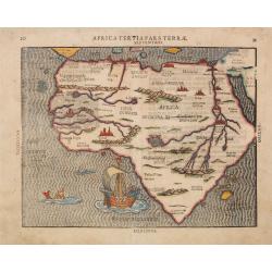
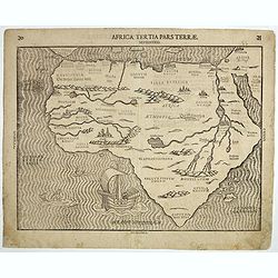
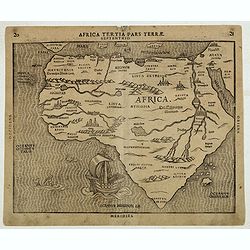
Africa Tertia pars Terrae.
This map of Africa has an unusual shape, tapering to a narrow angle in the south. Numerous rivers appear in West Africa and as tributaries to the Nile, and mountain chain...
Date: Magdeburg, ca1581
Selling price: ????
Please login to see price!
Sold in 2014
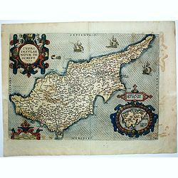
Cypri Insulae Nova descript. 1573.
This is a beautiful copy of a classic map of Cyprus. It is the earliest obtainable version of the best map of Cyprus made to date. Ortelius based his map upon that publis...
Date: Antwerp, 1581
Selling price: ????
Please login to see price!
Sold in 2014
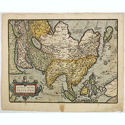
Asiae Nova Descriptio.
Second plate. Ortelius' fine map of Asia well represents the continent at a time when Europeans were expanding their power in the far east. Nova Guinea, with part of the...
Date: Antwerp, after 1581
Selling price: ????
Please login to see price!
Sold in 2016
![Asia secunda pars terrae in forma Pegasi. [Asia is presented as the mythical winged horse Pegasus.]](/uploads/cache/97237-250x250.jpg)
Asia secunda pars terrae in forma Pegasi. [Asia is presented as the mythical winged horse Pegasus.]
An exceptional, most sought after symbolic map of Asia in the form of a Pegasus. In the seas, several sea monsters; many major cities are indicated and named.Bünting's f...
Date: Magdeburg, ca. 1581
Selling price: ????
Please login to see price!
Sold in 2016
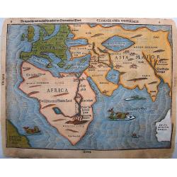
Die eigentliche und wahrafftige Gestalt der Erden und des Meers
A rare map of the world from Heinrich Bünting's "Itinerarium Sacrae Scripturae", famous theological commentary.Some towns named, including Jerusalem, Damascus ...
Date: Magdeburg, ca. 1581
Selling price: ????
Please login to see price!
Sold in 2016
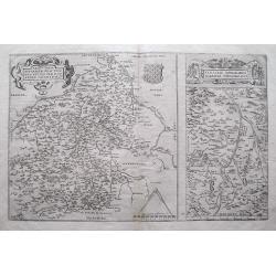
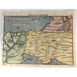
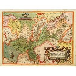
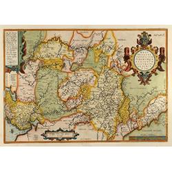
Regionis Biturigum Exactiss: Descriptio per D. Ioannem Calamaeum / Limaniae Topographia Gabriele Symeoneo Auct.
A pair of fine maps on a full folio sheet. The map of Biturigum is centered on Chateau Neuf and Bourges, with the Loire River flowing at the top right of the map to Never...
Date: Antwerp, 1581
Selling price: ????
Please login to see price!
Sold in 2016
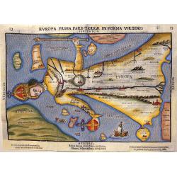
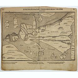
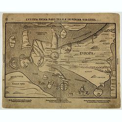
Europa Prima Pars Terrae in Forma Virginis.
In this fascinating map, Europe is depicted in form of a Queen, following the example of Munster's 'Cosmographia'. It is one of the earliest allegorical maps, it appeared...
Date: Magdeburg, after 1581
Selling price: ????
Please login to see price!
Sold in 2017
![TIGVRVM [Zürich]](/uploads/cache/37632-250x250.jpg)
TIGVRVM [Zürich]
One of the finest and most sought-after views of Zürich. From volume one of the greatest publication in this genre!. The Civitates was compiled and written by George Bra...
Date: Cologne, 1581
Selling price: ????
Please login to see price!
Sold in 2018
Africa Tertia pars Terrae.
This map of Africa has an unusual shape, tapering to a narrow angle in the south. Numerous rivers are found in West Africa, as well as tributaries to the Nile, and mounta...
Date: Magdeburg, ca. 1581
Selling price: ????
Please login to see price!
Sold in 2018
![Asia secunda pars terrae in forma Pegasi. [Asia is presented as the mythical winged horse Pegasus.]](/uploads/cache/39170-250x250.jpg)
Asia secunda pars terrae in forma Pegasi. [Asia is presented as the mythical winged horse Pegasus.]
Wood block map of Asia in the form of a Pegasus. The seas are adorned with sea monsters and many major cities are indicated and named. There are several states, of this m...
Date: Magdeburg, c. 1581
Selling price: ????
Please login to see price!
Sold in 2017
Europa Prima Pars Terrae Forma Virginis.
Desirable, famous and relatively scarce-to-rare item usually deemed a curiosity or oddity map. All of Europe is depicted in the form of a Queen wearing her crown and in f...
Date: Magdeburg, ca. 1581
Selling price: ????
Please login to see price!
Sold in 2017
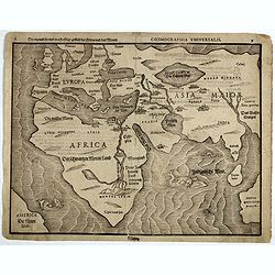
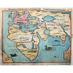
Cosmographia Universalis. . .
Map of the Old World showing a landmass remarkably similar to the west coast of Australia and roughly where Australia should be located. Lower left, an early representati...
Date: Magdeburg, ca. 1581
Selling price: ????
Please login to see price!
Sold in 2017
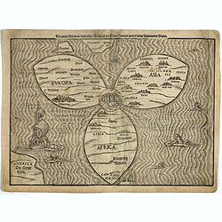
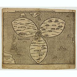
Die gantze Welt in ein Kleberblatt..
This extraordinary curiosity is referred to as the Clover-leaf, for obvious reasons. Heinrich Bünting's design was inspired by the trefoil form of the arms of Hanover, h...
Date: Magdeburg, ca. 1581
Selling price: ????
Please login to see price!
Sold in 2017
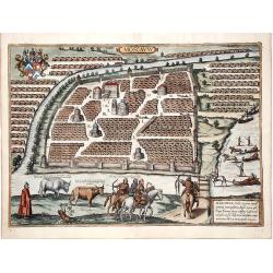
Moscauw - Moscovia, Urbs regionis eiusde nominis metropolitica, duplo maior...
A decorative full color example of Braun & Hogenberg's first view of Moscow, from a slightly elevated viewpoint from across the frozen Moskva River, first published i...
Date: Cologne, 1581
Selling price: ????
Please login to see price!
Sold in 2017
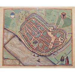
Deventer.
A highly detailed 16th century plan of Deventer, with numerous buildings, streets, places, churches and squares. Further with the city walls and bridges across the river,...
Date: Cologne, ca. 1581
Selling price: ????
Please login to see price!
Sold in 2017
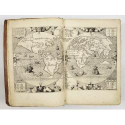
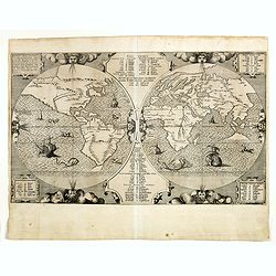
Die eigentliche und wahrafftige Gestalt der Erden und des Meers.
A rare, important map of the world from Heinrich Bünting's "Itinerarium Sacrae Scripturae", a famous theological commentary. Towns named include: Jerusalem, Da...
Date: Magdeburg, ca. 1581
Selling price: ????
Please login to see price!
Sold in 2019
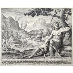
America, sive Bresilia. . .
print of America. By Jan Sadeler after Theodor Bernard.
Date: Amsterdam, ca 1581
Selling price: ????
Please login to see price!
Sold in 2018
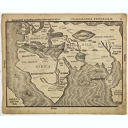
Die eigentliche warhafftige der Erden und des Meers. - Cosmographia Universalis. . .
Map of the old world showing a landmass remarkably like the west coast of Australia and roughly where Australia should be.Lower left an early representation of America, t...
Date: Magdeburg, ca. 1581
Selling price: ????
Please login to see price!
Sold in 2019
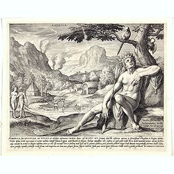
America, sive Bresilia. . .
Allegorical print of the continent of America. Engraved by Jan Sadeler (1550-1601) after Theodor Bernard, dated 1581. Rare print and one of the earliest representations o...
Date: Amsterdam, ca 1581
Selling price: ????
Please login to see price!
Sold in 2020
Die gantze Welt in ein Kleberblatt. . .
This extraordinary curiosity is referred to as the Clover-leaf, for obvious reasons. Heinrich Bünting's design was inspired by the trefoil form of the arms of Hanover, h...
Date: Magdeburg, 1581
Selling price: ????
Please login to see price!
Sold in 2019
Europa Prima Pars Terrae Forma Virginis.
Desirable, famous, and relatively scarce-to-rare items are usually deemed a curiosity or oddity map. All of Europe is depicted in the form of a Queen wearing her crown an...
Date: Magdeburg, ca. 1581
Selling price: ????
Please login to see price!
Sold in 2019
![Asia secunda pars terrae in forma Pegasi. [Asia is presented as the mythical winged horse Pegasus.]](/uploads/cache/44699-250x250.jpg)
Asia secunda pars terrae in forma Pegasi. [Asia is presented as the mythical winged horse Pegasus.]
Wood block map of Asia in the form of a Pegasus. The seas are adorned with sea monsters and many major cities are indicated and named. There are several states, of this m...
Date: Magdeburg c. 1581
Selling price: ????
Please login to see price!
Sold in 2019
Africa Tertia pars Terrae.
This map of Africa has an unusual shape, tapering to a narrow angle in the south. Numerous rivers are found in West Africa, as well as tributaries to the Nile, and mounta...
Date: Magdeburg, ca. 1581
Selling price: ????
Please login to see price!
Sold in 2019
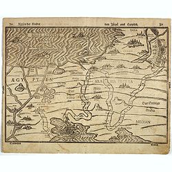
Reisen der Kinder von Israel aus Egypten.
This bold 434-year-old woodblock map illustrates the route taken by the Israelites in the Exodus from Egypt to the Promised Land. The map is very graphic with illustratio...
Date: Magdenburg, 1582
Selling price: ????
Please login to see price!
Sold in 2016
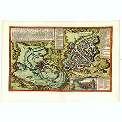
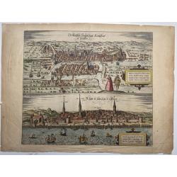
Hierosolymia, Clarissima totius Orientis civitas. . .
Two bird's eye perspectives on one sheet. The left plan shows ancient Jerusalem at the time of Christ. A contemporary view of Jerusalem appears to the right with an attra...
Date: Cologne, 1582
Selling price: ????
Please login to see price!
Sold in 2017
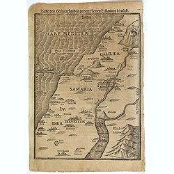
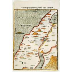
Taffel des Heiligen Landes. . .
An early wood map of the Holy Land. Shows Palestine on both sides of the Jordan at the time of Jesus, divided into Galilee, Samaria and Judea. German text on versoHeinric...
Date: Magdeburg, ca. 1582
Selling price: ????
Please login to see price!
Sold in 2018
Reisen der Kinder Israel aus Egypten.
Travels of the Children of Israel from out of Egypt - is a beautiful late 16th century wood-engraved map.The path of the Israelites is traced starting out at the lower le...
Date: Magdeburg, ca. 1582
Selling price: ????
Please login to see price!
Sold in 2017
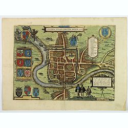
Cestria vulgo Chester, Angliae Civitas.
A stunning town plan of the northern city of Chester, with heraldic shields, Royal and civic coats of arms, explanation table, dividers and Elizabethan figures in the for...
Date: Cologne, ca 1582
Selling price: ????
Please login to see price!
Sold in 2018
![[Title page] Civitates Orbis Terrarum, Liber Primus.](/uploads/cache/43265-250x250.jpg)
[Title page] Civitates Orbis Terrarum, Liber Primus.
Striking allegorical title page, from Volume 1 of Braun & Hogenberg's Civitatus Orbis Terrarum.It shows a façade with a statue of the Magna Mater (Great Mother), the...
Date: Cologne, 1582
Selling price: ????
Please login to see price!
Sold in 2020
![[Title page] Civitates orbis Terrarum.](/uploads/cache/43274-250x250.jpg)
[Title page] Civitates orbis Terrarum.
The most decorative frontispiece of the 1st part of the 'Civitatus Orbis Terrarum'. Flanked by Minerva (or Athena, identified by her owl) named Arcium Inventrix (Founder ...
Date: Cologne, 1582
Selling price: ????
Please login to see price!
Sold in 2019
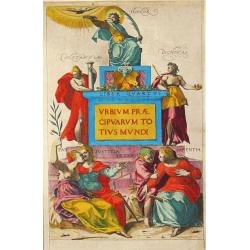
![[Title page] De Praecipuis, Totius Universi Urbibus, Liber Secundus.](/uploads/cache/43275-250x250.jpg)
[Title page] De Praecipuis, Totius Universi Urbibus, Liber Secundus.
Allegorical title page, from Volume 2 of Braun & Hogenberg's Civitatus Orbis Terrarum.At the top are figures representing Religion and Politics, placed on either side...
Date: Cologne, 1582
Selling price: ????
Please login to see price!
Sold in 2022
Dordracum Vulgo Dortt.
Early and detailed panoramic view of Dordrecht, published in the famous ‘Civitates Orbis Terrarum’, by Braun and Hogenberg. Embellished with the royal coat of arms, a...
Date: Cologne, 1582
Selling price: ????
Please login to see price!
Sold in 2019
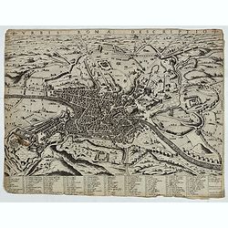
Urbis Romae Descriptio.
First state of three. A rare view of Rome from the Lafreri-School. Below the view there is a numbered legend of 114 references to notable places and monuments, distribute...
Date: Rome, 1582
Selling price: ????
Please login to see price!
Sold in 2019
![Mexico, Regia et Celebris Hispaniae Novae Civitas ... [on sheet with] Cusco, Regni Peru in Novo Orbe Caput.](/uploads/cache/83281-250x250.jpg)
Mexico, Regia et Celebris Hispaniae Novae Civitas ... [on sheet with] Cusco, Regni Peru in Novo Orbe Caput.
An antique map with two bird's-eye views of Mexico City and Cusco (Peru). German text on verso by Braun & Hogenberg.
Date: Cologne, 1582
Selling price: ????
Please login to see price!
Sold in 2019
Hierosolyma, Clarissima Totius Orientis Civitas Iudaee Metropolis . . .
Early map of Jerusalem from Braun&Hogenberg's Civitates Orbis Terrarum, Köln, 1572/1582. Showing two eras of Jerusalem on one map: Jerusalem from the first century o...
Date: Köln, 1572/1582
Selling price: ????
Please login to see price!
Sold in 2020
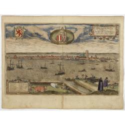
Die Fürstliche Hauptt Statt Königsbergk in Preussen / Die hauptt Statt in Lyfflantt.
A decorative print with two bird's-eye views by Georg Braun & Frans Hogenberg on one sheet: Kaliningrad and Riga.From the greatest publication in this genre!. The pla...
Date: Köln, 1582
Selling price: ????
Please login to see price!
Sold in 2020
AACHEN, Aquisgranum, vulgo Aich, ad Menapiorum fines, perantiqua Imperij Urbs, Monumento Caroli Magni. . .
A fine antique bird's-eye view plan of Aachen by Braun and Hogenberg, after Hendrick Steenwijck, from the Civitates Orbis Terrarum, ... Part 1. Köln, 1572.TRANSLATION OF...
Date: Cologne, 1582
Selling price: ????
Please login to see price!
Sold in 2020
Taffel des Heiligen Landes..
A particularly attractive example of this early wood map of the Holy Land. Shows Palestine on both sides of the Jordan at the time of Jesus, divided into Galilee, Samaria...
Date: Magdeburg 1582
Selling price: ????
Please login to see price!
Sold
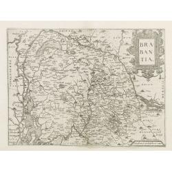
Brabantia.
Map of Brabant from Guicciardini's "Description de touts les Pais-Bais" edited by Plantin in 1582. The map drawn after Ortelius'map of Brabant, and after the...
Date: Antwerp, 1582
Selling price: ????
Please login to see price!
Sold
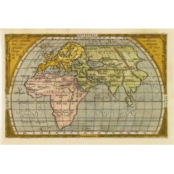
Orbis terrarum hunc typum secundum Pomponii Melae traditionem ? Ab.Ortelius 1582.
From Pomponii Melae De Situ Orbis, miniature world map by Ortelius not showing the Americas and with a decorative border.Ortelius has included the whole of Africa with a ...
Date: Antwerp 1582
Selling price: ????
Please login to see price!
Sold
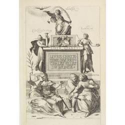
Title page : "Livre quatriesme des principales villes du monde"..
Decorative and finely engraved title page from Braun's Town Book, part 4.
Date: Cologne 1582
Selling price: ????
Please login to see price!
Sold
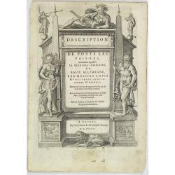
Title page: Descrittione.. di tutti i Paesi Bassi..
Title page from one of the most important travel book of the Low Countries. Architectural border with heraldic figures. In the center the printer's device of the printer ...
Date: Antwerp, 1582
Selling price: ????
Please login to see price!
Sold in 2009
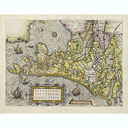
Hollandiae Cattorum regionis typus.
Guicciardini's reduced version of Jacob van Deventer's survey of the province of Holland surveyed in 1537 and published first in Antwerp in nine sheets by Bernard van der...
Date: Antwerp, 1582
Selling price: ????
Please login to see price!
Sold in 2011
Title page: Descrittione.. di tutti i Paesi Bassi..
Title page from one of the most important travel book of the Low Countries. Architectural border with heraldic figures. In the center the printer's device of the printer ...
Date: Antwerp 1583
Selling price: ????
Please login to see price!
Sold
Labore et Constantia.
Printer\'s mark of the Antwerp printer Christopher Plantijn Labore et Constantia. with divider, set in a decorative border with fruits and figures.
Date: Antwerp, 1583
Selling price: ????
Please login to see price!
Sold in 2008
Typus Universalis Terrae, Iuxta Modernorum Distinctionem Et Extensionem Per Regna Et Provincias.
Rare world map from Gregor Reisch's Magarita Philisophica published in Basle in 1583.In 1544, Peter Apian incorporated a world map into his Cosmographia, based upon Gemma...
Date: Antwerp 1583
Selling price: ????
Please login to see price!
Sold
Biblia Sacra.
Famous "Polyglot" Bible, printed by the famous Plantin firm and prepared under the direction of Philip II of Spain. Including a world map well-known for its sho...
Date: Antwerp, 1583
Selling price: ????
Please login to see price!
Sold
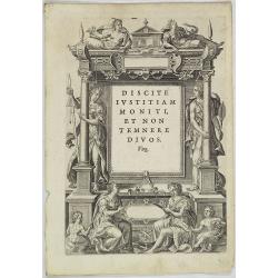
Urbium Praecipuarum Mundi Theatrum Liber Quartus.
Georg Braun and Franz Hoogenberg, published the highly successful "Civitas Orbis Terrarum' in 6 volumes, 1572-1618. It was the first atlas of town views and plans of...
Date: Cologne, 1583
Selling price: ????
Please login to see price!
Sold
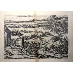
Eigentliche Beschreibung der Schlacht zwischen den Staten und Spaniarden nitt weit von Namur gehaltten.
Representation of the battle of Gembloux, between the Spanish army under Don Juan de Austria and the Dutch troops. In the background the city of Namur. Verso with Latin t...
Date: Cologne, 1583
Selling price: ????
Please login to see price!
Sold in 2013
Benedict Arias Montanus Sacrae Geographiae Tabulam Ex.
World map prepared for the famous "Polyglot" Bible, printed by the famous Plantin firm and prepared under the direction of Philip II of Spain. The world map is ...
Date: Antwerp, 1583
Selling price: ????
Please login to see price!
Sold in 2016
![Die Custe va Lijfflandt, met de Eijlanden daer beneffens also hem dat landt aldaer verthoont en in zyn ghedaente is, van Ekehol.[TALLINN/REVAL,ESTONIA]](/uploads/cache/83566-250x250.jpg)
Die Custe va Lijfflandt, met de Eijlanden daer beneffens also hem dat landt aldaer verthoont en in zyn ghedaente is, van Ekehol.[TALLINN/REVAL,ESTONIA]
A striking full color example of Wagenhaer's map of the north coast of Estonia, Tallinn, including the Gulf of Finland. The map is reversed - showing north at the bottom....
Date: Antwerp, 1583
Selling price: ????
Please login to see price!
Sold in 2021
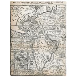
Brevis exactaq totius novi orbis eiusq insularum descriptio recens edita
Woodcut map of the Americas, which was published in three states. The first in Antwerp by Iuan Steelsio in 1554 in “La Historia General de las Indias”, written by the...
Date: Antwerp, 1566, 1567 or 1583
Selling price: ????
Please login to see price!
Sold in 2023
Caroli Sigonii von Geschichten des Königreichs Italiae Fünffsehn Bücher in sich begreiffende die herrliche Historien vom Jahr Christi 57o. anbiß ins 12.oo. Jahr.
Early description of Italy, being the German translation of Carolus Sigonius' "De Regno Italia Libri XV", (Venice, 1574).This German edition published in Strasb...
Date: Bernhart, Strassburg, 1584
Selling price: ????
Please login to see price!
Sold in 2019
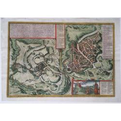
![SOEST [on sheet with] WARBOCH - Warburgum, elegans Westphaliae Opp.](/uploads/cache/84009-250x250.jpg)
SOEST [on sheet with] WARBOCH - Warburgum, elegans Westphaliae Opp.
Two bird's-eye views on one sheet, by Georg Braun and Frans Hogenberg: Soest and Warburg. CARTOUCHE: Soest, among the cities of Westphalia almost the largest and richest....
Date: Cologne, 1584
Selling price: ????
Please login to see price!
Sold in 2020
Aegypti recentior descriptio./ Carthaginis. . .
Two maps on one sheet. Upper part of the sheet (180 x 230 mm) is a map of the northern part of Egypt with the Nile Delta. Many small settlements are dotted along the leng...
Date: Antwerp, 1584
Selling price: ????
Please login to see price!
Sold in 2020
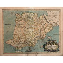
Europae Tabula Secunda (Spain).
This fascinating, large, early copper engraving by Mercator appeared in 1578. It is extremely decorative with a cartouche, a sailing ship and a sea monster in the Mediter...
Date: Cologne, 1584
Selling price: ????
Please login to see price!
Sold in 2021
Europae Tabula septima (Sicily and Sardinia).
A very decorative, large, early map showing Sicily and Sardinia by Mercator. The map first appeared in 1578. Embellished with sailing ships and sea monsters. It shows als...
Date: Cologne, 1584
Selling price: ????
Please login to see price!
Sold in 2022
Circulus Sive Liga Suevia Vulgo Schwabische Kraiss.
Early map showing the region bounded by the Bodensee, the Rhein and Augsburg, centered on the Donau.
Date: Antwerp, ca. 1584
Selling price: ????
Please login to see price!
Sold in 2021
Geographiae libri octo... ac emendatis per Gerardum Mercatorem
Rare second edition of Gerard Mercator's Cl Ptolemaei Alexandrini Geographiae Libri Octo:, printed from the 28 unaltered plates of the 1578 edition (the text on verso ha...
Date: Cologne, G. Kempen, 1584
Selling price: ????
Please login to see price!
Sold in 2025
Belgii Veteris Typus..
A fine map of this historic region with many ancient place names. The map is decorated with 4 cartouches, and a compass rose in the sea. Map is dated 1594
Date: Antwerp 1584
Selling price: ????
Please login to see price!
Sold
Gelriae, Cliviae, Finitimorumque locorum verissima..
East to the top. Fine map of Geldria and Limburg, prepared by Christian s'Grooten. Very fine title cartouche lower right with painters utensils around cartouche.
Date: Antwerp, 1584
Selling price: ????
Please login to see price!
Sold in 2011
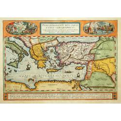
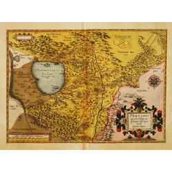
Peregrinatio Divi Pauli Typus Corographicus.
"A splendid map depicting the travels of Paulus. With two fine scenes in top. Showing the countries along the Mediterranean, including Cyprus and Italy. A first edit...
Date: Antwerp 1584
Selling price: ????
Please login to see price!
Sold
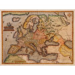
Europae.
Somewhat distorted land masses: vignette of Europe being carried off by the bull (Zeus).The second plate with title AFRICAE PARS now in Italic lettering.
Date: Antwerp 1584
Selling price: ????
Please login to see price!
Sold
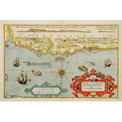
Verthoninghe van de Zee Custen van Bretaignen..
A very decorative chart covering the coast along the coast of Britany. South to the top. A first edition, without the previlegio. Engraved by the master engraver, Johanne...
Date: Amsterdam 1584
Selling price: ????
Please login to see price!
Sold
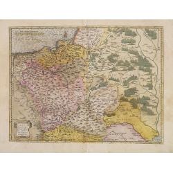
Poloniae, Lituaniaeq descriptio.
Fine general map of Poland, the first plate. Based on the now lost map of Waclaw Grodecki (1588). Shows the Polish kingdom near its greatest territorial limits, stretchin...
Date: Antwerp, 1584
Selling price: ????
Please login to see price!
Sold in 2013
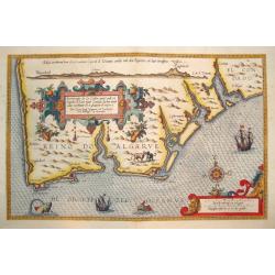
BESCHRIJUINGHE DER ZEE CUFTEN VANT LANT...ARGARBE...
A rarely seen, beautifully rendered and highly decorative sea chart of the Algarve, located in the far south of Portugal.Published in the important 1584 edition of SPIEGE...
Date: Leyden, 1584
Selling price: ????
Please login to see price!
Sold
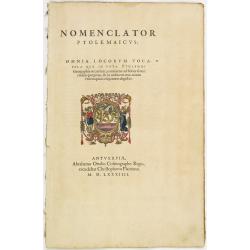
Titlepage: Nomenclator Ptolemaicus..
Not bound but a section of the 1584 atlas, Nomenclator still held together. With dated title page Nomenclator and containing a register of place names in antiquity. In 15...
Date: Antwerp 1584
Selling price: ????
Please login to see price!
Sold
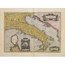
Italiae Veteris Specimen.
Ortelius' map of Ancient Italy which appeared in his beginning in 1584. The map is based upon Gastaldi's map of Italy, supplemented with classical sources. Signed and dat...
Date: Antwerp, 1584
Selling price: ????
Please login to see price!
Sold in 2013
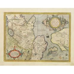
Tartariae sive Magni Chami Regni typus.
Much of the information shown on this map relates to the travels of Marco Polo between 1275 and 1291 with later information gained from the Portuguese Jesuit missionaries...
Date: Antwerp 1584
Selling price: ????
Please login to see price!
Sold
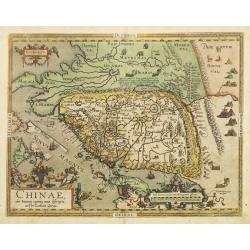
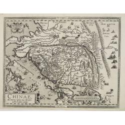
Chinae, olim Sinarum Regionis, nova descriptio. auctore Ludovico Georgio.
The first map of China ever to appear in a Western atlas, west to the top. When this map appeared, it was by far the most accurate one of China.Japan is shown on a curiou...
Date: Antwerp 1584
Selling price: ????
Please login to see price!
Sold
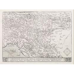
Schlavoniae, Croatiae, Carniale.. Bosniae..
First state. Fine and early map of former Yugoslavia after a map of Hirschvogel (1552-1565) and used by A.Ortelius in his atlas 'Theatrum Orbis Terrarum [Atlas of the Who...
Date: Antwerp 1584
Selling price: ????
Please login to see price!
Sold
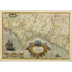
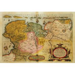
Valentiae Regni, olim contestanorum si ptolemaeo..
Rare issue of this early map of Valencia. According to v.d.Broecke in his book Ortelius Atlas Maps, only very few copies are printed, and only three found so far (1996). ...
Date: Antwerp, 1584
Selling price: ????
Please login to see price!
Sold
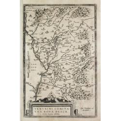
Venuxini Comitatus Nova Descr. Auctore Stephano Ghebellino.
Abraham Ortelius(1527-98), Dutch cartographer and publisher of the first modern atlas, ' Theatrum Orbis Terrarum' in 1570. Editions till 1612. Also an atlas of ancient ca...
Date: Antwerp, 1584
Selling price: ????
Please login to see price!
Sold
Oost ende West Vrieslandte beschryvinghe.
Prepared by Jacob van Deventer. A very decorative map of the Dutch provinces of Friesland, Groningen and Drente and of the German Province of Friesland.
Date: Antwerp, 1584
Selling price: ????
Please login to see price!
Sold in 2008
Perusini agri, exactissima ..
A first imprint. Very fine map centred on the town of Perugia. The map is based on Egnatio Danti's 1580 map of Perugia.Copper engraving with Latin text on verso. Abraham ...
Date: Antwerp, 1584
Selling price: ????
Please login to see price!
Sold in 2008
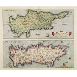
Cyprus Insula / Candia, Olim Creta.
Two maps on one sheet. Copper engraving illustrating Cyprus and Crete, with Latin text on verso. From 1584 onwards editions of the Ortelius atlas no longer included this ...
Date: Antwerp, 1570-1584
Selling price: ????
Please login to see price!
Sold in 2008
Chinae, olim Sinarum regionis, nova descriptio. Auctore Ludovico Georgio.
Engraved map of China with an elaborate baroque title and scale cartouches, galleons and masted land-vehicles. Latin text on verso.This map, drawn by Ludovicus Georgius (...
Date: Antwerp, 1584
Selling price: ????
Please login to see price!
Sold in 2011
Westphaliae Totius, Finitimarumque Regionum Accurata Descriptio
Beautiful hand color copper engraved map of North Rhein-Westphalia by A. Ortelius. From the 1584 Latin edition of \"Theatrum Orbis Terrarum\".
Date: Antwerp, 1584
Selling price: ????
Please login to see price!
Sold in 2009