Browse Listings
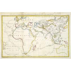
Carte sur laquelle on a tracé la Route des Vaisseaux le Lion et l' Indostan depuis l' Angleterre jusqu'au Golfe de Pékin en Chine
World map shows McCartney's ships' tracks, the Lion, and the Hindustan from England to China. Taken from Volume XXXV of MACARTNEY - BIBLIOTHEQUE PORTATIVE DES VOYAGES, AT...
Place & Date: Paris, Lepetit, 1817
Selling price: $100
Sold in 2011
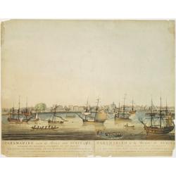
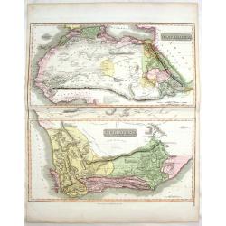
Paramaribo aan de Rivier van Suriname.
Very rare and decorative panoramic view of the city of Paramaribo as seen from the river. The best 19th century view of Paramaribo. The houses shown are typical Dutch in ...
Place & Date: Amsterdam 1817
Selling price: $1000
Sold
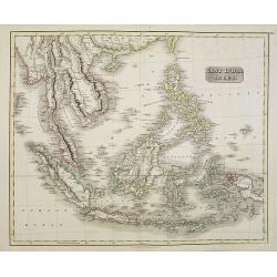
East India Isles.
Somewhat later but very finely engraved and detailed map of the Indonesian archipelago, including Thailand, Philippines and southern part of Taiwan.
Place & Date: Edinburgh 1817
Selling price: $350
Sold
![[No title] From "Journal de la Belgique" Jeudi, 27 Février 1817.](/uploads/cache/22264-250x250.jpg)
[No title] From "Journal de la Belgique" Jeudi, 27 Février 1817.
Lion (45x35mm.) rampant facing right with shield in the right forepaw. In the shield: L'Union fait la Force. 2 vessels and a star are present in the sea. 2 pages of Frenc...
Place & Date: Bruxelles? 1817
Selling price: $525
Sold
![Untitled. [Chart of Zeeland extending as far as Hellevoetsluis]](/uploads/cache/23504-250x250.jpg)
Untitled. [Chart of Zeeland extending as far as Hellevoetsluis]
Right sheet of a 3 sheets, very detailed chart. This half illustrates the seacoast extending from Terneuzen to Hellevoetsluis in the Netherlands.Showing towns, banks and ...
Place & Date: Paris, 1817
Selling price: $680
Sold in 2009
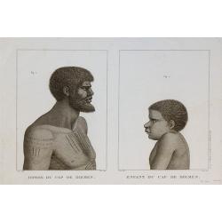
Homme du Cap de Diemen , Enfant du Cap de Diemen
Print taken from the "Atlas pour servir a la relation du voyage a la recherche de la Perouse" published by Dabo.
Place & Date: Paris, 1817
Selling price: $120
Sold in 2010
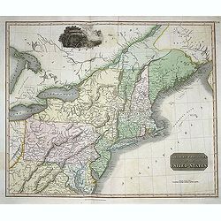
Northern Provinces of the United States.
Somewhat later but very finely engraved and detailed map of the United States.
Place & Date: Edinburgh, 1817
Selling price: $450
Sold in 2008

Femme du Cap de Diemen.
Print taken from the "Atlas pour servir a la relation du voyage a la recherche de la Perouse" published by Dabo.
Place & Date: Paris, 1817
Selling price: $240
Sold in 2010
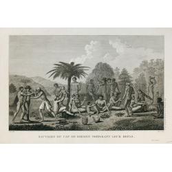
Sauvages du Cap de Diemen préparant leur repas.
Print taken from the "Atlas pour servir a la relation du voyage a la recherche de la Perouse" published by Dabo.
Place & Date: Paris, 1817
Selling price: $100
Sold in 2010
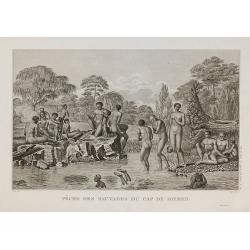
Pêche des sauvages du Cap de Diemen.
Print taken from the "Atlas pour servir a la relation du voyage a la recherche de la Perouse" published by Dabo.
Place & Date: Paris, 1817
Selling price: $100
Sold in 2010
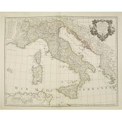
L'Italie dressée sur les observations de l'académie des sciences. . .
Very interesting map of Italy, including Sardinia, Corsica and Sicily. Buache drew heavenly on the work of Delisle. This edition updated for 1817.Philippe Buache de la Ne...
Place & Date: Paris, 1817
Selling price: $240
Sold
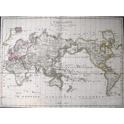
Weltkarte nach den vorzüglichsten Hülfsmitteln und neuesten Entdeckungen verfasst.
Interesting world map in Mercator projection. With many interesting features, such as the source of the Missouri, Indian areas, supposed coasts, New Holland as Australia,...
Place & Date: Vienna, 1817
Selling price: $96
Sold in 2011
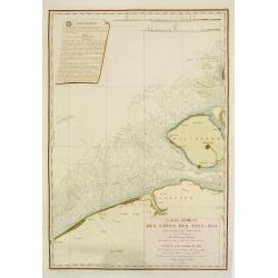
Carte réduite des côtes des Pays-Bas.
repaired by Beautemps-Beaupreé. Covering the coast from Oostende till Hellevoetssluis. Giving exquisite detail with soundings. Upper left large advertisement, upper rig...
Place & Date: Paris, 1817
Selling price: $350
Sold in 2013
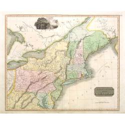
Nothern Provinces of the United States
Somewhat later but very finely engraved and detailed map of eastern part of the United States. Including the states and territories of New England, New York, Pennsylvania...
Place & Date: Edinburgh, 1817
Selling price: $111
Sold in 2013
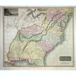
Southern Provinces of the United States
Somewhat later but very finely engraved and detailed map of the United States. Including the states and territories east of the Mississippi River to the Atlantic and as f...
Place & Date: Edinburgh, 1817
Selling price: $250
Sold in 2013
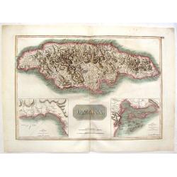
Jamaica.
Fine hand-colored map featuring the island of Jamaica. Inserts of the Harbour of Bluefields and The Harbours of Kingston & Port Royal. From Thomson's "New Genera...
Place & Date: Edinburgh, 1817
Selling price: $26
Sold in 2016
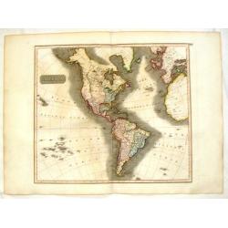
America.
Fine hand-colored, engraved map of North & South America including parts of Europe, Africa and the South Pacific. Includes several geographical mistakes such as Green...
Place & Date: Edinbourgh, 1817
Selling price: $199
Sold in 2015
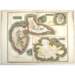
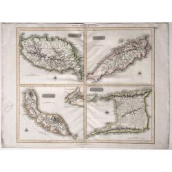
West Indies Islands - Guadeloupe, Mariegalante & Antigua.
A fine Thomson map of the West Indies islands of Guadeloupe, Mariegalante and Antigua. The map is simple, clean and elegant. John Thomson (1777-c1840), was a Scottish ca...
Place & Date: Edinburgh, 1817
Selling price: $115
Sold in 2015
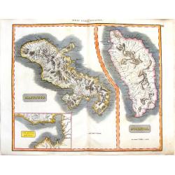
West India Islands - Martinico & Dominica.
Two maps of West India Islands including Martinico and Dominica. Features an inset of cul de Sac Royal (Modern day Fort-de France). Issued in Thomson's "NEW GENERAL ...
Place & Date: Edinburgh, 1817
Selling price: $131
Sold in 2015
North Africa & South Africa.
Large hand-colored map of North & South Africa (two maps on one sheet). The interesting map include details of the locations of historic events, cave paintings and ca...
Place & Date: Edinburgh, 1817
Selling price: $95
Sold in 2017
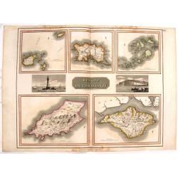
Remote British Islands.
Large, hand-colored map of Great Britain's remote islands including Wight, Scilly, Mann, Guernsey & Jersey. There are also two fine engravings of island scenes.
Place & Date: Edinburgh, 1817
Selling price: $20
Sold in 2016
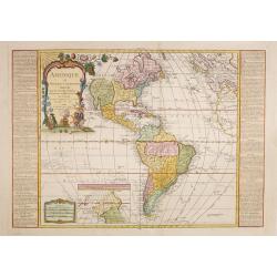
Amérique ou Nouveau Continent Dressée Sur les Nouvelles Relations Découvertes et Observations, par J.B. Nolin. . .
Uncommon map of the Western hemisphere prepared by J.B.Nolin and improved by L.Denis. In the bottom an inset map of continuation of Americas west coast indicating a North...
Place & Date: Paris, (1777) 1817
Selling price: $1000
Sold in 2015
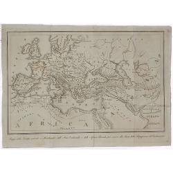
Orbus Veteribus Notus.
Fine map illustrating the ancient world, showing Europe, North Africa & South Asia. Striking vignette of the ruins of ancient Greece. Map by James Wyld, engraved by N...
Place & Date: Edinburgh, 1817
Selling price: $23
Sold in 2014
Russia In Europe - North Part & South Part (Two Maps).
Two fine hand-colored maps of Russia with excellent detail. (North and South Part) The mapmaker was Arrowsmith and they were engraved by Sidney Hall in London in 1817.
Place & Date: London, 1817
Selling price: $125
Sold in 2014
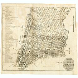
Plan of the City of New York. New-York, Oct. 1817.
Plan de New-York engraved by W. Hooker for "Blunt's Strangers Guide", covering New-York covering Manhattan below 30th Street. Shows some existing and proposed s...
Place & Date: New-York, Oct. 1817
Selling price: $725
Sold in 2014
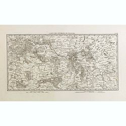
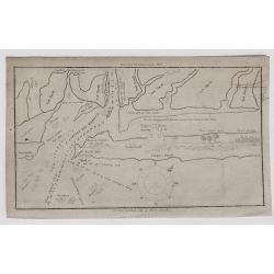
Carte des environs de Polotsk.
Very detailed map taken from the atlas part of the rare work "Mémoires pour servir à L'Histoire de la Guerre entre la France et la Russie, en 1812". Guillaume...
Place & Date: Paris, Barrois L'Aine, 1817
Selling price: $210
Sold in 2015
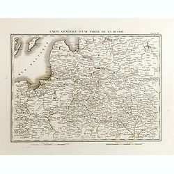
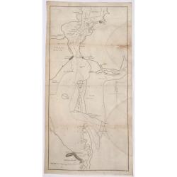
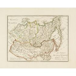
Carte générale d'une partie de la Russie.
Detailed map showing a part of Russia taken from the atlas part of the rare work "Mémoires pour servir à L'Histoire de la Guerre entre la France et la Russie, en 1...
Place & Date: Paris, Barrois L'Aine, 1817
Selling price: $200
Sold in 2015
The Netherlands.
Striking large hand-colored map of The Netherlands. From John Thomson's "New General Atlas",/b> published in 1817. Engraved by J. Moffat.
Place & Date: Edinburgh, 1817
Selling price: $44
Sold in 2018
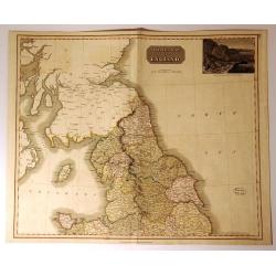
Northern Part of England.
Handsome hand colored map of Northern England, extending as far south as Anglesey. Inset view of ‘The Rope Bridge between the Islands of Holyhead and Anglesey’ at top...
Place & Date: Edinbugh. 1817
Selling price: $15
Sold in 2017
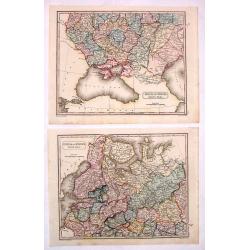
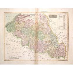
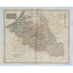
The Netherlands (Belgium and Luxemburg)
A fine map of Belgium and Luxembourg by John Thomson, the Edinburgh cartographer. The title ‘The Netherlands’ refers to the old name for Belgium. The map covers the r...
Place & Date: Edinbourgh, 1817
Selling price: $21
Sold in 2016
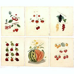
Seven plates from Pomona Britannica.
Seven aquatint and stipple engraved plates of fruits by George Brookshaw (1751-1823) from his "Pomona Britannica, or, a Collection of the most esteemed fruits at pre...
Place & Date: London, Bensley and son, 1817
Selling price: $200
Sold in 2019
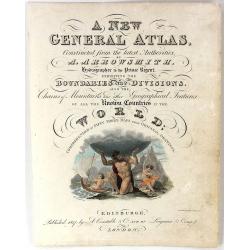
Frontispiece - A New General Atlas
A fine, hand-colored frontispiece for Arrowsmith's "A NEW GENERAL ATLAS", published In 1817 by A. Constable & Co. in London.Map engraved by Charles Heath.
Place & Date: London, 1817
Selling price: $32
Sold in 2016
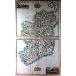
Northern Part of Ireland & Southern Part of Ireland (2 Parts)
This is a striking set of maps of Ireland. Published by John Thomson in Edinburgh in 1817. Essentially two separate maps, the first map (image top) depicts Northern Irela...
Place & Date: Edinburgh, 1817
Selling price: $80
Sold in 2016
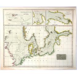
Chart of the North and Baltic Seas
A detailed sea chart of the North Sea & Baltic Sea by John Thomson, the Edinburgh cartographer. This highly detailed chart features soundings, shoals, fishing banks ...
Place & Date: Edinbourgh, 1817
Selling price: $155
Sold in 2019

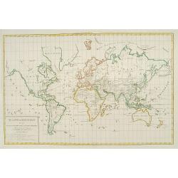
Scandinavia, or Sweden, Denmark & Norway
This fine hand colored map of Scandinavia depicts Sweden, Denmark, and Norway and Finland which was part of Sweden. The map is beautifully engraved in the minimalist Engl...
Place & Date: Edinbourgh, 1817
Selling price: $40
Sold in 2016
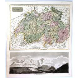
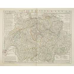
Swisserland
A fine map of Switzerland by John Thomson in 1817. It is divided into two parts, the top part of the sheet covers the Helvetic Confederation of Switzerland, as divided in...
Place & Date: Edinbourgh, 1817
Selling price: $110
Sold in 2019
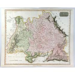
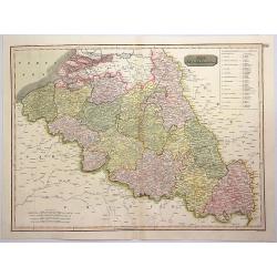
Germany South of the Maine.
A fine map of southern Germany published in Edinburgh in 1817 in Thomson's “New General Atlas”.It is an interesting large format copper engraved antique map of the ea...
Place & Date: Edinbourgh, 1817
Selling price: $117
Sold in 2020
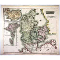
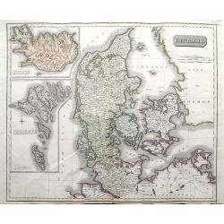
Denmark, Iceland & Feroe Islands.
Very pleasing large engraved map of Denmark by Joun Johnson in Edinbourg in 1817. Features inserts of Iceland and Feroe Islands. John Thomson (1777-1840), was a Scottish...
Place & Date: Edinbourgh, 1817
Selling price: $30
Sold in 2017
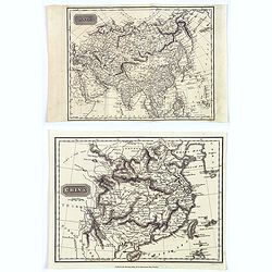
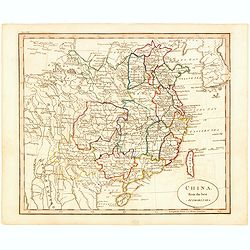
China / Asia.
A pair of maps from the atlas the 'Universal Geography' by Thos. Kelly, and engraved by Finlay. These copper plate maps shows the mainland of China, together with the isl...
Place & Date: London, ca. 1817
Selling price: $30
Sold in 2017
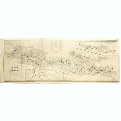
A map of Java chiefly from surveys made during the British administration, constructed in illustration of an Account of Java by T S Raffles . . ,
Rare and detailed map of Java to accompany his monumental two-volume History of Java published in 1817. The topography is particularly well represented, along with the lo...
Place & Date: Java, 1817
Selling price: $875
Sold in 2019
Denmark; Iceland; Feroe Islands.
A double page map of Denmark with inset maps of Iceland and the Faroe Islands.
Place & Date: Edinburgh, 1817
Selling price: $50
Sold in 2020
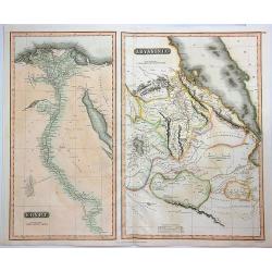
Egypt & Abyssinia.
A fine map of Egypt and Abyssinia by Thomson. It includes two maps on a single sheet, namely, Egypt and Abyssinia.The map of Egypt covers the area from the Nile Delta sou...
Place & Date: Edinbourgh, 1817
Selling price: $30
Sold in 2023
The Netherlands.
A pleasing hand colored 1817 map of Holland by Thomson, engraved in the minimalist English style of the early part of the 19th century. Relief is shown by hachure with to...
Place & Date: Edinbourgh, 1817
Selling price: $25
Sold in 2019
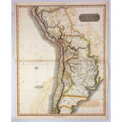
Peru, Chili and La Plata.
A fine 1817 Thomson map of Peru, Chile and Argentina. It also covers parts of Bolivia, Paraguay, Uruguay and Brazil. The map identifies towns, rivers, mountains, indigeno...
Place & Date: Edinbourgh, 1817
Selling price: $17
Sold in 2021
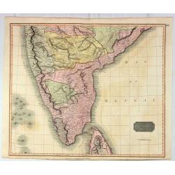
Southern Hindostan.
A fine Thomson regional map of India, extending from Arungabad, Mahoor and Cicacole in the North, to the southern tip of India, including most of Celyon. Highly detailed,...
Place & Date: Edinbourgh, 1817
Selling price: $43
Sold in 2021
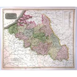
Belgium or the Netherlands.
A striking 1817 map of Belgium and Luxembourg by the Edinburgh cartographer John Thomson. The title ‘The Netherlands’ refers to the old name for Belgium covering the ...
Place & Date: Edinbourgh, 1817
Selling price: $49
Sold in 2018
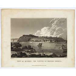
View of Quebec, the Capital of British America.
This is an uncommon view of Quebec, the capital of British America, drawn by W. M. Craig. It features a lovely view of Quebec from across the St. Lawrence. The fortifica...
Place & Date: Liverpool, 1817
Selling price: $55
Sold in 2018
Mappa Della Europa, Asia e Africa per Sevire alla Storia della Propagarione del Cristianesime.
An unusual but simple world map featuring the propagation of Christianity throughout Europe, Asia and North Africa at that time. Bartolomeo Borghi (1750-1821) was an Ita...
Place & Date: Florence, 1817
Selling price: $46
Sold in 2020
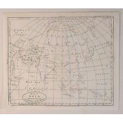
Map of Asia, Shewing the Supposed Situation of Paradise.
An antique copper engraved map, published in 1817, in London for "A Companion to the Holy Bible. . ." by Edward Wells. It was published by C Taylor.Edward Wells...
Place & Date: London, 1817
Selling price: $55
Sold in 2020
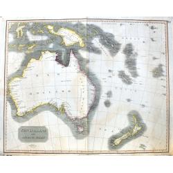
New Holland and Asiatic Isles.
A large and detailed steel engraved map from the Celebes until New Zealand. Includes Fiji, the Solomon islands, Papua New Guinea, Timor, and several small islands with da...
Place & Date: Edinburgh, 1817
Selling price: $85
Sold in 2020
Canada and Nova Scotia.
Engraved by Dassauville. Original hand-color. Issued in the 1817 edition of Thomson's 'New General Atlas'.
Place & Date: Edinburgh: John Thomson. 1817
Selling price: $270
Sold in 2023
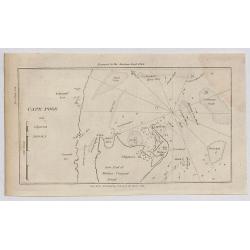
Cape Poge.
A small sea chart showing the eastern portion of Martha's Vineyard. Cape Poge Lighthouse can be seen at the northeast tip of Chapaquedick Island. This map was published ...
Place & Date: New York, 1817
Selling price: $30
Sold in 2020
Little Egg Harbour.
A small sea chart showing Little Egg Harbour east of Tucker's Island.
Place & Date: New York, 1817
Selling price: $12
Sold in 2020
Staten Island.
A small sea chart showing Staten Island, Long Island Bluff and Sandy Hook. This map was published in the “American Coast Pilot”, a detailed guide to harbours, capes a...
Place & Date: New York, 1817
Selling price: $75
Sold in 2020
West India Islands.
Map of four islands in the Caribbean: Grenada. Tobago. Trinidad. Curacao (with) Fort Amsterdam.Title above: 'West India Islands'. At bottom centre: 'Drawn & engraved ...
Place & Date: Edinburgh, London, Dublin, 1816/1817
Selling price: $120
Sold in 2022

Strawberry.
Color aquatint and stipple engraved plate of fruits by George Brookshaw (1751-1823) from his "Pomona Britannica; or, a Collection of the most esteemed fruits at pres...
Place & Date: London, Bensley and son, 1817
Selling price: $60
Sold in 2023

Rasperry.
Color aquatint and stipple engraved plate of fruits by George Brookshaw (1751-1823) from his "Pomona Britannica; or, a Collection of the most esteemed fruits at pres...
Place & Date: London, Bensley and son, 1817
Selling price: $60
Sold in 2023
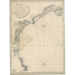
Carte réduite des côtes de France sur la Méditerranée
This masterful and attractive sea chart of the southern coast of France was created by order of the King of France for the Royal Nautical Depository (Dépôt), and bears ...
Place & Date: Paris, 1817
Selling price: $100
Sold in 2023
China, Divided into Its Great Provinces According to the Best Authorities.
The third and final edition of Carey's map of China. One of the most striking differences between maps in this edition vs previous ones is the addition of hatching along ...
Place & Date: Philadelphia, 1818
Selling price: $185
Sold in 2020
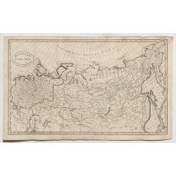
Russian Empire from the Best Authorities.
A detailed map of Russia by Guthrie from “Guthrie’s Geography” published in London in 1818.William Guthrie (1708-1770) Guthrie was born in Brechin in Scotland. He w...
Place & Date: London, 1818
Selling price: $6
Sold in 2020
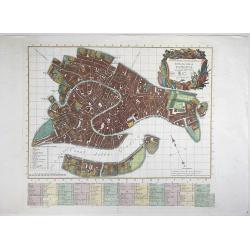
Nuova Pianta Iconografía dell' Inclita Città di Venezia.
A magnificient and decorative copper engraved city map of Venice, engraved and published by Teodoro Viero (1740-1819) in 1818. Based on the plan by Ludovico Ughi plan pub...
Place & Date: Venice, 1818
Selling price: $550
Sold in 2021
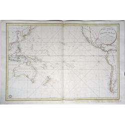
Carte réduite du Grand Ocean compris entre l'Asie et l'Amérique.
Full title: 'Carte reduite du Grand Ocean compris entre l'Asie et l'Amerique, rédigé d'après les observations les plus récentes et publiée pour le Service des Vaisse...
Place & Date: Paris, 1818
Selling price: $450
Sold in 2020
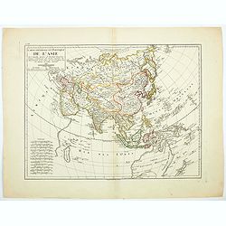
Carte Generale et Politique de L'Asie. . .
Mentelle's political and geographic map of Asia published in 1818, showing the various autonomous regions that comprised Asia. Each region is color coded for ease of iden...
Place & Date: Paris, 1818
Selling price: $68
Sold in 2020
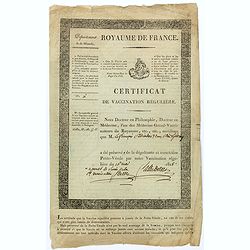
Certificat de vaccination régulière, N°61 (Certificate of regular vaccination).
Certificate of regular vaccination against smallpox, issued by a Doctor of Philosophy and Medicine in the "Département de la Manche" (Normandy).Smallpox vaccin...
Place & Date: 16th May, 1818
Selling price: $300
Sold in 2022
Mappamondo per usi dei viaggi di Marco Polo, e di Altri Veneziani.
Rare world map according to Mercator?s Projection by P.Ab. Zurla. The tracks of Marco Polo, Antoni Zeni, Nicolo Conti, Cabot, etc. are indicated.Full outline for Australi...
Place & Date: Italy 1818
Selling price: $425
Sold
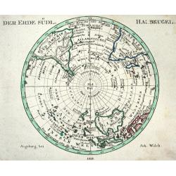
DER ERDE SÜDL. HALBKUGEL
Nice map of the Southern Hemisphere, centered on the South Pole with well shaped Australia. Only a small fraction of Antarctica is indicated.
Place & Date: Augsburg, 1818
Selling price: $60
Sold
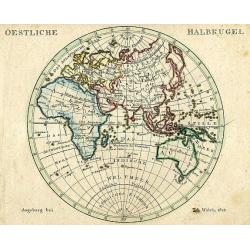
OESTLICHE HALBKUGEL
Well engraved German map of the Eastern Hemisphere including Australia. Accurately shaped continents mostly correctly placed Islands.
Place & Date: Augsburg, 1818
Selling price: $60
Sold in 2008
Carte de la ville de constantinople et du Bosphore de thrac.
Detailed map of the river Bosporus, with Istanbul and the Black Sea. Text in Greek. Engraved by S.I. Neele and Son.
Place & Date: London, ca. 1818
Selling price: $650
Sold in 2008
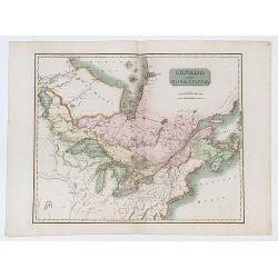
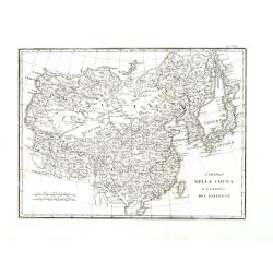
La Siberia o sia Russia Asiatica e la Tartaria Cinese . . .
Rare regional map of the region between Kamtchatka and I Jesso to the Ural Mountains, centered in Irkutsck. Extends to Tibet, Mongolia, Korea etc. Map from the most impor...
Place & Date: Florence, 1818
Selling price: $150
Sold in 2014
Carte de Suise ou sont les Cantos de Zurich Berne . . .
Very interesting map of Switzerland, colored in outline. Along the top 26 coats of arms of the diverent cantons. Buache drew heavenly on the work of Delisle. This edition...
Place & Date: Paris, 1818
Selling price: $180
Sold
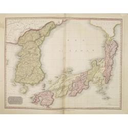
Japan.
This is an extremely fine mapping of Japan and Korea from the scarce American edition of Pinkerton's Modern Atlas, published by Thomas Dobson & Co. of Philadelphia in...
Place & Date: Philadelphia, 1818
Selling price: $250
Sold in 2010
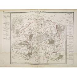
Departement de la Seine et de l'Oise.
Detailed map centered on Paris. Taken from "Atlas national de France", the first atlas with the departments of France published by Pierre Grégoire Chanlaire.
Place & Date: Paris, P.G. Chanlaire, 1818
Selling price: $60
Sold
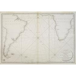
Carte réduite de l'océan Atlantique méridional. . .
Map showing the southern part of South America and Africa, including the Falkland islands. Issued by "Depot Général de la Marine", the official French Governm...
Place & Date: Paris, 1818
Selling price: $100
Sold in 2011
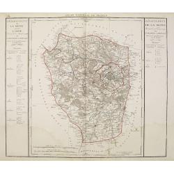
Departement de Paris en 12 Justices de Paix et 12 Maires.
Detailed map centered on Paris. Taken from "Atlas national de France", the first atlas with the departments of France published by Pierre Grégoire Chanlaire.
Place & Date: Paris, P.G. Chanlaire, 1818
Selling price: $120
Sold
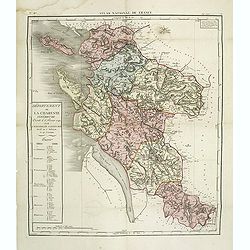
Département de la Charente inférieure decreté le 6 février 1790. . .
Map of region of west of France. Region of Charente inférieure divided into 7 districts. explicative text with the division of the districts and cantons.Sheet No. 38 fro...
Place & Date: Paris, 1790-1818
Selling price: $160
Sold
A CHRONOLOGICAL HISTORY OF VOYAGES INTO THE ARCTIC REGIONS; Undertaken Chiefly for the Purpose of Discovering a North-East, North-West, or Polar Passage Between the Atlantic and Pacific. BARROW, JOHN
First Edition. Barrow, second secretary to the Admiralty, was one of the prime instigators of the renewal of arctic exploration in the nineteenth century. With Banks and ...
Place & Date: London - New York, 1818
Selling price: $500
Sold in 2014
L\'Impero della China e l\'impero del Giappone.
Scarce regional map of China, Korea and Japan.Map from the most important Florentine atlas. Bartolomeo Borghi (1750-1821) as “one of the greatest geographers of Europe....
Place & Date: Florence, 1818
Selling price: $81
Sold in 2013
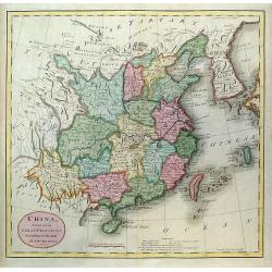
China from the best Authorities.
China from Guthrie's Geography. Engraved by John Russell.
Place & Date: London, 1818
Selling price: $90
Sold
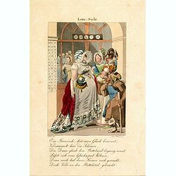
Lotto Sucht.
Engraved by Joseph Stöber, (born in Vienna 13. June1768, died 12 March1852) after design of Matthäus Loder (1781-1828). From Castelli, "Zerrbilder menschlicher Tor...
Place & Date: Wien, 1818
Selling price: $150
Sold in 2014
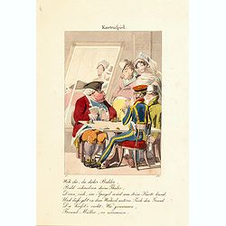
Kartenfpiel.
Engraved by Joseph Stöber, (born in Vienna 13. June1768, died 12 March1852) after design of Matthäus Loder (1781-1828). From Castelli, "Zerrbilder menschlicher Tor...
Place & Date: Wien, 1818
Selling price: $150
Sold in 2014