Browse Listings
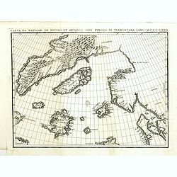
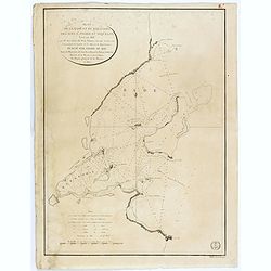
Carta da navegar de Nicolo et Antonio Zeni Furono in Tramontana Lano MCCCLXXX.
An early 19th-century example of Nicolo Zeno's map of the North Atlantic, based upon the legend of a 14th Century Venetian Zeno family and their reported travels to the N...
Place & Date: Venice, 1818
Selling price: $500
Sold in 2016
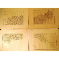
La Bassa Germania (4 Maps)
Four rare maps from "Atlante Geografico" by the priest Bartolomeo Borghi. This was considered as the most important Florentine atlas. The four maps are hand mar...
Place & Date: Florence, 1818
Selling price: $1
Sold in 2015
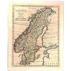
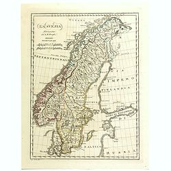
La Svezia Norissima.
A fine detailed map of Sweden
Place & Date: Florence, 1818
Selling price: $11
Sold in 2016

A View of West-Point on the River Hudson, With the Steam-Boat, invented by M. Fulton, going up from New-York to Albany.
A lithographic incunabula showing a view of West-Point on the River Hudson, with the Steam-Boat, invented by M. Fulton, going up from New-York to Albany. Lithograph after...
Place & Date: Dijon, 1818
Selling price: $4500
Sold in 2016

Proof state without title. (A View of West-Point on the River Hudson, With the Steam-Boat, invented by M. Fulton, going up from New-York to Albany.)
A lithographic incunabula showing a view of West-Point on the River Hudson, with the Steam-Boat, invented by M. Fulton, going up from New-York to Albany. Lithograph after...
Place & Date: Dijon, 1818
Selling price: $2500
Sold in 2016
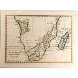
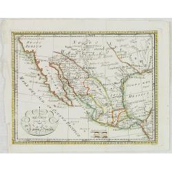
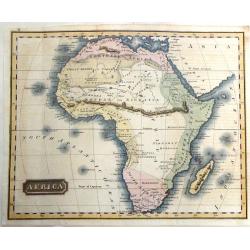
L'Africa Meridionale.
A fine map of southern Africa and Madagascar, by Borghi, from his atlas "Atlante Geograpfico". Bartolomeo Borghi (1750-1821) was an Italian cartographer, engrav...
Place & Date: Florence, 1818
Selling price: $100
Sold in 2017
![Music. [Two sheets].](/uploads/cache/37270-250x250.jpg)
Music. [Two sheets].
Two pages with musical instruments and monkeys from "Encyclodedia Londenensis". Engraved by J.Pas.
Place & Date: London, 1818
Selling price: $25
Sold in 2019
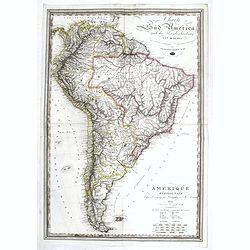
Amerique Meridionale d'apres le voyage au Paraguay de M. Azara.
A large uncommon folding map of South America, with both German and French titles and explanations, by Jospeh Dirwald, published in Vienna in 1818. The map is probably ba...
Place & Date: Vienna, 1818
Selling price: $200
Sold in 2017
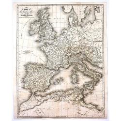
A Map of the Western Part of the Roman Empire.
Interesting map of the western Roman Empire in Europe with both the current names and ancient names. By Sidney Hall and published by Longman, Hurst et al. in London in 18...
Place & Date: London, 1818
Selling price: $30
Sold in 2017
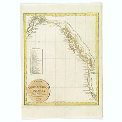
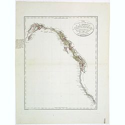
Charte von der Nordwestkuste Americas Nach Vancouver.
An anonymous 1818 'Charte von der Nordwestkuste Americas nach Vancouver'. This map of the Pacific coast stretches from present-day San Francisco north to Anchorage, in Al...
Place & Date: Prague, 1818
Selling price: $70
Sold in 2017
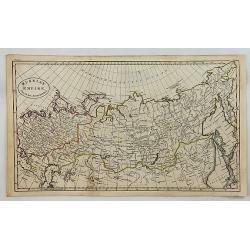
Russian Empire from the Best Authorities.
A fine copper engraved map of the Russian Empire, published in “An Atlas to Guthrie's Geographical Grammar” published in London in 1818.
Place & Date: London, 1818
Selling price: $19
Sold in 2018

Third and Improved Edition of The Present State of Europe, With Maps of the Territories, as Settled by the Congress of Vienna.
A rare broadside printed on two sheets, showing the political changes of Europe between 1783 and 1818. With 14 inset maps, some with their flags. Extensive text about eac...
Place & Date: Derby, ca 1818
Selling price: $107
Sold in 2018
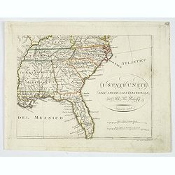
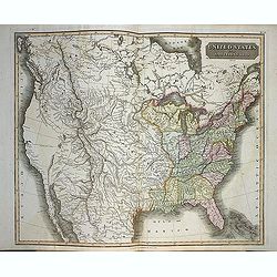
I Stati Uniti nell' America Settentrionale.
Only one sheet of four.The south eastern section of Bartolomeo Borghi's scarce 4 sheet map of the United States. From east of the Mississippi River. From: Kentucky and so...
Place & Date: Firenze, 1818
Selling price: $85
Sold in 2019
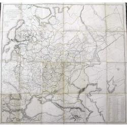
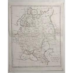
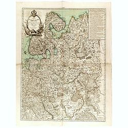
Carte de la Partie Européenne de l'Empire de Russie...
Uncommon and impressive large map of European Russia. Extends from the White Sea until the Black Sea in the South, and the Baltic Sea in the west to the Caspian Sea in th...
Place & Date: St. Petersburg, 1818
Selling price: $70
Sold in 2019

Interesting views in Turkey selected from the original drawings, taken for Sir Robert Ainslie, with descriptions historical and Illustrative.
The rare 8vo. edition was re-engraved to a smaller size, from Mayer's Views in the Ottoman dominions, 1810. The 8vo edition has 16 handcolored superb English aquatints of...
Place & Date: London, Robert Bowyer, 1819
Selling price: $1100
Sold in 2015
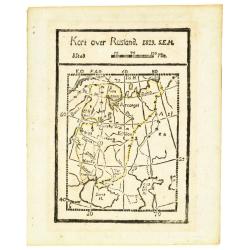
Kort over Rusland 1819 S.E.H.
Rare wood block printed map of European part of Russia, including Finland.
Place & Date: Denmark, 1819
Selling price: $50
Sold in 2013
Mappa Dioecensis Alba-Regalensis . . .
Rare two sheet map of Albensis in Hungary, pre pared by Janor Pongratz, who was an Hungarian engraver and military cartographer and served as a lieutenant in the second R...
Place & Date: Budapest, ca. 1819
Selling price: $500
Sold in 2018
Plan de la Rade et du Barachois..
Sea of Rade de Saint-Denis le Barachois on the island La Réunion. Relief shown by hachures. Depths shown by soundings. Below engraved seal of Depot General de la Marine...
Place & Date: Paris, 1819
Selling price: $50
Sold in 2018
La Svezia Norissima.
A detailed map of Sweden and Norway from the rare "Geographic Atlas" by Borghi. Abbot Bartolomeo Borghi (1750-1821), was a cartographer, engraver and publisher....
Place & Date: Florence, 1819
Selling price: $50
Sold in 2018
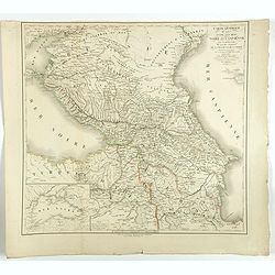
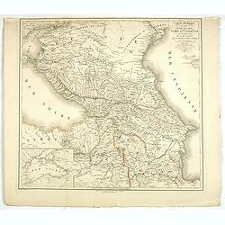
Carte générale du pays entre les mers Noire et Caspienne, avec la désignation des nouvelles frontières de la Russie et de la Perse. . .
A stunning map of Georgia, Armenia, and Azerbaijan.
Place & Date: Paris, 1819
Selling price: $65
Sold in 2018
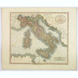
A New Map of Italy. . .
An attractive and beautifully engraved map of Italy by English cartographer John Cary, published in London in 1819. The map shows the country divided into its many duchie...
Place & Date: London, 1819
Selling price: $80
Sold in 2020
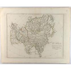
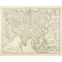
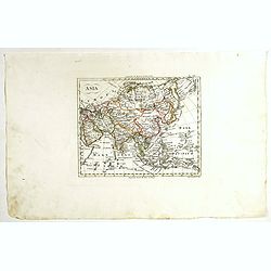
L'Asia Con Scoperte Fatte Nella Persia Orientale, e Interno all'Indo Dagli. . .
An interesting map of Asia with Discoveries Made in Eastern Persia, and Inside the Indus Dagli by Borghi in 1819. Engraved by Studio GuerraBartolomeo Borghi (1750–1829)...
Place & Date: Florence, 1819
Selling price: $7
Sold in 2021
A Map of the Present Seat of War in the North of Europe.
A striking, detailed, uncommon and large, 1819 Laurie & Whittle's copperplate map of European Russia, at the time of the French Invasion of Russia. It extends to cove...
Place & Date: London, 1819
Selling price: $250
Sold in 2021
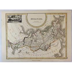
Russia in Asia.
An interesting map Russian Asia, mainly that of Siberia. It extends from Europe to the NW coast of America. Features a decorative vignette of a winter scene with sled and...
Place & Date: Edinburgh, 1819
Selling price: $65
Sold in 2019
Neuester strom der zeiten oder bildliche Darstellung der Weltgeschichte von den ältesten zeiten bis zum ende des achtzehnten jahrhunderts
Very large historical chart composed of three joined sheets giving an broad overview of the development of the history during the centuries. Prepared by Friedrich Strass ...
Place & Date: Vienna, 1819
Selling price: $350
Sold in 2019
Carte générale du pays entre les mers Noire et Caspienne, avec la désignation des nouvelles frontières de la Russie et de la Perse. . .
A stunning map of Georgia, Armenia, and Azerbaijan. Area of coverage extends from the Black Sea to the Caspian Sea. This beautifully rendered map is truly a masterpiece o...
Place & Date: Paris, 1819
Selling price: $190
Sold in 2020
Russia Europea.
Detailed example of Bartolomeo Borghi’s 1819 engraved map of the Russian Empire in Europe. Includes Russia, Ukraine, Crimean Peninsula, Finland, Poland, Lithuania, Lat...
Place & Date: Florence, 1819
Selling price: $5
Sold in 2023
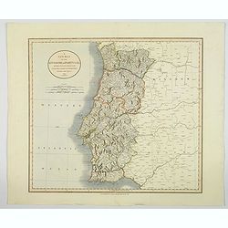
A New Map of the Kingdom of Portugal.
A fine and detailed map of Portugal by John Cary, with the various provinces in pale wash color. Showing mountains, roads, rivers and numerous village and towns. Interest...
Place & Date: London, 1819
Selling price: $65
Sold in 2020
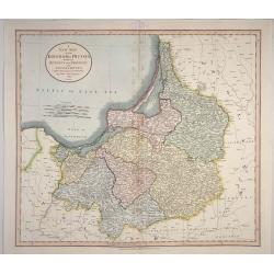
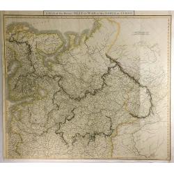
A New map of the Kingdom of Prussia. . .
A New map of the Kingdom of Prussia with its Divisions into Provinces and Governments. Accurate map of Prussia which is now northern Poland and Lithuania. With title at t...
Place & Date: London, 1819
Selling price: $12
Sold in 2023
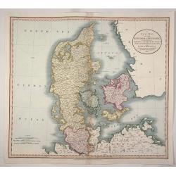
A New map of the Kingdom of Denmark, Comprehending North and South Jutland, Zeeland, Fyen, Laaland, and Part of Holstein.
An accurate map of Denmark by John Cary who was considered 'the most representative, able and prolific of English cartographers'. Tooley says, 'As an engraver he was eleg...
Place & Date: London, 1819
Selling price: $33
Sold in 2020
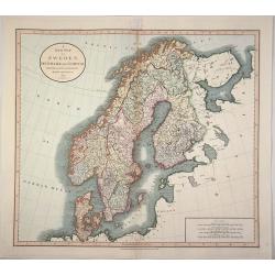
A New Map of Sweden, Denmark and Norway from the Latest Authorities.
An accurate map of Scandinavia by John Cary who was considered 'the most representative, able and prolific of English cartographers'. Tooley says, 'As an engraver he was ...
Place & Date: London, 1819
Selling price: $53
Sold in 2020
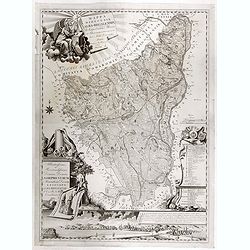
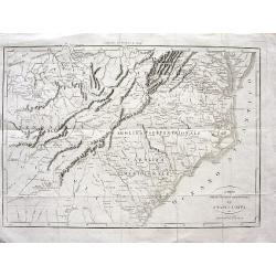
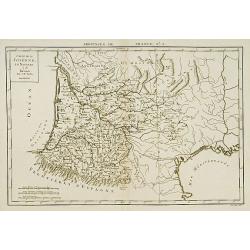
Carta delle provincie meridionali degli Stati-Uniti.
An Italian map of the south eastern United States from Botta's Storia della Guerra dell' Independenza degli Stati Uniti d'America, which was based upon Francois la Rochef...
Place & Date: Milan, ca 1819
Selling price: $100
Sold in 2020
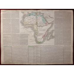
Pianta della Fortezza di Rosas colle opere di assedio eseguite nel 1808.
Map of Africa made for I.M.F. Schmidt, for "Ritter Erdkunde". Published by S.Schropp & Company. Some interesting hypotatical details. A color key in lower p...
Place & Date: Berlin, 1819
Selling price: $150
Sold in 2020
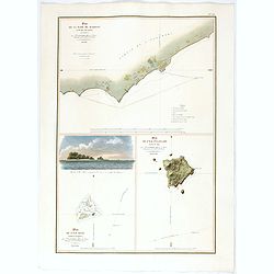
Plan De La Rade De Raheina sur l'Ile Mowi (Iles Sandwich).
Exceedingly rare plan of Lahaina and its anchorages, the earliest obtainable map of Maui based upon actual surveys.This coastal charting of Lahaina, Maui, "Plan de l...
Place & Date: Paris, 1819
Selling price: $1400
Sold in 2022
Carta delle provincie meridionali degli Stati - Uniti
Interesting map from the Italian translation of Francois La Rochefoucauld-Liancourt's famous travel guide for the United States. Showing the Carolinas, Georgia, Tennessee...
Place & Date: Italy, 1819
Selling price: $200
Sold in 2008
![Untitled. [Villefranche-sur-Mer]](/uploads/cache/90633-250x250.jpg)
Untitled. [Villefranche-sur-Mer]
Rare manuscript map of Villefranche-sur-Mer near Nice in southern France. Includes Mont Boron (here called Monboroni) and the peninsula of Saint-Jean-Cap-Ferrat. Finely e...
Place & Date: France, 1819
Selling price: $350
Sold in 2008
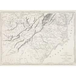
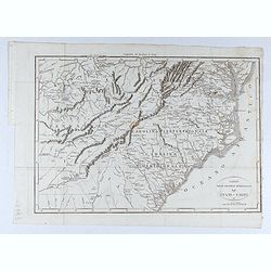
Carta delle provincie meridionali degli Stati - Uniti.
An interesting map from the Italian translation of Francois La Rochefoucauld-Liancourt's famous travel guide for the United States.Showing the Carolinas, Georgia, Tenness...
Place & Date: Italy, 1819
Selling price: $120
Sold in 2023
Carte d'Allemagne dressée sur les observations Astronomiques et Géographiques. . .
Uncommon map published by Dezauche after G. de l'Isle however updated according to the Treaty of Paris of 1815, which was signed on 20 November 1815 following the defeat ...
Place & Date: Paris, 1819
Selling price: $50
Sold in 2019
Carte d'Asie Dressée pour l'instruction. . .
The map is a rare updated version of the Delisle-Buache map of 1762. Detailed map of Asia with inset map of Siberia but now the east coast of America with the "Nord-...
Place & Date: Paris, J.Dezauche, 1819
Selling price: $500
Sold in 2010
Atlante generale dell Ab. Bartolomeo Borghi nella Stamperia Granducale Firenze 1819.
One of the most important aspects of the atlas is that it incorporated the new geo-political contours of Europe decided upon at the Congress of Vienna held at the end of ...
Place & Date: Florence, 1819
Selling price: $9000
Sold

Set of 8 views from 'Source of the Thames'
Lovely set of seven highly attractive engraved views and the titlepage, by Cooke from his "Source of the Thames". The very decorative views, include much detail...
Place & Date: London, 1819
Selling price: $65
Sold in 2011

Le Merisier a Fruits Rouges.
An attractive representation of a wild cherry tree by Pierre-Antoine Poiteau (1766-1854), wellknown from his Pomologie Française (1838). This print is from Histoire natu...
Place & Date: Paris 1818-1820
Selling price: $60
Sold

Coiffures ornée de gaze-velours.. (1872)
From Costume Parisien (1797-1839).Paris was the capital for fashion innovation and design. After the final defeat of Napoleon, English and French fashions merged to close...
Place & Date: Paris 1820
Selling price: $10
Sold
Carte de la Guienne, de la Navarre et du Bérn.
A detailed map of Guienne and Gascoigne. Engraved by Vallet.
Place & Date: Paris, 1820
Selling price: $74
Sold
La France au commencement de la 3.eme Race..
UNIQUE: with paragraph of the creator of the map Adrien Hubert Brué (1786-1832). The map is a proof with color corrections marked in brown ink by Adrien Hubert Brué.
Place & Date: Paris 1820
Selling price: $180
Sold in 2010
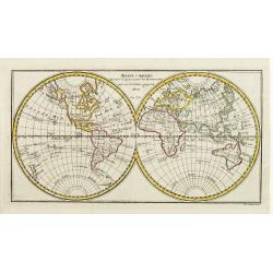
Mappe-monde Dessinée d'après toutes les Découvertes qui ont été Faites jusqu'en 1800. Par l'A.M. ..
Double hemispherical map of the world showing discoveries to 1800. Engraved by Ph. J. Maillart.
Place & Date: Paris ca 1820
Selling price: $100
Sold
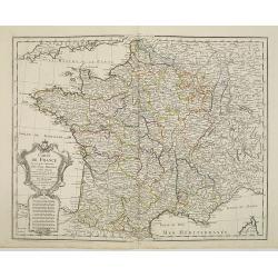
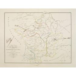
Carte de France.
Detailed map of France, with an updated date of "An 9" 1820 in the large allegoric title cartouche with a detailed title and dedication to the famous French car...
Place & Date: Paris, 1820
Selling price: $90
Sold

LIMA, por el Lado del este.
Very fine view of Lima, engraved by T.Sutherland. The engraving was made after a design of Paroissein.Showing the Rímac River and is the most important source of potable...
Place & Date: London, 1820
Selling price: $100
Sold in 2008

Place de la Foire à Venise.
Basset was a well-known publisher of optical prints, established in rue St Jacques in Paris. In the 18th century the optical print or vue d'optique came into existence, w...
Place & Date: Paris, c.1820
Selling price: $60
Sold in 2010

Vue de la Cathédrale de Milan
Basset was a well-known publisher of optical prints, established in rue St Jacques in Paris. In the 18th century the optical print or vue d'optique came into existence, w...
Place & Date: Paris, c.1820
Selling price: $40
Sold in 2011

Vue du pont de Rïalto à Venise.
Basset was a well-known publisher of optical prints, established in rue St Jacques in Paris. In the 18th century the optical print or vue d'optique came into existence, w...
Place & Date: Paris, c.1820
Selling price: $60
Sold in 2010

Vue de la grande rue et du château à Edimbourg
Optical print of the Caste of Edinburgh. Basset was a well-known publisher of optical prints, established in rue St Jacques in Paris. In the 18th century the optical prin...
Place & Date: Paris, c.1820
Selling price: $60
Sold in 2008
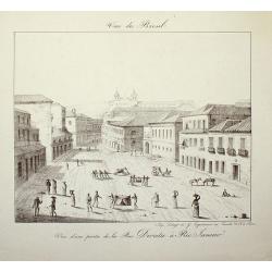
Vue du Bresil - Vue d'une partie de la Rue Direita à Rio-Janeiro
Place & Date: Paris, c. 1820
Selling price: $120
Sold in 2008
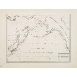
Partie septentrionale de l'Océan Pacifique ou l'on marqué les découvertes et les routes de M.rs de la Pérouse et Cook.
Detailed and rare map of the northern part of the Pacific with the Gulf of Alaska, British Columbia, south to St.Francisco and the east coast of Asia from Tartary to Kore...
Place & Date: Paris, 1820
Selling price: $150
Sold in 2011
Carte de la partie de la cote nord-ouest de l'Amerique. Reconnue pendant les Etes de 1792, 1793 et 1794 depuis 29054' de latitude nord et 244033' de. . .
Detailed and rare map of the Gulf of Alaska, British Columbia, south to St.Francisco.Prepared by Edward Roberts after information by George Vancouver. Engraved by Tardieu...
Place & Date: Paris, 1820
Selling price: $150
Sold in 2011
Messico Nuova Spagna.
Rare map of Mexico and Texas. Engraved by Pasquali.
Place & Date: Italy, c.1820
Selling price: $100
Sold in 2023
United States and additions, 1820
In this map showing the United States from coast to coast, John Thomson offers significant detail with rivers, mountains and Indian villages. Transmississippi West is tru...
Place & Date: Edinburgh, 1820
Selling price: $700
Sold in 2013
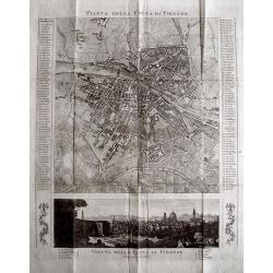
PIANTA DELLA CITTÀ DI FIRENZE.
Rare copper engraved city map of Florence. Extremely detailed plan showing buildings, piazzas, and naming 186 streets in side panels! Below with a view of the city taken ...
Place & Date: c1820
Selling price: $51
Sold in 2013

An old English gentleman pester'd by servants wanting places.
Unusual caricature etching after James Gillray. Published by John Miller, Bridge Street & W. Blackwood, Edinburgh. Hardly seen on the market, similar to Lot 45 at th...
Place & Date: London, c1820
Selling price: $45
Sold in 2013
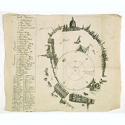
Panorama London.
A separately published key sheet for Robert and Henry Aston Barker’s ‘Panorama of London painted as if viewed from the roof of Albion Mills on the South Bank,’ and ...
Place & Date: London ?, ca. 1820
Selling price: $300
Sold in 2017
Carte générale de l'Empire de Russie comprise en Europe, pour l'intelligence de la guerre présente entre l'Impératrice de toutes les Russies et le Turc. . .
Rare and detailed two-sheet map of European Russia, Finland, Lapland and Baltic States with an ornamental title cartouche in the upper left corner. Prepared by Maurille A...
Place & Date: Paris, ca. 1820
Selling price: $1500
Sold in 2014

Ch'onhado (Map of the world beneath the heavens)
The Ch'onhado, literally "Map of the world beneath the heavens"), or sometimes Cheonha jeondo, literally "Complete map of the world beneath the heavens), i...
Place & Date: Korea, ca 1820
Selling price: $1700
Sold in 2014
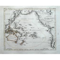
Grande Oceano ouvero Quinta Parte del Mondo.
Curious engraved map of the Pacific ocean. Extends from China to the Hudson Bay. With an interesting depiction of Australia and numerous islands in the Pacific including ...
Place & Date: Milan, ca. 1820
Selling price: $85
Sold in 2014
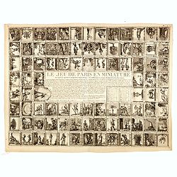
A fine collection of 10 printed game boads, some with cartographical subjects.
The most common game-play set up, used in board games even today, comes from an Italian game known as Goose, which originated in the late 1500s. This game, popular all ov...
Place & Date: Several publishers, 1660 - 1820
Selling price: $8600
Sold in 2014
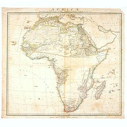
Africa.
Fine hand-colored map of Africa by Sidney Morse. It was published by Richardson & Lord in Boston in 1820. It came from the atlas to "MORSE'S SCHOOL GEOGRAPHY&quo...
Place & Date: Boston, 1820
Selling price: $65
Sold in 2015
Mappe-Monde en deux Hemisphere cartes.
Uncommon world map in double hemisphere centered on Australia and New Zealand. Prepared by H.Brué and published in his "Atlas Universel".
Place & Date: Paris, 1820
Selling price: $50
Sold in 2015
L'AFRIQUE ACTUELLE AVEC LES RENSEIGNEMENTS ET DECOUVERTES OBTENUS PAR LES DERNIERS VOYAGEURS
An interesting map of Africa set in a large page of descriptive text from "Geographie de L’Afrique" printed in Paris by Paul Renouard.
Place & Date: Paris, 1820
Selling price: $100
Sold in 2015

Vue du Palais de la Bourse.
Optical view of the stock exchange in Paris. In the eighteenth and nineteenth centuries there were many popular specialty establishments in Paris, Augsburg and London, wh...
Place & Date: Paris, ca. 1820
Selling price: $26
Sold in 2019

George Washington.
Rare lithographed portrait of George Washington, by an unknown artist; published by William Smith, 702 So. Third St, Philadelphia.Surrounded by scroll work.
Place & Date: Philadelphia, c1820
Selling price: $100
Sold in 2016

Chungguk-do
Chungguk-do [Map of China] prominently depicting the Great Wall and the Yellow and Yangtze rivers.
Place & Date: Korea, ca. 1820
Selling price: $1400
Sold in 2015
A Map of the Western Part of the Roman Empire
An interesting map of Europe and North Africa during the time it was ruled by the Roman Empire. The names are those as used during that time of occupation. Published by T...
Place & Date: London, 1820
Selling price: $8
Sold in 2016
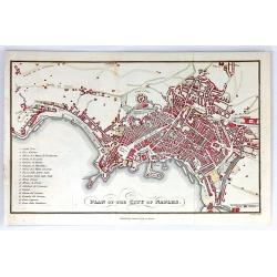
Plan of the City of Naples
A detailed plan of the city of Naples, Italy. The main attractions of Naples are listed in a table to the left. Published by Samuel Leigh in London, about 1820. Engraved ...
Place & Date: London, ca.1820
Selling price: $19
Sold in 2016
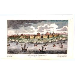
A View of Astracan.
A striking and highly detailed copper engraved panoramic view of Astrakhan,
Place & Date: London, 1820
Selling price: $21
Sold in 2016

Bataille de la Moskowa, livrée le 7 septembre 1812.
Engraved plate of the battle of the Moskowa (or Borodino - 150 km from Moscow), on 7 September 1812. Napoleon is shown to the right, mounted on a white horse standing on ...
Place & Date: Paris, ca.1820
Selling price: $50
Sold in 2017
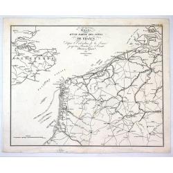
Carte D'Une Partie des Cotes de France.
Minimally detailed map of northern France and southeast Britain by Ambrose Tardieu from:"Precis des Evenements Militaires de plans et de Cartes". It shows Franc...
Place & Date: Paris , 1820
Selling price: $15
Sold in 2017

Uytgegeven Door Fs. de Vletter & Comp. te Amsterdam.
Wonderful, large, stippled, mezzotint engraving by Jan Willem Pienman in Abcoude, the Netherlands, in about 1820. It is an allegory of the death of William V, Prince of O...
Place & Date: Amsterdam, ca. 1820
Selling price: $40
Sold in 2017
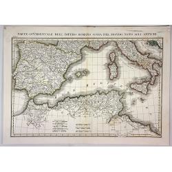
Parte Occidentale Dell Impero Romano Ossia del Mondo Noto Agli Antichi.
A fine map of the Mediterranean Sea with Spain, Italy, Sicily, Sardinia and Northern Africa as they were during the Roman Empire. By L. Rossi in Milan in 1820. Published ...
Place & Date: Milan, 1820
Selling price: $30
Sold in 2018
Asia.
A scarce map of the Asian continent published by Lmarco Bonatti. The map is of interest for the use of East Sea, the sea between Korea and Japan, here called "G. di ...
Place & Date: Roma, 1820
Selling price: $400
Sold in 2017
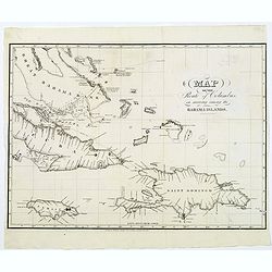
Map of the Route of Columbus, on arriving among the Bahama Islands.
An interesting map of the route Christopher Columbus took when he arrived in the Bahamas. Map extent includes Jamaica, most of Cuba, Saint Domingo, The Caycos Islands, th...
Place & Date: Philadelphia, 1820
Selling price: $75
Sold in 2018
Südliche und nördliche Halbkugel der Erde nach den neuesten Entdeckungen entworfen und berichtiget.
A large world map in two hemispheres, by the Weimar Institute. It is among the last maps to show no Antarctic continent.
Place & Date: Weimar, 1820
Selling price: $150
Sold in 2018