Browse Listings

Le Kaire (Citadelle) Vue Interieure D'Une Mosquee. . .
A fine plate from 'Description de l'Egypte', the important publication by the French government detailing the results of the Napoleon's pioneering military and scientific...
Place & Date: Paris, ca 1820
Selling price: $140
Sold in 2018
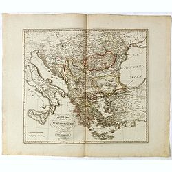
General Charte von der Europaischem Türkey
Nice map of Greece, Albania, etc by Johannes Walch.Johann Walch (1757-1824) was cartographer and map publisher active in Augsburg, he was the son-in-law of Johann Martin ...
Place & Date: Augsburg, 1820
Selling price: $175
Sold in 2019
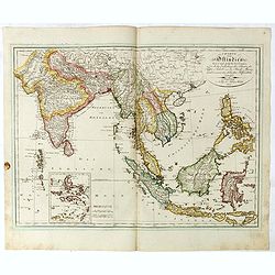
Ostindien.
Nice map of South East Asia published by Johannes Walch. Lower left inset map of the Moluccas and good detail on the Philippines.Johann Walch (1757-1824) was cartographer...
Place & Date: Augsburg, 1820
Selling price: $425
Sold in 2019
![Ch'onha chido [Atlas of all under Heaven]](/uploads/cache/43702-250x250.jpg)
Ch'onha chido [Atlas of all under Heaven]
A nice manuscript example of a Ch’onha chido [Atlas of all under Heaven] with 15 maps, one map more than usually the case. Most have a description of the region or titl...
Place & Date: Korea, ca. 1820
Selling price: $5000
Sold in 2019
Carte générale de L'Europe. . .
Map of Europe prepared by Felix Delamarche, after R.de Vaugondy. In the right hand a lengthy description of geographical details of the different European countries, moun...
Place & Date: Paris, 1820
Selling price: $200
Sold in 2020
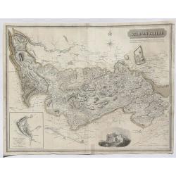
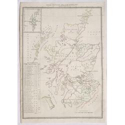
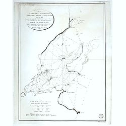
Stirlingshire.
A fine map of Stirlingshire, Scotland by Thomson in 1820. From his Atlas of Scotland published in Edinburgh. It features an inset of the town of Stirling and an engravin...
Place & Date: Edinburgh, 1820
Selling price: $30
Sold in 2023
Index Map to the Atlas of Scotland.
An informative index for Thomson’s “Atlas of Scotland”. Published in 1820 in Edinburgh. It outlines all of the shires in Scotland and states the square miles. It f...
Place & Date: Edinburgh, 1820
Selling price: $22
Sold in 2020
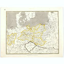
Prussia.
An early nineteenth century map of Prussia, published in Edinburgh. It also shows the southern tip of Sweden, Denmark, and extends as far south as the Carpathian Mountain...
Place & Date: Edinburgh, 1820
Selling price: $20
Sold in 2021
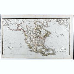
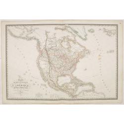
L'America Settentrionale.
Upper part of a two-sheet Italian map depicting North America. A massive Luigiana runs through the center of the United States, overlapping with a large Missouri Territor...
Place & Date: Roma, 1821
Selling price: $200
Sold in 2020
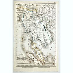
Carte de L'Inde presqu 'ile au de la du Gange. . .
A fine map of a portion of south east Asia which appeared in Tardieu's "Atlas pour Servir a l'Intelligence de l'Histoire Generale des Voyages de Laharpe." Many ...
Place & Date: Paris, ca 1821
Selling price: $55
Sold in 2020
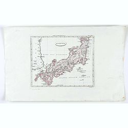
Giappone.
Map of Japan from "Relazione: 'fa parte di:' Nuovo atlante di geografia universale in 52 carte" by Luigo Rossi.
Place & Date: Milan, 1821
Selling price: $50
Sold in 2020
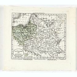
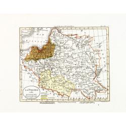
La Polonia colle divisioni del 1772, 1793 e 1795.
Uncommon map of Poland and Lithuania. Appears in: Luigi Rossi's "Nuovo atlante di geografia universale". Engraved by Giuseppe Caniani.With color key. In upper r...
Place & Date: Milan, Presso Batelli e Fanfani, 1820 or 1821
Selling price: $25
Sold in 2020
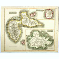
Guadaloupe / Marie Galante / Antigua.
A very finely engraved and detailed map, of both French and English islands in the West Indies. The map is mostly of Guadeloupe, with inset maps of Marie Galante and Anti...
Place & Date: Edinburgh, 1821
Selling price: $60
Sold in 2021
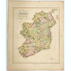
Ancient and Modern Ireland.
A lovely large scale map of the island of Ireland, produced in James Playfair's atlas. The various counties are highlighted in differing colors, with major roads marked, ...
Place & Date: Edinburgh, 1821
Selling price: $150
Sold in 2022

Flower (Plate 83).
Plate from William Curtis (1746-1799) The Botanical Magazine. The publication began in February 1787 and was immediately successful, and the early volumes were quickly so...
Place & Date: London, 1821
Selling price: $20
Sold
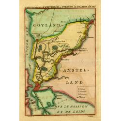
" Carte.. Amsterdam, á Utrecht et Naarden."
Uncommon map showing the road and river Vecht from Amsterdam to Utrecht. Including Naarden, Muiden, Weesp, Loenen, Maarsen, etc.
Place & Date: Amsterdam 1821
Selling price: $100
Sold
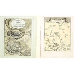
Bern gegen das Ende des dreyzehnten j./ Kriegs-Schauplatz..
Lot of 2 prints showing Bern in ancient times.
Place & Date: Austria 1813/1821
Selling price: $10
Sold in 2008

Flower (Plate 83).
Plate from William Curtis (1746-1799) The Botanical Magazine. The publication began in February 1787 and was immediately successful, and the early volumes were quickly so...
Place & Date: London, 1821
Selling price: $30
Sold
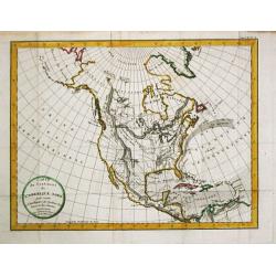
Carte du Continent de l\' Amerique Nord.
A map of North America.
Place & Date: Paris, 1821
Selling price: $250
Sold in 2013
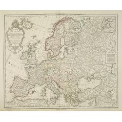
Carte de l'Europe Dressée par G. Delisle et Ph. Buache.. Revue.. Par J. A. Dezauche.
The finely engraved map shows Europe divided up into its countries and the adjacenting regions Russia, the Middle East and North Africa. In the upper left corner we find ...
Place & Date: Paris, 1821
Selling price: $380
Sold in 2011
La Polonia colle divisioni del 1772, 1793 e 1795.
A scarce map of Poland and Lithuania. Appears in: Luigi Rossi's "Nuovo atlante di geografia universale". Engraved by Giuseppe Caniani.With color key. In the upp...
Place & Date: Milan, Presso Batelli e Fanfani, 1820 or 1821
Selling price: $80
Sold in 2015
Carte Physique et Politique de l'Amérique Septentrionale. . .
Huge map of North America and the Caribbean showing the political divisions and colonial possessions with a color key at bottom. Brué prepared the maps for Louis de Onis...
Place & Date: Paris, 1821
Selling price: $500
Sold in 2016

The Foundling.
Hand-colored engraving entitled "THE FOUNDLINGS" engraved by I.Stowe after a painting by William Hogarth. It was published in London by Robert Wilkinson in 1821...
Place & Date: London, Robert Wilkinson, 1821
Selling price: $14
Sold in 2018
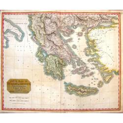
South Part of Turkey in Europe.
A map of Greece, showing Crete, Albania and Turkey. It was drawn & engraved for Thomson's "NEW GENERAL ATLAS" in Edinburgh in 1821.
Place & Date: Edinburgh, 1821
Selling price: $20
Sold in 2016
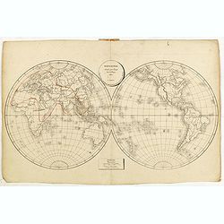
Mappe-Monde, dressée pour l'usage des Colléges 1821 à Paris. . .
Uncommon double hemisphere world map, centered on Australia. Lithography in very delicate hand colors. Small scale in lower part. The continents are empty except for the ...
Place & Date: Paris, 1821
Selling price: $60
Sold in 2017
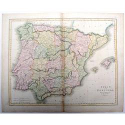
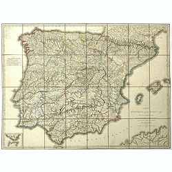
Spain and Portugal drawn & engraved for Dr. Playfair's Atlas.
Fine map of Spain and Portugal from Dr. Playfair's Atlas, from 1821. Published by Macredie, Skelly & Co. in Edinburgh. Engraved by B. Smith.
Place & Date: Edinburgh, 1821
Selling price: $21
Sold in 2018
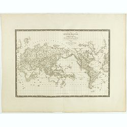
Mappemonde physique sur la projection réduite de Mercator. . .
Uncommon world map in Mercator projection centered on Australia and New Zealand. Prepared by H.Brué and published in his "Atlas Universel".
Place & Date: Paris, 1821
Selling price: $36
Sold in 2015
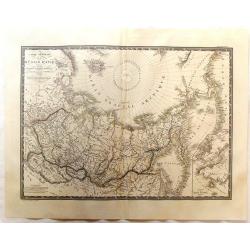
Carte Generale de la Russie d'Asie et des Regions Polaires Borleales.
Fine detailed map of Russia featuring the northern polar regions. The map comes from 'ATLAS UNIVERSEL". Original hand-colored in outline.
Place & Date: Paris, 1821
Selling price: $31
Sold in 2017
Elements of General History Ancient and Modern.
Eight edition of this popular history book written by Alexander Fraser Tytler. At end of volume one, dealing with ancient history 6 folding maps are bound in: Orbis Veter...
Place & Date: London/Edinburgh, 1821
Selling price: $250
Sold in 2016
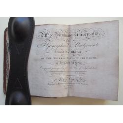
Atlas Minimus Universalis, or A Geographical Abridgement Ancient and Modern of the Several Parts of the Earth. . .
Complete with 58 Hand colored Copper engraved Maps. Near Contemporary Calf. 12mo.A HIGHLY IMPORTANT COPY OWNED BY DANIEL WILSON, BISHOP OF CALCUTTA AND A MANUSCRIPT LOG O...
Place & Date: London, 1821
Selling price: $2500
Sold in 2016
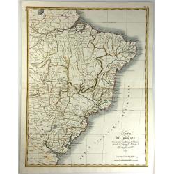
Carte du Bresil, Dressee pouo L'Intelligence de L'histoire Generale des Voyages de Labarpe.
A striking lithograph map of Brazil and the surrounding countries. One of the original maps that show the findings resulting from the voyages of Labarre.
Place & Date: Paris, 1821
Selling price: $100
Sold in 2017
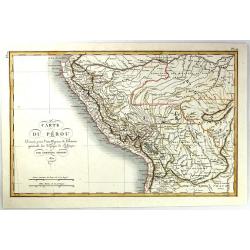
Carte du Perou Dressee pouo L'intelligence de L'histoire generale des Voyages de Labarpe.
A striking lithograph map of Peru and the surrounding countries. One of the original maps that shows the findings resulting from the voyages of Labarpe.
Place & Date: Paris , 1821
Selling price: $30
Sold in 2017
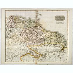
Caraccas and Guiana.
An attractive and detailed map of Venezuela and Guiana, extending Martinique in the north as far south northern Brazil, westwards to Lake Maracaibo across to the Atlantic...
Place & Date: Edinburgh, 1821
Selling price: $80
Sold in 2017
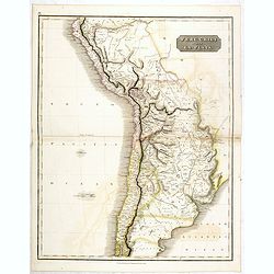
Peru, Chili and La Plata.
This is a beautiful 1817 Thomson map of Peru, Chile and Argentina. It covers Bolivia, Paraguay, Uruguay and parts of Peru, Chile, Argentina and Brazil.The map identifies ...
Place & Date: Edinburgh, 1821
Selling price: $100
Sold in 2016
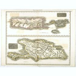
Porto Rico and Virgin Isles / Haiti, Hispaniola...
A map of three interesting West Indian Islands by the Edinburg cartographer John Thomson. Lightly hand colored. Relief shown by hachures.John Thomson was one of the leadi...
Place & Date: Edinburgh, 1821
Selling price: $100
Sold in 2016
Guadaloupe / Marie Galante / Antigua.
A very finely engraved and detailed map, of both French and English islands in the West Indies. The map is mostly of Guadeloupe, with inset maps of Marie Galante and Anti...
Place & Date: Edinburgh, 1821
Selling price: $80
Sold in 2017
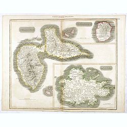
Grenada / Tobago / Curaçao / Trinidad.
A delightfully detailed map of four West Indian islands by John Thomson. The map displays excellent detail concerning each of the islands, including an inset plan of Fort...
Place & Date: Edenburgh, 1821
Selling price: $150
Sold in 2016
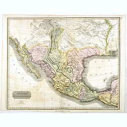
Spanish North America.
The excellent map by the Scottish engraver John Thomson, depicts Mexico from the Yucatan northwards to what would eventually become the Republic of Texas, and the Louisia...
Place & Date: Edinburgh, 1821
Selling price: $500
Sold in 2016
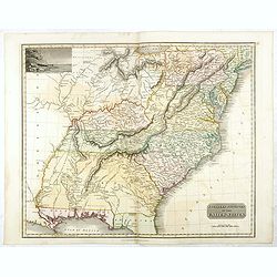
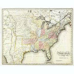
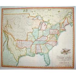
Southern Provinces of the United States.
A very finely engraved and detailed map of United State, that Includes the states and territories east of the Mississippi River to the Atlantic and as far north as Lake E...
Place & Date: Edinburgh, 1821
Selling price: $220
Sold in 2018
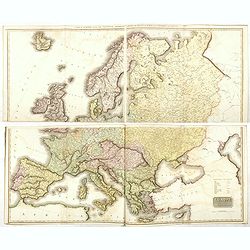
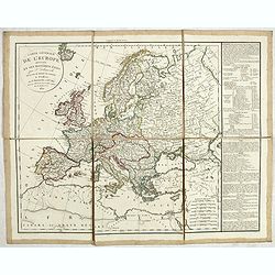
Europe after the Congress of Vienna.
When assembled, this strikingly large 4 sheet map of Europe, measures some 1020 x 1250 mm. The map graphically depicts the political divisions after the Peace of Paris an...
Place & Date: Edinburgh, 1821
Selling price: $220
Sold in 2018
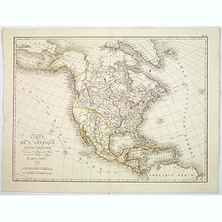
Carte de L'Amerique Septentrionale. . .
An uncommon map of North America, published shortly after the Louisiana Purchase, and the first publication of Lewis & Clark's official report.What makes this map imp...
Place & Date: Paris, 1821
Selling price: $130
Sold in 2017
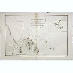
![Plan du Port de Ste. Helene a la cote des Patagons levee en 1794. . . [together with] Plan des Port de Melo dans la Partie N. du Golfe de St. George...](/uploads/cache/39153-250x250.jpg)
Plan du Port de Ste. Helene a la cote des Patagons levee en 1794. . . [together with] Plan des Port de Melo dans la Partie N. du Golfe de St. George...
Two engraved charts. Relief shown hachures, soundings in brasses françaises. Includes "Vue de l'Entree du Port de Ste. Helene ..." Scales of maps (ca. 1:23,500...
Place & Date: Paris, after 1821
Selling price: $50
Sold in 2018
Plan du de la rade et du Barachois des Isles St. Pierre et Miquelon Levé en 1818.
Engraved of Saint Pierre and Miquelon, a self-governing territorial overseas collectivity of France, situated in the north-western Atlantic Ocean near the Newfoundland a...
Place & Date: Paris, 1821
Selling price: $50
Sold in 2018
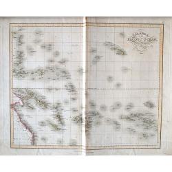
Islands in the Pacific Ocean, drawn & engraved for Dr. Playfairs Atlas.
A detailed steel engraved map of the South Pacific, from Australia to Hawaii, including the Marquesas and the Society Islands (French Polynesia). Many even smaller island...
Place & Date: London, 1821
Selling price: $20
Sold in 2018
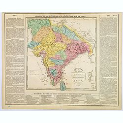
Hindoostan or India.
A fascinating 'Geographical, Historical and Statistical Map of India'. The map indicates 'British Possessions or Dependencies', and identifies 'A Place remarkable for a B...
Place & Date: Philadelphia, 1821
Selling price: $45
Sold in 2019
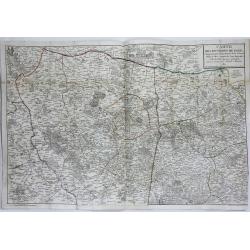
Carte des Environs de Paris.
A large, very detailed map of Paris and her surrounding area by Pichon (Ingeniur Geographe) and corrected by Amedee Martin. It was published by Chez Esnault in Paris in 1...
Place & Date: Paris, 1821
Selling price: $40
Sold in 2019
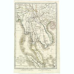
Carte de L'Inde presqu 'ile au de la du Gange. . .
A fine map of south east Asia which appeared in Tardieu's "Atlas pour Servir a l'Intelligence de l'Histoire Generale des Voyages de Laharpe." Many regions and c...
Place & Date: Paris, ca 1821
Selling price: $75
Sold in 2019
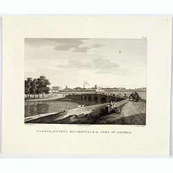
Madras, Entrée Occidentale du Fort St. George.
An attractive copperplate engraving of the east entrance to the St. George Fort in Madras (Chennai) in southern India. You can see an impressive wall surrounding the fort...
Place & Date: Anon, ca 1821
Selling price: $21
Sold in 2020
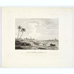
Vue du Fort St. George a Madras prise a l'est.
A nice copperplate view of Madras from the south east, engraved after the Daniell aquatint from his book Oriental Scenery, or Views of the Architecture, Antiquities and L...
Place & Date: Paris ca 1821
Selling price: $40
Sold in 2019
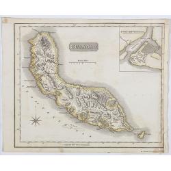
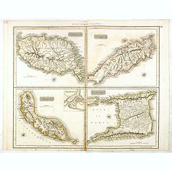
Curaçao.
A delightfully detailed map the West Indian island Curaçao by John Thomson. The map displays excellent detail concerning, including an inset plan of Fort Amsterdam in Cu...
Place & Date: Edenburgh, 1821
Selling price: $150
Sold in 2019
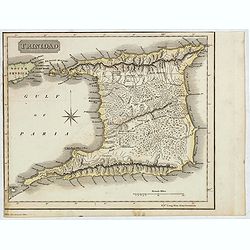
Trinidad
A delightfully detailed map the West Indian island Trinidad by John Thomson. The map displays excellent detail concerning roads, rivers, towns, bays, harbors and other in...
Place & Date: Edenburgh, 1821
Selling price: $50
Sold in 2021
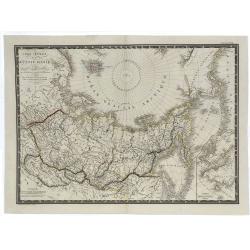
Carte Générale de la Russie d'Asie et des Regions Polaires Boreales.
A fine large-format 1821 Brué map of Russia and the Arctic Ocean featuring the North Pole at the upper centre of the map. Though not a true polar projection, it suggest...
Place & Date: Paris, 1821
Selling price: $17
Sold in 2019
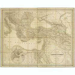
Carte de l'Empire Ottoman en Europe, en Asie et en Afrique, avec les pays limitrophes.
Large map on the Ottoman Empire, engraved and published by J. Alexis Orgiazzi, engraver for the Dépôt Général de la Guerre. It stretches from north to south between H...
Place & Date: J.A. Orgiazzi, Paris, 1822
Selling price: $240
Sold in 2012
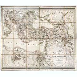
Carte de L'Empire Ottoman en Europe, en Asie et en Afrique, avec les pays limitrophes. . .
Large folding map of the Ottoman Empire, engraved and published by J. Alexis Orgiazzi. The map stretches from north to south between Hungary and Egypt and from west to ea...
Place & Date: Paris, 1822
Selling price: $325
Sold in 2013
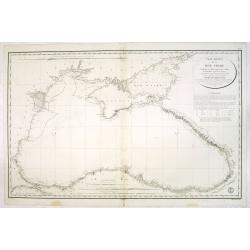
Carte réduite de la Mer Noire... Par M.Gauttier Captaine de Vaisseau secondé par M. Benoist...
Large scale chartof the Black Sea prepared by M. Gautier. Engraved by E.Collin. Stamp of the ‘ Depot General de la Marine’ at lower right corner.The chart shows sound...
Place & Date: Paris, 1822
Selling price: $300
Sold in 2013

The Sleeping Congregation.
Inscription: in plate below image, lower left: 'Invented Engraved & Published October 25: 1736 by W-m Hogarth Pursuant to an Act of Parliament / One shilling"; i...
Place & Date: London, 1822
Selling price: $120
Sold in 2018

Sigismonda.
Large copper engraving of William Hogarth's "Sigismonda". It is from the Heath Edition from 1822. This print shows a woman leaning on a table. The model for th...
Place & Date: London, 1822
Selling price: $20
Sold in 2018

Before - A Girl's Last Minute Resistance.
Fine large, hand colored copperplate engraving featuring a woman resisting a man's advances. By William Hogarth, published in London in 1736, but a re-strike of the orig...
Place & Date: London, (Heath edition), 1822
Selling price: $20
Sold in 2016
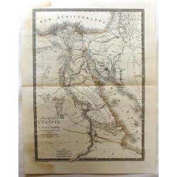
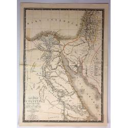
Carte Generale de L'Egypte et de L'Arabie Petree.
Fine, detailed map of Egypt and Saudi Arabia. From Atlas Universel. By Adrian Brue, the royal cartographer.
Place & Date: Paris, 1822
Selling price: $20
Sold in 2017
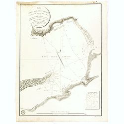
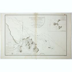
Plan de la Baie Saint George Situe a la CoteOccidental de Terre-Neuve, Leve en 1820. . .
Fine of the interior of St. George's Bay near the present-day towns of Stephenville and Saint George's on the Southwest coast of Newfoundland. Relief shown by hachures. ...
Place & Date: Paris, 1822
Selling price: $120
Sold in 2016
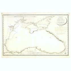
Carte réduite de la Mer Noire... Par M.Gauttier Captaine de Vaisseau secondé par M. Benoist...
Large scale chartof the Black Sea prepared by M. Gautier. Engraved by E.Collin. Stamp of the ‘ Depot General de la Marine’ at lower right corner.The chart shows sound...
Place & Date: Paris, 1822
Selling price: $400
Sold in 2017
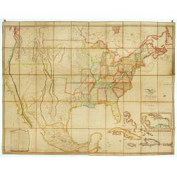
United States of America.
An uncommon and important map by the well recognized American cartographer John Melish. Shows both the newly formed state of Missouri and the massive Missouri Territory.M...
Place & Date: Philadelphia, H.C. Carey & I. Lea, 1822
Selling price: $1100
Sold in 2019
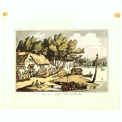
View near Newport Isle of Wight
View near Newport on the Isle of Wight, from an extremely rare series of eighteen aquatint plates, "Rowlandson's Sketches From Nature, depicting views of the West of...
Place & Date: London, 1822
Selling price: $75
Sold in 2016
![[ Boney & Talley. The Corsican carcase-butcher's reckoning day]](/uploads/cache/37273-250x250.jpg)
[ Boney & Talley. The Corsican carcase-butcher's reckoning day]
Aquatint by James Gillray and published by Hannah Humphrey. Showing the interior of a carcass-butcher's slaughter-house, the carcasses of animals suspended from the wall....
Place & Date: London, 1822
Selling price: $100
Sold in 2016
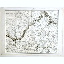
Carte de la Moravie déssinée et gravée par Ambroise Tardieu.
Very detailed map including Vienna and the Czech Republic with Prague Olmutz.
Place & Date: Paris, 1822
Selling price: $14
Sold in 2023
Plan de l'Embouchure de la Rivière de Cayenne et des Mouillages extérieures. . .
Early chart of coast offshore to Cayenne.
Place & Date: Paris, ca.1822
Selling price: $45
Sold in 2018
Carte generale L'Egypte Ancienne de la Palestine et de L'Arabie Petree.
A pleasing map featuring Ancient Egypt including Palestine and Arabia. It is by Brue from his "Atlas Universel", and was engraved by L'Auteur.
Place & Date: Paris, 1822
Selling price: $10
Sold in 2017
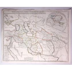
Partie Orientale de la Carte des Anciennes Monarchies...
A striking map depicting the eastern part of the ancient world including the Near East, Cyprus, Black Sea Iran & Iraq by Gilles de Vaugondy, and later improved and re...
Place & Date: Paris, 1822
Selling price: $20
Sold in 2017
Carte d' Espagne et de Portugal en neuf feuilles. . .
Folding map of Spain and Portugal for the usage of travelers. Published by Edme Mentelle (1730-1815), geographer and historian at the Institut des Sciences, and Jean Bapt...
Place & Date: Paris, 1822
Selling price: $250
Sold in 2023
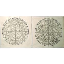
Celestial Map of the Constellations in the Northern & Southern Hemispheres (2 Maps).
A finely engraved pair of celestial charts after Alexander Jamieson. Jamieson based much of this work from that of Johann Elert Bode (1747–1826), who was director of th...
Place & Date: London, 1822
Selling price: $160
Sold in 2020
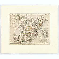
United States.
A small map of the east and south east of the United States. From Louisiana , up to the 'Northwest Territory' and across to New England and down to Florida. There is an i...
Place & Date: London, 1822
Selling price: $29
Sold in 2019
Plan de l'Embouchure de la Rivière de Cayenne et des Mouillages extérieures. . .
Early chart of coast offshore to Cayenne. Prepared by C.L. Grassier and engraved by Ambroise Tardieu and P.J. Besançon. Detailed chart published by Dépôt Générale de...
Place & Date: Paris, ca.1822
Selling price: $55
Sold in 2020
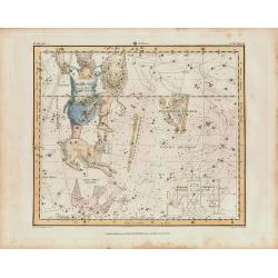
Jamieson Celestial chart plate 24, first edition.
Plate 24 Eridanus, Orion, Lepus, Columba, Cela Sculptoris, Psalterium Georgii, Sceptrum Brandenburgium.From Alexander Jamieson’s Celestial Atlas which appeared in Febru...
Place & Date: London, 1822
Selling price: $100
Sold in 2019
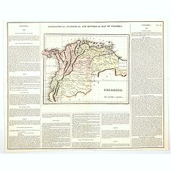
Geographical, Statistical, and Historical Map of Colombia.
One of the first separate maps of the newly independent Colombia and Venezuela, which was still steeped in Revolution under the irrepressible work of Simon Bolivar. The m...
Place & Date: Philadelphia, 1822
Selling price: $80
Sold in 2020
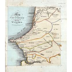
Map of the Countries Inhabited by the Wolofs
Rare map of Senegal and Gambia. The map is shows good detail of villages, regionas, and topographical features. Published in Ackermann's The World in Miniature. Africa.....
Place & Date: London, 1822
Selling price: $150
Sold in 2022
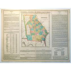
Geographical, Statistical and Historical Map of Georgia
Nice example of this fine map of Georgia, from the 1827 edition of Carey & Lea's Geographical, Statistical and Historical Atlas of America, with two columns of conte...
Place & Date: Philadelphia, 1822
Selling price: $220
Sold in 2023
United States of America Compiled from the latest and best..
An uncommon and important map by the well recognized American cartographer John Melish, engraved by Samuel Harrison. Melish was the first American publisher to issue excl...
Place & Date: Philadelphia, 1822
Selling price: $1300
Sold

Chapeau de velours plein.. (2047)
From Costume Parisien (1797-1839).Paris was the capital for fashion innovation and design. After the final defeat of Napoleon, English and French fashions merged to close...
Place & Date: Paris 1822
Selling price: $10
Sold
Map of the United States with contiguous British & Spanish Possessions.
.. compiled from the latest & best authorities by John Melish. Engraved by J. Vallance and [H.S.] Tanner. Entered according to Act of Congress the 16.th day of June 1...
Place & Date: Philadelphia, 1822
Selling price: $30025
Sold
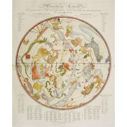
Planisferio Celeste..
Decorative large-scale hemisphere celestial chart, with a diameter 603mm., calculated for the year 1800. With descriptive key to zodiac signs in German, French and Italia...
Place & Date: Milan, c.1822
Selling price: $900
Sold in 2009