Browse Listings
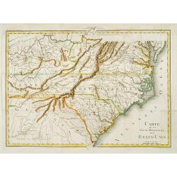
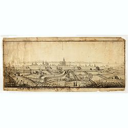
Carte de la partie méridionale des Etats-Unis.
Detailed map of North and South Carolina, Kentucky, Tennessee and Virginia. A separate publication of Pierre François Tardieu.With in lower left corner the address: Grav...
Place & Date: Paris 1800
Selling price: $550
Sold
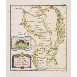
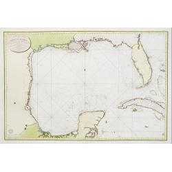
Carte du Cap de Bonne Esperance et de ses Environs.
A very nice map of the tip of South Africa, showing Cape of Good Hope, including an inset view of Cape Town and the Tafel Berg. Title cartouche on the lower left-hand cor...
Place & Date: France c.1800
Selling price: $190
Sold
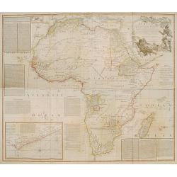
Africa with all its States, Kingdoms, Republics, regions..
A large wall map of Africa. Impressive title cartouche upper right corner.Based on a map by D'Anville.Top left inset map of the Azoren Islands.
Place & Date: London 1800
Selling price: $700
Sold
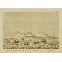
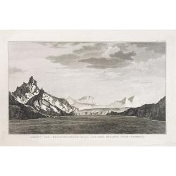
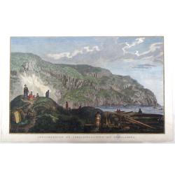
Vue des montagnes du Cap de Bonne-Espérance. . .
View of the Cape of Good Hope showing sailing ships foreground.
Place & Date: Paris, 1800
Selling price: $50
Sold
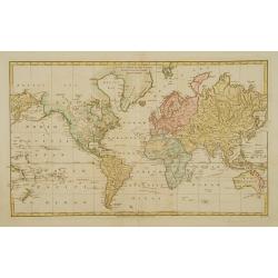
A new Mercator's chart drawn from the latest discoveries.
Map of the world in Mercator' projection., showing the tracks of captain Cook (1776-1779). Engraved by W.Harrison.
Place & Date: London 1800
Selling price: $100
Sold
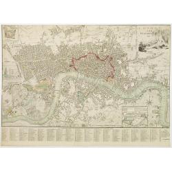
London and Westminster.
Title with engraving of Father Thames top right. At the bottom right, a compass rose and at the bottom center, a scale bar. Map divided into rectangles and lettered for r...
Place & Date: London, 1800
Selling price: $750
Sold in 2016
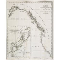
Karte von einem theil der Nord westlichen Küste von America..
A very nice map centered on Northwest coast of America, including the city of Vancouver. On the lower left corner, an inset map (285x208 cm) of Japan, Taiwan and Chinese ...
Place & Date: Berlin 1800
Selling price: $350
Sold
Reis-kaart van het Britsche gezantschap van Hang-choe-foe naar Quang-choe-foe of Kanton in China.
Uncommon map of eastern part of China, showing a journey of the English Embassy from Hangzhou (south of Shanghai) to Guangzhou (Canton). The maps is giving a wealth of in...
Place & Date: Netherlands c.1800
Selling price: $80
Sold
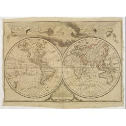
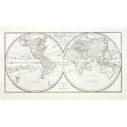
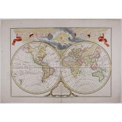
Mappemonde a l'usage de l'instr.on par premiers géographes et de l'académie des sciences..
An updated version of the double hemisphere world map by Buache of 1785. As the map was printed after the French Revolution, and the original dedication to the King was r...
Place & Date: Paris 1800
Selling price: $500
Sold
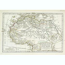
Barbarie, Egypte, Nigritie, Guinée, Nubie..
Detailed map depicting Africa from the Maghreb to actual Cameroon. Showing the Canaries, Cap-Verde. Depicting also a part of south Spain, Sicily, South Italy, South Greec...
Place & Date: Paris, 1800
Selling price: $80
Sold in 2010
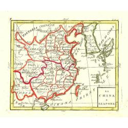
La China e Giapone.
Uncommon map of China, Korea, Japan and Taiwan (I.Formosa), only one town labelled, Tayoan. Very strange shape for Japan.
Place & Date: Italy c. 1800
Selling price: $150
Sold
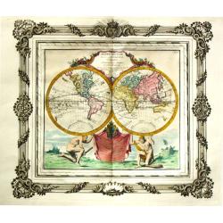
Mappe-Monde.
A world map in two hemispheres based upon the astronomical observations of Tschirikow and Guillaume de l'Isle of 1741. The Russian captain Tschirikow surveyed the northwe...
Place & Date: Paris, c.1800
Selling price: $550
Sold
Carte des cotes du Golfe du Mexique..
Detailed and important early chart of the Gulf Coast and Florida and dated 1800. From Neptune des cotes occidentales d'Amerique sur le Grand Ocean, an extensive atlas of ...
Place & Date: Paris 1800
Selling price: $1750
Sold
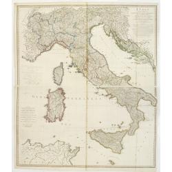
Italy with the Addition of the Southern Parts of Germany as far as.. the Illyric Islands..
Comprehensive map of Italy printed on 4 sheets, joined 2 by 2. Good detail is given with settlements, common and post roads, etc. Relief shown pictorially.
Place & Date: London, 1800
Selling price: $900
Sold in 2008
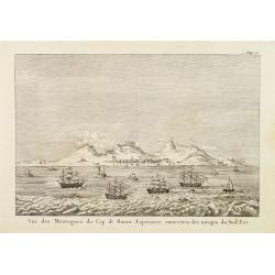
Vue des montagnes du Cap de Bonne-Espérance. . .
View of the Cape of Good Hope showing sailing ships foreground.
Place & Date: Paris, 1800
Selling price: $65
Sold

Allgemeiner Grosser Atlas, 1800.
Franz Anton Schraemble (1751-1803), Austrian cartographer. Allgemeiner deutscher Atlas aller Länder, 1786-94, Allgemeiner Grosser Atlas, 1800.
Place & Date: Wien, 1800
Selling price: $275
Sold
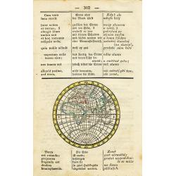
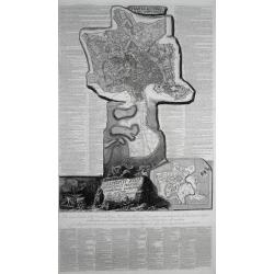
untitled (Eastern Hemisphere)
Interesting and rare map printed within a page from a dictionary. Published probably around 1800 it translates astronomical terms into three languages. The map shows the ...
Place & Date: ca. 1800
Selling price: $35
Sold in 2010
![Vue du sperbe Temple de St.Sophie [. . .] a Constantinople.](/uploads/cache/02982-250x250.jpg)
Vue du sperbe Temple de St.Sophie [. . .] a Constantinople.
A fanciful depiction of the Aya Sofya in Istanbul. In the eighteenth and nineteenth centuries there were many popular speciality establishments in Paris, Augsburg and Lon...
Place & Date: Paris, 1800
Selling price: $220
Sold in 2014
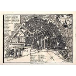
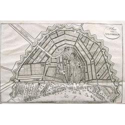
A plan of the City of Amsterdam
Very detailed plan of Amsterdam with a letter key (1-51) identifying important buildings, markets, and places. With a decorative title cartouche featuring a harbor scene....
Place & Date: London, 1800
Selling price: $110
Sold in 2008
![[ A manuscript map of the Arabian Peninsula. ]](/uploads/cache/30264-250x250.jpg)
[ A manuscript map of the Arabian Peninsula. ]
Detailed manuscript map of the Arabian Peninsula, including Bahrain, Oman, etc. To the left the River Nile.The map follows closely the outline by D'Anville, but with an i...
Place & Date: Germany, c. 1800
Selling price: $1500
Sold
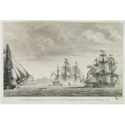
Combat de la Frégate française La bellone contre le v.au Anglais Le Foudroyant le 21. Vendémaire An 7. (1798)
Beautiful aquatint of the French frigate "La Bellone" shown during a sea battle against the British "Le Foudroyant" in 1798, after L.Léon.
Place & Date: Paris, c.1800
Selling price: $120
Sold in 2012
Philadelphia in Amerika. / Bonaparte an der spitze seiner Pariser National Garde am 8 Novemb. 1799
Copper engraving with four scenes on one sheet. In upper part a view of Philadelphia. Published in "Allgemeine Welt-Chronik oder neue und wichtige Zeit-Geschichte al...
Place & Date: Zittau, 1798-1800
Selling price: $1200
Sold
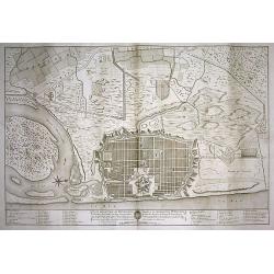
PLAN DE LA VILLE DE PONDICHERI DEDIÉ A LA MÉMOIRE DE Mr. DUPLEIX...
Very large and unusual plan of the city of Pondichéry in India. The map depicts the famous hold-off of the British Navy by Dupleix during the siege in 1748. Large scale...
Place & Date: Paris, ca.1800
Selling price: $250
Sold in 2009
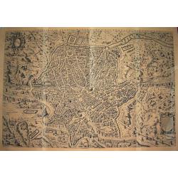
Urbis Romae sciographia ex antiquis monumentis accuratiss delineata.
Large scale & influential wall-map showing the city plan of Ancient Rome. The plate in 8 sheets was first engraved and published by Stephanus Du Perac in 1574, and th...
Place & Date: Rome, ca. 1800
Selling price: $1500
Sold in 2010
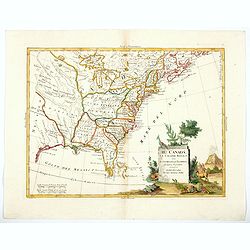
Il Canada le Colonie Inglesi con Luigiana e Florida . . .
Map of East coast of America including the Great Lakes. Fine title cartouche lower right hand corner. From Zatta's Atlante Novissimo.
Place & Date: Venise, 1800
Selling price: $240
Sold in 2010
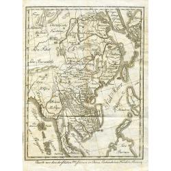
Charte von den christlichen Missionen in China, Cochinchina, Tunkin, Siam, etc.
Unusual German map of South-East Asia showing Korea, Japan, China, Taiwan, the Philippines, Borneo, Malaysia, Thailand, Vietnam, Laos, Cambodia, and Myanmar. Most of them...
Place & Date: probably Germany around 1800
Selling price: $140
Sold in 2009
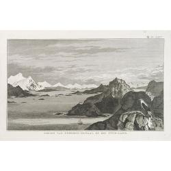
GEZIGT VAN KERSMIS-KANAAL OP HET VUUR-LAND . Pl. LXX*.
A landscape and sea coast view of mountains and a ship in the Strait of Magellan. From a Dutch edition of James Cook.
Place & Date: Amsterdam, ca. 1800
Selling price: $45
Sold in 2010
GEZIGT VAN BEZITNEEMING-BAAI AAN HET EILAND ZUID-GEORGIE. Pl.LXXI*.
A landscape and sea coast view of the South Georgian mountains.South Georgia is a British overseas territory in the southern Atlantic Ocean. This territory is a remote an...
Place & Date: Amsterdam, ca. 1800
Selling price: $25
Sold in 2016
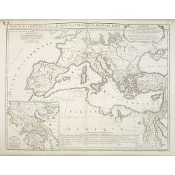
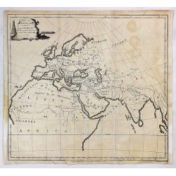
Partie Occidentale de la Carte des Anciennes Monarchies. . .
This map depicts the western part of the Ancient World, Partie Occidentale de la Carte des Anciennes Monarchies including southern Europe and northern Africa. An inset ma...
Place & Date: Paris, ca. 1800
Selling price: $150
Sold in 2010
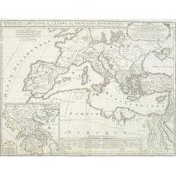
Partie Occidentale de la Carte des Anciennes Monarchies. . .
This map depicts the western part of the Ancient World, Partie Occidentale de la Carte des Anciennes Monarchies including southern Europe and northern Africa. An inset ma...
Place & Date: Paris, ca. 1800
Selling price: $180
Sold
Imperii Occidentis Tabula synoptica.
Map of the Western part of the Empire of Julius Caesar. The map includes Western Europe, up to the east coast of Greece. With the western part of the Mediterranean with t...
Place & Date: Paris, c.1800
Selling price: $50
Sold in 2013
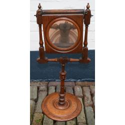
Zograscope (The optical diagonal machine)
The optical diagonal machine is a viewing apparatus to view optical prints whose main components are a large, double convex lens and a mirror fixed directly behind it at ...
Place & Date: France, ca. 1800
Selling price: $950
Sold in 2011

Constantinopolis.
Copper engraving with in top a panoramic view of Constantinople with a numbered key (1-27) and in lower part a the diplomatic convoy of Graf Damian Hugo von Virmondt ente...
Place & Date: Zittau, 1798-1800
Selling price: $1200
Sold in 2011
Mappemonde des deux hémispheres. . .
Map of the world in double hemisphere showing the track of Robinson Crusoé.
Place & Date: Paris, 1800
Selling price: $70
Sold in 2011
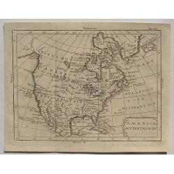
America Settentrionale.
An interesting rare copper engraved map of North America by an unknown cartographer in about 1800. Text in Italian. The cartouche is quite plain but it does have minimal ...
Place & Date: Spain, ca 1800
Selling price: $95
Sold in 2020
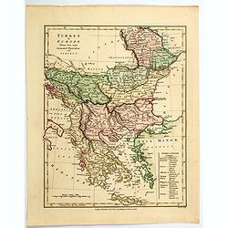
Turkey in Europe.
An attractive map, in beautiful original color, of Turkey in Europe, that part of the Ottoman Empire that lay west of Constantinople. It shows the countries that border t...
Place & Date: London, 1800
Selling price: $17
Sold in 2020
![[No Title] A pair of celestial gores.](/uploads/cache/45931-250x250.jpg)
[No Title] A pair of celestial gores.
Two hand colored engraved gores: one showing the northern hemisphere (sheet nine with Hercules), and the southern hemisphere (sheet nine with Serpent and Scorpion. These ...
Place & Date: Paris, 1693 but ca. 1800
Selling price: $550
Sold in 2020
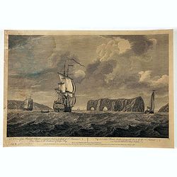
A view of the of the Pierced Island, a remarkable rock in the Gulf of St. Laurence - two leagues to the southward of Gaspée Bay. . .
Print shows a warship in the foreground approaching rock formation in the Gulf of Saint Lawrence. Drawn on the spot by Capt. Hery. Smyth and engraved by Pierre Charles Ca...
Place & Date: London, ca. 1800
Selling price: $155
Sold in 2020
Il Canada le Colonie Inglesi con Luigiana e Florida. . .
A splendid map of the east coast of America including the Great Lakes. With a decorative and fine title cartouche lower right hand corner, and mileage scales. From Zatta'...
Place & Date: Venice, 1800
Selling price: $350
Sold in 2020
![[Untitled French Satircal Cartoon]](/uploads/cache/46793-250x250.jpg)
[Untitled French Satircal Cartoon]
A delightful French satirical cartoon, a 'John Bull' allegory. Set in the 'Orange Café' in Plymouth it features John Bull seated on the left, Major Grosswener seated in ...
Place & Date: Paris, ca 1800
Selling price: $50
Sold in 2020
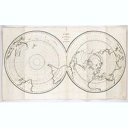
Carte des deux Regions Polaires. . .
This scarce and unusual twin hemisphere map is presented on a polar projection. The approximate position of the northern magnetic pole, indicated by a large shaded area, ...
Place & Date: Paris, ca 1800
Selling price: $200
Sold in 2021
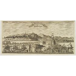
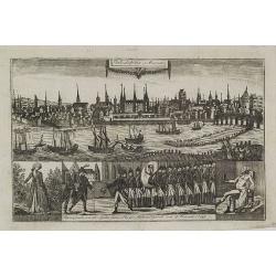
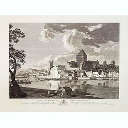
Die Stadt Carthagena in West Indien.
Panoramic view of the town of Cartagena in present-day Colombia, with a variety of boats and ships who dominate the foreground with the town and its surroundings depicted...
Place & Date: Zittau, 1798 - 1800
Selling price: $525
Sold in 2013
Auss Schiff und Anländung der Spanischen Völcker bey Ceuta in Africa. . .
Very rare and decorative but fanciful copper engraved view of the Siege of Ceuta by the Moroccan Sultan in 1418. The Sultan was defeated and the town stayed in Spanish / ...
Place & Date: Zittau, 1798-1800
Selling price: $500
Sold in 2020
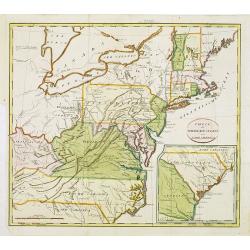
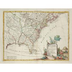
Theil der Vereinigten Staten von Nord America.
Detailed map of eastern part of the United States. In lower right hand corner inset map of Georgia, North and South Carolina.Showing routes of Mr. Weld.
Place & Date: Germany, c.1800
Selling price: $900
Sold in 2012
Het Valkhof of Vorstendoms-Burgt, eeven voor de slooping in 1795 getteekend.
Engraved by Ernst Karl Gottlieb Thelott after a model of Hendrik Hoogers. Beautiful view of "Het Valkhof at Nijmegen.
Place & Date: Netherlands, ca. 1800
Selling price: $200
Sold in 2012
Het Valkhof te Nymegen, nevens het geruïneerde door de watervloed in 17874, ten ooste te zien.
Engraved by Ernst Karl Gottlieb Thelott after a model of Hendrik Hoogers. Beautiful view of "Het Valkhof at Nijmegen.
Place & Date: Netherlands, ca. 1800
Selling price: $200
Sold in 2012
![[ Map of eastern Belarus, including Smolensk ] BL. 6.](/uploads/cache/30621-250x250.jpg)
[ Map of eastern Belarus, including Smolensk ] BL. 6.
Map of eastern part of Belarus. Map show the cities of Viciebsk, Orsha, Barysau, etc. including Smolensk in Russia. More about folding maps. [+]
Place & Date: France, ca. 1800
Selling price: $105
Sold in 2013
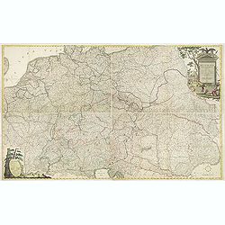
Deutschlands Postkarte begraenzt von Oesterreich, Preussen, Frankreich, Holland, Italien und der Schweiz. . .
Detailed and important post road mapspost route map prepared by Ignaz Heymann.
Place & Date: Triest, 1800
Selling price: $750
Sold in 2013
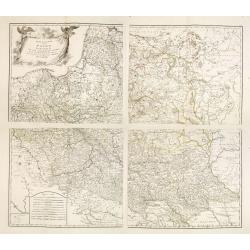
Generalkarte von Polen, Litauen, und den angraenzenden Laendern. . . (4 sheet map)
Large four sheet map of Poland, Lithuania, Vojvodina. Pages 85, 86, 87 and 88 from "Allgemeiner Grosser Schrämblischer Atlas" published by P. J. Schalbacher - ...
Place & Date: Vienna, 1788-1800
Selling price: $800
Sold in 2013

Hypericum Hircinum, Millepertuis Setide.
Very fine botanical stipple engraving by Pancrace Bessa, one of the most famous botanical artists of all time. From his "Trait des Arbres et Arbustes que l'On Cultiv...
Place & Date: Paris, c1800
Selling price: $40
Sold in 2019
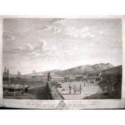
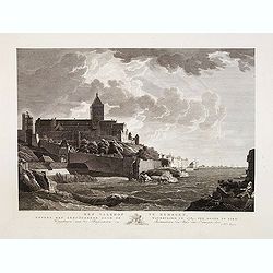
Veduta del Porto di Reggio Calabria.
View of the Italian port of Reggio Calabria engraved by Giovanni de Grado. Engraved from the painting by Hackert in the Reggia di Caserta, it belongs to the collection de...
Place & Date: Naples, circa 1800
Selling price: $650
Sold in 2014
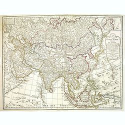
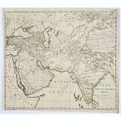
Carte de Asie dresse´e pour l'instruction . . . par Guil. Delisle et Phil. Buache ... nouvellement revue et augmentee´ par Dezauche.
Map of Asia. Relief shown pictorially. Small inset map on the upper right corner. Published by Dezauche. Dated 1800.Notable for depiction of Hokkaido, here called "I...
Place & Date: Paris, 1800
Selling price: $400
Sold in 2013

Neflier cultivé. Mespilus germanica L.
Common medlar, engraving by P.F. Le Grand after designs by the Dutch born Gerard van Spaendonck (1746-1822).Taken from the rare work "Fleurs dessinées d'après natu...
Place & Date: Paris, c.1800
Selling price: $750
Sold in 2017
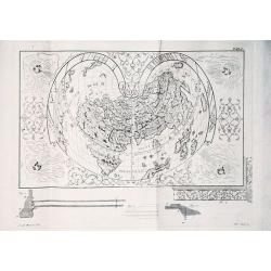
Illustrazione di un'urnetta lavatora d' oro... col inscrizione Paulus Ageminius faciebat.
Description of a gold urn with a cordiform world map (21 x 28 cm) engraved by Paolo Rizzo in c. 1560. Since the urn is no longer extinct, the engraved plate is the only s...
Place & Date: Venice, 1800
Selling price: $350
Sold in 2016
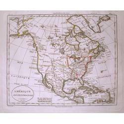
Amerique Septentrionale.
Interesting map of North America, where the Mississippi River serves as the western boundary of the United States, with the western frontier under Spanish rule. Several s...
Place & Date: Paris, c1800
Selling price: $130
Sold in 2014
Captain Cook's Inboorlingen en Verblijfplaatsen Van Oonalashka.
A view from the Dutch edition of Cook's voyages featuring native Americans in the village of Oonalashka.
Place & Date: Amsterdam, 1800
Selling price: $41
Sold in 2016
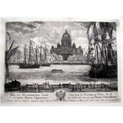
Vue sur la Catedrale Saint Isaak du coté du Palais de Prince Menchikoff.
A rare etching of the Cathedral (Saint Isaac's Cathedral or Isaakievskiy Sobor, Russian: Исаа́ки&...
Place & Date: Saint Petersburg, after 1800
Selling price: $210
Sold in 2016
Vue de la Ville de citadelle capitale. Elle est dessinée du costé de terre ou costé de la porte pour aller à mahon.
Interesting and detailed water color of a panoramic view of the town of Mahon, seen from the land side.
Place & Date: Mahon, ca. 1800
Selling price: $1850
Sold in 2015
Pianta Di Roma E Del Campo Marzo.
Large sheet printed from 3 plates showing a city plan of modern (18th century) Rome within the Aurelian Walls, together with an extension showing the area between Porto d...
Place & Date: Rome, ca. 1800
Selling price: $1950
Sold in 2016
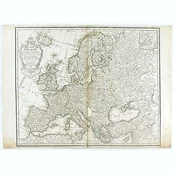
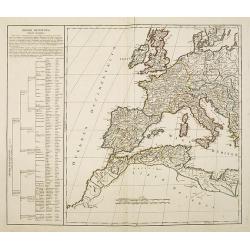
Carte de l'Europe Dressée pour l'Instruction . . .
The finely engraved map shows Europe divided up into its countries and the adjacenting regions Russia, the Middle East and North Africa. In the upper left corner we find ...
Place & Date: Paris, 1800
Selling price: $150
Sold in 2020
Atlas pour servir à la relation du voyage à la recherche de la Pérouse,...
A rare complete first edition in folio with title-page, a large folding map by Barbié du Bocage, and 43 engraved plates by Copia, Perée, and Maleuvre after drawings by ...
Place & Date: Paris, 1800
Selling price: $1050
Sold in 2016
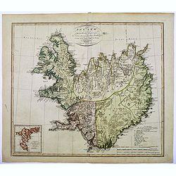
Island nach Murdochischer Projection...
An unusual map of Iceland by the German cartographer and geographer J.C.M. Reinecke, based on an earlier survey map by the Frenchman Verdun de la Crenne, done a generatio...
Place & Date: Weimar, 1800
Selling price: $315
Sold in 2016
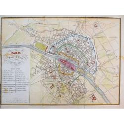
Paris sous le regne de Louis XIII.
Unusual plan which shows Paris as it was in the beginning of the 17th century. A very detailed map, with street names, parks, places, hospitals, and important buildings s...
Place & Date: after 1800
Selling price: $50
Sold in 2016

Denkmal - Peter I Kaiser von Russland. In Petersburg.
Copper engraving of Peter the Great statue in Saint Petersburg. The Bronze Horseman is an equestrian statue of Peter the Great in Saint Petersburg, Russia. Commissioned b...
Place & Date: Germany, ca. 1800
Selling price: $10
Sold in 2016
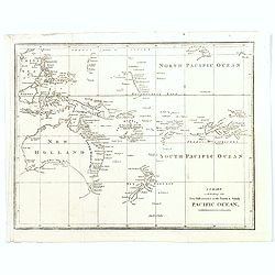
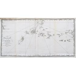
A Chart exhibiting the New Discoveries in the North & south Pacific Ocean.
A scarce folding chart, probably from an English travel journal, produced in the late eighteenth century, showing the latest cartographic discoveries within the Pacific r...
Place & Date: London, ca. 1800
Selling price: $350
Sold in 2016
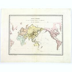
Mappa-Mondo per indicare la principale costruzione, e la configurazione de Due Continenti.
This is a highly unusual Italian map of the world, shown on Mercator's projection, focusing on the physical, or topographical features of the continents, without any poli...
Place & Date: Rome, 1800
Selling price: $80
Sold in 2016
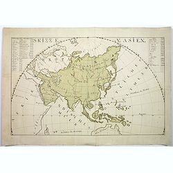
Skizze v. Asien.
A large manuscript map of Asia, includes top of Australia eastern Africa and parts of Europe. With German text. Signed "Katusch", only one other manuscript map,...
Place & Date: ca 1800
Selling price: $675
Sold in 2017
Nouvelle description des Iles Carolines. au R. P. Daubenton.
A very unusual map of the Caroline Islands with Palau. Includes a small part of Guiuan in the Philippines. Includes the tracks of Dr. Bern in 1712.
Place & Date: Unknown, ca. 1800
Selling price: $80
Sold in 2017
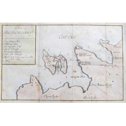
Der Baltische Hafen.
A curious map of the Pakri Islands in Estonia. With Suur-Pakri and Väike-Pakri and the near coast of Paldiski.A legend (a-h) names a sunken ship among other things! Furt...
Place & Date: Unknown, ca. 1800
Selling price: $100
Sold in 2017

Revolution of France.
Fine Mezzotint featuring the genius of Literature and Science presenting her pupils to Minerva. It was engraved by J. Chapman. It sold in Christies Auctions for $625. Ri...
Place & Date: London, ca. 1800
Selling price: $111
Sold in 2018
Asia Florente Persarum Imperio.
An early nineteenth century map of Asia
Place & Date: Anonymous, ca. 1800
Selling price: $15
Sold in 2017
Plan de la Ville d'Anvers.
A beautiful antique hand colored map of Antwerp after the War of Spanish Succession (1701-1713), when Antwerp was transferred from Spanish control to the Austrian Habsbur...
Place & Date: Paris, ca. 1800
Selling price: $235
Sold in 2018
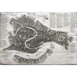
Plan von Venedig.
A scarce plan of Venice. With an extensive key naming more than 100 places on the map.
Place & Date: Germany, ca. 1800
Selling price: $120
Sold in 2020
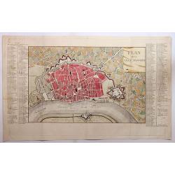
Plan von Amsterdam.
A small and attractive copper engraved plan of the city. Shows major buildings and the harbour filled with sailing ships.
Place & Date: Germany, ca. 1800
Selling price: $30
Sold in 2017
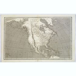
North America.
John Arrowsmith's map of North America at the turn of the nineteenth century. It shows very little exploration west of the Mississippi River, and 'Louisiana' stretches fr...
Place & Date: London, ca. 1800
Selling price: $45
Sold in 2017
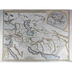
Partie Orientale de la Carte des Anciennes Monarchies.
This striking map depicts the eastern part of the Ancient World, including the Near East, Cyprus, Black Sea, Caspian Sea, Iran and Iraq. An inset map showing the eastern ...
Place & Date: Paris, ca 1800
Selling price: $45
Sold in 2017
![[Middle East Map]](/uploads/cache/98780-250x250.jpg)
[Middle East Map]
Very large map of the region north and east of the Mediterranean Sea. It covers the are from Eastern Italy to Western Persia, and from The Crimea to Egypt. It includes co...
Place & Date: England, ca. 1800
Selling price: $115
Sold in 2017
Map of the World as Known to the Ancients Shewing the Settlements of the Sons of Noah.
An interesting map of the ancient world showing Europe, North Africa and South Western Asia, by Thomas Conder (1747-1831) and was published in 1800 in London by C. Taylor...
Place & Date: London, 1800
Selling price: $30
Sold in 2017
Mappemonde a l'usage de l'instr.uction Par Guillaume Delisle et Philippe Buache et de l'Académie des Sciences Revue et Augmentée des N les Découvertes par Dézauche en 1800.
Rare late edition of the De L'Isle-Buache double hemisphere map of the world, first published in 1720 by De L'Isle and first revised by Buache in 1745. The map is a marve...
Place & Date: 1800
Selling price: $800
Sold in 2017
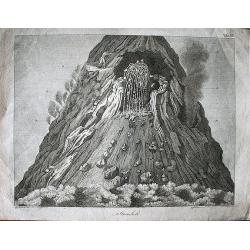
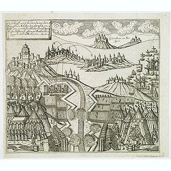
Stromboli.
From the famous book of Spallanzani Reise in beyden Sizilien a spectacular view of the volcanic area of the Italian island of Stromboli.
Place & Date: Leipzig, ca. 1800
Selling price: $90
Sold in 2021