Browse Listings
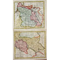
Carte de la Lithuanie, de la Courlande et de la Nouvelle Russie Blanche démembrée de la Pologne. / Carte des Province annexées a la Petite Pologne et de la Gallicie avec la Lodomerie démembrées de la Pologne.
Louis Brion de la Tour (1756-1823), French geographer. '' Atlas Géneral, Civil et Ecclésiastique'', 1766, '' Atlas Général'', 1790-98.Little map of Lithuania and Ukra...
Place & Date: Paris, 1802
Selling price: $210
Sold in 2010

Le Promerops Rayé. Pl.7.
A very rare print of a humming bird from Histoire naturelle et générale des colibris, oiseaux-mouches, jacamars et promerops , by Jean Baptiste Audebert. Before his dea...
Place & Date: Paris, 1800-1802
Selling price: $210
Sold in 2008
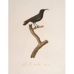
Le S. Violet. Pl.12
A very rare print of a humming bird from Histoire naturelle et générale des colibris, oiseaux-mouches, jacamars et promerops , by Jean Baptiste Audebert. Before his dea...
Place & Date: Paris, 1800-1802
Selling price: $360
Sold

Flower (Plate 632).
Plate from William Curtis (1746-1799) The Botanical Magazine. The publication began in February 1787 and was immediately successful, and the early volumes were quickly so...
Place & Date: London 1803
Selling price: $20
Sold

Flower (Plate 1117).
Plate from William Curtis (1746-1799) The Botanical Magazine. The publication began in February 1787 and was immediately successful, and the early volumes were quickly so...
Place & Date: London 1803
Selling price: $20
Sold

Flower (Plate 703).
Plate from William Curtis (1746-1799) The Botanical Magazine. The publication began in February 1787 and was immediately successful, and the early volumes were quickly so...
Place & Date: London 1803
Selling price: $20
Sold
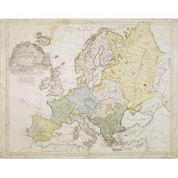
Europe
Very rare Ottoman printed map of Europe from Jedid Atlas Tercümesi or New Atlas, printed 1218 H. or 1803 in Üsküdar, a part of Istanbul. Title, scale and place names i...
Place & Date: Üsküdar, 1803
Selling price: $2300
Sold in 2011
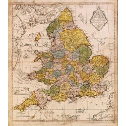
Map of England.
Very rare Ottoman printed map of the world in a Mercator projection, centered on Australia.From Jedid Atlas Tercümesi or New Atlas , printed 1218 H. or 1803 in Üsküdar...
Place & Date: Üsküdar, 1803
Selling price: $660
Sold
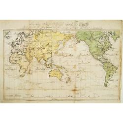
World map in Mercator's projection.
Very rare Ottoman printed map of the world in a Mercator projection, centered on Australia. From "Jedid Atlas Tercümesi or "New Atlas", printed 1218 H. or...
Place & Date: Üsküdar, 1803
Selling price: $5025
Sold
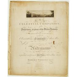
Cellestial Companion or projects in plano of the Starry..
Complete title: Celestial companion or projections in plano of the Starry heavens simple, original and useful: Accompanied by observations, explanatory of their use and a...
Place & Date: Islington 1803
Selling price: $1650
Sold
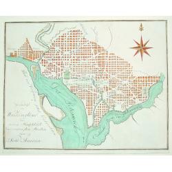
Grundrifs von Washington der nuen Hauptstadt ver vereinigten Staaten von Nord America
An extremely rare and desirable early plan of Washington DC. Of German origin, the map was published during Thomas Jefferson's first term as U.S. President. The work iden...
Place & Date: Heidelberg, c. 1803
Selling price: $800
Sold
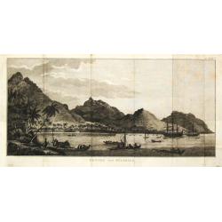
Gezigt van de stad en haven van St. Petrus en St. Paul aan Kamtschatka.
Captain James Cook (1728-79), explorer, circumnavigator and hydrographer. Three voyages, 1768-71, 1772-75 and 1776-79. From 1778 on printed editions of ' Captain Cook's T...
Place & Date: Leiden, 1795-1803
Selling price: $70
Sold
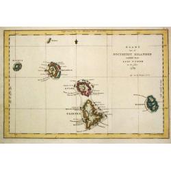
Kaart van de Societeit Eilanden.
Captain James Cook (1728-79), explorer, circumnavigator and hydrographer. Three voyages, 1768-71, 1772-75 and 1776-79. From 1778 on printed editions of ' Captain Cook's T...
Place & Date: Leiden, 1795-1803
Selling price: $120
Sold
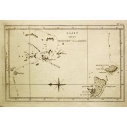
Kaart van de Vrienden-Eilanden.
Captain James Cook (1728-79), explorer, circumnavigator and hydrographer. Three voyages, 1768-71, 1772-75 and 1776-79. From 1778 on printed editions of ' Captain Cook's T...
Place & Date: Leiden, 1795-1803
Selling price: $100
Sold in 2008
Gezicht van Huaheine.
Captain James Cook (1728-79), explorer, circumnavigator and hydrographer. Three voyages, 1768-71, 1772-75 and 1776-79. From 1778 on printed editions of ' Captain Cook's T...
Place & Date: Leiden, 1795-1803
Selling price: $55
Sold in 2008
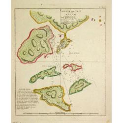
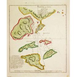
Schets van Typa of van Macao.
Captain James Cook (1728-79), explorer, circumnavigator and hydrographer. Three voyages, 1768-71, 1772-75 and 1776-79. From 1778 on printed editions of ' Captain Cook's T...
Place & Date: Leiden, 1795-1803
Selling price: $130
Sold
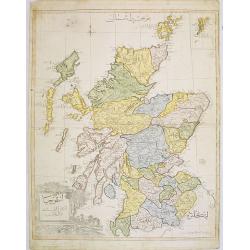
Scotland.
Very rare Ottoman printed map of Scotland with inset of Shetland Islands from Cedid Atlas Tercümesi or New Atlas , printed 1218 H. or 1803 in üsküdar, a part of Istanb...
Place & Date: Vienna/ Üsküdar, 1803
Selling price: $800
Sold in 2008
Kaart van het Eiland Otahiti.
Captain James Cook (1728-79), explorer, circumnavigator and hydrographer. Three voyages, 1768-71, 1772-75 and 1776-79. From 1778 on printed editions of ' Captain Cook's T...
Place & Date: Leiden, 1795-1803
Selling price: $100
Sold in 2008

Oude Gedenktekenen op het Paasch-Eiland.
Captain James Cook (1728-79), explorer, circumnavigator and hydrographer. Three voyages, 1768-71, 1772-75 and 1776-79. From 1778 on printed editions of \' Captain Cook\'s...
Place & Date: Leiden, 1795-1803
Selling price: $95
Sold in 2009
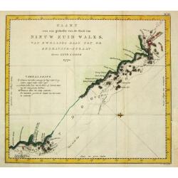
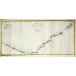
Kaart. . . van de kust van Nieuw Zuid Wales van Kwelling Kaap tot de Endeavour-Straat 1770.
A chart of the northeast coast of Australia from the northern extremity of Cape York peninsula with Endeavour Strait to the Endeavour River and present day Cooktown. From...
Place & Date: Leiden, 1795-1803
Selling price: $300
Sold
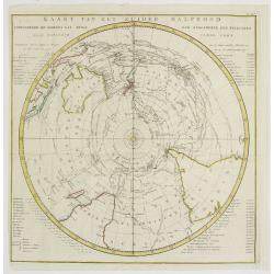
Kaart van het Zuider Halfrond..
A circular chart within a square frame centred on the southern pole.It shows southern parts of South America, South Africa and Madagascar as well as Australia and part of...
Place & Date: Leiden 1795-1803
Selling price: $500
Sold
Kaart van Nieuw Zuid Wales of de Oostlijke Kust van Nieuw Holland ontdekt?.J. Cook? 1770
A map of the east coast of Australia. Captain James Cook (1728-79), explorer, circumnavigator and hydrographer. Three voyages, 1768-71, 1772-75 and 1776-79. From 1778 on ...
Place & Date: Leiden, 1795-1803
Selling price: $750
Sold
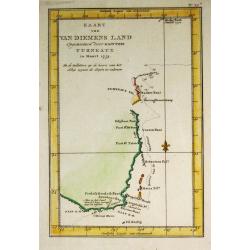
Kaart van Van Diemens Land.
A map of Tasmania surveyed by Captain James Cook (1728-79), explorer, circumnavigator and hydrographer.
Place & Date: Leiden, 1795-1803
Selling price: $150
Sold
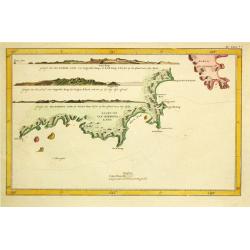
Kaart van Van Diemens Land.
A map of the southernmost part of van Diemens Land. After Captain James Cook (1728-79), explorer, circumnavigator and hydrographer. Three voyages, 1768-71, 1772-75 and 17...
Place & Date: Leiden, 1795-1803
Selling price: $160
Sold
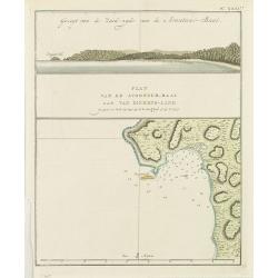
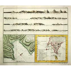
Gezicht van de Zuidzijde van de Avontur-Baai/ Plan van de Avontuur-Baai aan van Diemens-Land.
Captain James Cook (1728-79), explorer, circumnavigator and hydrographer. Three voyages, 1768-71, 1772-75 and 1776-79. From 1778 on printed editions of ' Captain Cook's T...
Place & Date: Leiden, 1795-1803
Selling price: $65
Sold in 2009
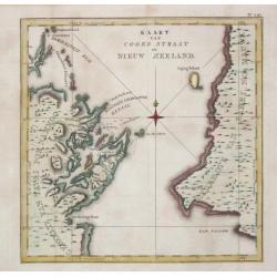
Kaart van Cooks Straat in Nieuw Zeeland.
Captain James Cook (1728-79), explorer, circumnavigator and hydrographer. Three voyages, 1768-71, 1772-75 and 1776-79. From 1778 on printed editions of \"Captain Coo...
Place & Date: Leiden, 1795-1803
Selling price: $225
Sold
Schets van Typa of van Macao.
Captain James Cook (1728-79), explorer, circumnavigator and hydrographer. Three voyages, 1768-71, 1772-75 and 1776-79. From 1778 on printed editions of "Captain Coo...
Place & Date: Leiden, 1795-1803
Selling price: $125
Sold in 2008
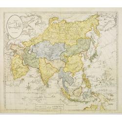
Asia.
Very rare Ottoman printed map of the world in a Mercator projection, centered on Australia.From Jedid Atlas Tercümesi or New Atlas , printed 1218 H. or 1803 in Üsküdar...
Place & Date: Üsküdar 1803
Selling price: $3100
Sold
General charte von Australien Nachdem neusten Entdeckungs Reisen..
Map of Australia, the S.W. Pacific, and Indonesia showing Australia lettered Neu Holland vormals Ulimaroa with separated Tasmania.
Place & Date: Weimar, 1803
Selling price: $800
Sold
Kaart van de Good Success Baai in de Straat van le Maire. / Kaart van het Z.O.gedeelte van het Vuurland de Straat Le Maire en een gedeelte van Staaten-Land 1769.
Captain James Cook (1728-79), explorer, circumnavigator and hydrographer. Three voyages, 1768-71, 1772-75 and 1776-79. From 1778 on printed editions of ' Captain Cook's T...
Place & Date: Leiden, 1795-1803
Selling price: $95
Sold in 2018

Northern part of Germany.
Very rare Ottoman printed map of northern part of Germany, including Hamburg, Bremen, Hanover, etc., from Jedid Atlas Tercümesi or New Atlas , printed 1218 H. or 1803 in...
Place & Date: Üsküdar, 1803
Selling price: $600
Sold
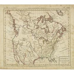
Amérique Septentrionale an XI 1803.
Curious map of North America taken from "Boussole des speculateurs". According to the title, an uncommon encyclopedical work should be useful for investors and ...
Place & Date: Paris, 1803
Selling price: $160
Sold in 2012
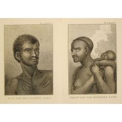
Vrouw / Man van van Diemens Land.
Captain James Cook (1728-79), explorer, circumnavigator and hydrographer. Three voyages, 1768-71, 1772-75 and 1776-79. From 1778 on printed editions of ' Captain Cook's T...
Place & Date: Leiden, 1795-1803
Selling price: $100
Sold in 2017
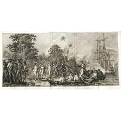
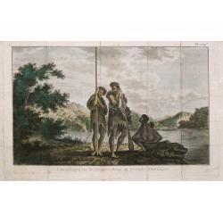
Landing op het eiland Tanna, een van de Nieuwe Hebriden.
Captain James Cook (1728-79), explorer, circumnavigator and hydrographer. Three voyages, 1768-71, 1772-75 and 1776-79. From 1778 on printed editions of Captain Cooks Trav...
Place & Date: Leiden, 1795-1803
Selling price: $70
Sold in 2008
Kaart van Van Diemens Land.
Captain James Cook (1728-79), explorer, circumnavigator and hydrographer. Three voyages, 1768-71, 1772-75 and 1776-79. From 1778 on printed editions of ' Captain Cook's T...
Place & Date: Leiden, 1795-1803
Selling price: $135
Sold in 2011
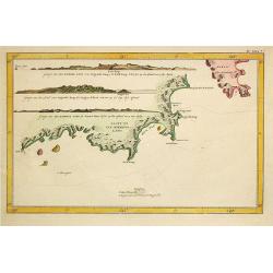
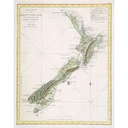
Kaart Van Nieuw Zeeland in de Jaaren 1769 en 1770 bezogt door den Luitenant J. Cook met het Schip De Endeavour.
A uncommon map of New Zealand.From the Dutch edition of Prevost's "L'Histoire Générale des Voyages". From 1778 on printed editions...
Place & Date: Leiden, 1795-1803
Selling price: $1100
Sold in 2008
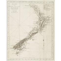
Kaart Van Nieuw Zeeland in de Jaaren 1769 en 1770 bezogt door den Luitenant J. Cook met het Schip De Endeavour.
A uncommon issue of this key map of New Zealand.From the Dutch edition of Prevost's "L'Histoire Générale des Voyages". From 1778 on printed editions of ' Capt...
Place & Date: Leiden, 1795-1803
Selling price: $1300
Sold in 2009
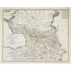
Charte der Leander am Caucasus nach dem besten vorhanden . . .
Very uncommon map of the Ukraine and Caucasus filled with great topographical detail, as well as numerous place names. According to the title the map has been drawn by Jo...
Place & Date: Vienna, 1803
Selling price: $600
Sold in 2011
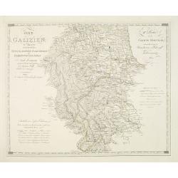
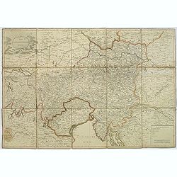
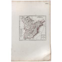
Ost Galizien, IVtes Blatt, enthaltend den Stanislowower Zaleszyker und Tschernowitzer Kreis. . . / IVeme Partie de la Galicie Orientale contenant les Cercles de Stanislawow, de Zaleszyk et de Tschernowitz. . .
Very detailed map of Galicia, Poland after the cartographic sources by Metzburg, Rizzi Zannoni and the Jesuit astronomer Joseph Liesganig. French Titles on the upper righ...
Place & Date: Vienna, Verlag des Kunst und industrie Comptoirs, 1803
Selling price: $400
Sold in 2010
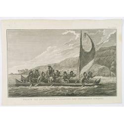
Praauw van de Sandwich's eilanden, met gemaskerde roeijers.
Decorative engraving of a Hawaiian proa, rowed by masked oarman. From a Dutch edition of Cook's voyages'.Captain James Cook (1728-79), explorer, circumnavigator and hydro...
Place & Date: Leiden, 1795-1803
Selling price: $50
Sold in 2020
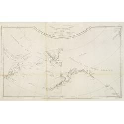
Kaart van de noord-west kust van Amerika en de noord-oost kust van Asia. Opgenoomen in de Jaaren 1778 en 1779.
Captain James Cook (1728-79), explorer, circumnavigator and Hydrographer. Three voyages, 1768-71, 1772-75 and 1776-79. From 1778 on printed editions of ' Captain Cook's T...
Place & Date: Leiden, 1795-1803
Selling price: $60
Sold in 2010
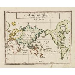
Charte der Erde. Augsburg beij John Walch.
Map showing the world in Mercator projection. Centered on Australia and New Zealand with the European continent is in the right of the map and the American continent in t...
Place & Date: Augsburg, 1803
Selling price: $80
Sold in 2011
![[No tittle] Ancienne N°3 Pologne. . .](/uploads/cache/30627-250x250.jpg)
[No tittle] Ancienne N°3 Pologne. . .
The most eastern section of a larger post road maps maps of Prussia and Poland prepared by David Gilly. (Section DIII). The map show the cities of Bialla, Warka, Warschau...
Place & Date: Berlin, Simon Schropp u. Comp., 1803
Selling price: $120
Sold in 2011
Carte d'une partie de la terre de Witt (à la nouvelle-Hollande) 3ème feuille. . .
Map of the Western Australian coastline from Cape Leveque to Lesueur Island showing tracks of "Le Geographe" in 1801 and 1803 and "Le Casuarina" in 18...
Place & Date: Paris, 1803
Selling price: $400
Sold in 2011
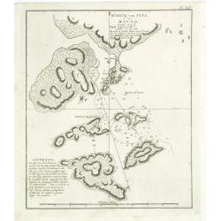
Schets van Typa of van Macao.
A map of Macao and the islands in its vicinity. From a Dutch edition of "Cook's voyages ".Captain James Cook (1728-79), explorer, circumnavigator and hydrograph...
Place & Date: Leiden, 1795-1803
Selling price: $130
Sold in 2011
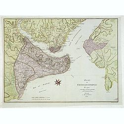
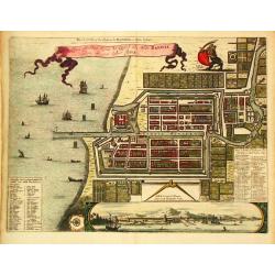
Plan de Constantinople leve par - F. Kaufer et I. B. Lechevalier. A Weimar au Burau d'Industrie 1803.
Large plan of Constantinople, the Golden Horn, the Bosporus and Scutari on the Asian side. With many engraved details, streets, villages, mosques, etc. The area outside t...
Place & Date: Weimar, Industrie Comptoire, 1803
Selling price: $500
Sold in 2015
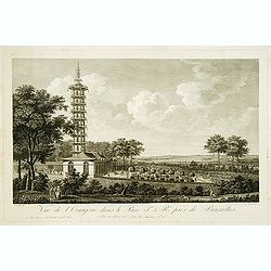
Vue de l'Orangerie dans le Parc J. & R(oya)l. prés de Brussels.
Copper engraving by Lorieux after a design of S. Le Febre. Showing the Orangerie at a parc near Brussels. Published by Tessari & Co.
Place & Date: Paris, Tessari, 1803
Selling price: $100
Sold in 2017

Ière Vue du Palais Impérial & Royal, près de Bruxelles.
Copper engraving by Lorieux after a design of S. Le Febre. Showing the Imparial Palace near Brussels. Published by Tessari & Co.
Place & Date: Paris, Tessari, 1803
Selling price: $80
Sold in 2017
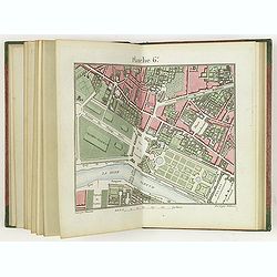
Plan de la ville de Paris dressé géométriquement d'après celui de la Grive, avec ses changements et augmentations.
Charming book forming a plan of Paris engraved by Perrier Oncle and written by Pelicier. Beautiful copy in very fresh colors.
Place & Date: Paris, 1803
Selling price: $1500
Sold in 2020
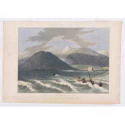
Tripoli.
Showing a few boats and harbour of Tripoli in Libanon, sketched on the spot by F.B. Spilsbury and drawn by D. Orme for "Picturesque Scenery in the Holy Land and Syri...
Place & Date: London, 1803
Selling price: $30
Sold in 2022
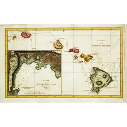
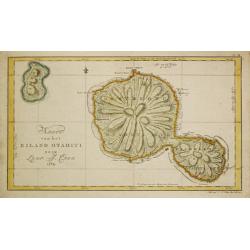
Kaart van de Sandwich eilanden.
A close copy of James Cook's first map of Hawaii. It shows Cook's tracks through the archipelago, including dates, topographical features of the islands and a large inset...
Place & Date: Leiden, 1795-1803
Selling price: $315
Sold in 2021
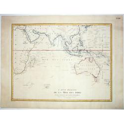
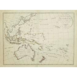
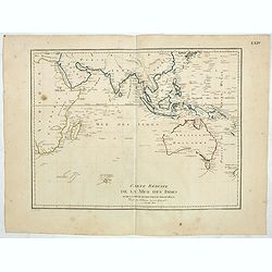
Carte Reduite de la Mer des Indes et de la Partie Occidentale du Gran Ocean. 1803.
An important chart of the south seas, showing Australia with the discoveries made by James Cook on the east coast, and Nicholas Baudin, also including current knowledge o...
Place & Date: Paris, 1803
Selling price: $410
Sold in 2021
Der Osterreichische Kreiss. Nach dem neusten Grenz=Berichtigung verlast.
Folding map of Austria, engraved by F. Reisser and published by Tranquillo Mollo in Vienna. Maria Laurentio Tranquillo Mollo (born August 10, 1767 in Bellinzona, Ticino, ...
Place & Date: Vienna, 1803
Selling price: $95
Sold in 2013
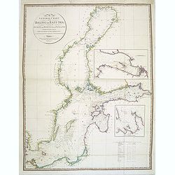
A General Chart of the Baltic or East Sea, including the Gulfs of Botnia and Finland . . .
Detailed and scarce chart of the Baltic and contiguous coasts, from Faden's general atlas. With two insets of the areas around Revel and St. Petersburg.Engraved by Neele ...
Place & Date: London, June 1803
Selling price: $350
Sold in 2014
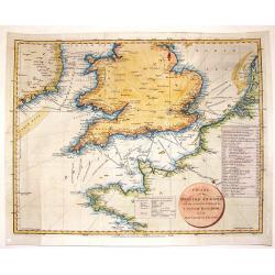
Chart of the British Channel with the Opposite Coast of the United Kingdom and the Republic of France.
Finely detailed chart of the English Channel from the east coast of Ireland to France. With a circular title cartouche and two tables, one that lists the dates of invasio...
Place & Date: London, 1803
Selling price: $41
Sold in 2016
Inboorlingen van de Donkere-Baai op Nieuw-Zeeland.
Captain James Cook (1728-79), explorer, circumnavigator and hydrographer. Three voyages, 1768-71, 1772-75 and 1776-79. From 1778 on printed editions of ' Captain Cook's T...
Place & Date: Leiden, 1795-1803
Selling price: $60
Sold in 2019
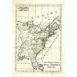
Gli Stati Uniti dell'America.
A rare map of the United States of America, from "Nuova geografia universale antica e moderna cosmografica, fisica, topografica, di commercio e d'industria politica,...
Place & Date: Rome, Vincenzo Poggioli, 1803
Selling price: $200
Sold in 2020
![[2 maps] Des europäischen Russlands nördlicher Theil. / Des europäischen Russlands sûdlicher Theil.](/uploads/cache/35343-250x250.jpg)
[2 maps] Des europäischen Russlands nördlicher Theil. / Des europäischen Russlands sûdlicher Theil.
Detailed map of Russia in two sheets, published by Johannes Wach of Augsburg.
Place & Date: Augsburg, 1803
Selling price: $200
Sold in 2015
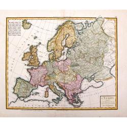
L'Europe Divisee en Ses Principaux Etats et D'Apres le Traite de Paix de Luneville.
Place & Date: Paris, 1803
Selling price: $66
Sold in 2016
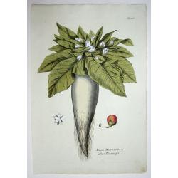
Atropa Mandragora L./ Die Alraunapfel.
Orginal colored copper engraving. paper size 48 x 33 cm; laid paper; watermarked. from: Icones plantarum medicinalium, Vienna, 1788-1803.Joseph Jacob Pleck (1735 - 1807)...
Place & Date: Vienna, 1788-1803
Selling price: $50
Sold in 2015
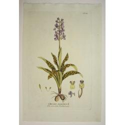
Orchis Mascula L./ Das maennliche Knabenkraut.
Orginal colored copper engraving. paper size 48 x 33 cm; laid paper; watermarked. from: Icones plantarum medicinalium, Vienna, 1788-1803. Joseph Jacob Pleck (1735 - 1807...
Place & Date: Vienna, 1788-1803
Selling price: $50
Sold in 2015

Narcissus Pseudo-Narcissus L./ Die unaechte Narzisse.
Orginal colored copper engraving. paper size 48 x 33 cm; laid paper; watermarked. from: Icones plantarum medicinalium, Vienna, 1788-1803. Joseph Jacob Pleck (1735 - 1807...
Place & Date: Vienna, 1788-1803
Selling price: $72
Sold in 2015
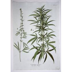
Cannabis Sativa. Der zahme Hanf. (Cannabis!)
Orginal colored copper engraving. paper size 48 x 33 cm; laid paper; watermarked. from: Icones plantarum medicinalium, Vienna, 1788-1803. Joseph Jacob Pleck (1735 - 1807...
Place & Date: Vienna, 1788-1803
Selling price: $121
Sold in 2015

Nicotiana Tabacum L./ Der gemeine Tobak.
Orginal colored copper engraving. paper size 48 x 33 cm; laid paper; watermarked. from: Icones plantarum medicinalium, Vienna, 1788-1803. Joseph Jacob Pleck (1735 - 1807...
Place & Date: Vienna, 1788-1803
Selling price: $50
Sold in 2015
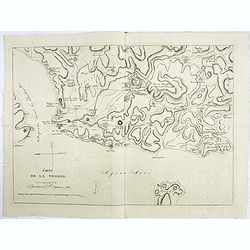
Carte de la Troade levée par les C. C. le Chevalier et L.F.Cassas en 1786.
Interesting map of Troad in Turkey and the Simois River. At the top is Mount Ida and the Egee Sea is at the bottom.Troy was a city situated in what is known from Classica...
Place & Date: Paris, 1803
Selling price: $50
Sold in 2022

Phoenix Dactylifera./ Die Gemeine Dattelpalme. (Date Palm Tree)
Original colored copper engraving. paper size 48 x 33 cm; laid paper; watermarked. From: 'Icones plantarum medicinalium', Vienna, 1788-1803. Joseph Jacob Plenck (1735-180...
Place & Date: Vienna, 1788-1803
Selling price: $50
Sold in 2015
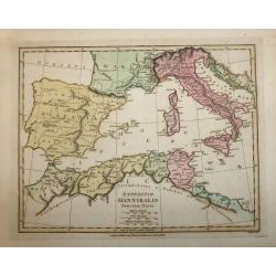
EXPEDITIO HANNIBALIS POENORUM DUCIS
A copper engraved map by John Roper which was published in "Wiklinson's Atlas Classica" in 1803. The map covers the Mediterranean & Islands, Tunisia, Spain,...
Place & Date: London, 1803
Selling price: $50
Sold in 2016
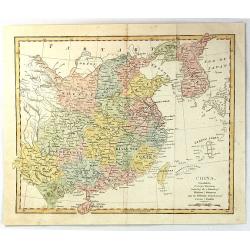
China, Contains 15 Subject Provinces Including the 2 Islands of Hainan, Formosa and the Tributary Kingdoms of Corea, Tonkin
An antique hand colored map from Wilkinson's "A General Atlas, being a Collection of Maps of the World and Quarters the Principal Empires, Kingdoms &c. with thei...
Place & Date: London, 1803
Selling price: $60
Sold in 2016
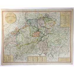
Charte von Helvetien und Wallis.
A pleasing map of Switzerland and Northern Italy. Detailed topography with mountains, rivers and lakes. The mapmaker was Goetze from Weimar in 1803. Four informational i...
Place & Date: Weimar, 1803
Selling price: $22
Sold in 2016
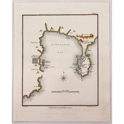
Gibraltar Bay.
A striking map of Gibraltar and Gibraltar Bay with Old Gibraltar across the bay by T. Walsh, and engraved by S. Neele.From “Journal of the Late Campaign in Egypt: Inclu...
Place & Date: London, 1803
Selling price: $31
Sold in 2017
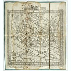
Hamburg.
Plan of the city of Hamburg, drawn up and published by C.L.B. Mirbeck in London, engraved by B. Baker.
Place & Date: London, 1803
Selling price: $36
Sold in 2022
ETATS UNIS DE L' AMERIQUE.
A scarce early, original outline colored map of the United States, showing 17 organised states. Georgia still extends to the Mississippi River, shortly before the organis...
Place & Date: Paris, 1803
Selling price: $40
Sold in 2019
Carte reduite de la Mer des Indes et de la partie occidentale du Grand Océan. (Page XXIV)
Uncommon map of the Indian Ocean, Australia and the East Coast of Asia, showing still an incomplete coastline for Australia and New Guinea, among other features. The map ...
Place & Date: Paris, 1803
Selling price: $260
Sold in 2019
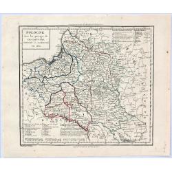
Pologne avec les Partages de 1792, 1793 et 1795 . . .
A striking map of Poland, Lithuania and Prussia with notes on the region. The notes within the map show the acquisitions of Russia in Poland in 1773 and 1795, totaling 14...
Place & Date: Paris, 1803
Selling price: $59
Sold in 2019
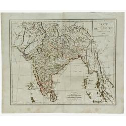
Carte de L'Inde.
A scarce engraved map of the Indian subcontinent covering India and including parts of Iran (Perse), Afghanistan (Royaume de Candahar), Tibet, China, and Indochina (Empir...
Place & Date: Paris, 1803
Selling price: $120
Sold in 2021
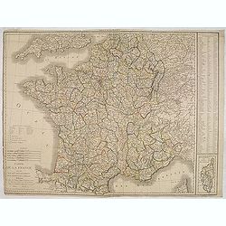
Carte de la France divisée en 108 departemens. . .
General map of France, showing a road-system and 108 departments. In lower right inset map of Corsica (140x70mm.) The map is dated 1804 and "An 12" being the 12...
Place & Date: Paris, An 12 / 1804
Selling price: $40
Sold
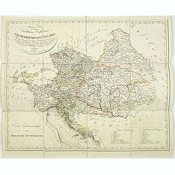
Allgemeine Charte zur Uebersicht der Kirchlichen Verfassung des oesterreichischen Staates = Carte eccle´siastique de la monarchie autrichienne : mit Bemerkung aller Erzbisthu¨mer. . .
Detailled map showing Central Europe and showing the Austria-Hungarian Monarchy. The map includes Austria, with parts of Poland, Germany, Italy, prepared by Karl Joseph K...
Place & Date: Vienna, Kunst und Industrie Comptoirs,1804
Selling price: $135
Sold in 2013
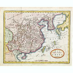
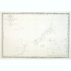
Map of China.
Showing China, Taiwan and Korea, divided into provinces with the main cities marked. The map is of interest for the naming of the sea between Korea and Japan, here called...
Place & Date: London, 1804
Selling price: $300
Sold in 2014
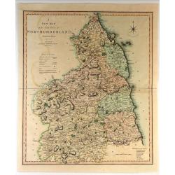
A New Map of the County of Northumberland Divided into Wards.
Handsome and detailed county map shows market towns with distances from London in measured miles. The major canals, roads, railways, parks and churches are also clearly m...
Place & Date: London, 1804
Selling price: $31
Sold in 2018
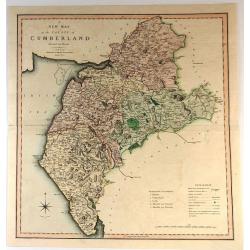
A New Map of the County of Cumberland
Handsome and detailed county map shows market towns with distances from London in measured miles. The major canals, roads, railways, parks and churches are also clearly m...
Place & Date: London, 1804
Selling price: $15
Sold in 2017