Browse Listings
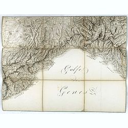
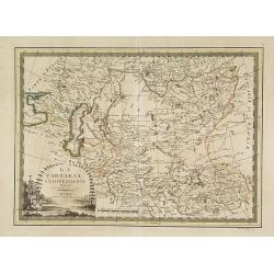
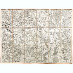
(Separate sheet from ) Carte générale du théâtre de la guerre en Italie et dans les Alpes.
The complete title of the map is "Carte générale du théâtre de la Guerre en Italie et dans les Alpes depuis le passage du Var le 29 septembre 1792 jusqu'à l'ent...
Place & Date: Milan, 1798
Selling price: $50
Sold in 2017
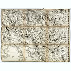
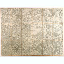
(Separate sheet from ) Carte générale du théâtre de la guerre en Italie et dans les Alpes.
The complete title of the map is "Carte générale du théâtre de la Guerre en Italie et dans les Alpes depuis le passage du Var le 29 septembre 1792 jusqu'à l'ent...
Place & Date: Milan, 1798
Selling price: $45
Sold in 2016
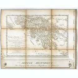
(Separate sheet from ) Carte générale du théâtre de la guerre en Italie et dans les Alpes.
The complete title of the map is "Carte générale du théâtre de la Guerre en Italie et dans les Alpes depuis le passage du Var le 29 septembre 1792 jusqu'à l'ent...
Place & Date: Milan, 1798
Selling price: $30
Sold in 2016
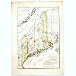
Maine entworfen von D.F. Sotzmann. Hamburg bey Carl Ernst Bohn 1798 . . . NO.VII
Extremely rare map of Maine prepared by Daniel Friedrich Sotzmann for Christopher Ebeling's "Erdbeschreibung von Amerika", a project ended after only ten maps o...
Place & Date: Hamburg, Carl Ernst Bohn, 1798
Selling price: $4600
Sold in 2016
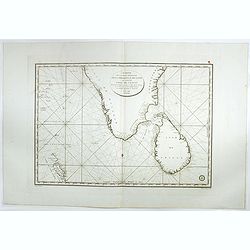
Carte de la partie Méridionale dela presque'isle de L'Inde qui comprend L'Isle de Ceylan. . . 1798.
Large focused on southern part of India and Sri Lanka. Showing villages, banks, isles and soundings made in meters.Chart was prepared by Vice Admiral Rosili and publishe...
Place & Date: Paris, after 1798
Selling price: $300
Sold in 2017
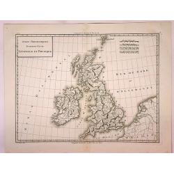
Isles Britanniques Premiere Carte Generale et Physique.
A detailed copper engraving map of the British Isles by Mentelle and Chanlaire from their "Atlas Universel". Published in Paris in 1798. The map shows mountains...
Place & Date: Paris, 1798
Selling price: $21
Sold in 2017
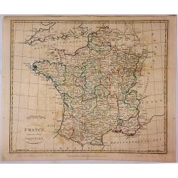
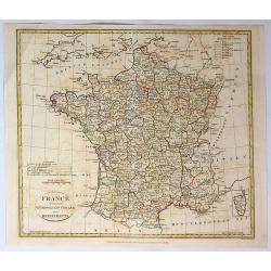
France Divided Into Provinces.
A fine map of France with outline color delineating the provinces. Published in London in 1798 by G.G. & J Robinson, and engraved by S. Neele.
Place & Date: London, 1798
Selling price: $12
Sold in 2017
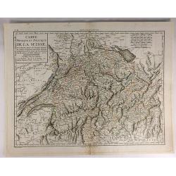
Carte Physique et Politique de la Suisse.
A finely engraved map of Switzerland issued in an “Atlas Universel de Géographie Physique et Politique, Ancienne et Moderne”, which was published in by Mentelle and...
Place & Date: Paris, 1798
Selling price: $70
Sold in 2017
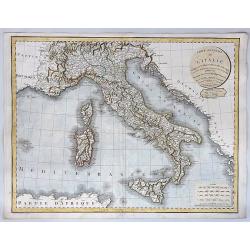
Carte Generale de L'Italie Redigee Sur les Observations les Plus Authentiqueues.
A decorative and large format map of Italy from the age of Napoleon. Produced by Delamarche in 1798. Charles Delamarche (1740-1817) entered the mapmaking industry as succ...
Place & Date: Paris, 1798
Selling price: $35
Sold in 2018
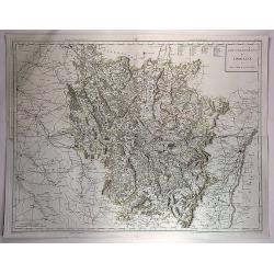
Gouvernements de Lorraine et Des Trois Eveches.
A large, detailed copper engraving map of the province of Lorraine, France by Mentelle and Chanlaire, from their "Atlas Universel". Published in Paris in 1798.
Place & Date: Paris, 1798
Selling price: $10
Sold in 2018
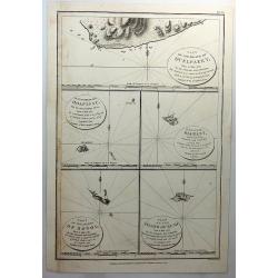
Part of the Island of Quelpaert, Hoapinsu, Dagelet, Botol & Kumi.
A fine copper engraved chart with inserts of the Islands of Quelpaert, Hoapinsu, Dagelet, Botol & Kumi. From Ls Perouse’s ATLAS DU VOYAGE DE LA PEROUSE. Published ...
Place & Date: London, 1798
Selling price: $32
Sold in 2018
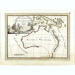
La Nuova Olanda e La Nuova Guinea delineate sulle ultima osservazioni.
Cassini’s splendid and rare map of Australia and New Guinea, from the 'Nuovo Atlante Geografico Universale'. The emphasis of the map is the charting of Captain Cook dow...
Place & Date: Rome, 1798
Selling price: $4100
Sold in 2018
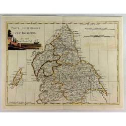
Parte Settentrionale Dell Inghilterra.
A fine Italian map of the northern part of England. It features a title cartouche "Siena 1795 Near Pazzini Carli". The sheet comes from the rare geographical At...
Place & Date: Siena, 1798
Selling price: $125
Sold in 2020
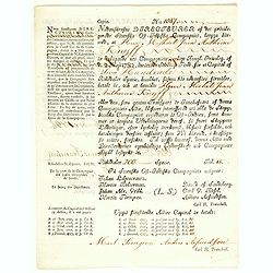
(Very rare share in the Swedish East India Company. ) N° 1087.
Very rare share in Swedish East India Company for Michael Jean Anthoine Knijff for 200 Riksdaelders. With a printed translation in French in the left hand margin.More abo...
Place & Date: Gotheborg, 28 September,1798
Selling price: $850
Sold in 2018
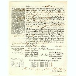
(Very rare share in the Swedish East India Company. ) N° 1086.
Very rare share in Swedish East India Company for Michael Jean Anthoine Knijff for 200 Riksdaelders. With a printed translation in French in the left hand margin. More ab...
Place & Date: Gotheborg, 28 September,1798
Selling price: $900
Sold in 2018
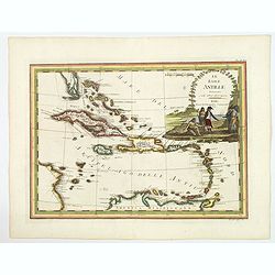
Le Isole Antille Delineate Sulle Ultime Observazioni.
A scare map of Caribbean, that includes the southern tip of Florida, which is shown as an archipelago, the Bahamas, and the northern coast of Venezuela, including Artiba ...
Place & Date: Rome, 1798
Selling price: $405
Sold in 2020
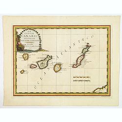
Le Isole Canarie Delineate Sulle Ultime Osservazioni.
A scarce map of the Canaries, from Cassini's atlas the Nuovo Atlante Geografico Universale. Enhanced with a large decorative title cartouche, and a pair of mileage scales...
Place & Date: Rome, 1798
Selling price: $100
Sold in 2023
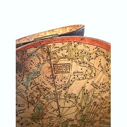
A Correct Globe with the new Discoveries. / A Correct Globe with y(e) New Constelations of Dr. Halley &c.
>A charming pocket globe with a diameter of 7 cm (3 inch) held in the publisher's shark skin case with two metal clasps. The design after Moll's pocket globe, Cook's d...
Place & Date: England, ca. 1775-1798
Selling price: $3600
Sold in 2020
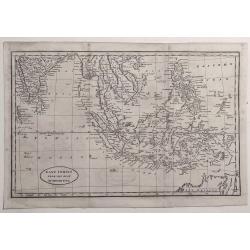
East Indies from the Best Authorities.
Striking map of the East indies extending from India to the Philippines, including Malaysia, Java, Sumatra, Borneo and the north of New Holland (Australia). Engraved by R...
Place & Date: London, 1798
Selling price: $50
Sold in 2021
![[A Manuscript map and 3 town views of Malta and Valletta.]](/uploads/cache/24469-250x250.jpg)
[A Manuscript map and 3 town views of Malta and Valletta.]
A manuscript map of Malta and Gozo in French, topped by a panoramic view of Valetta with the Knight's ships in the foreground (Veue de la Cité Valette du costé du grand...
Place & Date: Malta, ca.1768 - 1798
Selling price: $27500
Sold
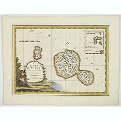
L'Isola O-Taiti scoperta dal Cap. Cook, con le Marchesi di Mendoza.
This an example of Cassini's wonderful map made in order to celebrate the visit to Tahiti by the English Captain James Cook, during his scientific mission to observe the ...
Place & Date: Rome, 1798
Selling price: $110
Sold in 2020
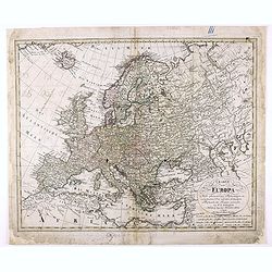
Charte von Europa Nach den neuesten Astronomischen Ortsbestimmungen entworfen und berichtiget auf der Sternwarte Seeberg, bey Gotha. . .
Nice map of Europa.
Place & Date: Nuremberg, 1798
Selling price: $72
Sold in 2020
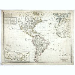
Carte de L'Amerique ..
Fine detailed map of America, with inset map of the Northern regions, including Alaska. Prepared by J.B.Poirson and Herison. Upper left hand corner 2 blocks listing the f...
Place & Date: Paris, 1798
Selling price: $300
Sold in 2022
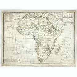
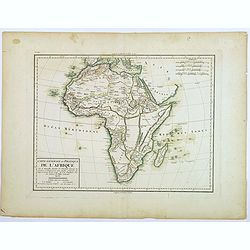
Carte d'Afrique
Fine detailed map of Africa. Prepared by J.B.Poirson and Herison. Upper left hand corner 2 blocks listing the foreign English, Dutch, Spanish, Portuguese and Danish posse...
Place & Date: Paris, 1798
Selling price: $110
Sold in 2022
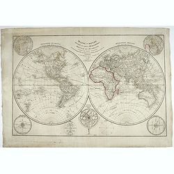
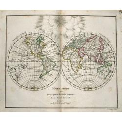
Mappe-monde divisée en deux hémisphères, oriental et occidental, assujetties aux dernières découvertes de Mrs de Bougainville, Surville, Cartret. Wallis, Furneau, Cook, etc, Par J.-B. Poirson...
Fine detailed world map in double hemispheres. Prepared by J.B.Poirson and Herison. According to the title the map is updated with info from travels by de Bougainvill...
Place & Date: Paris, 1798
Selling price: $200
Sold in 2022
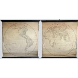
Map of the World on a Globular Projection, Exhibiting Particularly the Nautical Researches of Capn. James Cook, F.R.S. . .
A monumental world map by Aaron Arrowsmith showing the world at the time of the second British Empire. The two hemispheres are on a large scale and hence reveal incredibl...
Place & Date: London, 1799
Selling price: $3000
Sold in 2019
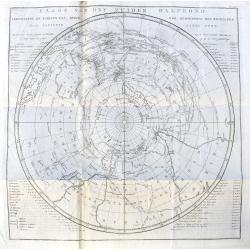
Kaarat van het Zuider Halfrond. . .
A Dutch edition of this important map from Cook's voyages. Not as commonly found as the English versions. It is centred on the South Pole, and it shows the southern hemis...
Place & Date: Leiden, ca. 1799
Selling price: $101
Sold in 2020
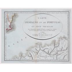
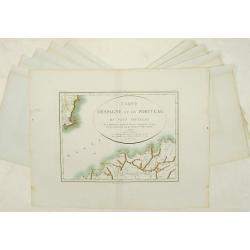
Carte D'Espagne et de Portugal en Neuf Feuilles ...
Fine unusual 1799 Mentelle & Chanlaire's copper engraved map covering part of Murcia, south-eastern Spain, centered on Cartagena. The map covers also northern porti...
Place & Date: Paris, 1799
Selling price: $170
Sold in 2021
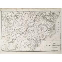
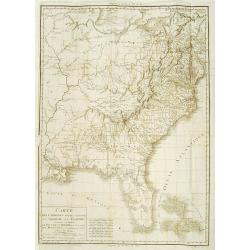
Carte des États-Unis, Provinces Méridionales.
The map shows portions of Kentucky, Virginia, Tennessee, Georgia, North Carolina, South Carolina, a strip of land between Tennessee and Georgia as 'United States Territor...
Place & Date: Paris, 1799
Selling price: $125
Sold in 2022
Carte dés Carolines Méridionale et septrionale La Georgie, la Floride.. Le pays des Cherokées ..
Fine map of Florida, Carolinas and Georgia. From : Voyage dans les parties sud de l'Amérique septentrionale, savoir : les Carolines septentrionale et méridionale, la G�...
Place & Date: Paris 1799
Selling price: $650
Sold
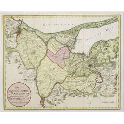
Karte von Danzig, Elbing und Marienburg odert..
Uncommon map centered on Danzig and Elbing. Very detailed, prepared by Johann Fridrich Endersch (1705-1769). Engraved by A.Amon.
Place & Date: Vienna, 1799
Selling price: $600
Sold in 2009
Carte d'Espagne et de Portugal en neuf feuilles.
Together forming a large wall map (970x126cm) of Spain and Portugal.
Place & Date: Paris, 1799
Selling price: $800
Sold
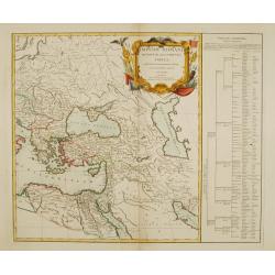
Imperii Romani occidentis..
Detailed map of the eastern part of the roman Empire showing Greece, Near East, Egypt and Libya. Very decorative title cartouche surrounded with roman legion's arms and e...
Place & Date: Paris 1799
Selling price: $160
Sold
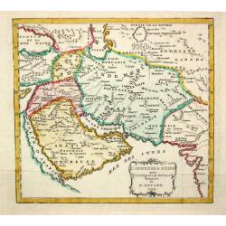
L' Armenie & Medie.
A map depicting Arabia in ancient times.
Place & Date: London, 1799
Selling price: $90
Sold
Atlas portatif universel.
Edited by : "Au dépôt de Géographie, Rue Geoffroy Langevin, N° 328. Se trouve A Paris au Bureau de l'Atlas National, Rue de la Harpe, N° 26. Et chez tous les Ma...
Place & Date: Paris, de Pellier, 1799
Selling price: $4100
Sold
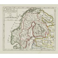
Royaumes de Suede et de Norwege..
Small general map of Scandinavia. From Atlas Portatif Universel, by Robert de Vaugondy.Page 8 outside border top right. Mary Sponberg Pedley does not mention a state with...
Place & Date: Paris, ca. 1748-1799
Selling price: $100
Sold in 2019
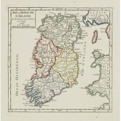
Isle et Royaume d'Irlande.
Nice small map of Ireland. From Atlas Portatif Universel, by Robert de Vaugondy.Page 7 outside border top right. Mary Sponberg Pedley does not mention a state without dat...
Place & Date: Paris, 1748-1799
Selling price: $70
Sold
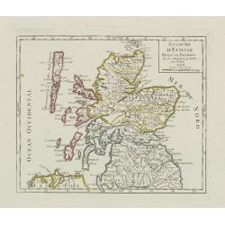
Royaume d\'Ecosse.
Nice small map of Scotland. From Atlas Portatif Universel, by Robert de Vaugondy.Page 6 outside border top right. Mary Sponberg Pedley does not mention a state without da...
Place & Date: Paris, 1748-1799
Selling price: $50
Sold in 2008
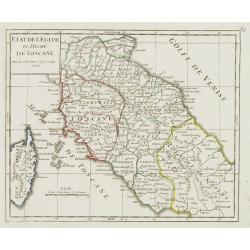
Etat de l'Eglise et Duché de Toscane.
Detailed small map of central Italy, including most part of Corsica. From Atlas Portatif Universel, by Robert de Vaugondy.Unrecorded state with page 59 outside border top...
Place & Date: Paris, 1799
Selling price: $150
Sold in 2008
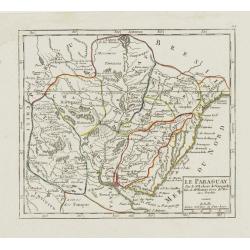
Le Paraguay.
Nice small map covering the basin drained by the main tributaries of the Río de la Plata (the Uruguay and Paraná, and the important Paraná...
Place & Date: Paris, 1799
Selling price: $80
Sold in 2009
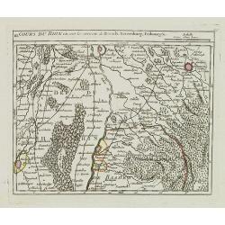
III. Cours du Rhin où sont les environs de Brisach, Newenburg, Fribourg &c.
Small detailed map illustrating the stretch of the Rhine which flows between Nuremburg and Breisach am Rhein.From Atlas Portatif Universel, by Robert de Vaugondy.Page 34c...
Place & Date: Paris, 1799
Selling price: $20
Sold in 2021
La Tartaria indipendente. . .
Map of Central Asia from the eastern shore of the Black Sea to the borders of China, with Georgia, the Caspian Sea, Turkestan, Usbekistan, Samarkand, Bokhara, Tibet and B...
Place & Date: Rome, 1799
Selling price: $300
Sold in 2009
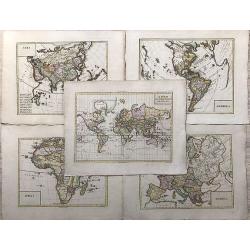
Atlas élémentaire, composé de 31 Cartes. . .
An attractive Atlas with 31 copper engraved double-page maps of the World after Vaugondy. Title, preface, table, 112 interesting text pages. Contains a double hemisphere ...
Place & Date: Paris, 1799
Selling price: $500
Sold in 2012
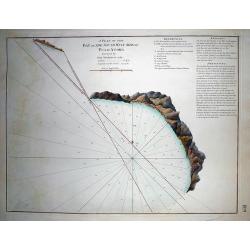
A Plan of the Bay on the South West Side of Pulo Auore...
VERY RARE from "The country East-India Pilot" published in 1799 by Laurie & Whittle. Important copper engraved map of the Bay on this island near Singapor...
Place & Date: London, 1799
Selling price: $95
Sold in 2011
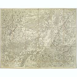
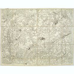
Kriegs Theater der teutschen und franzoesischen Graenzlanden zwischen dem Rhein und der Mosel, im Jahr 1796 : drittes Blatt.
Very detailed map of Pfalz from a six-sheet map prepared by Peter Dewarat, with a dedication by Johann Ludwig Christian Rheinwald, (1763 - 1811) who was a lawyer and hist...
Place & Date: D. Artaria, Mannheim, 1795-1799
Selling price: $50
Sold in 2013
Kriegs Theater der teutschen und franzoesischen Graenzlanden swischen dem Rhein und der Mosel, im Jahr 1797 : viertes Blatt.
Very detailed map of Pfalz from a six-sheet map prepared by Peter Dewarat, with a dedication by Johann Ludwig Christian Rheinwald, (1763 - 1811) who was a lawyer and hist...
Place & Date: D. Artaria, Mannheim, 1794-1799
Selling price: $50
Sold in 2013
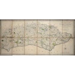
A Topographical Map of the County of Sussex Reduced from the Large survey in four sheets by Thomas Gream. . .
Folding Map of Sussex engraved on paper laid onto linen, with 6 folds, 380 x 800mm opened out, Scale: 6 miles to 2.5 inches. The map has original hand-coloring showing ...
Place & Date: London, 1799
Selling price: $200
Sold in 2016
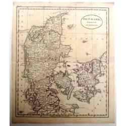
Denmark From the Best Authorities.
Finely detailed map of Denmark and Holstein by Russell.
Place & Date: London, 1799
Selling price: $23
Sold in 2016
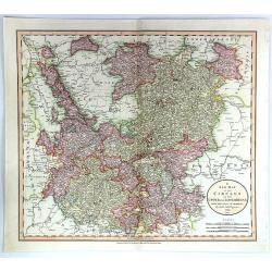
A New Map of the Circles of the Upper and Lower Rhine
A detailed, hand-colored antique map by the prominent English cartographer John Cary in London in 1799, covering an area from Westphalia and Lower Saxony in the north to ...
Place & Date: London, 1799
Selling price: $21
Sold in 2019
Der Schwaebische Nebst den Oesterreichischen Besizungen in Schwaben.
A fine detailed map of Swabia in southern Germany with small inset map of the Principality of Lichtenstein. Also includes parts of Austria and Switzerland. By Johann Walc...
Place & Date: Augsburg, 1799
Selling price: $15
Sold in 2016
(World Map plus Continents) WORLDMAP - A' FOLD OT RESZEINEK LERAJZOLASA. + AMERIKA. - AFRIKA. - ASIA. - EUROPA.
Very rare set of Hungarian maps publ. in "Oskolai Magyar Uj Atlas" (=Hungarian New School Atlas). Copper engravings.WORLDMAP - A' FOLD OT RESZEINEK LERAJZOLASA....
Place & Date: Debrecen, ca 1799
Selling price: $901
Sold in 2018
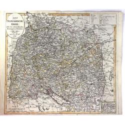
Cercle de Franconie divisé en ses princip.ux Etats.
Small detailed map of the northern part of Bavaria. From Atlas Portatif Universel, by Robert de Vaugondy.Edited by : "Au dépôt de Géographie, Rue Geoffroy Langevi...
Place & Date: Paris, 1799
Selling price: $15
Sold in 2019
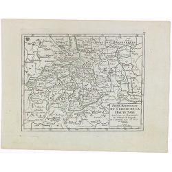
Partie Meridionale du Cercle de la Haute Saxe..
Small detailed map of part of Germany, approximatively corresponding to the today states of Thüringen, Saxony and Saxony-Anhalt.Showing Berlin in the upper part. From At...
Place & Date: Paris, 1799
Selling price: $15
Sold in 2020
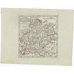
France Divided Into Metropolitan Circles and Departments.
A fine map of France divided into Metropolitan Circles and Departments by the English map publisher Clement Cruttwell. The French Department system was established in 179...
Place & Date: London, 1799
Selling price: $14
Sold in 2018
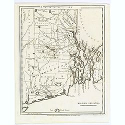
Rhode Island.
This small but striking map of Rhode Island is from Payne's Geography, published by John Low. Counties, roads, ponds, rivers, swamps, and towns and cities are shown. Unen...
Place & Date: New York, 1799
Selling price: $85
Sold in 2017
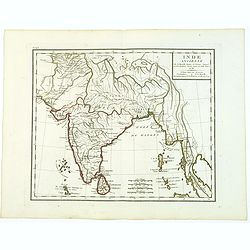
Inde Ancienne.
Map of ancient India in attractive out-line color. Shows from modern day Pakistan eastwards and southwards down to Thailand, the Nicobar and the Andaman Islands, includes...
Place & Date: Paris, 1799
Selling price: $50
Sold in 2017
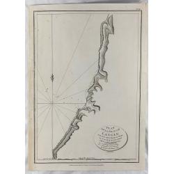
Plan of la Baie de Langle.
A simple map of the bay on the west shore of Sakalin Island. Relief shown by hachures. From the English edition that was published in London by G.G. & J. Robinson in ...
Place & Date: London, 1799
Selling price: $20
Sold in 2018
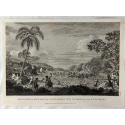
Massacre of De Langle, Lemanon & Ten Others of the Two Crews.
Engraved battle scene with native Samoans using rocks with slings and clubs. Published in London by G.G. & J. Robinson in 1799. Engraved by Neele. Jean-Francois de Ga...
Place & Date: London, 1799
Selling price: $41
Sold in 2018
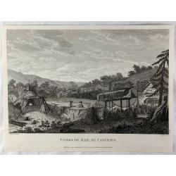
Tombs of Baie de Castries.
An interesting engraving of tombs in the Baie de Castries, in the Okhotsk Sea in eastern Russia. Published in London by G.G. & J. Robinson in 1799. Engraved by Heath....
Place & Date: London, 1799
Selling price: $26
Sold in 2018
Kriegs Theater der teutschen und franzoesischen Graenzlanden swischen dem Rhein und der Mosel, im Jahr 1797 : viertes Blatt.
Very detailed map of Pfalz from a six-sheet map prepared by Peter Dewarat, with a dedication by Johann Ludwig Christian Rheinwald, (1763 - 1811) who was a lawyer and hist...
Place & Date: D. Artaria, Mannheim, 1794-1799
Selling price: $50
Sold in 2020
Kriegs Theater der teutschen und franzoesischen Graenzlanden swischen dem Rhein und der Mosel, im Jahr 1796 : drittes Blatt.
Very detailed map of Pfalz from a six-sheet map prepared by Peter Dewarat, with a dedication by Johann Ludwig Christian Rheinwald, (1763 - 1811) who was a lawyer and hist...
Place & Date: D. Artaria, Mannheim, 1794-1799
Selling price: $50
Sold in 2019
Kriegs Theater der teutschen und franzoesischen Graenzlanden swischen dem Rhein und der Mosel, im Jahr 1796 : zweites Blatt.
Very detailed map of Pfalz with Mainz from a six-sheet map prepared by Peter Dewarat, with a dedication by Johann Ludwig Christian Rheinwald, (1763 - 1811) who was a lawy...
Place & Date: D. Artaria, Mannheim, 1794-1799
Selling price: $50
Sold in 2019
Kriegs Theater der teutschen und franzoesischen Graenzlanden swischen dem Rhein und der Mosel, im Jahr 1796 : erstes Blatt.
Very detailed map of Pfalz from a six-sheet map prepared by Peter Dewarat, with a dedication by Johann Ludwig Christian Rheinwald, (1763 - 1811) who was a lawyer and hist...
Place & Date: D. Artaria, Mannheim, 1794-1799
Selling price: $50
Sold in 2019
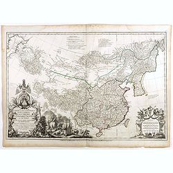
Carte la plus generale et qui comprend la Chine, la Tartarie chinoise et le Tibet. . .
With a quite elaborately pictorial cartouche, engraved by Guelard, the map was engraved by the master engraver Guillaume-Nicolas de la Haye (1727 -1802). Very detailed ma...
Place & Date: Paris, Dezauche, 1789–1799
Selling price: $3100
Sold in 2018
A New Map, of the World. with all the New Discoveries. By Capt. Cook and other Navigators Ornamented with the Solar System the Eclipses of the Sun Moon & Planets &c. by T. Kitchen Geographer. London, 1799.
This very rare and unrecorded double-hemisphere world map, with an unusually dark etched border containing the title cartouche, astronomical illustrations ( circular diag...
Place & Date: London, 1799
Selling price: $8550
Sold in 2018
IX. Carte du C.té de Haynaut où sont les environs de Philippeville, Marienbourg, Rocroix &c.
Attractive small map showing an area straddling the border between France and Belgium. It shows Philippeville, Marienbourg, Rocroi, Couvin and Chimay.From Atlas Portatif ...
Place & Date: Paris, 1799
Selling price: $15
Sold in 2020
Carte Generale et Politique de L'Afrique.
A French republic map of Africa, from the Atlas National, published in Paris in the last year of the eighteenth century. The map highlights numerous mountain ranges, lake...
Place & Date: Paris, 1799
Selling price: $40
Sold in 2020
A Map of The Kingdom of Poland and Grand Dutchy of Lithuania including Samogitia and Curland, divided into their Dismemberments. . .
A scarce, second edition map of Poland by William Faden published in London in 1799. The map itself is based on the Rizzi-Zannoni 24-sheet map of 1772, that was commissio...
Place & Date: London, 1799
Selling price: $190
Sold in 2019
Syriae sive soriae.
A fine map of Syria showing the Anatolian Mountains to the north, the coastline with Alexandria, Tripoli, Antioch and Tyro in the south. The map extends inland to show th...
Place & Date: Amsterdam 17th
Selling price: $220
Sold

Rose à cent feuilles - Rosa contifolia L.
A bouquet of Roses. Engraved by P.F. Le Grand after designs by the Dutch-born Gerard van Spaendonck (1746-1822).Taken from the rare work "Fleurs dessinées d'après ...
Place & Date: Paris, c.1800
Selling price: $220
Sold in 2022

Tulipe des Jardins. Tulipa gesneriana. L.
Tulips, stipple engraving by P.F. Le Grand after designs by the Dutch born (1746-1822).Taken from the rare work "Fleurs dessinées d'après nature. . . receuil util...
Place & Date: Paris, c.1800
Selling price: $450
Sold in 2013
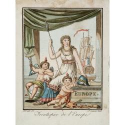
Frontispice de l'Europe.
Decorative title page with heraldic figures and large ship with French flag. One putti sitting on a globe and holding the scepter of Mercury.
Place & Date: Paris, 1800
Selling price: $140
Sold in 2014

Pivoine double. Poenia officinalis. L.
A bouquet of Double-Pivoine roses, engraved by P.F. Le Grand after designs by the Dutch born (1746-1822).Taken from the rare work "Fleurs dessinées d'après nature...
Place & Date: Paris, c.1800
Selling price: $300
Sold in 2013
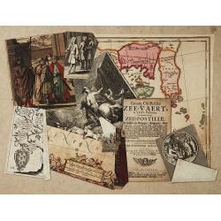
Trompe l?oeil.
Including fragments of Blaeu's map of China, showing Korea and part of China's main land. A title page of ''Groote Christelijke Zee-vart, in XXVI Predicatien.. (Amsterdam...
Place & Date: Netherlands c.1800
Selling price: $350
Sold
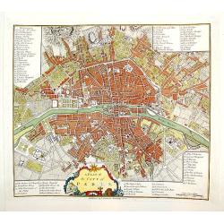
A Plan of the City of Paris.
A handsome and finely engraved plan of Paris based on late 18th century information. The work contains three legends identifying 78 points of interest, including major la...
Place & Date: London, dated 1800
Selling price: $340
Sold

Pavot cultivé. Papaver somniferum. L.
Bouquet of poppy flowers, engraved by P.F. Le Grand after designs by the Dutch born (1746-1822).Taken from the rare work "Fleurs dessinées d'après nature. . . rec...
Place & Date: Paris, c.1800
Selling price: $200
Sold in 2013

Jacinthe double. Hyacinthus orientalis. L.
Bouquet of hyacinth flowers, stipple engraving by P.F. Le Grand after designs by the Dutch born (1746-1822).Taken from the rare work "Fleurs dessinées d'après nat...
Place & Date: Paris, c.1800
Selling price: $225
Sold in 2013
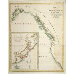
Karte von .. Norstwestlichen Kuste America.
A very nice map centered on Northwest coast of America, including the city of Vancouver. On the lower left corner, an inset map (285x208 cm) of Japan, Taiwan and Chinese ...
Place & Date: Berlin 1800
Selling price: $510
Sold
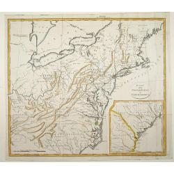
Part of the United States of North America.
Fine map of the eastern part of the United States, with in lower right an inset of South Carolina. An entirely new engraving, closely copied from the 1798 English edition...
Place & Date: Berlin 1800
Selling price: $250
Sold
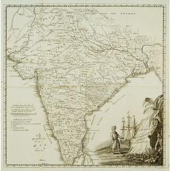
Charte von Indostan.
Rare map of India, with imposing title cartouche lower right. Engraved by Gustav Georg Endner (1754-1824).
Place & Date: Leipzig 1800
Selling price: $240
Sold