Browse Listings
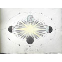
Four Astronomical Diagrams (manuscript atlas).
A well executed manuscript of celestial charts and diagrams. Copernican system, Tychonic system, Ptolemaic system, planets (Uranus called Herschel), the seasons, lunar an...
Place & Date: Unknown, ca 1800
Selling price: $250
Sold in 2018
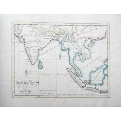
A Book of Maps (manuscript atlas).
A well executed manuscript atlas with four maps: Canaan; Travels of the Apostles; Missionary Stations in India; Europe. Of particular interest is the map of South East As...
Place & Date: Unknown, ca 1800
Selling price: $250
Sold in 2018
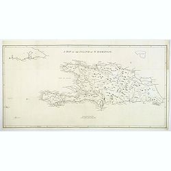
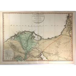
A Map of the Island of St. Domingo.
An important map of the Caribbean island of St. Domingo (Santo Domingo), or Hispaniola, prepared by Bryan Edwards and published by Englishman John Stockdale in 1800. This...
Place & Date: London, 1800
Selling price: $85
Sold in 2018
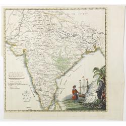
Charte von Indostan.
Rare map of India, with imposing title cartouche lower right. Engraved by Gustav Georg Endner (1754-1824).
Place & Date: Leipzig, 1800
Selling price: $150
Sold in 2018
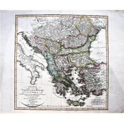
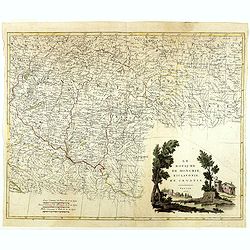
Charte vom Türkischen Reiche in Europa / nach den neuesten astronomischen Ortsbestimmungen entworfen. . .
A large, decorative map of central and south Europa showing the possessions of the Ottoman Empire in Europe in the year 1800.
Place & Date: Weimar, 1800
Selling price: $140
Sold in 2019
![[Set of 4 plans] Ichonographia urbis antique Ravenne / Sunbridge Place, Bore Place and Sharps Place, the seats of John Hyde / Icon urbis Caesenae / Lilla in Flandra.](/uploads/cache/43026-250x250.jpg)
[Set of 4 plans] Ichonographia urbis antique Ravenne / Sunbridge Place, Bore Place and Sharps Place, the seats of John Hyde / Icon urbis Caesenae / Lilla in Flandra.
[Set of 4 European city plans] - Ichonographia urbis antique Ravenne (Ravenna in Italy) - Sunbridge Place, Bore Place and Sharps Place, the seats of John Hyde in England ...
Place & Date: Amsterdam, Paris, ca 1783 - 1800
Selling price: $50
Sold in 2019
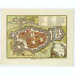
A Plan of the City of Turin.
An attractive small town plan of Turin, published in London at the beginning of the nineteenth century in John Stockdale's "Plans of the Principal Cities of the Worl...
Place & Date: London, 1800
Selling price: $50
Sold in 2020
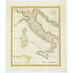
Italy with the Islands of Sicily, Sardinia & Corsica Drawn from the Best Authorities.
Antique copperplate map of Italy, and surrounding countries, together with the islands of Sicily, Sardinia & Corsica. Regions named. With a plain title and a mileage ...
Place & Date: London, ca 1800
Selling price: $48
Sold in 2019
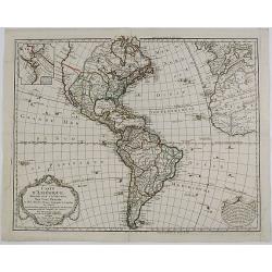
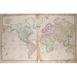
Carte d'Amérique, Dressée pour Instruction. . .
Dezauche's revision of the De l'Isle/Buache map of North and South America which first came out in 1722. This is rare 1800 issue. The map reflects the political changes i...
Place & Date: Paris, 1800
Selling price: $350
Sold in 2019
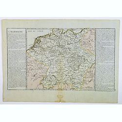
L'Allemagne.
A map of Germany of French origin, published in the late eighteenth or early nineteenth centuries, has informative and interesting text panels on either side. The map con...
Place & Date: Paris, ca 1800
Selling price: $20
Sold in 2021
Ursa Major; Leo Minor.
This celestial chart shows the Big Dipper, which makes the Bear's hindquarters and tail. Below Ursa Major is Leo Minor, the Smaller Lion. With numerous stars and informat...
Place & Date: BERLIN, 1801
Selling price: $1000
Sold in 2012
![[Sheet one of "Carte Reduite De La Carte Generale D'Allemagne"]](/uploads/cache/26339-250x250.jpg)
[Sheet one of "Carte Reduite De La Carte Generale D'Allemagne"]
Top left sheet of a large folding nine-sheet map of Germany prepared by Jean Baptiste Hippolyte, baron Chauchard and published by Jean-Claude Dezauche (1745?-1824)Showing...
Place & Date: Paris, 1801
Selling price: $105
Sold in 2013
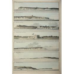
Five colored plates from the `Little Sea Torch'or, ‘True guide for coasting pilots:'
Published in Serres's scarce marine pilot, 'The Little Sea Torch', an acknowledged English edition of Bougard's 'Le Petit Flambeau de la Mer', although extensively revise...
Place & Date: London, 1801
Selling price: $300
Sold in 2013
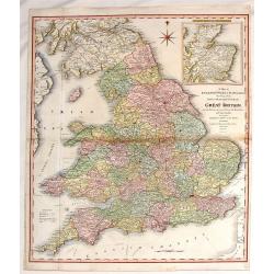
A Map of England, Wales & Scotland
With an inlay of a portion of Scotland, this map depicts all the direct and principal crossroads. There is an interesting compass rose. William Faden (1750 - 1836) was ...
Place & Date: London, 1801
Selling price: $11
Sold in 2015
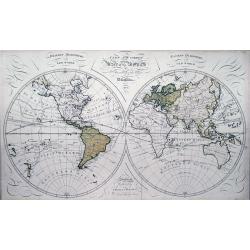
A new and correct chart of World according to the latest discoveries.
Scarce double hemisphere map of the world from Thomas Brown's General Atlas: *Includes the tracks of Captain Cook, Wallis, Anson, and the route from Manila to Acapulco *...
Place & Date: Edinburgh, 1801
Selling price: $330
Sold in 2013
A new and accurate Chart of the World according to Mercator's projections.
Rare map of the world with interesting features: *Includes the tracks of Captain Cook *Tasmania is attached to Australia *Curious shapes of northern Russian coasts *Nort...
Place & Date: Edinburgh, 1801
Selling price: $32
Sold in 2014
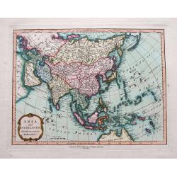
Asia and its Islands, from the most recent Authorities.
A fine, small but detailed map, showing Asia, a tip of Australia named New Holland, and a small part of Alaska. With numerous areas, rivers, and islands named. Includes m...
Place & Date: London, 1801
Selling price: $160
Sold in 2015
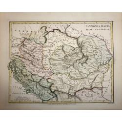
Pannonia, Dacia, Illyricum et Moesia.
A copper engraved map by John Roper, published in "Wilkinson's Atlas Classica" in 1801. The map covers the ancient Roman provinces of Pannonia, Dacia, Illyricum...
Place & Date: London, 1801
Selling price: $50
Sold in 2016
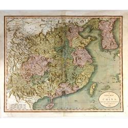
A New Map of China, From the Latest by John Cary
A beautiful example of John Cary's important 1801 map of China and Korea. Offers extraordinary detail including the great Wall of China. Also identifies the Island of Tai...
Place & Date: London, 1801
Selling price: $250
Sold in 2015
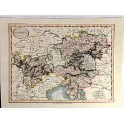
Austria By John Cary
A fine map of Austria and Slowenia. John Cary (1754 –1835) was an English cartographer. He served his apprenticeship as an engraver in London, before setting up his own...
Place & Date: London, 1801
Selling price: $95
Sold in 2015
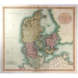
A New Map of the Kingdom of Denmark, Comprehending North and South Jutland, Zeeland, Fyen, Laaland, and Part of Holstein
A striking map of the region, colored by its provinces. It shows towns, roads, rivers, lakes, mountains, islands, etc. The map offers great detail and color coding accor...
Place & Date: London, 1801
Selling price: $35
Sold in 2016
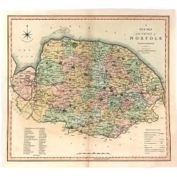
A New Map of the County of Norfolk Divided into Hundreds.
Large size, decorative map of the County of Norfolk by Jones, Smith & Co. for Smith's New English Atlas. The first map of the County to show longitudes measured from ...
Place & Date: London, 1801
Selling price: $14
Sold in 2016
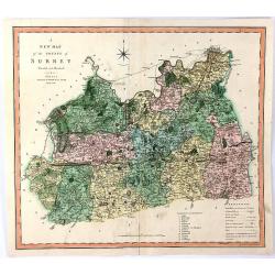
A New Map of the County of Surrey Divided Into Hundreds
A large sized, decorative map of the English County of Surrey by Jones, Smith & Co. for Smith's “New English Atlas”. This is the first map of the County to show l...
Place & Date: London, 1801
Selling price: $15
Sold in 2016
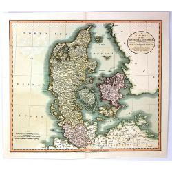
A New Map of the Kingdom of Denmark, Comprehending North and South Jutland, Zeeland, Fyen, Laaland, and Part of Holstein
An attractive, very detailed map of Denmark. Covers Jutland and the islands of Zeeland, Fyen, Laaland. Also includes most of the Duchy of Holstein and parts of Lower Saxo...
Place & Date: London, 1801
Selling price: $46
Sold in 2016
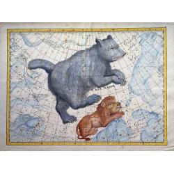
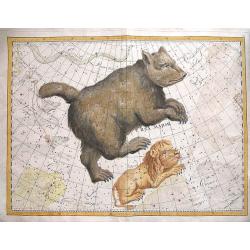
Ursa Major Constellation (Big Dipper)
A rare and extraordinary 1801 Johann Elbert Bode elephant folio celestial, constellation, or star map of Ursa Major (the Great Bear or Big Dipper) and Leo Minor. Consider...
Place & Date: Berlin, 1801
Selling price: $950
Sold in 2020
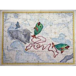
Pisces constellation
A rare and extraordinary 1801 Johann Elbert Bode elephant folio celestial, constellation, or star map of Pisces.Considered the largest and most dramatic celestial maps of...
Place & Date: Berlin, 1801
Selling price: $950
Sold in 2020

The Shepherd.
A fine mezzotint engraving entitled “THE SHEPHERD” by W. Benard from a painting by George Morland in London in 1801. Published in London by Barnard.
Place & Date: London, 1801
Selling price: $60
Sold in 2017

La vaccine aux prises avec la Faculté.
Rare satirical print on the controversy over vaccination: a cow at left charges at a donkey dressed in academic dress. The plate was deposited on 8 July 1801 by Argaud de...
Place & Date: Paris, July 1801
Selling price: $150
Sold in 2023
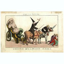
Gare la Vaccine - Triomphe de la petite Vérole.
Rare satirical print on the controversy over vaccination. "A diseased woman turning into a mermaid, a physician with a lancet riding on a cow and an apothecary wield...
Place & Date: Paris, c.1801
Selling price: $150
Sold in 2021

La vaccine ou l'inoculation a la mode.
Rare satirical print on the controversy over vaccination published in Paris " A Paris chez Depeuille Rue des Mathurins Sorbonne aux deux Pilastre d'Or".A child ...
Place & Date: Paris, 1801
Selling price: $175
Sold in 2020
![[Titlepage] Atlas Maritime.](/uploads/cache/05113-250x250.jpg)
[Titlepage] Atlas Maritime.
Uncommon title page from "Atlas Maritime" by Ivone Gravier active in Genoa. In lower margin "Chez Yves Gravier Libraire a Génes".The engraving depict...
Place & Date: Genoa, 1801
Selling price: $350
Sold in 2011
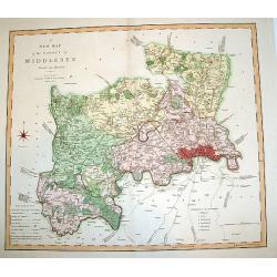
A New Map of the County of Middlesex.
A beautifully engraved and well-detailed turn of the 19th century map of County Middlesex, England. The metropolis of London and its environs are nicely highlighted, and ...
Place & Date: London, dated 1801
Selling price: $305
Sold in 2008
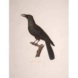
Le Calibée.
An attractive representation of a bird by François Levaillant in 1801. From Histoire naturelle d'une partie d'oiseaux nouveaux et rares de l'Améerique et des Indes : ou...
Place & Date: Paris 1801
Selling price: $200
Sold in 2008

L\'Ara Militaire. Pl. 4.
Superb representation of a parrot belonging to the species of the Military Macaw (Ara militaris) which occupies a massive but fragmented range from Mexico to Argentina.Fr...
Place & Date: Paris, 1801
Selling price: $370
Sold in 2008
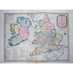
The invasions of England and Ireland with all their civil Wars since the Conquest.
Very interesting map showing the British Isles with their invasions and battles. Invasions (or attempts) are shown by small sailing ships, explained with text and the dat...
Place & Date: London, 1801
Selling price: $135
Sold in 2012
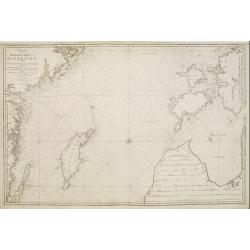
Charta öfver Medlersta Delen af Östersjön..
Uncommon chart centred on the Baltic Sea, giving good detail of the south-eastern coast of Sweden with the Gotland island, part of the coast of Latvia and Estonia with th...
Place & Date: Stockholm 1801
Selling price: $400
Sold
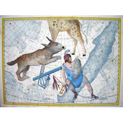
Lynx, Telescopium Herschelii, Auriga.
Bode's influental "Uranographia" was on of the greatest achievements in the Golden Age of celestial cartography. This charts shows many stars and nebulaes but m...
Place & Date: BERLIN, 1801
Selling price: $1200
Sold
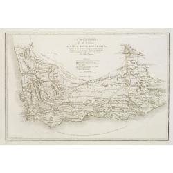
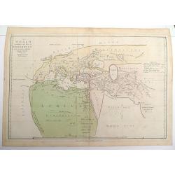
Carte générale de la colonie du Cap de Bonne Espérance.. Par John Barrow.
A very nice and rare map of the tip of South Africa, showing Cape of Good Hope. From Voyage dans la partie méridionale de l'Afrique: fait dans les années 1797 et 1798. ...
Place & Date: France c.1801
Selling price: $310
Sold
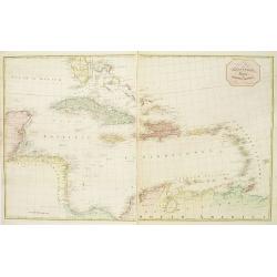
A new map of the West Indies.. (2 sheets)
A large scale and detailed map of the West Indies made by Bryan Edwards, a Jamaican planter and politician, for this 1793 publication describing the West Indies. The map ...
Place & Date: London c.1793-1801
Selling price: $1450
Sold
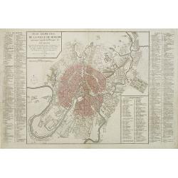
Plan géométral de la ville de Moscow ancienne capitale de l'empire de Russie. . .
Uncommon and detailed town-plan of the city of Moscow. To the left and right numbered keys to the most important spots in town. The lettered key stating the different Str...
Place & Date: Paris, 1801
Selling price: $1850
Sold in 2009
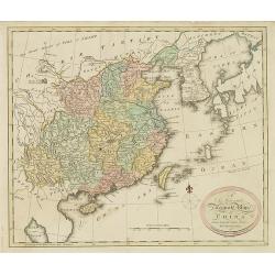
A new and Accurate map of China. . .
Map of China, including Taiwan and Korea. Engraved and published by Thomas Brown, who was active as map seller in Edinburg. Engraved by Gavin and son.From Brown's seldom ...
Place & Date: Edinburgh, 1801
Selling price: $1035
Sold in 2010
![[Title page] Nuovo Atlante geografico universale. . .](/uploads/cache/04049-250x250.jpg)
[Title page] Nuovo Atlante geografico universale. . .
Attractively engraved frontispiece. Atlas carries the world on his shoulders, four figures representing the continents, while Europe sits enthroned in the foreground.Titl...
Place & Date: Rome, 1792 - 1801
Selling price: $250
Sold in 2019
Neuest Post Karte von Deutschland und dessen angrenzenden Ländern. . .
A uncommon post road mapspost route map of Germany, Poland, Austria, Switzerland and the Low countries. Highly detailed map, showing post offices with the intermediate di...
Place & Date: Berlin, 1801
Selling price: $80
Sold in 2013
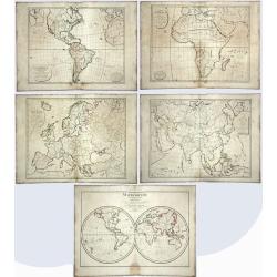
Mappemonde pour l'instruction, / Carte d'Europe pour l'Instruction / Carte d'Afrique Pour l'Instruction, / Carte d'Amérique, Pour l'Instruction. /
Five antique maps, blank with no names written, produced for educational purposes. One showing the world and the four continents: America, Europe, Asia, Africa. Mappemond...
Place & Date: Paris, 1801
Selling price: $113
Sold in 2020
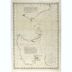
Kaart van Basses Straat, tusschen Nieuw Zuid Wales en Van Diemens-Land ... Heer Flinders ... 1798-1799. . .
A fine chart of Tasmania and the southern part of Australia with the Bass Strait, with the Hunters Islands and the Furneauz Islands, and the southernmost part of the Aust...
Place & Date: Leyden, Amsterdam & The Hague: Honcoop, Allart & van Cleef, 1795-1801
Selling price: $1200
Sold in 2021
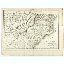
Carte de la partie méridionale des Etats-Unis.
Detailed 1801 map of North and South Carolina, Kentucky, Tennessee and Virginia. A separate publication of Pierre François Tardieu.With in lower left corner the address:...
Place & Date: Paris, 1801
Selling price: $200
Sold in 2022
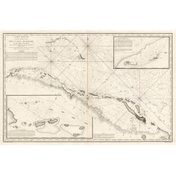
Carte Reduite d’une partie du Vieux Canal de Bahama...
This large highly detailed chart of the northern coastline of Cuba and part of the Bahamas was published under the auspices of the Contra-Amiral Decres Ministre de la Mar...
Place & Date: Paris, 1801
Selling price: $300
Sold in 2023
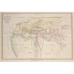
Ancient World according to Herodotus c1802.
An 1802 version of Herodotus's map of the world engraved by E. Bourne Published by R Wilkinson, No58 Cornhill London October 1st 1802.
Place & Date: London, 1802
Selling price: $40
Sold in 2012
Voyage de découvertes, a l'Océan Pacifique du nord, et autour du monde...
A rare French octavo edition of George Vancouver's explorations during the years 1790-1795, first published in 1797, the present work published in Paris in the year 1800 ...
Place & Date: Paris, 1802
Selling price: $990
Sold in 2019
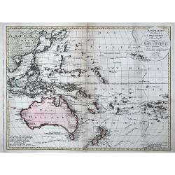
Australien (Südland) auch Polynesien oder Inselwelt. . .
FIRST EDITION of Johann Walch map of Australasia and the South Pacific. Australia still indicated as Neu Holland . Inserted in the map the routes followed by Cook, Byron,...
Place & Date: Augsburg, 1802
Selling price: $550
Sold in 2013
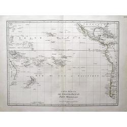
Carte reduite du Grand Ocean partie meridionale.
Scarce map of the South Pacific by Poirson. Shows Australia (Nouvelle Hollande) with unfinished coast line. Includes New Zealand, Hawaii, and large parts of the Americas....
Place & Date: Paris, 1802
Selling price: $200
Sold in 2013
La parte meridionale della Russia Europea in Roma 1802
Scarce map of European part of Russia, with Crimea in lower left corner.
Place & Date: Italy, ca. 1802
Selling price: $150
Sold in 2013
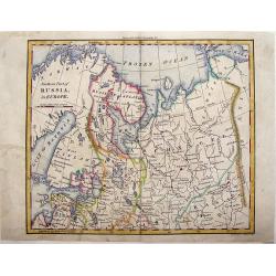
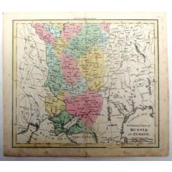
Northern Part of Russia in Europe.
Striking little map of the Northern part of Western Russia by William Darton. Published by Vernor & Hood in 1802 in London in "ATLAS TO WALKER'S GEOGRAPHY".
Place & Date: London, 1802
Selling price: $27
Sold in 2018
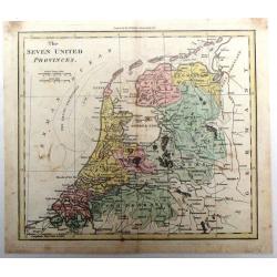
The Seven United Provinces.
Fine hand-colored map of The Netherlands engraved by William Darton from Walker's Geography in London in 1802. William Darton, Sr. started his map-making business in 178...
Place & Date: London, 1802
Selling price: $15
Sold in 2018
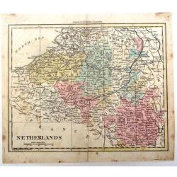
Netherlands.
Detailed map of the Netherlands by William Darton Jr. It is from Walker's Geography and is decorated with original coloring.
Place & Date: London, 1802
Selling price: $30
Sold in 2016
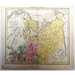
Northern Part of Russia in Europe.
Detailed map of the "Northern Part of Russia in Europe" by William Darton Jr. It is from Walker's Geography and is decorated with original coloring.
Place & Date: London, 1802
Selling price: $125
Sold in 2015
Southern Part of Russia in Europe.
Detailed map of the "Southern Part of Russia in Europe" by William Darton Jr. It is from Walker's Geography and is decorated with original coloring.
Place & Date: London, 1802
Selling price: $125
Sold in 2015
Ancient World according to Herodotus.
An 1802 version of Herodotus's map of the world engraved by E. Bourne Published by R Wilkinson, No58 Cornhill London October 1st 1802.Double page map.
Place & Date: London, 1802
Selling price: $65
Sold in 2016
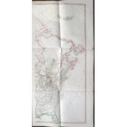
A Map Exhibiting all the New Discoveries in the Interior Parts of North America...
Published between 1795 and 1824, Aaron Arrowsmith's map of North America, is perhaps the single most important maps of North America after the American Revolution. It rep...
Place & Date: London, 1802
Selling price: $1400
Sold in 2020
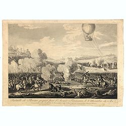
Bataille de Fleurus gagnée par l'arme´e française le 8 messidor de l'an 2 : commandée par les géneéraux Jourdan, Le Fevre, et Hatri : contre l'armée impériale commandée par Cobourg et Beaulieu. (N° 29).
After a design by Thomas-Charles Naudet. Engraved by Pierre-Adrien Le Beau. Print belonging to a suite illustrating the General Napoleon Bonaparte’s Campaigns. Read mor...
Place & Date: Paris, Jean, 1797 -1802
Selling price: $20
Sold in 2016
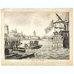
Prise de Malthe : le 24 prairial, an 6, 12 juin 1798. le général Bonaparte commandant la flotte française qui, par son ordre, avoit investi la capitale de cette isle et l'isle entière de tous les côtés, ...
Print belonging to a suite illustrating the General Napoleon Bonaparte’s campaigns.Read more about Napoléon Bonaparte [+]
Place & Date: Paris, chez Jean, 1797 -1802
Selling price: $425
Sold in 2016
Lower Egypt and the Adjacent Deserts, with a part of Palestine; to which has been added the Nomenclature of the Roman age
A pleasing map featuring the site of Napoleon’s campaign in Egypt, Palestine, and Syria, (1798-1801). Detail is given to the network of roads, rivers, and canals criss-...
Place & Date: London, 1802
Selling price: $114
Sold in 2020

Charles Bonnet, F.R.S., Author of the Contemplation of Nature
A portrait of Charles Bonnet, one of the best known naturalists of the 1700's.Bonnet is surrounded by "THE CHAIN OF NATURE" with 17 fine vignettes of animals an...
Place & Date: London, 1802
Selling price: $20
Sold in 2019
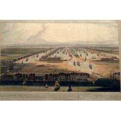
An Elevated View of the New Docks & Warehouses now constructing on the Isle of Dogs near Limehouse for the reception & accommodation of Shipping in the West India Trade,...
A fantastic bird's-eye view of the West India Docks, looking west towards the City of London. Very detailed with many sailing ships, buildings, and people on foot or hors...
Place & Date: London, 1802
Selling price: $175
Sold in 2016
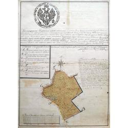
Subzow manuscript map.
An early manuscript map showing an area in or near Subzow in Tver Oblast, Russia. Subzow is located along the M9 highway from Moscow to Riga. This plan is possible a land...
Place & Date: ca. 1802
Selling price: $240
Sold in 2018
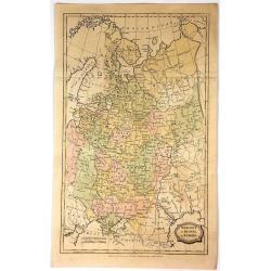
Muscovy or Russia in Europe.
Fine detailed engraved map of European Russia. It is from the "ENGLISH ENCYCLOPEDIA ...". The map is by George Kearsley and was engraved by Barlow. The Arctic o...
Place & Date: London, 1802
Selling price: $21
Sold in 2017
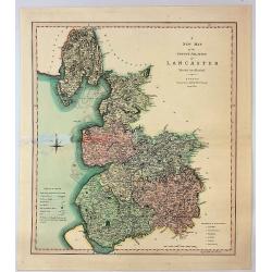
A New Map of the County Palatine of Lancaster Divided into Hundreds.
A large sized and decorative map of the county by Jones, Smith & Co. for Smith's "New English Atlas". The first map of the County to show longitudes measure...
Place & Date: London, 1802
Selling price: $14
Sold in 2017
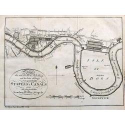
Plan des von der West Ind. Comp. auf der Isle of Dogs neu angelegten Staples u. Canals sowie des projectirten Londner Wasser-Stapels.
An unusual German plan of the proposed new docks in London: the West India Docks, St Katherine's & Greenland Dock. Also marked is Perry's Dock, at one time the bigges...
Place & Date: Weimar, ca. 1802
Selling price: $60
Sold in 2017
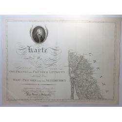
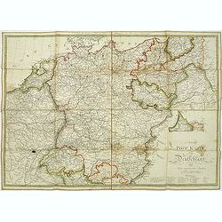
Karte von Ost-Preussen Nebst Presussisch Litthauen und West-Preussen Nebst dem Netzdistrict.
Title section of this important multi sheet map of Prussia, Lithuania and Poland, showing territories of present Lithuania. With a medailon representing the King of Pruss...
Place & Date: Berlin, 1802
Selling price: $11
Sold in 2018
Le Royaume de Hongrie, Esclavonie et Croatie.
Map Of Hungary, Moldavia and southern part of Poland with Galicia . The area of Galicia refers to the region that came to Poland during the first partition in 1772.This i...
Place & Date: Venise, 1802
Selling price: $465
Sold in 2018
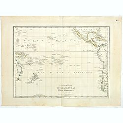
Carte reduite du Grand Océan partie Mériodionale. (Page XXV)
Detailed map of the Pacific giving good detail on Americas west coast. Including New Zealand and eastern part of Australia.Jean Baptiste Poirson (1760-1831) was a French ...
Place & Date: Paris, 1802
Selling price: $175
Sold in 2023
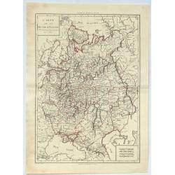
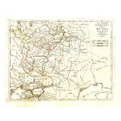
Carte de la Russie D'Europe.
A large 1802 map of North West part of Russia, including the Gulf of Finland, Belarus, Ukraine, Poland and Baltic countries. From the atlas “Géographie Mathématique,...
Place & Date: Paris, 1802
Selling price: $21
Sold in 2020
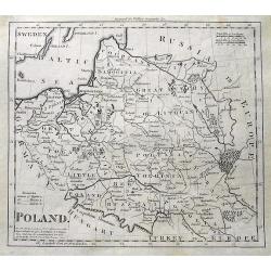
Poland.
An interesting map of Poland, Latvia and Lithuania, showing the various regions and cities. A distance scale in Polish Miles. Shaded lines show the areas moved to Russia ...
Place & Date: London, ca 1802
Selling price: $49
Sold in 2019

Le S. Brun et Blanc. Pl.81.
A very rare print of a humming bird from Histoire naturelle et générale des colibris, oiseaux-mouches, jacamars et promerops, by Jean Baptiste Audebert. Before his deat...
Place & Date: Paris, 1800-1802
Selling price: $180
Sold in 2011

Le S. Rouge-Dorée.
A very rare print of a humming bird from Histoire naturelle et générale des colibris, oiseaux-mouches, jacamars et promerops, by Jean Baptiste Audebert. Before his deat...
Place & Date: Paris, 1800-1802
Selling price: $200
Sold in 2011
![[Title page] Atlas de la République française ..](/uploads/cache/17247-250x250.jpg)
[Title page] Atlas de la République française ..
Title page from, Atlas de la République Française composé de 102 feuilles Indiquant les Départements, les arrondissements Communaux, Les Justices de Paix Actuelles, l...
Place & Date: Paris, 1802
Selling price: $35
Sold
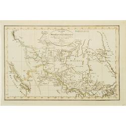
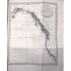
Charte von Mackenzie's Reisen von Montreal zu dem nördlichen Eis..
A detailed map north of Vancouver, Lake Michigan and New York. Showing the land discovered by Mackenzie during his travels to Montreal, Fort Chipewyan and North Regions i...
Place & Date: Weimar 1802
Selling price: $205
Sold
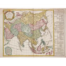
Asie divisee en ses principeaux Etats Empires & Royaumes.
Charles François Delamarche (1740-1817), Paris-based geographer and publisher, successor to Didier Robert de Vaugondy after his death in 1786.An attractive map of Asia.
Place & Date: Paris, 1802
Selling price: $220
Sold in 2014
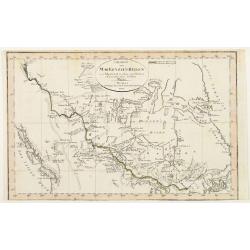
Charte von Mackenzie's Reisen von Montreal zu dem nördlichen Eis..
A detailed map north of Vancouver, Lake Michigan and New York. Showing the land discovered by Mackenzie during his travels to Montreal, Fort Chipewyan and North Regions i...
Place & Date: Weimar 1802
Selling price: $160
Sold
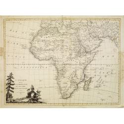
L'Afrique divisée en ses principaux Etats et Royaumes.
Uncommon Italian map of Africa. Interestinngly the map has several pencil annotations in the map.
Place & Date: Venise, 1802
Selling price: $450
Sold in 2008