Browse Listings
![[4 maps] Carte Hydro-Geo-Graphique des Indes Orientales en deça et au dela du Gange avec leur Archipel.. .](/uploads/cache/42474-250x250.jpg)
[4 maps] Carte Hydro-Geo-Graphique des Indes Orientales en deça et au dela du Gange avec leur Archipel.. .
A 4 sheet map south and east Asia, from Afghanistan in the west, across to China in the east, from the southern tip of the Indian peninsular and Ceylon (Sri Lanka) across...
Place & Date: Paris, ca. 1783
Selling price: $160
Sold in 2019
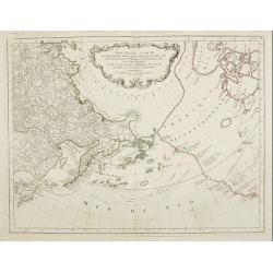
Carte de la Mer D'Azof et D'Une Partie de la Mer Noire.
Engraved map of the Crimean Peninsula with the Black Sea and the Sea of Azov in Russia. From the Atlas Volume of "Histoire physique, morale, civile et politique de ...
Place & Date: Paris, 1783
Selling price: $21
Sold in 2019
Les Indes Orientales et leur Archipel. . .
A good general map of Indonesia, extending from India to the Philippines and New Guinea.Decorated with a delightful title cartouche. Countries in hand color.From theAtlas...
Place & Date: Paris, ca 1783
Selling price: $95
Sold in 2020
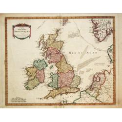
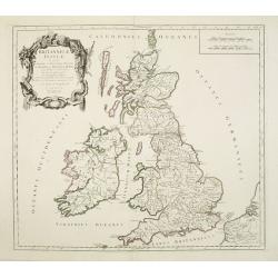
L'Ecosse avec ses Isles.
A decorative antique map of Scotland and islands, with two inlays of Craig Phadrich forested hill. It was published by Barbie and engraved by Doudan.Jean-Denis Barbié, k...
Place & Date: Paris, 1783
Selling price: $35
Sold in 2023
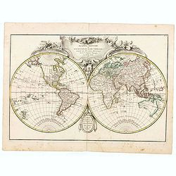
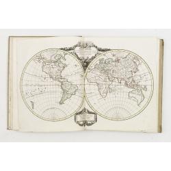
Mappemonde.
A nice small eighteenth century French double hemisphere world map. Points of interest are that Brazil, Australia and North America are all misshapen. No place names are ...
Place & Date: Paris, ca 1783
Selling price: $130
Sold in 2021
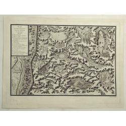
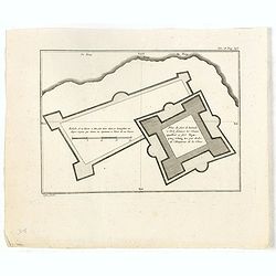
Plan et Coupe Horisontale du Labyrinte Souterrain de Koungour Renvoi.
A striking and highly detailed copper engraved chart showing Kungur and its fortifications. Kungur is a town in the southeast of Perm Krai, Russia, located in the Ural Mo...
Place & Date: Paris, 1783
Selling price: $13
Sold in 2021
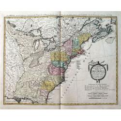
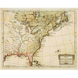
![ETATS-UNIS DE L'AMÉRIQUE divises en 13 Provinces... [early USA].](/uploads/cache/83012-250x250.jpg)
ETATS-UNIS DE L'AMÉRIQUE divises en 13 Provinces... [early USA].
Attractive map from Lamarche's Atlas Elementaire. Printed 3 years after the foundation of the New Republic. Lamarche was the successor to Vaugondy (often known as Delamar...
Place & Date: Paris, 1783
Selling price: $130
Sold in 2019
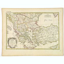
Turquie d'Europe et partie de celle d'Asie divisee. . .
An attractive map centered on the Aegean Sea, encompassing the whole Balkan Peninsula and part of Turkey.It includes also Crete and Cyprus. Decorated with a pretty title ...
Place & Date: Paris, ca 1783
Selling price: $27
Sold in 2021
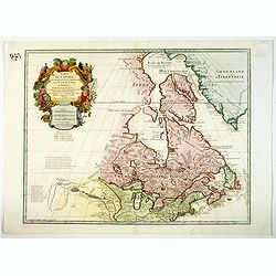
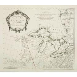
Carte du Canada qui comprend la Partie Septentrionale des Etats Unis d'Amerique. . .
First issued by Guillaume Delisle in 1703, this richly detailed map provides the most accurate rendering of the Great Lakes of the time, with the lakes fully enclosed and...
Place & Date: Paris, 1783
Selling price: $450
Sold in 2020
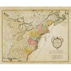
![AMERIQUE Septentrionale avec ses principales Divisions et leurs Capitales. [Mer de l'Ouest].](/uploads/cache/83552-250x250.jpg)
AMERIQUE Septentrionale avec ses principales Divisions et leurs Capitales. [Mer de l'Ouest].
An outlined colored map of north America , showing the Baye d'Hudson and the mythical 'Mer de l'Ouest'. With the names of cities, provinces and much more. With a numbered...
Place & Date: Paris, 1783
Selling price: $120
Sold in 2020
Parte del Nord del America Settentrionale ad uso della storia filosofica e politica degli Stabilimenti e del Commercio degli Europei nelle due Indie.
Uncommon map of the eastern part of North America. Drawn by R. Bonne for an Italian version of Abbé Raynal's Histoire philosophique et politique".
Place & Date: 1783
Selling price: $90
Sold in 2020
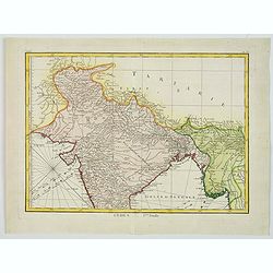
Indes. Iere. Feuille.
An attractive map of the northern part of India, extending northwards to Pakistan and Afghanistan, and it includes Bangladesh in the East. Boundaries outlined in hand col...
Place & Date: Paris, ca 1783
Selling price: $55
Sold in 2020
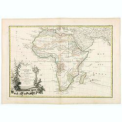
L'Afrique divisée en ses principaux Etats. . .
Attractive map of Africa, ornated with a decorative title cartouche showing luxuriant nature and native animals. Boundaries outlined in hand color.Prepared by Le Sieur Ja...
Place & Date: Paris, ca 1783
Selling price: $55
Sold in 2020
Mappe-Monde ou Description du Globe Terrestre..
World map, ornated with a large rococo title cartouche. Boundaries outlined in hand color.Prepared by Le Sieur Janvier, Jean denis [Robert], French geographer and cartogr...
Place & Date: Paris, ca 1783
Selling price: $167
Sold in 2020
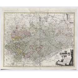
Der Sudliche Theil des Ober-Saechsischen Kreises.
A fine antique map of the southern part of Berlin & Upper-Saxony extending from Hildesheim and Küstrin in the north to Schweinfurth, Leitmeritz and Lauban in the sou...
Place & Date: Nuremberg, 1783
Selling price: $160
Sold in 2020
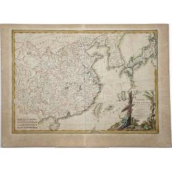
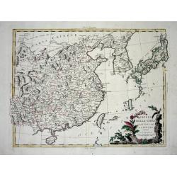
L'EMPIRE DE LA CHINE d'apres l'Atlas Chinois avec les isles du Japon.
An attractive map of eastern part of China, including Taiwan, Korea and Japan. With ornamental title cartouche. Boundaries outlined in hand color. From the 'Atlas moderne...
Place & Date: Paris, 1783
Selling price: $60
Sold in 2021
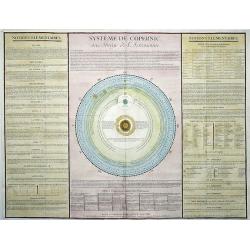
SYSTEME DE COPERNIC ou Abrege de l'Astronomie.
This is one of several decorative terrestrial and celestial engravings published in Paris, entitled 'System of Copernicus', presenting various astronomical and geographic...
Place & Date: Paris, 1783
Selling price: $32
Sold in 2021
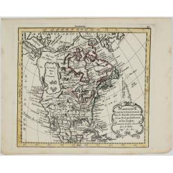
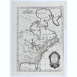
Amerique Septentrionale avec les Nouvelles Découvertes
The map of the North America in a quiet unusual shape.Comes from rarely seen Jean-Baptiste Nolin atlas “Atlas Général a l’usage des colleges et maisons d’educatio...
Place & Date: Paris, 1783
Selling price: $300
Sold in 2022
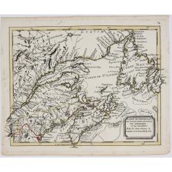
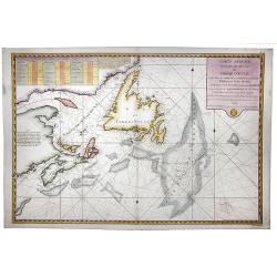
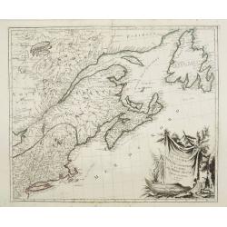
l'Isle de Terre Neuve le Canada et la Nouvelle Ecosse.
The map of North Eastern Canada, including Nova Scotia, Newfoundland and Labrador.Comes from rarely seen Jean-Baptiste Nolin atlas “Atlas Général a l’usage des coll...
Place & Date: Paris, 1783
Selling price: $250
Sold in 2022
Plan du fort de Zelande à l'île Formose, les chinois appellent ce fort Nganping-tching, tiré par ordre de l'empereur de la Chine.
Plan of the Dutch fort Zeeland on Taiwan and it direct environs. From "Lettres Édifiantes et Curieuses. . Missionaires de la Compagnie de Jesus [Jesuit Letters]&quo...
Place & Date: Paris, 1780-1783
Selling price: $55
Sold in 2022
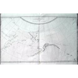
Chart of the N.W. Coast of America and N.E. Coast of Asia explored in the Years 1778 & 1779. . .
A scarce edition of Captain James Cook's discoveries in the Pacific Northwest, Alaska, and the Behring Strait. The map shows the northeast parts of Asia and the northwest...
Place & Date: London, ca 1784
Selling price: $105
Sold in 2019
Charte über die XIII. vereinigte Staaten von Nord-America, Entworfen duch F.L. Güssefeld. . .
A large map of the 13 United States, shortly after the American Revolutionary War or the American War of Independence, which ended in 1783. A very detailed map with many ...
Place & Date: Nuremberg, 1784
Selling price: $650
Sold in 2019
Carte Reduite des Bancs et de L'Ile de TERRE-NEUVE avec les Cotes du Golfe de St. Laurent et de l'Acadie.
A detailed chart showing the island of Nova Scotia, the St Laurence Gulf, and Acadie. With a fully colored key and numerous rhumb lines, published by the French Hydrograp...
Place & Date: Paris, 1784
Selling price: $600
Sold in 2020
A General Chart Exhibiting the Discoveries Made by Captn. James cook in This and his two Preceding Voyages. . .
A rare world map featuring the famous voyages and discoveries made by James Cook. The map was made by Lt. Henry Roberts who sailed as Masters Mate with Cook on board the ...
Place & Date: London, 1784
Selling price: $435
Sold in 2020
Empero Della China Giappone.
Fine map of China, Korea and Japan. Shows administrative boundaries, major cities, villages, rivers and mountains. Map from "Atlas Novissimo" printed in Venice ...
Place & Date: Venise, 1784
Selling price: $60
Sold in 2020
Britannicae Insulae in quibus Albion. . . Et Ivernia. . .
A large map of the British Isles. Ornated with a rococo title cartouche in the upper left corner.Venetian edition of Giles Didier Robert de Vaugondy's map based on Sanson...
Place & Date: Venice, 1776 - 1784
Selling price: $23
Sold in 2020
Germania Antiqua in quatuor magnos populos. . .
A fine map of ancient Germany, Poland and the Netherlands. Ornamental title cartouche in the lower left corner.Venetian edition of Giles Didier Robert De Vaugondy's map, ...
Place & Date: Venice, 1776 - 1784
Selling price: $17
Sold in 2021
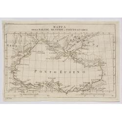
Mappa della Palude Meotide e Ponto Eusino.
A fine map of the Black and Azof Seas in the Crimea.
Place & Date: Venice, 1784
Selling price: $2
Sold in 2020
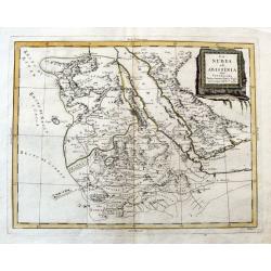
La Nubia ed Abissinia.
An Italian copper engraved map of the Red Sea and its coasts, including parts of Egypt and Arabia. Shows Mecca. With many place names, lakes, rivers, etc.
Place & Date: Venice, 1784
Selling price: $22
Sold in 2020
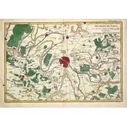
Environs de Paris.
Rigobert Bonne (1727-1795), French cartographer. His maps are found in a.o. Atlas Moderne (1762), Raynal's 'Histoire Philos. du Commerce des Indes' (1774) and 'Atlas Ency...
Place & Date: Paris, 1784
Selling price: $80
Sold
Carte réduite des Bancs et de l'Ile de Terre Neuve..
Detailed chart showing island Nova Scotia, the St Laurence Gulf, and Acadie.
Place & Date: Paris, 1784
Selling price: $200
Sold
Karte des oestliehe oder ehemahlige ENGLISCHEN AMERIKA nach den Besitzungen und ..
Rare 18th century German map of eastern United States. From: Johan Jacob Moser, Nord-America nach den Friedenschlussen vom Jahr 1783,1784.A first state.
Place & Date: Germany 1784
Selling price: $475
Sold
Charte uber die XIII vereingte Staaten von Nord-America..
Fine large map of the newly formed United States of America. The southern states are shown with their western boundaries on the Mississippi River, although the coloring s...
Place & Date: Nuremberg ca. 1784
Selling price: $1675
Sold
Carte du Royaume de Suede Norwege et Partie de Dannemarck.
Pierre Bourgoin, Paris-based engraver and publisher. Published in 1784 his uncommon ' Atlas Élémentaire de la Géographie'.A map depicting Scandinavia.
Place & Date: Paris, 1784
Selling price: $150
Sold
La repubblica d'Ollanda divisa nelle sue provincie di nuova projeezione.
Uncommon map of the Netherlands. Embellished with a nice title-cartouche. Engraved by G.V.Pasquali after G.Zuliani.From his Atlante Novissimo, illustrato ed accresciuto s...
Place & Date: Venice 1784
Selling price: $170
Sold
La provincie di Frisia, Groninga ed Over-Yssel con parte dell' Ollanda propria..
Uncommon map of the Northern part of the Netherlands. Embellished with a nice title-cartouche. Engraved by G.V.Pasquali after G.Zuliani.From his Atlante Novissimo, illust...
Place & Date: Venice 1784
Selling price: $130
Sold
La provincie di Zelanda, Utrecht, Gheldria e Brabante Ollandese con la parte meridionale dell'Ollanda..
Uncommon map of the Southern part of the Netherlands. Embellished with a nice title-cartouche. Engraved by G.V.Pasquali after G.Zuliani.From his Atlante Novissimo, illust...
Place & Date: Venice 1784
Selling price: $165
Sold

Biblical figures.
Christ raising Lazarus from the dead. Number 30 of the serial "History of the Old and new testament"
Place & Date: Antwerp 1784
Selling price: $50
Sold
Le Coste di Barbaria..
An engraved map of the Barbary Coast embellished with an colored pictorial title cartouche
Place & Date: Venice, 1784
Selling price: $100
Sold in 2017
La Tartaria Chinese.
With decorative title cartouche. Covering north eastern part of China, Korea and Hokkaido (here called Jeso-Gasima ).
Place & Date: Venice, 1784
Selling price: $400
Sold in 2010
Impero della China colle Isole del Giappone
Large copper-engraved map by Zatta, published in the monumental "Atlante Novissimo" in Venice. Shows Japan, Korea and China with Formosa in much detail. Handsom...
Place & Date: Venice 1784
Selling price: $280
Sold
Nouvel Atlas portatif destiné principalement..
Populair atlas with decorative title-page engraved by Groux and dated 1784. Four pages introduction and 3 fully engraved index pages. The condition of the maps throughout...
Place & Date: Paris 1784
Selling price: $2500
Sold
Carte des Isles Britanniques
Pierre Bourgoin, Paris-based engraver and publisher. Published in 1784 his uncommon ' Atlas Élémentaire de la Géographie'.Decorative map of the British Isles extending...
Place & Date: Paris, 1784
Selling price: $130
Sold in 2011
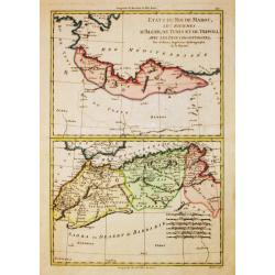
Etats du Roi de Maroc, Les Royaumes d' Alger, de Tunis et de Tripoli, avec les Pays circumvoisins.
Rigobert Bonne (1727-1795), French cartographer. His maps are found in a.o. Atlas Moderne (1762), Raynal's Histoire Philos. du Commerce des Indes (1774) and Atlas Encyclo...
Place & Date: Paris, 1784
Selling price: $50
Sold in 2016
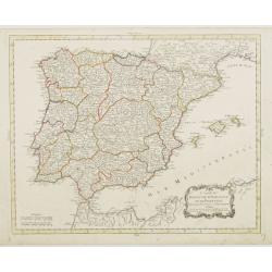
Carte du Royaume d' Espagne et de Portugal.
Detailed map of Spain, Portugal and Baleares islands. Showing also southwestern part of France and north Africa.Published in 1784 in his uncommon "Atlas Élémentair...
Place & Date: Paris, 1784
Selling price: $60
Sold in 2008
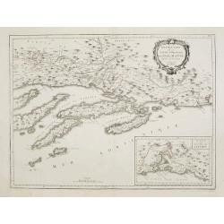
Nouvelle Carte de la Partie Occidentale de Dalmatie, dressee sur les lieux.
Finely and crisply engraved map depicting part of the Dalmatian coastline and its islands between Zadar and Omis, south of Split.In the lower right corner the island Vis,...
Place & Date: Venice, 1776 - 1784
Selling price: $450
Sold in 2010
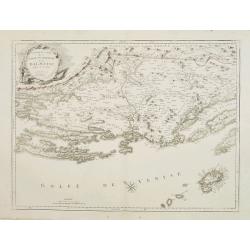
Nouvelle Carte de la Partie Orientale de Dalmatie, dressée sur les lieux.
Finely and crisply engraved map depicting the southern part of the Dalmatian coastline and its islands.Encompassing the area from the southern half of Brac island to the ...
Place & Date: Venice, 1776 - 1784
Selling price: $250
Sold
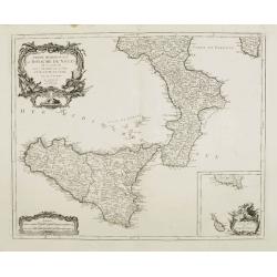
Partie Méridionale du Royaume de Naples où se trouvent la Calabre et l'Isle et Royaume de Sicile.
Finely and crisply engraved map of southern Italy, depicting Sicily and the region Calabria with remarkable topographical detail.Ornated with a large title cartouche and ...
Place & Date: Venice, 1776 - 1784
Selling price: $200
Sold in 2015
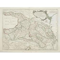
Carte de la Géorgie et des pays situés entre la Mer Noire et la Mer Caspienne..
Finely and crisply engraved map depicting the area comprehended between the Black Sea and the Caspian Sea.With ornamental title cartouche and noteworthy topographical det...
Place & Date: Venice, 1776 - 1784
Selling price: $500
Sold
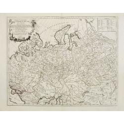
Partie Occidentale de l\'Empire de Russie en Asie..
Finely and crisply engraved map of the north-western part of Russia, with noteworthy topographical detail.Ornamental title cartouche in the upper left corner surrounded w...
Place & Date: Venice, 1776 - 1784
Selling price: $290
Sold in 2009
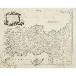
Asia Minor in suas partes seu provincias divisa.
Detailed map of Asia Minor and contiguous Islands and the Black Sea region, including Cyprus.With fine rococo title cartouche in the upper left corner.The map was prepare...
Place & Date: Venice, 1776 - 1784
Selling price: $250
Sold
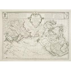
Carte des nouvelles decouvertes au Nord de la Mer du Sud.
Although concentrating on the northern Pacific, this map show all of North America and Mexico.A very interesting Northwest Passage is shown.While the Russian coastline is...
Place & Date: Venice, 1776 - 1784
Selling price: $1200
Sold in 2008
Partie Occidentale du Canada et Septentrionale de la Louisiane..
Fine copper engraved map of the Great Lakes region after d'Anville's, to whom Santini gives credit in the cartouche.The map extends from the upper Mississippi River valle...
Place & Date: Venice, 1776 - 1784
Selling price: $325
Sold in 2022
Partie Orientale du Canada avec la Nouvelle Angleterre..
Fine map of the extremities of Canada after d'Anville's, to whom Santini gives credit in the cartouche.The map extends from New York northwards to include Lake Mistassini...
Place & Date: Venice, 1776 - 1784
Selling price: $1150
Sold
Nouvelle Carte des Decouvertes Faites par des Vaisseaux Russes aux Cotes Inconnues del' Amerique Septentrionale avec les Pais Adiancents..
Santini's version of Gerhard Muller's landmark map of 1754 showing the discoveries of Captains Bering and Tschirikow.Muller originally published his map in response to Jo...
Place & Date: Venice, 1784
Selling price: $1050
Sold in 2011
Gouvernements de Flandre Françoise, d'Artois, de Picardie..
Detailed map encompassing northwestern part of France, with the Channel and tip of southern England.Venetian edition of the map by Bellin, to whom Santini gives credit in...
Place & Date: Venice, 1776 - 1784
Selling price: $150
Sold in 2008
Carte des Isles de Majorque, Minorque, et Yvice..
Decorative map representing the Balearic islands, Minorca, Majorca, Ibiza. With 2 insets and an ornamental title cartouche.Venetian edition of the map by Bellin, to whom ...
Place & Date: Venice, 1776 - 1784
Selling price: $750
Sold in 2008
Le Territoire de Verone dressé sur les meilleures Cartes.
Finely and crisply engraved map centered on Verona. Showing lake Garda and Mantua.Large decorative title cartouche in the lower left corner. Relief shown pictorially.
Place & Date: Venice, 1776 - 1784
Selling price: $100
Sold in 2018
Partie Septentrionale de l'Etat de l'Eglise, contenant les légations de Ferrare, de Bologne, et de Romagne..
Finely and crisply engraved map depicting Romagna and part of Emilia with remarkable topographical detail. Including Remini, Ravenna, Bologna, etc.2 inset maps respective...
Place & Date: Venice, 1776 - 1784
Selling price: $450
Sold
Partie de milieu de l'Etat de l'Eglise contenant la légation d'Urbin, la Marche, l'Ombrie..
Finely and crisply engraved map illustrating the regions Umbria and Marche with remarkable topographical detail.Centered on Perugia. Title on top. Relief shown pictoriall...
Place & Date: Venice, 1776 - 1784
Selling price: $360
Sold
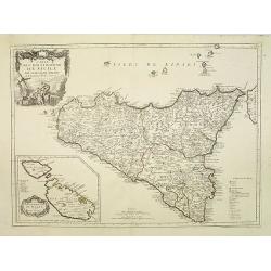
Carte de l\'Isle et Royaume de Sicile. . .
Finely and crisply engraved map of Sicily and the Lipari Islands, with remarkable topographical detail.Venetian edition of de l\'Isle\'s map, from \"Atlas Universel\...
Place & Date: Venice, 1776 - 1784
Selling price: $550
Sold in 2009
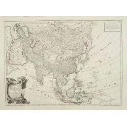
L\'Asie divisée en ses principaux Etats..
Finely and crisply engraved map of Asia, decorated with an ornamental title cartouche in the lower left corner. Noteworthy topographical detail is shown. Shows New Guinea...
Place & Date: Venice, 1776 - 1784
Selling price: $550
Sold in 2009
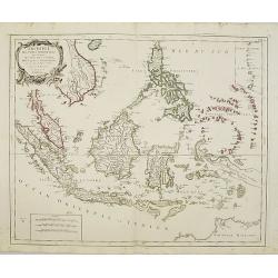
Archipel des Indes Orientales, qui comprend les Isles de la Sonde, Moluques et Philippines, tirées des cartes du Neptune Oriental..
Finely and crisply engraved map of the Malay Archipelago, including the Philippines south to the northern coast of Australia. Decorated with an ornamental title cartouche...
Place & Date: Venice, 1776 - 1784
Selling price: $650
Sold
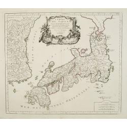
L'Empire Du Japon Divise En Sept Principales Parties..
Santini's Italian published edition of Giles Didier Robert De Vaugondy's map of Japan first appeared in 1778 in the "Atlas Universel".In 1784 Santini sold the p...
Place & Date: Venice, 1776 - 1784
Selling price: $600
Sold in 2008
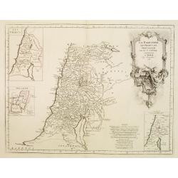
La Palestine, les Tribus, et Jerusalem par le Sr. d'Anville.
Map of Palestine on both sides of the Jordan, the shore line running from Sidon to Rhinocorura (El-Harish).The Jordan river between teh Lake of Tiberias and the Dead Sea ...
Place & Date: Venice, 1776 - 1784
Selling price: $130
Sold in 2023
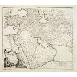
Etats du Grand-Seigneur en Asie, Empire de Perse, Pays des Usbecs, Arabie et Egypte.
Detailed map of the region bounded by the Black Sea, Georgia, the Caspian, Uzbekistan, The Indian Ocean, Saudi Arabia (here called "Arabie Heureuse"), Egypt and...
Place & Date: Venice, 1776 - 1784
Selling price: $400
Sold in 2008
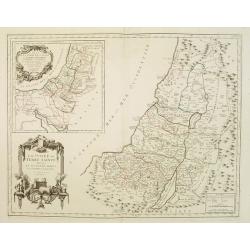
La Judée ou Terre Sainte divisée en ses douze Tribus..
A finely engraved and uncommon map depicting the division of the Holy Land into twelve tribes. In upper left hand corner inset map of land of Canaan.Venetian edition of G...
Place & Date: Venice, 1776 - 1784
Selling price: $350
Sold in 2008
Germania Antiqua in quatuor magnos populos..
A fine map of ancient Germany, Poland and the Netherlands. Ornamental title cartouche in the lower left corner.Venetian edition of Giles Didier Robert De Vaugondy's map, ...
Place & Date: Venice, 1776 - 1784
Selling price: $50
Sold in 2008
Britannicae Insulae in quibus Albion.. Et Ivernia..
Map of the British Isles. Ornated with a rococo title cartouche in the upper left corner.Venetian edition of Giles Didier Robert De Vaugondy's map based on Sanson. From &...
Place & Date: Venice, 1776 - 1784
Selling price: $200
Sold in 2008
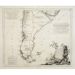
Carte du Chili Méridional, du Rio de la Plata, des Patagons, et du Détroit de Magellan. . .
Finely and crisply engraved map representing the southern tip of South America. It extends northwards as far as the river de la Plata estuary.Venetian edition of d\'Anvil...
Place & Date: Venice, 1776 - 1784
Selling price: $500
Sold in 2008
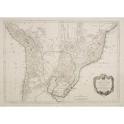
Carte qui représente la Partie Méridionale du Brésil et du Perou..
Finely and crisply engraved map representing the central part of South America, including part of Brazil, Chile and Peru as well as Uruguay and Paraguay.It covers the Atl...
Place & Date: Venice, 1776 - 1784
Selling price: $300
Sold in 2009
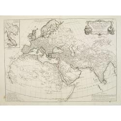
Orbis Veteribus Notus Auspiciis Serenissimi Principis..
Finely and crisply engraved map of Europe, Asia and Africa, prepared by d'Anville. With inset map of the Indochinese Peninsula in the upper left corner.Venetian edition o...
Place & Date: Venice, 1776 - 1784
Selling price: $250
Sold in 2008
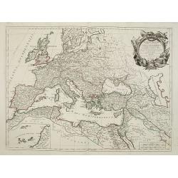
Romani Imperii occidentis .. Tabula Geographica..
Finely and crisply engraved map of the Roman Empire centered on Italy and Greece.Showing the Mediterranean basin together with its hinterland in Africa and Asia. Inset ma...
Place & Date: Venice, 1776 - 1784
Selling price: $150
Sold in 2009
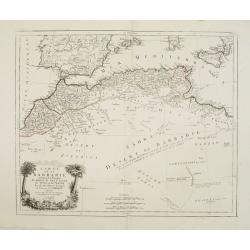
Carte de la Barbarie, contenant les Royaumes de Maroc, de Fez, d'Alger, de Tunis et de Tripoli..
Finely and crisply engraved map of North Africa from Morocco to Libya. At bottom left an decorative cartouche with trees, a lion and female figure.After the maps by d'Anv...
Place & Date: Venice, 1776 - 1784
Selling price: $250
Sold in 2014
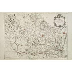
Carte du Padouan du dogado, et de la plus grande partie du vicentin. . .
Finely and crisply engraved map of Vicence, Padua and Venice region.Showing to the right the Lagune of Venice.Venetian edition of Giles Didier Robert De Vaugondy's map fr...
Place & Date: Venice, 1776 - 1784
Selling price: $300
Sold in 2015
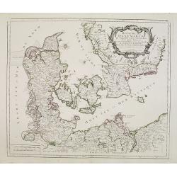
Royaume de Danemarck..Sélande, Laland.
Finely and crisply engraved map of Denmark.Venetian edition of Giles Didier Robert De Vaugondy's map from Atlas Universel printed in 1776-84.Ornamental title cartouche in...
Place & Date: Venice, 1776 - 1784
Selling price: $100
Sold in 2016
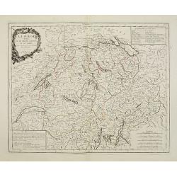
La Suisse divisée en ses treize cantons et ses alliés..
Finely and crisply engraved map of Switzerland from Geneva to Lake Constance.Venetian edition of Giles Didier Robert De Vaugondy\'s map from Atlas Universel printed in 17...
Place & Date: Venice, 1778 - 1784
Selling price: $120
Sold in 2009
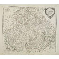
Le Royaume de Boheme.. Moravie et Lusace.
Finely and crisply engraved map of Czechoslovakia, including Pilsen.Venetian edition of Giles Didier Robert De Vaugondy's map from Atlas Universel printed in 1776-84.Orna...
Place & Date: Venice, 1777 - 1784
Selling price: $60
Sold in 2023
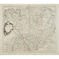
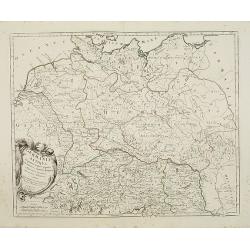
Cercle de Westphalie divisé en tous ses Etats et Souverainetés.
Finely and crisply engraved map of central Germany, including the river Rhine from Deventer till Bonn, with Dusseldorf. In upper left , inset of the area of Emden until O...
Place & Date: Venice, 1776 - 1784
Selling price: $50
Sold in 2016
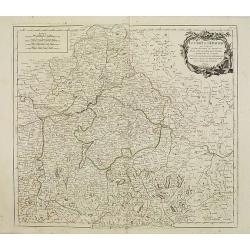
Le cercle De Baviere.. et la prevoté de Berchtolsgaden.
Finely and crisply engraved map centered on Regensburg, including some great skiing resort areas of Austria and part of Germany, centered on Passau, Ingollstat, Salzburg....
Place & Date: Venice, 1776 - 1784
Selling price: $25
Sold in 2021