Browse Listings
Carte du Paraguay et partie des Pays adjacants.
Jean Lattré, Paris-based engraver and publisher. Worked with Robert de Vaugondy, J. Janvier and R. Bonne. " Atlas Monderne', 1771, 1783 , 1793. Rigobert Bonne (1727...
Date: Paris, 1783
Selling price: ????
Please login to see price!
Sold

Atlas Moderne ou collection des cartes sur toutes les parties du Globe Terrestre..
Jean Lattré, Paris-based engraver and publisher. Worked with Robert de Vaugondy, J. Janvier and R. Bonne. " Atlas Monderne', 1771, 1783 , 1793. A decorative frontis...
Date: Paris, 1783
Selling price: ????
Please login to see price!
Sold
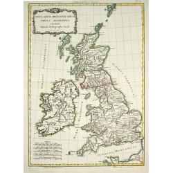
Insularum Britannicarum Tabula Geographica.
Jean Lattré, Paris-based engraver and publisher. Worked with Robert de Vaugondy, J. Janvier and R. Bonne. " Atlas Monderne', 1771, 1783 , 1793. Rigobert Bonne (1727...
Date: Paris, 1783
Selling price: ????
Please login to see price!
Sold in 2011
![Le Braque de Bengale [Pl. 23]](/uploads/cache/21828-250x250.jpg)
Le Braque de Bengale [Pl. 23]
A charming plate from "Histoire Naturelle, Générale et Particulière," Georges Louis Marie Leclerc, comte de Buffon's magnum opus and "the most celebrate...
Date: Paris: Imprimerie Royale, 1749-1783
Selling price: ????
Please login to see price!
Sold in 2010

Le Mâtin.
A charming plate from "Histoire Naturelle, Générale et Particulière," Georges Louis Marie Leclerc, comte de Buffon's magnum opus and "the most celebrate...
Date: Paris, Imprimerie Royale, 1749-1783
Selling price: ????
Please login to see price!
Sold in 2022

Le Basset à jambes Torses.
A charming plate from "Histoire Naturelle, Générale et Particulière," Georges Louis Marie Leclerc, comte de Buffon's magnum opus and "the most celebrate...
Date: Paris: Imprimerie Royale, 1749-1783
Selling price: ????
Please login to see price!
Sold in 2023

Le Pyrame.
A charming plate from "Histoire Naturelle, Générale et Particulière," Georges Louis Marie Leclerc, comte de Buffon's magnum opus and "the most celebrate...
Date: Paris: Imprimerie Royale, 1749-1783
Selling price: ????
Please login to see price!
Sold in 2023

Le Petit Barbet.
A charming plate from "Histoire Naturelle, Générale et Particulière," Georges Louis Marie Leclerc, comte de Buffon's magnum opus and "the most celebrate...
Date: Paris: Imprimerie Royale, 1749-1783
Selling price: ????
Please login to see price!
Sold in 2022
![Le Grand Barbet [Pl. 26]](/uploads/cache/21915-250x250.jpg)
Le Grand Barbet [Pl. 26]
A charming plate from "Histoire Naturelle, Générale et Particulière," Georges Louis Marie Leclerc, comte de Buffon's magnum opus and "the most celebrate...
Date: Paris: Imprimerie Royale, 1749-1783
Selling price: ????
Please login to see price!
Sold in 2022

Le Chien D'Islande.
A charming plate from "Histoire Naturelle, Générale et Particulière," Georges Louis Marie Leclerc, comte de Buffon's magnum opus and "the most celebrate...
Date: Paris: Imprimerie Royale, 1749-1783
Selling price: ????
Please login to see price!
Sold

Le Dogue de Forte Race.
A charming plate from "Histoire Naturelle, Générale et Particulière," Georges Louis Marie Leclerc, comte de Buffon's magnum opus and "the most celebrate...
Date: Paris: Imprimerie Royale, 1749-1783
Selling price: ????
Please login to see price!
Sold in 2022
![Le Chien Courant [Pl. 21]](/uploads/cache/21919-250x250.jpg)
Le Chien Courant [Pl. 21]
A charming plate from "Histoire Naturelle, Générale et Particulière," Georges Louis Marie Leclerc, comte de Buffon's magnum opus and "the most celebrate...
Date: Paris: Imprimerie Royale, 1749-1783
Selling price: ????
Please login to see price!
Sold in 2022
![L'Axis Femelle [Pl. 151]](/uploads/cache/21921-250x250.jpg)
L'Axis Femelle [Pl. 151]
A charming plate from "Histoire Naturelle, Générale et Particulière," Georges Louis Marie Leclerc, comte de Buffon's magnum opus and "the most celebrate...
Date: Paris: Imprimerie Royale, 1749-1783
Selling price: ????
Please login to see price!
Sold
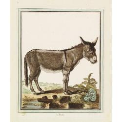
L'Âne.
A charming plate from "Histoire Naturelle, Générale et Particulière," Georges Louis Marie Leclerc, comte de Buffon's magnum opus and "the most celebrate...
Date: Paris: Imprimerie Royale, 1749-1783
Selling price: ????
Please login to see price!
Sold
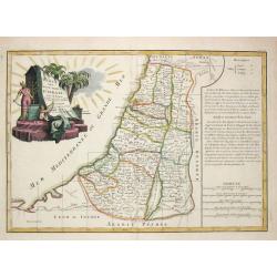
Carte des douzes Tribus d' Israel.
Jean Lattré, Paris-based engraver and publisher. Worked with Robert de Vaugondy, J. Janvier and R. Bonne. " Atlas Monderne', 1771, 1783 , 1793. Rigobert Bonne (1727...
Date: Paris, 1783
Selling price: ????
Please login to see price!
Sold
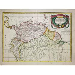
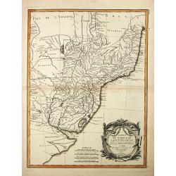
Carte de la Terre Ferme, dela Guyane et du Pays des Amazones.
Jean Lattré, Paris-based engraver and publisher. Worked with Robert de Vaugondy, J. Janvier and R. Bonne. " Atlas Monderne', 1771, 1783 , 1793. Rigobert Bonne (1727...
Date: Paris, 1783
Selling price: ????
Please login to see price!
Sold
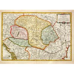
Le Royaume de Hongrie Divisé en Haute et Basse Hongrie Transylvanie Esclavonie et Croatie.
Jean Lattré, Paris-based engraver and publisher. Worked with Robert de Vaugondy, J. Janvier and R. Bonne. " Atlas Monderne', 1771, 1783 , 1793. Jean Janvier, French...
Date: Paris, 1783
Selling price: ????
Please login to see price!
Sold in 2010
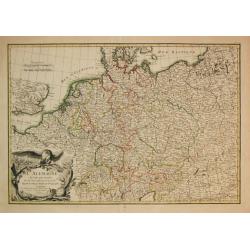
L\' Alemagne Divisée par Cercles.
Jean Lattré, Paris-based engraver and publisher. Worked with Robert de Vaugondy, J. Janvier and R. Bonne. " Atlas Monderne', 1771, 1783 , 1793. Giovanni Antonio Riz...
Date: Paris, 1783
Selling price: ????
Please login to see price!
Sold in 2009
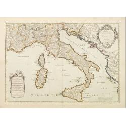
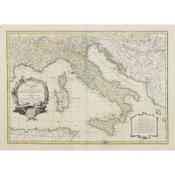
L'Italie.
Un uncommon re-issue by Desnos of this fine map of Italy, including Sardinia and Corsica. Prepared by Sanson and originally published by Jaillot.The map is colored in out...
Date: Paris 1783
Selling price: ????
Please login to see price!
Sold
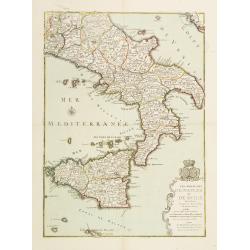
Les Royaumes de Naples et de Sicile.
Un uncommon re-issue by Desnos of this fine map of Italy, including Sardinia and Corsica. Prepared by Sanson and originally published by Jaillot.The map is colored in out...
Date: Paris 1783
Selling price: ????
Please login to see price!
Sold
Partie de L'Amerique Septentrionale qui comprend le Canada, la Louisiana, le Labrador, le Groenland, les Etats-Unis et la Floride
Jean Lattré, Paris-based engraver and publisher. Worked with Robert de Vaugondy, J. Janvier and R. Bonne. " Atlas Monderne', 1771, 1783 , 1793. Rigobert Bonne (1727...
Date: Paris, 1783
Selling price: ????
Please login to see price!
Sold
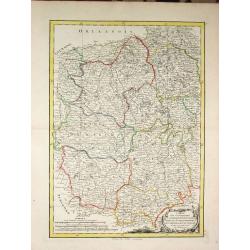
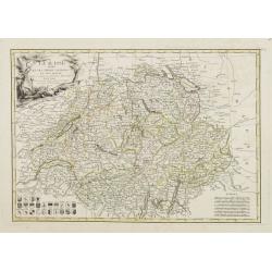
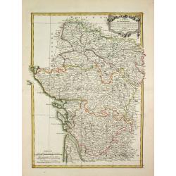
Carte des Gouvernements du Berri, du Nivernois, de la Marche, du Bourbonnois, du Limosin et de l\' Auvergne.
Jean Lattré, Paris-based engraver and publisher. Worked with Robert de Vaugondy, J. Janvier and R. Bonne. " Atlas Monderne', 1771, 1783 , 1793. Rigobert Bonne (1727...
Date: Paris, 1783
Selling price: ????
Please login to see price!
Sold in 2014
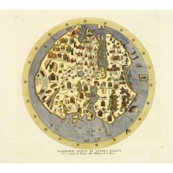
Planisfero Antico di Andrea Bianco Che si conserva in Venezia nella Biblioteca di S. Marco.
Fine and decorative presentation of Andrea Bianco's circular world map of 1436, kept in the library of the Vatican in Rome. Copper engraved version (1783) from the first ...
Date: Venice, Presso l'autore, 1783
Selling price: ????
Please login to see price!
Sold in 2011
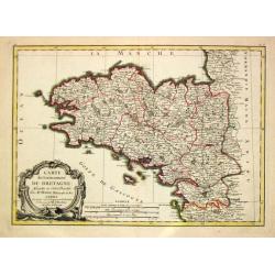
Carte du Gouvernement de Bretagne.
Jean Lattré, Paris-based engraver and publisher. Worked with Robert de Vaugondy, J. Janvier and R. Bonne. " Atlas Monderne', 1771, 1783 , 1793. Rigobert Bonne (1727...
Date: Paris, 1783
Selling price: ????
Please login to see price!
Sold
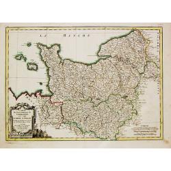
Carte du Gouvernement de Normandie avec celui du Maine et Perche.
Jean Lattré, Paris-based engraver and publisher. Worked with Robert de Vaugondy, J. Janvier and R. Bonne. "Atlas Monderne", 1771, 1783 , 1793. Rigobert Bonne (...
Date: Paris, 1783
Selling price: ????
Please login to see price!
Sold in 2018
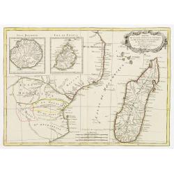
Partie de la Cote Orientale d' Afrique avec l' Isle de Madagascar et les Cartes particulières des Isles de France et de Bourbon..
A map of the south eastern coast of Africa and the island of Madagascar, comprehending 2 insets of the island of Bourbon (today Reunion) and Mauritius.From the Atlas mode...
Date: Paris ca 1783
Selling price: ????
Please login to see price!
Sold
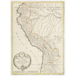
Carte du Perou ou se trouvent les Audiences de Quito, Lima et la Plata..
Attractive map centered on Peru, covering the northern half of the South American Pacific coast, from Ecuador to northern Chili.Boundaries outlined in hand color. Large o...
Date: Paris ca 1783
Selling price: ????
Please login to see price!
Sold
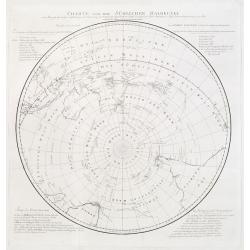
Charte von der Südlichen Halbkugel..
German edition of Cook's hemispherical map of the Antarctic. Engraved by F.G. Berger. From J.R. Forster's "Bemerkungen über Gegenständeder physischen Erdbeschreibu...
Date: Berlin 1783
Selling price: ????
Please login to see price!
Sold
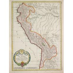
Carte Carte du Perou ou se trouvent les Audiences de Quito, Lima et la Plata.
Jean Lattré, Paris-based engraver and publisher. Worked with Robert de Vaugondy, J. Janvier and R. Bonne. " Atlas Monderne', 1771, 1783 , 1793. Rigobert Bonne (1727...
Date: Paris, 1783
Selling price: ????
Please login to see price!
Sold in 2019
Imperii Romani Pars Occidentalis Superior / Inferior / Pars Orientalis superior / Inferior.
Jean Lattré, Paris-based engraver and publisher. Worked with Robert de Vaugondy, J. Janvier and R. Bonne. " Atlas Monderne', 1771, 1783 , 1793. Rigobert Bonne (1727...
Date: Paris, 1783
Selling price: ????
Please login to see price!
Sold
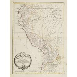
Carte du Perou ou se trouvent les Audiences de Quito, Lima et la Plata..
Attractive map centered on Peru, covering the northern half of the South American Pacific coast, from Ecuador to northern Chili.Boundaries outlined in hand color. Large o...
Date: Paris, ca 1783
Selling price: ????
Please login to see price!
Sold in 2012
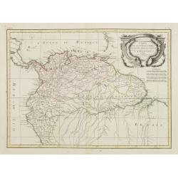
Carte de la Terre Ferme, de la Guyane et du Pays des Amazones..
Attractive map centered on the Amazon drainage basin, covering the northern part of South America. Ornated with a rococo title cartouche. Boundaries outlined in hand colo...
Date: Paris, ca 1783
Selling price: ????
Please login to see price!
Sold
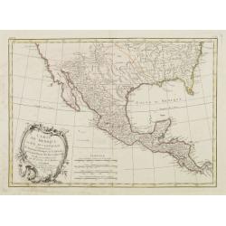
Carte Du Mexique ou de la Nlle. Espagne Contenant aussi le Nouveau Mexique, la Californie, avec une Partie des Pays adjecents . . . 1771
Attractive map centered on Mexico, covering the whole Central America and the southern part of the United States.Ornated with a rococo title cartouche. Includes excellent...
Date: Paris, ca 1783
Selling price: ????
Please login to see price!
Sold in 2020
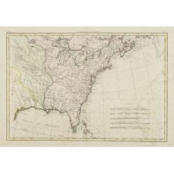
Canada IIe. Feuille.
Attractive map covering the eastern half of the United States, from the gulf of Mexico as far as Canada. Boundaries outlined in hand color.From theAtlas moderne ou collec...
Date: Paris, ca 1783
Selling price: ????
Please login to see price!
Sold in 2013
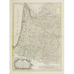
Carte du Gouvernement de Guienne et Gascogne.. Navarre..
Attractive map of the south western part of France delimited by the Garonneoutfall, the town of Toulouse and the Pyrenees.Decorated with a rococo title cartouche. Boundar...
Date: Paris, ca 1783
Selling price: ????
Please login to see price!
Sold
La Suisse divisée En Ses Treize Cantons Et Ses Alliés..
Attractive map of Switzerland, ornated with a rococo title cartouche. 24 coats of arms in the lower left corner. Boundaries outlined in hand color.From theAtlas moderne o...
Date: Paris, ca 1783
Selling price: ????
Please login to see price!
Sold
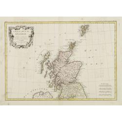
Carte Du Royame D'Ecosse..
Attractive map of Scotland, including the Shetland Islands. Decorated with a rococo title cartouche. Boundaries outlined in hand color.From theAtlas moderne ou collection...
Date: Paris, ca 1783
Selling price: ????
Please login to see price!
Sold
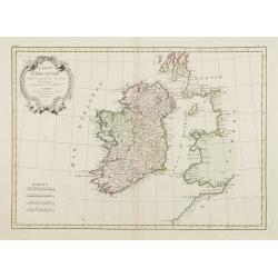
Carte D'Irlande..
Attractive map of Ireland, ornated with a rococo title cartouche. Boundaries outlined in hand color.From theAtlas moderne ou collection de cartes sur toutes les parties d...
Date: Paris, ca 1783
Selling price: ????
Please login to see price!
Sold
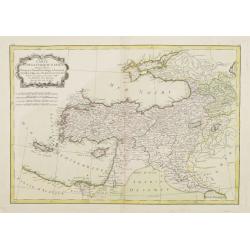
Carte de la Turquie d'Asie..
Attractive map of the Near East centered on Turkey, ornated with a rococo title cartouche. A curious shape for Cyprus. Boundaries outlined in hand color.From theAtlas mod...
Date: Paris ca 1783
Selling price: ????
Please login to see price!
Sold
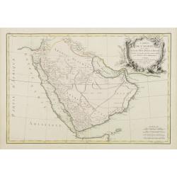
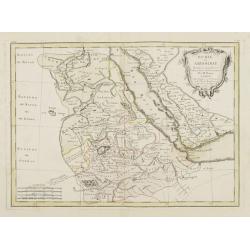
Carte de l'Arabie qui se divise en Arabie Petrée, Deserte et Heureuse..
Attractive map of the Arabian peninsula, ornated with a rococo title cartouche. Boundaries outlined in hand color.From theAtlas moderne ou collection de cartes sur toutes...
Date: Paris, ca 1783
Selling price: ????
Please login to see price!
Sold in 2009
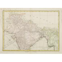
Indes. Iere. Feuille.
Attractive map of the northern part of India, extending northwards to Pakistan and Afghanistan. Including Bangladesh in the East. Boundaries outlined in hand color.From t...
Date: Paris, ca 1783
Selling price: ????
Please login to see price!
Sold in 2010
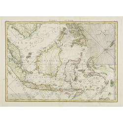
Indes IVe. Feuille.
Attractive map of the East Indies, centered on Borneo. Boundaries outlined in hand color.From theAtlas moderne ou collection de cartes sur toutes les parties du globe ter...
Date: Paris, ca 1783
Selling price: ????
Please login to see price!
Sold in 2012
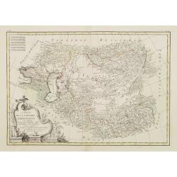
Carte de la Tartarie Indépendante qui comprend le Pays des Calmuks, celui des Usbeks, et le Turkestan..
Attractive map covering the area between the Caspian Sea and China. In lower right part Tibet ou Budian. Ornated with a decorative title cartouche. Boundaries outlined in...
Date: Paris, ca 1783
Selling price: ????
Please login to see price!
Sold in 2008
Nubie et Abissinie..
Attractive map showing today Ethiopia and Eritrea. Ornated with a decorative title cartouche. Boundaries outlined in hand color.From theAtlas moderne ou collection de car...
Date: Paris, ca 1783
Selling price: ????
Please login to see price!
Sold
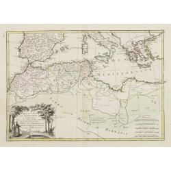
Carte des Côtes de Barbarie ou les Royaumes de Maroc.. Circonvoisins..
Attractive map of North Africa, ornated with a decorative title cartouche. Boundaries outlined in hand color.From theAtlas moderne ou collection de cartes sur toutes les ...
Date: Paris, ca 1783
Selling price: ????
Please login to see price!
Sold in 2011
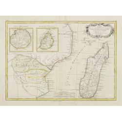
Partie de la Cote Orientale D'Afrique avec l'Isle de Madagascar.. Isles de France et de Bourbon..
Attractive map of part of South Africa, including Madagascar and 2 insets with the Reunion and Mauritius Islands.Ornated with a decorative title cartouche. Boundaries out...
Date: Paris, ca 1783
Selling price: ????
Please login to see price!
Sold
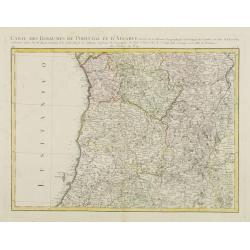
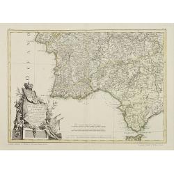
Carte des Royaumes de Portugal et D\'Algarve..
Map of the northern part of Portugal prepared by Giovanni Antonio Bartolomeo Rizzi Zannoni, one of the leading cartographers of the late 18th century, as well as being an...
Date: Paris, ca 1783
Selling price: ????
Please login to see price!
Sold in 2010
Mapa dos Reynos de Portugal e Algarve. . .
Map of the southern part of Portugal, including part of Spain and Gibraltar. The large decorative title cartouche presents the coat of arms surmounted by a crown, a repre...
Date: Paris, ca 1783
Selling price: ????
Please login to see price!
Sold in 2020

L'Allemagne Divisée par Cercles..
General map of central Europe, centered on Germany but including Poland, Belgium, the Netherlands, Switzerland, Austria and part of eastern Europe.Ornated with a decorati...
Date: Paris, ca 1783
Selling price: ????
Please login to see price!
Sold in 2016
![[No title] Map of the Netherlands, Belgium and the north western part of Germany.](/uploads/cache/24262-250x250.jpg)
[No title] Map of the Netherlands, Belgium and the north western part of Germany.
Attractive map centered on the Netherlands, encompassing the area between Calais, Gottingen up to Denmark.Ornated with a cartouche containing a dedication to "S.E. M...
Date: Paris, ca 1783
Selling price: ????
Please login to see price!
Sold
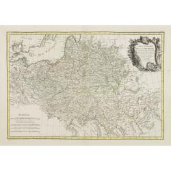
Carte Generale de la Pologne avec tous les Etats qui en dependent..
Attractive map of Poland, ornated with a rococo title cartouche. Boundaries outlined in hand color.Prepared by Giovanni Antonio Bartolomeo Rizzi Zannoni, one of the leadi...
Date: Paris ca 1783
Selling price: ????
Please login to see price!
Sold
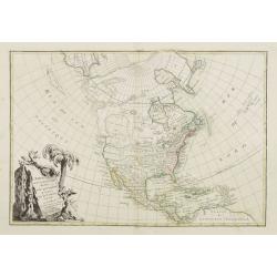
L' Amerique Septentrionale divisée en ses principaux Etats... (Sea of the West)
Attractive map of North and Central America, ornated with a decorative title cartouche. Boundaries outlined in hand color.Showing the explorations of Verenrye with regard...
Date: Paris, 1771-1783
Selling price: ????
Please login to see price!
Sold in 2017
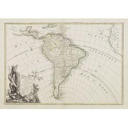
L' Amerique Meridionale divisée en ses principaux Etats..
Attractive map of South America, ornated with a decorative title cartouche. Boundaries outlined in hand color.Prepared by Le Sieur Janvier, Jean denis [Robert], French ge...
Date: Paris, ca 1783
Selling price: ????
Please login to see price!
Sold in 2012
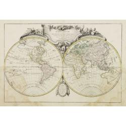
Mappe-Monde ou Description du Globe Terrestre..
World map, ornated with a large rococo title cartouche. Boundaries outlined in hand color.Prepared by Le Sieur Janvier, Jean denis [Robert], French geographer and cartogr...
Date: Paris, ca 1783
Selling price: ????
Please login to see price!
Sold
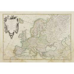
L'Europe divisée en ses principaux Etats..
Attractive map of Europe, ornated with a decorative title cartouche. Boundaries outlined in hand color.Prepared by Le Sieur Janvier, Jean denis [Robert], French geographe...
Date: Paris, ca 1783
Selling price: ????
Please login to see price!
Sold
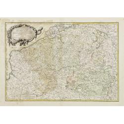
Partie Méridionale des Pays Bas, Comprenant les Provinces de Brabant, Gueldre, Lumbourg, Luxembourg..
Attractive map centered on Belgium, encompassing Luxembourg, part of France and the southern part of the Netherlands.ornated with a decorative title cartouche. Boundaries...
Date: Paris, ca 1783
Selling price: ????
Please login to see price!
Sold in 2008
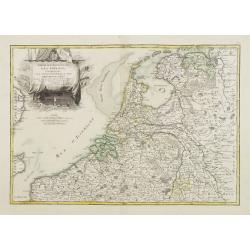
Partie Septentrionale des Pays Bas, Comprenant les Etats Généraux des Provinces Unies..
Very attractive map centered on the Netherlands. The title is included in the stern sail of a large Dutch vessel. Boundaries outlined in hand color.Prepared by Le Sieur J...
Date: Paris, ca 1783
Selling price: ????
Please login to see price!
Sold

Les Royaumes D'Espagne et de Portugal, divisés Par Grandes Provinces..
Attractive map of the Iberian Peninsula. Boundaries outlined in hand color.Ornated with a decorative title cartouche showing the coats of arms of Spain and Portugal.Prepa...
Date: Paris, ca 1783
Selling price: ????
Please login to see price!
Sold in 2023
L' Italie divisée en ses differents Etats Royaumes et republiques..
Attractive map of the Italian Peninsula, showing also Corsica and Malta. Boundaries outlined in hand color.Ornated with a decorative title cartouche presenting the symbol...
Date: Paris ca 1783
Selling price: ????
Please login to see price!
Sold
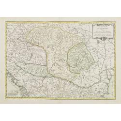
Le Royaume de Hongrie Divisé en Haute et Basse Hongrie..
Attractive map centered on Hungary, ornamented with a decorative title cartouche. Boundaries outlined in hand color.Prepared by Le Sieur Janvier, Jean denis [Robert], Fre...
Date: Paris, ca 1783
Selling price: ????
Please login to see price!
Sold in 2012
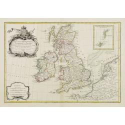
Les isles Britanniques comprenant les Royaumes d\'Angleterre d\'Ecosse et d\'Irlande..
Attractive map of the British Isles, ornated with a decorative title cartouche and a scale cartouche.With inset map including the Orcade and Shetland Islands. Boundaries ...
Date: Paris, ca 1783
Selling price: ????
Please login to see price!
Sold in 2008
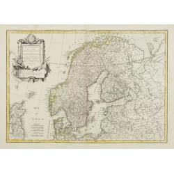
Les Couronnes du Nord comprenant les Royaumes de Suede Danemarck et Norwege..
Attractive map of Scandinavia, ornated with a decorative title cartouche. Boundaries outlined in hand color.Prepared by Le Sieur Janvier, Jean denis [Robert], French geog...
Date: Paris, ca 1783
Selling price: ????
Please login to see price!
Sold
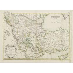
Turquie d'Europe et partie de celle d'Asie..
Attractive map centered on the Aegean Sea, encompassing the whole Balkan Peninsula and part of Turkey.It includes also Crete and Cyprus. Decorated with a decorative title...
Date: Paris, ca 1783
Selling price: ????
Please login to see price!
Sold in 2011
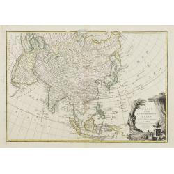
L'Asie divisée en ses principaux Etats..
Attractive map of Asia, ornated with a sumptuous title cartouche. Boundaries outlined in hand color.Prepared by Le Sieur Janvier, Jean denis [Robert], French geographer a...
Date: Paris, ca 1783
Selling price: ????
Please login to see price!
Sold
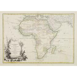
L'Afrique divisée en ses principaux Etats..
Attractive map of Africa, ornated with a decorative title cartouche showing luxuriant nature and native animals. Boundaries outlined in hand color.Prepared by Le Sieur Ja...
Date: Paris, ca 1783
Selling price: ????
Please login to see price!
Sold
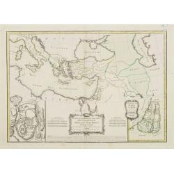
Carte des Regions et des Lieux dont il est parlé dans le Nouveau Testament..
A map of the near East at the time of Christ. Ornated with a decorative title cartouche. Boundaries outlined in hand color.Inset plan of Jerusalem in the bottom left corn...
Date: Paris ca 1783
Selling price: ????
Please login to see price!
Sold

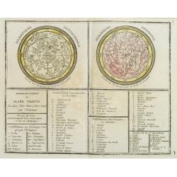
Sphère de Ptolomée.. Rose de Boussole..
The Ptolemaic, parallel and right spheres are represented in the left hand side while in the right hand side are a compass rose and a wind rose.From theAtlas moderne ou c...
Date: Paris, ca 1783
Selling price: ????
Please login to see price!
Sold
Carte des Gouvernements de d' Anjou, et du Saumurois, de la Touraine, du Poitot, du Pays d' Aunis, Saintonge-Angoumois.
Jean Lattré, Paris-based engraver and publisher. Worked with Robert de Vaugondy, J. Janvier and R. Bonne. " Atlas Monderne', 1771, 1783 , 1793. Rigobert Bonne (1727...
Date: Paris, 1783
Selling price: ????
Please login to see price!
Sold in 2009
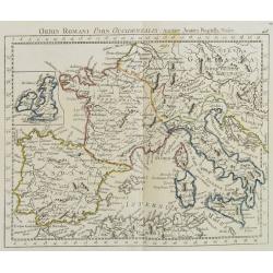
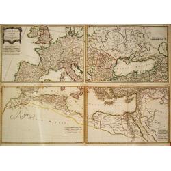
Orbis Romani Pars Occidentalis. . .
Map of the ancient Roman Empire, prepared by J.B.Nolin and published by Monhare for his Atlas Général a l\'usage des colleges et maisons d\'education.. Louis Joseph Mon...
Date: Paris, 1783
Selling price: ????
Please login to see price!
Sold in 2009
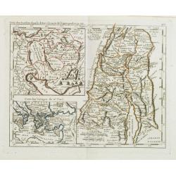
Camp des Israelites dans le désert à la sortie de l'Egipte . . . / La Judée ou Terre Sainte. . . / Carte des voyages de St. Paul.
Three maps on one sheet. The largest map showing Palestine north of the Death Sea, dived in 12 Tribes. The left a map of the travels of St. Paul and a detailed map of the...
Date: Paris, 1783
Selling price: ????
Please login to see price!
Sold in 2008
Représentation du Globe céleste En deux Plans Hémisphères Coupés par l'Ecliptique.
Armillary Sphere prepared by J.B.Nolin and published by Monhare for his Atlas Général a l'usage des colleges et maisons d'education.. Louis Joseph Mondhare was active i...
Date: Paris, 1783
Selling price: ????
Please login to see price!
Sold in 2008
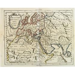
Orbis Veteribus Noti Tabula Nova. . .
Uncommon map of the Ancient world prepared by J.B.Nolin and published by Monhare for his Atlas Général a l'usage des colleges et maisons d'education.. Louis Joseph Mond...
Date: Paris, 1783
Selling price: ????
Please login to see price!
Sold
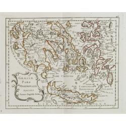
Graeciae Pars Meridionalis. . .
Rare map of Greece prepared by J.B.Nolin and published by Monhare for his Atlas Général a l'usage des colleges et maisons d'education.. Louis Joseph Mondhare was active...
Date: Paris, 1783
Selling price: ????
Please login to see price!
Sold in 2008
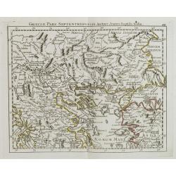
Graeciae Pars Septentrionalis?
Rare map of northern part of Greece, prepared by J.B.Nolin and published by Monhare for his Atlas Général a l'usage des colleges et maisons d'education.. Louis Joseph M...
Date: Paris, 1783
Selling price: ????
Please login to see price!
Sold in 2008
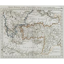
Orbi Romani Pars Orientalis. . .
Unusual map of Ancient Turkey, including a curiously shaped Cyprus, prepared by J.B.Nolin and published by Monhare for his Atlas Général a l'usage des colleges et maiso...
Date: Paris, 1783
Selling price: ????
Please login to see price!
Sold in 2009
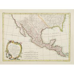
Carte du Mexique ou de la Nlle. Espagne..
Attractive map centered on Mexico, covering the whole Central America and the southern part of the United States.Ornated with a rococo title cartouche. Boundaries outline...
Date: Paris, ca 1783
Selling price: ????
Please login to see price!
Sold in 2008
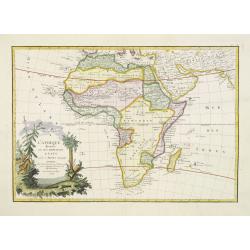
L'Afrique divisée en ses principaux Etats. . .
Attractive map of Africa, ornated with a decorative title cartouche showing luxuriant nature and native animals. Boundaries outlined in hand color.Prepared by Le Sieur Ja...
Date: Paris, ca 1783
Selling price: ????
Please login to see price!
Sold in 2011
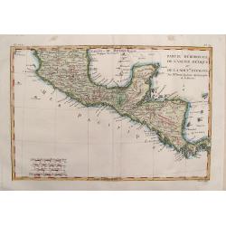
Partie Meridionale de L'Ancien Mexique .
Fine map of Southern Mexico & Central America from Bonne's "Atlas de Toutes les Parties Connues du Globe Terrestre". BONNE, RIGOBERT (1729-1795). Bonne was...
Date: Paris, 1783
Selling price: ????
Please login to see price!
Sold in 2014
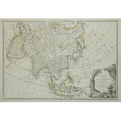
L'Asie divisée en ses principaux Etats ...
Attractive map of Asia, ornated with a sumptuous title cartouche. Boundaries outlined in hand color.Prepared by Le Sieur Janvier, Jean Denis [Robert], French geographer a...
Date: Paris, c.1783
Selling price: ????
Please login to see price!
Sold in 2011
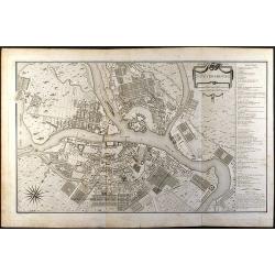
St. Petersbourg
Large city plan of St. Petersburg in Russia. From the Atlas Volume of \"Histoire physique, morale, civile et politique de la Russie Ancienne\" by N. G. Le Clerc...
Date: Paris, 1783
Selling price: ????
Please login to see price!
Sold in 2008

