Browse Listings
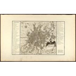
Moskou
Engraved map of Moscow with legend on left and right side. From the Atlas Volume of "Histoire physique, morale, civile et politique de la Russie Ancienne" by N....
Date: Paris, 1783
Selling price: ????
Please login to see price!
Sold in 2008
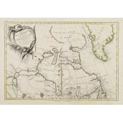
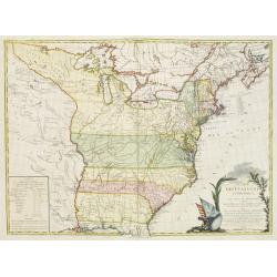
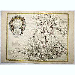
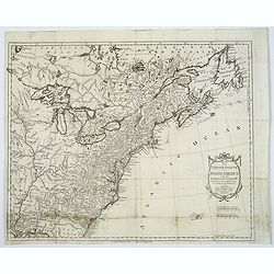
Partie de l'Amérique Septentrionale qui comprend le Canada.. La Floride &c..
Attractive map centered on the Bay of Hudson, ornated with a rococo title cartouche. Boundaries outlined in hand color.From theAtlas moderne ou collection de cartes sur t...
Date: Paris, ca 1783
Selling price: ????
Please login to see price!
Sold
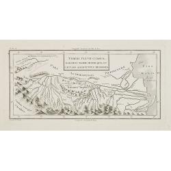
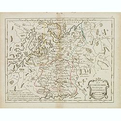
Tereki Fluvii Cursus, Kabarda major minor-que, et caucaso adjacentes regiones.
Map of Kabarda and the adjacent regions. The Kabardino-Balkaria Republic is located in the far southwestern Russian Federation, on the border with Georgia. To the right t...
Date: Paris, ca. 1783
Selling price: ????
Please login to see price!
Sold in 2009
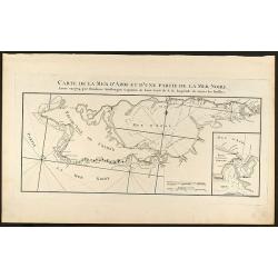
Carte de la Mer d\'Azof et d\'une Partie de la Mer Noire
Engraved map of the Crimean Peninsula with the Black Sea and the Sea of Azov in Russia. From the Atlas Volume of \"Histoire physique, morale, civile et politique de ...
Date: Paris, 1783
Selling price: ????
Please login to see price!
Sold in 2009
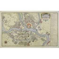
St. Petersbourg.
Large town-plan of St. Petersburg. From the Atlas Volume of "Histoire physique, morale, civile et politique de la Russie Ancienne" by N. G. Le Clerc. The plan i...
Date: Paris, 1783
Selling price: ????
Please login to see price!
Sold in 2009
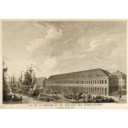
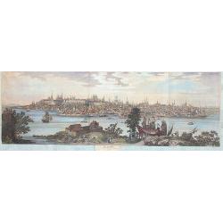
Vue de la Bourse et du Magazin des Marchandises en remontant la petite Neva
Beautiful view of the stock exchange and warehouse of St. Petersburg in Russia. From the Atlas Volume of "Histoire physique, morale, civile et politique de la Ru...
Date: Paris, 1783
Selling price: ????
Please login to see price!
Sold in 2009
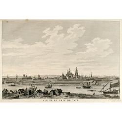
Vue de la Ville de Tver
Beautiful view of the city Twer between Moscow and St. Petersburg in Russia. From the Atlas Volume of "Histoire physique, morale, civile et politique de la Russi...
Date: Paris, 1783
Selling price: ????
Please login to see price!
Sold in 2009
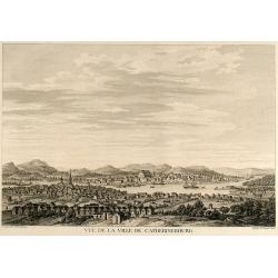
Vue de la Ville de Catherinebourg
Beautiful view of the city Yekaterinburg / Sverdlovsk in Russia. From the Atlas Volume of "Histoire physique, morale, civile et politique de la Russie Ancienne&a...
Date: Paris, 1783
Selling price: ????
Please login to see price!
Sold in 2009
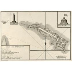
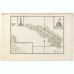
Plan de Kronstadt
Engraved map of Kronstadt / Kronshtadt on the Kotlin Island west of St. Petersburg in Russia. From the Atlas Volume of "Histoire physique, morale, civile et politiqu...
Date: Paris, 1783
Selling price: ????
Please login to see price!
Sold in 2009
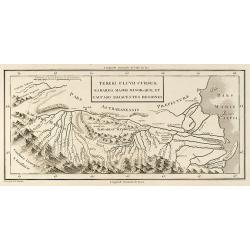
Tereki Fluvii Cursus, Kabarda major minor-que et Caucaso adjacentes Regiones
Engraved map of the Terek River with parts of the Caspian Sea in Russia. From the Atlas Volume of "Histoire physique, morale, civile et politique de la Russie Ancien...
Date: Paris, 1783
Selling price: ????
Please login to see price!
Sold in 2009
Plan et coupe horisontale du labyrinte souterrain de Koungour Renvoi
Engraved map of the Urals mit the town Kungur in Russia. From the Atlas Volume of "Histoire physique, morale, civile et politique de la Russie Ancienne" by N. G...
Date: Paris, 1783
Selling price: ????
Please login to see price!
Sold in 2009
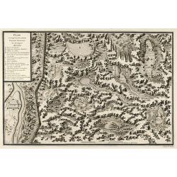
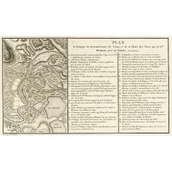
Plan des Expéditions faites par le Gal. Weissman de l\'autre côté du Danube contre Tultschi & Isaktschi. Attaque de Tultschi le 4 Avril 1771
Engraved map of the Danube River between Isaccea, Tulcea in Romania and Izmail in Moldavia. With detail of the expeditions of General Weissman in 1771. From the Atlas Vol...
Date: Paris, 1783
Selling price: ????
Please login to see price!
Sold in 2010
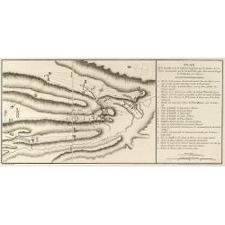
Plan de l\'Attaque du Retranchement, du Camp, et de la Flotte des Turcs par le Gal. Weisman, près de Tultschi, le 30 Juin 1771
Engraved map of the Danube River between Tulcea in Romania and Izmail in Moldavia. With detail of the expeditions of General Weissman in 1771. From the Atlas Volume of &q...
Date: Paris, 1783
Selling price: ????
Please login to see price!
Sold in 2010
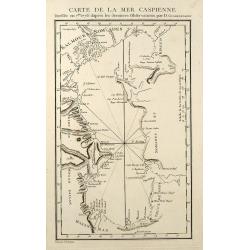
Carte de la Mer Caspienne
Engraved map of the Caspian Sea. From the Atlas Volume of "Histoire physique, morale, civile et politique de la Russie Ancienne" by N. G. Le Clerc. Engraved by ...
Date: Paris, 1783
Selling price: ????
Please login to see price!
Sold in 2009
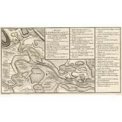
Plan de la Bataille & de la Victoire remportée par les Russes sur les Turcs commandés par le Grand Visir près de la riviere Kagul en Bessarabie. le 21 Julliet, 1770
Engraved map of the Battle of Cahul in today Moldavia during the Russo-Turkish War 1768-1774 on 21 July 1770. From the rare Atlas Volume of "Histoire physique, moral...
Date: Paris, 1783
Selling price: ????
Please login to see price!
Sold in 2009
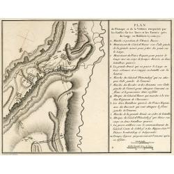
Plan de l'Attaque & de la Victoire remportée par les Russes sur les Turcs et les Tartars près du Large en Moldavie le 7 Julliet, 1770
Engraved map of the Battle of at the Large in today Moldavia during the Russo-Turkish War 1768-1774 on 7 July 1770. From the rare Atlas Volume of "Histoire physique,...
Date: Paris, 1783
Selling price: ????
Please login to see price!
Sold in 2009
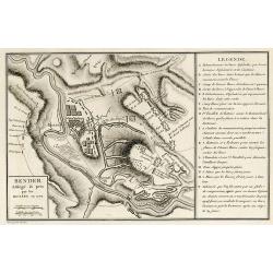
Bender Assiégé & pris par les Russes en 1770
Engraved map of the Battle of Bender in today Moldavia during the Russo-Turkish War 1768-1774 in 1770. From the rare Atlas Volume of "Histoire physique, morale, civi...
Date: Paris, 1783
Selling price: ????
Please login to see price!
Sold in 2009
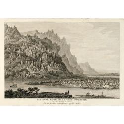
Vue d'une Partie de la Ville d'Iakoutsk Sur le Rive Occidentale de la Léna, et des Rochers Colonniformes appellés Stolbi
Beautiful view of the city Yakutsk at the Lena River in Siberia. From the Atlas Volume of "Histoire physique, morale, civile et politique de la Russie Ancienne&a...
Date: Paris, 1783
Selling price: ????
Please login to see price!
Sold in 2009
Kiakta
Beautiful view of the city Kyakhta at the Kyakhta River in Russia close to the Mongolian border. From the Atlas Volume of "Histoire physique, morale, civile et polit...
Date: Paris, 1783
Selling price: ????
Please login to see price!
Sold in 2009
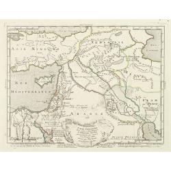
Carte générale pour servir à l'Intelligence de l'Histoire Sainte..
Fine map of the Middle East, including the Holy Land, Cyprus, Iran and Iraq, etc.Philippe Buache was one of the most active proponents of the so-called school of theoreti...
Date: Paris, 1783
Selling price: ????
Please login to see price!
Sold in 2010
Le cercle de Baviere. . .
Fine map of Bavaria with a decorative title and scale cartouche. Including the towns of Regensburg, Passau, etc.Alexis-Hubert Jaillot (1632-1712), was a French cartograph...
Date: Paris, 1783
Selling price: ????
Please login to see price!
Sold in 2012
Le cours du Danube dédié au roy. . .
A later edition of this beautiful and detailed map of the river Danube, originally published by Du Val in 1703. Here with the date "1783" and the address change...
Date: Paris, 1783
Selling price: ????
Please login to see price!
Sold in 2011
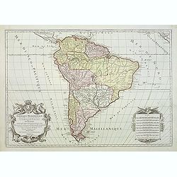
Amerique Meridionale divisée en ses principales parties ou sont distingués les uns des autres LES ETATS SUIVANTS qu'ils appartiennent presentement aux FRANCOIS, CASTILLANS, PORTUGAIS HOLLANDOIS etc. . .
Large map of South America, by Hubert Jaillot after Nicolas Sanson and updated by Desnos.
Date: Paris, after 1783
Selling price: ????
Please login to see price!
Sold in 2011
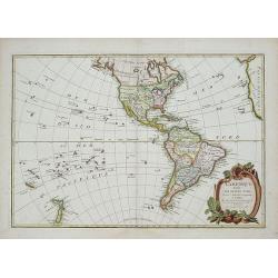
L'Amerique divisee Par Grand Etats by Jean Janvier.
Second edition of Janvier's map, reworked by Giovanni Antonio Rizzi-Zannoni.This is the later edition of this copper engraved map of the Americas with interesting norther...
Date: Paris, 1783
Selling price: ????
Please login to see price!
Sold in 2018
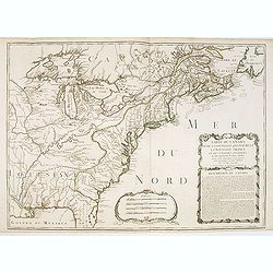
![[No title] East coast of US.](/uploads/cache/23469-250x250.jpg)
[No title] East coast of US.
Covering the French Louisiana and the British Colonies with their western boundary on the Mississippi River.Nice detail, particularly of the French forts and Indian villa...
Date: Paris ca 1783
Selling price: ????
Please login to see price!
Sold in 2014
CARTE DES ETATS-UNIS D'AMERIQUE, et du Cours du Mississipi. . .
Separate publication. First state of three. First published in 1783 by Desnos, then by Esnauts et Rapilly and was re-issued in 1787. Louis Brion de la Tour was a military...
Date: Paris, 1783
Selling price: ????
Please login to see price!
Sold in 2013
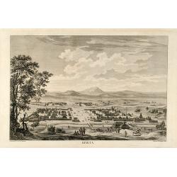
Cazan 1767
A marvellous, spectacular and large panoramic view of Kasan across the river Volga.
Date: Paris, 1783
Selling price: ????
Please login to see price!
Sold in 2013
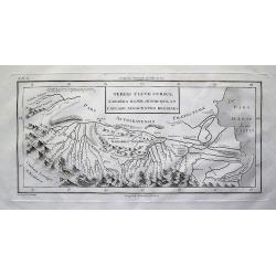
Tereki Fluvii Cursus, Kabarda major minor-que et Caucaso adjacentes Regiones
Detailed map of the Terek River in present day Georgia and Russia, and parts of the Caspian Sea. Names many rivers and places. With impressive representation of the Cauca...
Date: Paris, 1783
Selling price: ????
Please login to see price!
Sold in 2012
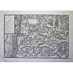
Plan et coupe horisontale du labyrinte souterrain de Koungour Renvoi
Very interesting map of parts of the Ural mountains near Kungur city and the Sylwa River. Shows the "underground labyrinth", with the legend explaining sand hil...
Date: Paris, 1783
Selling price: ????
Please login to see price!
Sold in 2012
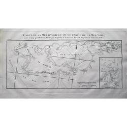
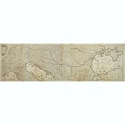
Carte de la Mer d'Azof et d'une Partie de la Mer Noire Levée en 1774 par Monsieur Kinsbergen...
Very detailed map of the Crimea peninsula, the Sea of Azov, and the Black Sea. Shows many place names, and depth soundings. With inset map "Plan du Détroit de Zabac...
Date: Paris, 1783
Selling price: ????
Please login to see price!
Sold in 2012
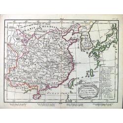
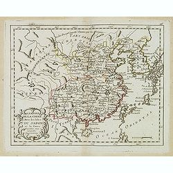
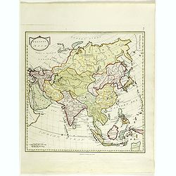
L'Empire de la Chine.
Attractive map of China, Korea, and Japan by Lattre.
Date: Paris, 1783
Selling price: ????
Please login to see price!
Sold in 2012
Carte Du Canada et de La Louisiane Qui Forment La Nouvelle France et Des Colonies Anglois . . . 1756
An important and rare pre-revolutionary French Indian war map by Nolin of Canada and the British Colonies, south to the Florida Peninsula, and from the eastern coastline ...
Date: Paris, 1783
Selling price: ????
Please login to see price!
Sold
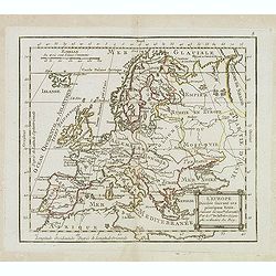
L'Europe Divisée Suivant ses principaux Etats . . .
Scarce map of Europe prepared by de La Fosse and published by L.J. Mondhare for his Atlas Général a l'usage des colleges et maisons d'education.. Louis Joseph Mondhare ...
Date: Paris, 1783
Selling price: ????
Please login to see price!
Sold in 2019
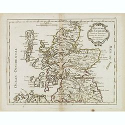
Royaume d'Ecosse. . .
Scarce map of Scotland prepared by Nolin and published by L.J. Mondhare for his Atlas Général a l'usage des colleges et maisons d'education.. Louis Joseph Mondhare was ...
Date: Paris, 1783
Selling price: ????
Please login to see price!
Sold in 2013
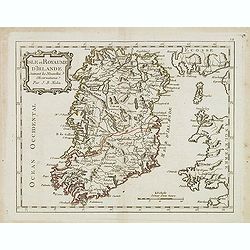
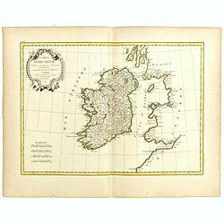
Isle et Royaume d'Irlande. . .
Scarce map of Ireland prepared by Nolin and published by L.J. Mondhare for his Atlas Général a l'usage des colleges et maisons d'education.. Louis Joseph Mondhare was a...
Date: Paris, 1783
Selling price: ????
Please login to see price!
Sold in 2016
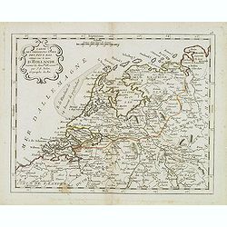
Carte des provinces Unies des Pays Bas connue sous le nom d'Hollande. . .
Scarce map of The Netherlands prepared by Nolin and published by L.J. Mondhare for his Atlas Général a l'usage des colleges et maisons d'education.. Louis Joseph Mondha...
Date: Paris, 1783
Selling price: ????
Please login to see price!
Sold in 2014
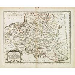
Etats de la couronne de Pologne . . .
Scarce map of Poland prepared by Nolin and published by L.J. Mondhare for his Atlas Général a l'usage des colleges et maisons d'education.. Louis Joseph Mondhare was ac...
Date: Paris, 1783
Selling price: ????
Please login to see price!
Sold in 2013
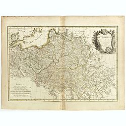
La Russie d' Europe divisée par gouvernemens . . .
Scarce map of Russia prepared by Nolin and published by L.J. Mondhare for his Atlas Général a l'usage des colleges et maisons d'education.. Louis Joseph Mondhare was ac...
Date: Paris, 1783
Selling price: ????
Please login to see price!
Sold in 2014
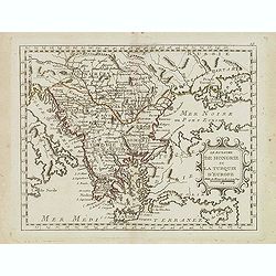
Le Royaume de Hongrie et la Turquie d'Europe. . .
Scarce map of Greece, Romania, Bulgaria and Hungary prepared by Nolin and published by L.J. Mondhare for his Atlas Général a l'usage des colleges et maisons d'education...
Date: Paris, 1783
Selling price: ????
Please login to see price!
Sold in 2017
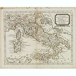
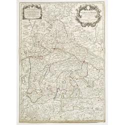
L'Italie divisée en ses différents Etats Royaumes et Republiques. . .
Scarce map of Italy prepared by Nolin and published by L.J. Mondhare for his Atlas Général a l'usage des colleges et maisons d'education.. Louis Joseph Mondhare was act...
Date: Paris, 1783
Selling price: ????
Please login to see price!
Sold in 2023
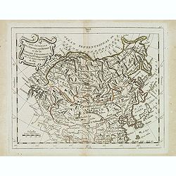
Carte générale de l'Empire des Russes et de la Tartarie universelle. . .
Scarce map of Russia prepared by Nolin and published by L.J. Mondhare for his Atlas Général a l'usage des colleges et maisons d'education.. Louis Joseph Mondhare was ac...
Date: Paris, 1783
Selling price: ????
Please login to see price!
Sold in 2013
L'empire de la Chine avec les Isles du Japon. . .
Scarce map of China, including Korea, Taiwan and southern part of Japan, prepared by Nolin and published by L.J. Mondhare for his Atlas Général a l'usage des colleges e...
Date: Paris, 1783
Selling price: ????
Please login to see price!
Sold in 2017
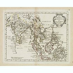
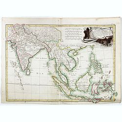
Les Indes oriental et leur archipel. . .
Scarce map of India and South East Asia, nice detail in the Philippines, prepared by Nolin and published by L.J. Mondhare for his Atlas Général a l'usage des colleges e...
Date: Paris, 1783
Selling price: ????
Please login to see price!
Sold in 2015
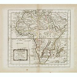
L'Afrique suivant les dernier. . .
Scarce map of Africa, prepared by Nolin and published by L.J. Mondhare for his Atlas Général a l'usage des colleges et maisons d'education.. Louis Joseph Mondhare was a...
Date: Paris, 1783
Selling price: ????
Please login to see price!
Sold in 2014
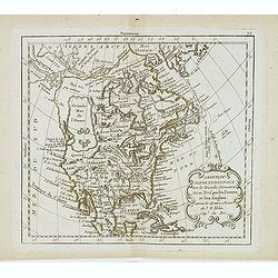
Amérique septentrionale avec les nouvelles découvertes. . .
Large Mer de L'Quest. Rare map of North America, showing a remarkable NW Coast of America, including the recently discovered sea (by the Russians) of the West. The NW Coa...
Date: Paris, 1783
Selling price: ????
Please login to see price!
Sold in 2019
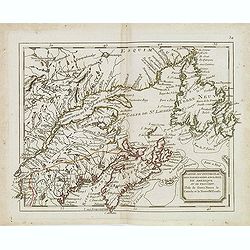
Partie septentrional des possessions angloise en Amerique. . .
Rare map of eastern Canada, showing the are from Montreal, Lake Champlain till New Foundland. The map is filled with place names, Indian villages, early forts, French gar...
Date: Paris, 1783
Selling price: ????
Please login to see price!
Sold in 2014
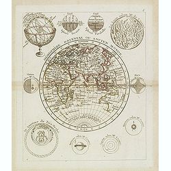
Hémisphère Oriental ou Ancien Monde.
Scarce map of the western hemisphere with Africa, Europe, Asia and Australia. The hemisphere is surrounded by the moon, sun, a sphere and celestial systems after Cassini....
Date: Paris, 1783
Selling price: ????
Please login to see price!
Sold in 2013
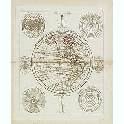
Hémisphère Oriental ou Nouveau Monde.
Scarce map of the eastern hemisphere with North and South America. The hemisphere is surrounded by the moon, sun, a sphere and celestial systems after Copernicus, Ptolemy...
Date: Paris, 1783
Selling price: ????
Please login to see price!
Sold in 2021
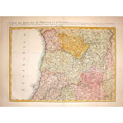
Carte des Royaumes de Portugal et D'Algarue.
Detailed engraved map of the northern part of Portugal including cities, towns, rivers, lakes, forests and mountains. Giovanni Antonio Bartolomeo Rizzi Zannoni (1736 - 1...
Date: Paris, 1783
Selling price: ????
Please login to see price!
Sold in 2015
Carte Generale de la Pologne avec tous les Etats qui en dependent..
Attractive map of Poland, ornated with a rococo title cartouche. Boundaries outlined in hand color.Prepared by Giovanni Antonio Bartolomeo Rizzi Zannoni, one of the leadi...
Date: Paris ca 1783
Selling price: ????
Please login to see price!
Sold in 2014

Lady Elizabeth Grey Petitioning Edward IV To Restore Her Lands.
Fine hand-colored copper engraving featuring Lady Elizabeth Grey. Engraved by Grignion from a picture by Edwards and published by Alexander Hogg in London in 1783.
Date: London, 1783
Selling price: ????
Please login to see price!
Sold in 2016
Carte de L'Empire D'Alemagne Avec Les Etats de Boheme Dressee.
Striking map featuring south western Germany, Luxemburg and part of Austria. Lovely cartouche with double headed crowned eagle with sword, musical instruments, canon &am...
Date: Paris, c1783
Selling price: ????
Please login to see price!
Sold in 2019
Carte des Côtes de Barbarie ou les Royaumes de Maroc.. Circonvoisins...
Attractive map of North Africa, ornated with a decorative title cartouche. Boundaries outlined in hand color. From the "Atlas moderne ou collection de cartes sur tou...
Date: Paris, 1783
Selling price: ????
Please login to see price!
Sold in 2016
The Doo=AB, from Allahabad to Kalpy. .
Detailed map of part of the rivers Ganges and Jumnah.From the English original edition published in London in 1783 by Brown under the title "Memoir of a Map of Hindu...
Date: Londen, 1783
Selling price: ????
Please login to see price!
Sold in 2015
Plan de Kronstadt.
Map of the Island, Harbors and Fortifications of Kronstadt off St. Petersburg. From the Atlas Volume of "Histoire physique, morale, civile et politique de la Russie ...
Date: Paris, 1783
Selling price: ????
Please login to see price!
Sold in 2018
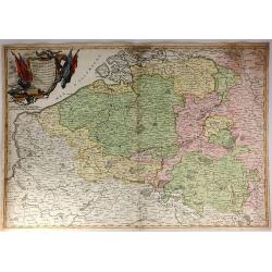
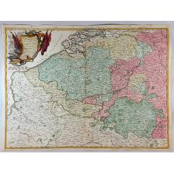
Partie Meridionale Des Pays Bas.
A pleasing example of Jean Janvier's 1783 decorative map of the southern portions of the Pays Bas, or Belgium and Luxembourg. It covers modern day Belgium and Luxembourg,...
Date: Paris, 1783
Selling price: ????
Please login to see price!
Sold in 2018
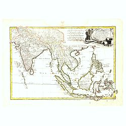
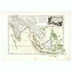
Les Indes Orientales et leur Archipel. . .
General map of Indonesia, extending from India to the Philippines and New Guinea.Ornated with a decorative title cartouche. Boundaries outlined in hand color.From theAtla...
Date: Paris, ca 1783
Selling price: ????
Please login to see price!
Sold in 2016
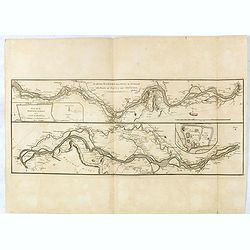
The river Ganges from Patna to Surdah . . .
Detailed map of part of the rivers Ganges and Jumnah.From the English original edition published in London in 1783 by Brown under the title "Memoir of a Map of Hindu...
Date: Londen, 1783
Selling price: ????
Please login to see price!
Sold in 2016
Les Indes Orientales et leur Archipel. . .
General map of Indonesia, extending from India to the Philippines and New Guinea.Ornated with a decorative title cartouche. Boundaries outlined in hand color.From theAtla...
Date: Paris, ca 1783
Selling price: ????
Please login to see price!
Sold in 2017
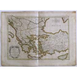
Turquie d' Europe
This finely engraved map is roughly centered on Greece, including the islands of Crete and Cyprus. The map covers the region from Bosnia and Serbia to the Black Sea and C...
Date: Paris, 1783
Selling price: ????
Please login to see price!
Sold in 2016
Carte du Canada, qui comprend la partie septentrionale..
A terrific example of Dezuache's re-issue of Guillaume De L'Isle's seminal map of Canada, the Great Lakes and Upper Midwes. This state is highly important, as it names th...
Date: Paris, 1703 / 1783
Selling price: ????
Please login to see price!
Sold in 2016
![[4 maps] Carte Hydro-Geo-Graphique des Indes Orientales en deça et au dela du Gange avec leur Archipel.. .](/uploads/cache/38416-250x250.jpg)
[4 maps] Carte Hydro-Geo-Graphique des Indes Orientales en deça et au dela du Gange avec leur Archipel.. .
A 4 sheet map south and east Asia, from Afghanistan in the west, across to China in the east, from the southern tip of the Indian peninsular and Ceylon (Sri Lanka) across...
Date: Paris, ca. 1783
Selling price: ????
Please login to see price!
Sold in 2016
Les Indes Orientales et leur Archipel. . .
General map of Indonesia, extending from India to the Philippines and New Guinea.Ornated with a decorative title cartouche. Boundaries outlined in hand color.From theAtla...
Date: Paris, ca 1783
Selling price: ????
Please login to see price!
Sold in 2018
Map of the United States in North America: with the British, French and Spanish Dominions adjoining, according to the Treaty of 1783.
One of the earliest obtainable English Maps to name the newly independent United States of America.The map shows the United States extending to the Mississippi River, wit...
Date: London, 1783
Selling price: ????
Please login to see price!
Sold in 2017
Partie Meridionale des Pays Bas Qui Comprend les Provinces de Brabant, Gueldre, Limbourg, Luxembourg, Hanaut, Namur, Flandre, cambresis et Artoir...
A striking example of Janvier's decorative map of the southern portions of the Pays Bas, or Belgium and Luxembourg. It covers modern day Belgium and Luxembourg, with adja...
Date: Paris, 1783
Selling price: ????
Please login to see price!
Sold in 2017

View of the Seraglio at Constantinople.
A rare engraved view after Metz, with people in the foreground and the city in the background. A ship and several small boats are on the river. This is the earliest state...
Date: London, 1783
Selling price: ????
Please login to see price!
Sold in 2018
Present Asia.
Map of sea of Korea.
Date: United States, 1783
Selling price: ????
Please login to see price!
Sold in 2018
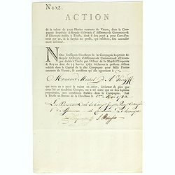
Share of 1000 Florins to Michel de Knyff. N° 132.
Share of 1000 Florins, paid in four tranches at 250 Florins of Vienna, from "Compagnie Imperiale & Royale Octroyee d'Assurance de Commerce & d'escompte."...
Date: Trieste, 1782 - 1783
Selling price: ????
Please login to see price!
Sold in 2018
![[Two maps] L'Italie divisée en ses différents etats, royaumes et républiques . . .](/uploads/cache/42816-250x250.jpg)
[Two maps] L'Italie divisée en ses différents etats, royaumes et républiques . . .
Attractive map of Italy, ornated with a decorative title cartouche. Boundaries outlined in hand color.Prepared by Le Sieur Janvier, Jean Denis [Robert], French geographer...
Date: Paris, ca 1783
Selling price: ????
Please login to see price!
Sold in 2018
![[Two maps] Partie méridionale des Pays-Bas . . .](/uploads/cache/42817-250x250.jpg)
[Two maps] Partie méridionale des Pays-Bas . . .
Attractive map of the Netherlands, ornated with a decorative title cartouche. Boundaries outlined in hand color.Prepared by Le Sieur Janvier, Jean Denis [Robert], French ...
Date: Paris, ca 1783
Selling price: ????
Please login to see price!
Sold in 2019
Carte d'Irlande Projettée et assujettie aux Observations Astronomiques. . .
Attractive map of Ireland, ornated with a decorative title cartouche. Boundaries outlined in hand color.Prepared by Le Sieur Janvier, Jean Denis [Robert], French geograph...
Date: Paris, ca 1783
Selling price: ????
Please login to see price!
Sold in 2019
Carte generale de la Pologne . . .
Attractive map of Poland, ornated with a decorative title cartouche. Boundaries outlined in hand color.Prepared by Le Sieur Janvier, Jean Denis [Robert], French geographe...
Date: Paris, ca 1783
Selling price: ????
Please login to see price!
Sold in 2018
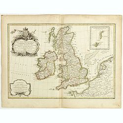
Les Isles Britanniques comprenant les Royaumes d'Angleterre, d'Ecosse et d'Irlande . . .
Attractive map of the British isles, ornated with a decorative title cartouche. Boundaries outlined in hand color.Prepared by Le Sieur Janvier, Jean Denis [Robert], Frenc...
Date: Paris, ca 1783
Selling price: ????
Please login to see price!
Sold in 2019
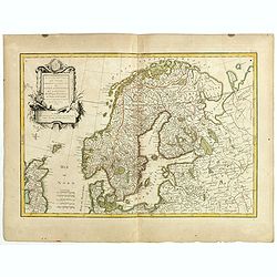
Les Couronnes du Nord comprenant les royaumes du Suede, Danemark et Norwege . . .
Attractive map of Scandinavia, ornated with a decorative title cartouche. Boundaries outlined in hand color.Prepared by Le Sieur Janvier, Jean Denis [Robert], French geog...
Date: Paris, ca 1783
Selling price: ????
Please login to see price!
Sold in 2019
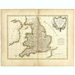
Carte du Royaume d'Angleterre . . .
Attractive map of the United Kingdom, ornated with a decorative title cartouche. Boundaries outlined in hand color.Prepared by Le Sieur Janvier, Jean Denis [Robert], Fren...
Date: Paris, ca 1783
Selling price: ????
Please login to see price!
Sold in 2019
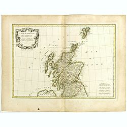
Carte du Royaume d'Ecosse . . .
Attractive map of Scotland, ornated with a decorative title cartouche. Boundaries outlined in hand color.Prepared by Le Sieur Janvier, Jean Denis [Robert], French geograp...
Date: Paris, ca 1783
Selling price: ????
Please login to see price!
Sold in 2019
![[4 maps] Carte du Gouvernement de Bretagne . . . / Carte du Gouvernement de l'Isle de France . . . / Carte des Gouvernements de Flandre Françoise, / Carte du Gouvernement de Normandie...](/uploads/cache/42824-250x250.jpg)
[4 maps] Carte du Gouvernement de Bretagne . . . / Carte du Gouvernement de l'Isle de France . . . / Carte des Gouvernements de Flandre Françoise, / Carte du Gouvernement de Normandie...
Four attractive maps of French provinces, ornated with a decorative title cartouche. Boundaries outlined in hand color.Prepared by Le Sieur Janvier, Jean Denis [Robert], ...
Date: Paris, ca 1783
Selling price: ????
Please login to see price!
Sold in 2020
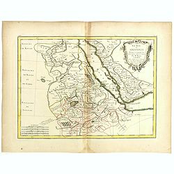
Nubie et Abissinie . . .
Attractive map of East Africa, ornated with a decorative title cartouche. Boundaries outlined in hand color.Prepared by Le Sieur Janvier, Jean Denis [Robert], French geog...
Date: Paris, ca 1783
Selling price: ????
Please login to see price!
Sold in 2019
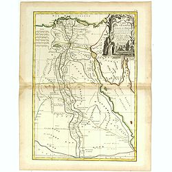
Carte de l'Egypte ancienne et moderne . . .
Attractive map of Egypt, ornated with a decorative title cartouche. Boundaries outlined in hand color.Prepared by Le Sieur Janvier, Jean Denis [Robert], French geographer...
Date: Paris, ca 1783
Selling price: ????
Please login to see price!
Sold in 2019
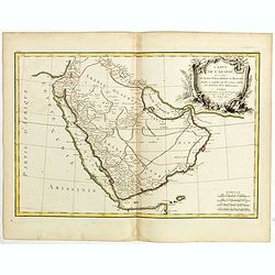
Carte de l'Arabie qui se divise en Arabie Pétrée, Deserte et Heureuse . . .
Attractive map of Arabia, ornated with a decorative title cartouche. Boundaries outlined in hand color.Prepared by Le Sieur Janvier, Jean Denis [Robert], French geographe...
Date: Paris, ca 1783
Selling price: ????
Please login to see price!
Sold in 2018

