Browse Listings
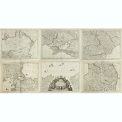
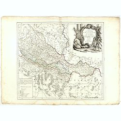
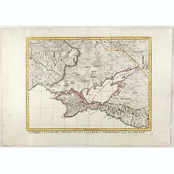
Carte de la partie septentrionale de l'empire Otoman. contenant la Crimée, la Moldavie, la Valakie, la Bulgarie, avec la nouvelle Russie, les gouvernement d'Astracan, et de Voronez, les Tatares cosaques &c. / par le Sr. Rizzi Zannoni.
A detailed six sheet map of the Northern Part of the Ottoman Empire, centered on the Black Sea including parts of Romania, Hungary and Bulgaria. Prepared by Giovanni Anto...
Date: Venice, 1784
Selling price: ????
Please login to see price!
Sold in 2015
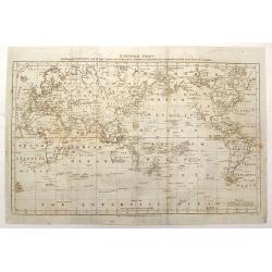
A New General Chart: Exhibiting the Discoveries made by Capt'n James Cook in His First, Second and Third Voyages; with the Tracks of the Ships Under His Command
An important map featuring the three voyages of Captain Cook and including the tracks of these voyages including place names, dates and notes. Interestingly centered on t...
Date: London, 1784
Selling price: ????
Please login to see price!
Sold in 2015
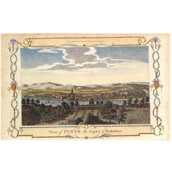
View of Perth, the Capital of Perthshire.
Pleasing hand colored view of Perth, Scotland, from an edition of "THE NEW BRITISH TRAVELLER" published in London by Alexander Hogg in 1784. The engraving was b...
Date: London, 1784
Selling price: ????
Please login to see price!
Sold in 2018
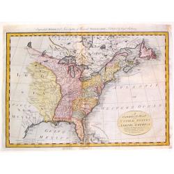
A Correct Map of the United States of North America Including the British and Spanish territories, Carefully Laid Down Agreeable to the Treaty of 1784
One of the first maps published after the American Revolution, after the TREATY of PARIS. The west of the U.S. was Louisiana and New Mexico and west of the Mississippi ma...
Date: London, 1784
Selling price: ????
Please login to see price!
Sold in 2015
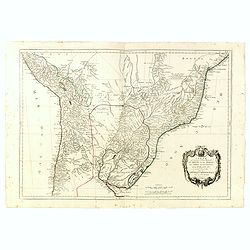
Carte qui représente la Partie Méridionale du Brésil et du Perou..
Finely and crisply engraved map representing the central part of South America, including part of Brazil, Chile and Peru as well as Uruguay and Paraguay.It covers the Atl...
Date: Venice, 1776 - 1784
Selling price: ????
Please login to see price!
Sold in 2015

(Frontispiece to Walpoole's New & Complete British Traveller.)
An interesting title page showing a globe and a map. Below with text: "This Superbly Elegant Frontispiece Represents Britannia (attended by Prudence, Justice, Temper...
Date: London, 1784
Selling price: ????
Please login to see price!
Sold in 2017
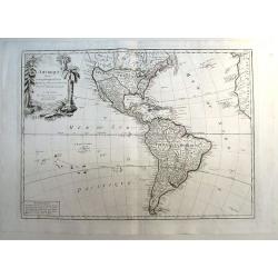
L`Amerique Divisee en Ses Principaux Etats Assujettie aux Observations Astronomiqes...
Copper engraved map; overall size 53 x 75 cm by Robert Janvier, published by Francesco Santini and Giuseppe Antonio Remondini. This is the 2nd state of the Italian editi...
Date: Venice, 1784
Selling price: ????
Please login to see price!
Sold in 2016
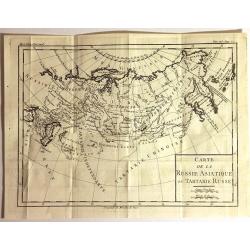
Carte de la Russie Asiatique ou Tartarie Russe
Fine copper engraved engraving featuring the Eastern part of Russia. Engraved by Brion de la Tour, and published in "HISTOIRE UNIVERSELL" by Chez Moutard.
Date: Paris, 1784
Selling price: ????
Please login to see price!
Sold in 2015
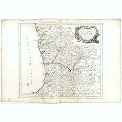
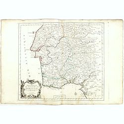
Partie Septentrionale du Royaume de Portugal. . .
Detailed map encompassing the whole northern half of Portugal, with part of the neighboring Spain.Venetian edition of the map by Bellin, to whom Santini gives credit in t...
Date: Venice, 1776 - 1784
Selling price: ????
Please login to see price!
Sold in 2022
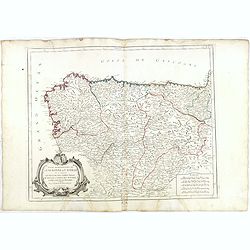
Partie Septentrionale.. Partie Meridionale du Royaume de Portugal..
A detailed map of southern part of Portugal showing the roads, prepared by N.Bellin.Venetian edition of the map by Bellin, to whom Santini gives credit in the cartouche.F...
Date: Venice, 1776 - 1784
Selling price: ????
Please login to see price!
Sold in 2015
Partie Septentrionale de la Couronne de Castille. . .
Detailed map of the north-western part of Spain. Also depicting a small part of southern France. With ornamental title cartouche and noteworthy topographical detail.The m...
Date: Venice, 1776 - 1784
Selling price: ????
Please login to see price!
Sold in 2018
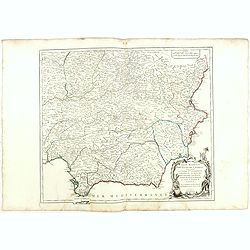
Partie Meridionale des Etats de Castille où se trouvent. . .
A detailed map of the southern half of Spain. Prepared by "Robert de Vaugondy fils," to whom Santini gives credit in the cartouche. From "Atlas Universel&q...
Date: Venice, 1776 - 1784
Selling price: ????
Please login to see price!
Sold in 2018
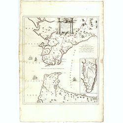
Nouvelle Carte du Détroit de Gibraltar et de l'Isle de Cadix..
Decorative map centered on the Strait of Gibraltar. With an inset plan of Gibraltar, decorative title cartouche and four vessels.From "Atlas Universel" publishe...
Date: Venice, 1776 - 1784
Selling price: ????
Please login to see price!
Sold in 2015
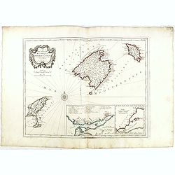
Carte des Isles de Majorque, Minorque, et Yvice. . .
Decorative map representing the Balearic islands. With 2 insets and an ornamental title cartouche.Venetian edition of the map by Bellin, to whom Santini gives credit in t...
Date: Venice, 1776 - 1784
Selling price: ????
Please login to see price!
Sold in 2015
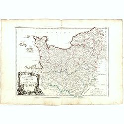
Carte du Gouvernement de Normandie avec celui du Maine et Perche.
Map of Normandy, with ornate title cartouche in lower left bottom. With ornamental title cartouche and noteworthy topographical detail.The map was prepared by the Venetia...
Date: Venice, 1776 - 1784
Selling price: ????
Please login to see price!
Sold
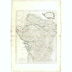
Carte des Gouverneménts d'Anjou et du Saumurois, de la Touraine, du Poitou, du Pays d'Aunis Saintonge - Angoumois. . .
Attractive map of the south western part of France, including isle de Ré and Isle d'Oleron. The map was prepared by R. Bonne, who is given credit in the title cartouche....
Date: Venice, 1777 - 1784
Selling price: ????
Please login to see price!
Sold in 2015
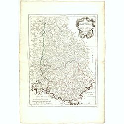
Carte des Gouvernements de Dauphiné et de Province. . .
Attractive map of part of France, covering the eastern part of the Gulf of Lyon with its hinterland. Extending as far as Nice and Grenoble. With ornamental title cartouch...
Date: Venice, 1777 - 1784
Selling price: ????
Please login to see price!
Sold
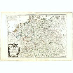
L'Empire d'Allemagne. . .
Detailed map encompassing Germany, the Netherlands, Belgium, Austria, and part of Poland. With ornamental title cartouche and noteworthy topographical detail.The map was ...
Date: Venice, 1776 - 1784
Selling price: ????
Please login to see price!
Sold in 2017
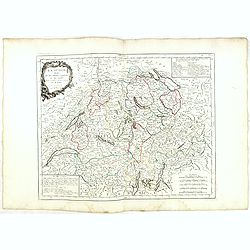
La Suisse divisée en ses treize cantons et ses alliés. . .
Finely and crisply engraved map of Switzerland from Geneva to Lake Constance.With ornamental title cartouche and noteworthy topographical detail.The map was prepared by t...
Date: Venice, 1778 - 1784
Selling price: ????
Please login to see price!
Sold in 2017
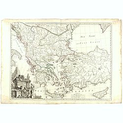
Turquie d'Europe..
Detailed map encompassing present day Greece and part of Turkey. In the lower right corner a large depiction of Cyprus. With ornamental title cartouche and noteworthy top...
Date: Venice, 1776 - 1784
Selling price: ????
Please login to see price!
Sold in 2018
Royaume de Hongrie divisee dans ces cercles. . .
Detailed map encompassing present day Hungary with the river Danube and the towns of Belgrade, Budapest, Vienna, etc.From "Atlas Universel" published by Santini...
Date: Venice, 1776 - 1784
Selling price: ????
Please login to see price!
Sold in 2015
Royaume d'Esclavonie et du Duché De Syrmie..
Detailed map encompassing show us Danube and to the right Belgrade.From "Atlas Universel" published by Santini in 1776-84. The atlas is effectively an Italian c...
Date: Venice, 1776 - 1784
Selling price: ????
Please login to see price!
Sold in 2015
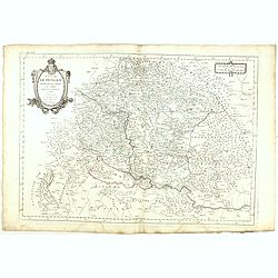
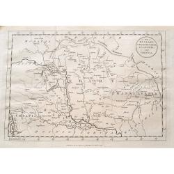
Principauté de Transilvanie et Pays circonvoisins. . .
Detailed map encompassing part of present-day Hungary.With ornamental title cartouche and noteworthy topographical detail.The map was prepared by the Venetian cartographe...
Date: Venice, 1784
Selling price: ????
Please login to see price!
Sold in 2022
Royaume de Hongrie divisee dans ces cercles. . .
Detailed map encompassing present day Hungary with the river Danube and the towns of Belgrade, Budapest, Vienna, etc.Venetian edition of the map by R. de Vaugondy, to who...
Date: Venice, 1776 - 1784
Selling price: ????
Please login to see price!
Sold in 2015
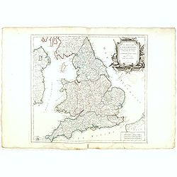
Le royaume d'Angleterre..subdivisé en Shires ou Comtés.
Finely and crisply engraved map of British Isles including the coasts of France and Ireland.Venetian edition of Giles Didier Robert De Vaugondy's map from Atlas Universel...
Date: Venice, 1778 - 1784
Selling price: ????
Please login to see price!
Sold in 2023
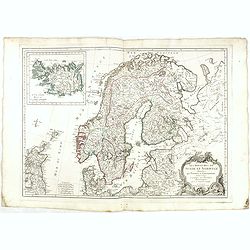
Les Royaumes de Suede et Norwege divisés par Provinces et Gouvernements Dressés et assujettis aux observations Astronomiques. Par le Sr. Janvier Géographe.
Detailed map of Scandinavia and covering Sweden, Norway, Denmark, Finland and Livonia with a section of Poland and Prussia.The coastlines are well-drawn to illustrate the...
Date: Venice, 1784
Selling price: ????
Please login to see price!
Sold in 2017
Cercle de Souabe.. les enclaves de la Maison d'Autriche.
Finely and crisply engraved map of western part of Austria.Venetian edition of Giles Didier Robert De Vaugondy's map from Atlas Universel printed in 1776-84.Ornamental ti...
Date: Venice, 1776 - 1784
Selling price: ????
Please login to see price!
Sold in 2016
Le Tyrol sous le nom duquel l'on comprend Le comté de Tyrol. . .
Finely and crisply engraved map of Tyrol centered on Innsbruck .br />With ornamental title cartouche and noteworthy topographical detail.The map was prepared by the Ve...
Date: Venice, 1778 - 1784
Selling price: ????
Please login to see price!
Sold in 2015

Partie septentrionale des Pays-Bas comprenant .. des provinces unies
Finely and crisply engraved map of Netherlands.Venetian edition of Giles Didier Robert De Vaugondy's map from Atlas Universel printed in 1784.Ornamental title cartouche i...
Date: Venice, 1776 - 1784
Selling price: ????
Please login to see price!
Sold in 2015
Partie saptentrionale du cercle de Haute Saxe.. Brandebourg.
Finely and crisply engraved map of north eastern part of Germany, including inset map of Brandenburg.Venetian edition of Giles Didier Robert De Vaugondy's map from Atlas ...
Date: Venice, 1776 - 1784
Selling price: ????
Please login to see price!
Sold in 2015
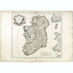
Royaume d'Irelande.. et subdivisé en Comtés.
Finely and crisply engraved map of Ireland. With ornamental title cartouche and noteworthy topographical detail.The map was prepared by the Venetian cartographer and publ...
Date: Venice, 1776 - 1784
Selling price: ????
Please login to see price!
Sold in 2022
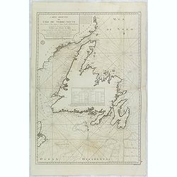
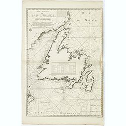
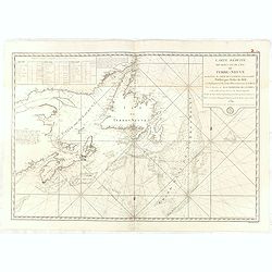
Carte Reduite de l'Ile de Terre-Neuve . . .
Fine large sea of Terre Neuve. Relief shown by hachures. Depths shown by soundings. Below engraved seal of Depot General de la Marine. Prepared under the direction of de...
Date: Paris, 1784
Selling price: ????
Please login to see price!
Sold in 2015
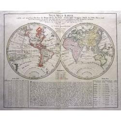
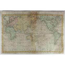
Neue Welt=Karte Welche auf zwoo Kugelflaechen die Haupt=Theile der Erde...
Double hemisphere map of the world which includes the tracks of Goree's voyage in 1780, Clerke's Voyage in 1779 and Cook's voyage in 1777-78. An early map to already show...
Date: Nuremberg, 1784
Selling price: ????
Please login to see price!
Sold in 2015
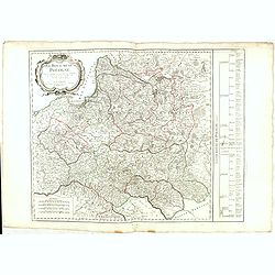
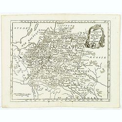
Royaume de Pologne.
Detailed map encompassing present-day Poland. The table provides a breakdown of the sub-regions of the Polish Crown.Venetian edition of the map by R. de Vaugondy, to whom...
Date: Venice, 1776 - 1784
Selling price: ????
Please login to see price!
Sold in 2016
La Crimée, la nouvelle Russie, les Tatares Nugay et d'Oczakow...
Engraved by Perrier, Bourgoin and Arrivet. The map was prepared by the Venetian cartographer and publisher François (Père) Santini and first published in Santini's &quo...
Date: Venice, 1784
Selling price: ????
Please login to see price!
Sold in 2015
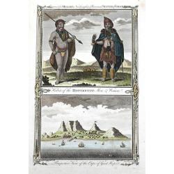
Habits of the Hottentot Men & Women. / Perspective view of the Cape of Good Hope.
Two fine views on one sheet. On top the view shows a native couple with their traditional clothing. The bottom view features the Cape of Good Hope, several houses and sai...
Date: London, 1784
Selling price: ????
Please login to see price!
Sold in 2016
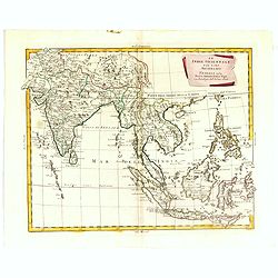
Le Indie Orientali E Il Loro Arcipelago . . .
Striking map of the region from the Gulf of Bengal to Hainan, centered on the Malay Peninsula, Straits of Malacca, Sumatra, Java and Philippines.The map was issued in Zat...
Date: Venise, 1784
Selling price: ????
Please login to see price!
Sold in 2018
Carte de la partie septentrionale de l'empire Otoman. contenant la Crimée, la Moldavie, la Valakie, la Bulgarie, avec la nouvelle Russie, les gouvernement d'Astracan, et de Voronez...
Carte de la partie septentrionale de l'empire Otoman. contenant la Crimée, la Moldavie, la Valakie, la Bulgarie, avec la nouvelle Russie, les gouvernement d'Astracan, et...
Date: Venice, 1784
Selling price: ????
Please login to see price!
Sold in 2018
A map of Hungary, Transilvania, Sclavonia, and Croatia.
Unusual map of Eastern Europe, from Vienna and the Gulf of Venise to the border of Moldova and the Carpathian Mountains. Includes the Balaton lake, Bratislava, Belgrade, ...
Date: London, 1784
Selling price: ????
Please login to see price!
Sold in 2016
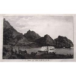
A view of Huaheine.
Detailed view of Cook's landing at Huahine Island in French Polynesia. Shows numerous people and canoes greeting the two sailing ships Resolution & Discovery. A large...
Date: London, ca. 1784
Selling price: ????
Please login to see price!
Sold in 2016

Carte Réduite du Golphe de Gascogne. . .
Uncommon chart of the coast of Gascoigne from Brest in Brittany up to Santander in Spain.
Date: Paris, 1756 - 1784
Selling price: ????
Please login to see price!
Sold in 2018
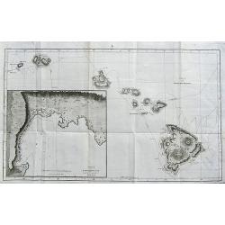
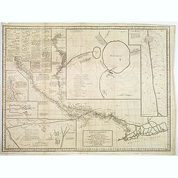
Chart of the Sandwich Islands.
A large chart showing the tracks of Captain James Cook through the Hawaiian islands. Names Owyhee, Mowee, Morotoi, Ranai, Woahoo, Atooi and Oneeheow. Large inset of Karak...
Date: Dublin, ca 1784
Selling price: ????
Please login to see price!
Sold in 2020

(Frontispiece to Walpoole's New & Complete British Traveller.)
Interesting title page showing a globe and a map. Below with text: "This Superbly Elegant Frontispiece Represents Britannia (attended by Prudence, Justice, Temperanc...
Date: London, 1784
Selling price: ????
Please login to see price!
Sold in 2017
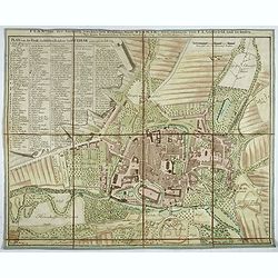
Plan von der fürstlich. sæchsischen Residenz Stadt Weimar. Nürnberg, Homænnischen Erben, 1784.
Very rare town-plan of Weimar, capital of the Duchy of Saxe-Weimar, prepared in 1782 by Franz Ludwig Güssefeld, German engineer and cartographer.In the left part a key (...
Date: Nuremberg, 1784
Selling price: ????
Please login to see price!
Sold in 2018
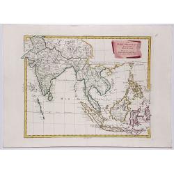
LE INDIE ORIENTALI E IL LORO ARCIPELAGO.
A striking regional map, extending from the Phillipines and Moluccas to India and the Maldives, and north to Tibet. Decorative scroll title cartouche.From Zatta's monumen...
Date: Venise, 1784
Selling price: ????
Please login to see price!
Sold in 2017
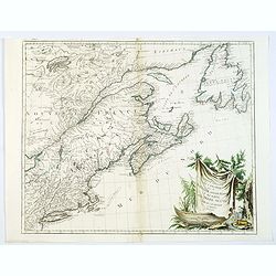
Partie Orientale du Canada avec la Nouvelle Angleterre. . .
A fine map of the extremities of Canada after d'Anville's work, to whom Santini gives credit in the cartouche.The map extends from New York northwards to include Lake Mis...
Date: Venice, 1776 - 1784
Selling price: ????
Please login to see price!
Sold in 2019
A New General Chart: Exhibiting the Discoveries Made by Capt'n James Cook in His First, Second and Third Voyages...
An important map featuring the three voyages of Captain Cook and including the tracks of these voyages including place names, dates and notes. Interestingly but appropria...
Date: London, 1784
Selling price: ????
Please login to see price!
Sold in 2017
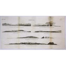
Sandwich Islands.
A copperplate engraving from the accounts of Cook’s third and final voyage. It features coastal profile views of the Hawaiian Islands, where Cook arrived in 1778. It in...
Date: London, 1784
Selling price: ????
Please login to see price!
Sold in 2017
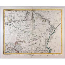
Partie des Gouvernemens d'Astracan et de Woronez le Kabarda et Partei du Pais des Coszques du Don et du Jaik
A detailed pleasing map of Astrakhan Voronezh, the region north of the Black Sea and west of the Caspian Sea. One of the most detailed maps of the region to appear in a c...
Date: Venice, 1784
Selling price: ????
Please login to see price!
Sold in 2023
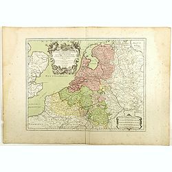
Les Dix-Sept Provinces des Pays-Bas. . .
Map of the present-day Benelux by L.C. Desnos.
Date: Paris, 1784
Selling price: ????
Please login to see price!
Sold in 2018
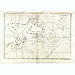
Carte réduite de l'Ile de Terre-Neuve..
Revolutionary war sea of New Foundland .Relief shown by hachures. Depths shown by soundings. Below engraved seal of Depot General de la Marine. Prepared under the direct...
Date: Paris, 1784
Selling price: ????
Please login to see price!
Sold in 2018
Carte réduite des Bancs et de l'Ile de Terre-Neuve..
Revolutionary war sea of New Foundland.Relief shown by hachures. Depths shown by soundings. Below engraved seal of Depot General de la Marine. Prepared under the directi...
Date: Paris, 1784
Selling price: ????
Please login to see price!
Sold in 2018
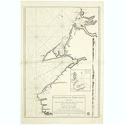
Plan des Côtes de Terre-Neuve, IV ème Feuille..
Revolutionary war sea of New Foundland.Relief shown by hachures. Depths shown by soundings. Below engraved seal of Depot General de la Marine. Prepared under the directi...
Date: Paris, 1784
Selling price: ????
Please login to see price!
Sold in 2018
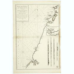
Plan des Côtes de Terre-Neuve, V ème Feuille..
Revolutionary war sea of New Foundland.Relief shown by hachures. Depths shown by soundings. Below engraved seal of Depot General de la Marine. Prepared under the directi...
Date: Paris, 1784
Selling price: ????
Please login to see price!
Sold in 2018
Carte réduite des Bancs et de l'Ile de Terre-Neuve..
Revolutionary war sea of New Foundland .Relief shown by hachures. Depths shown by soundings. Below engraved seal of Depot General de la Marine. Prepared under the direct...
Date: Paris, 1784
Selling price: ????
Please login to see price!
Sold in 2018
![L'Anse a Chouchou [with] Le Port Paix [with] Mouillage de Jean- Rabel [with] La Baye Moustique [with] Baye de Tiburon [with] Baye des Gonayves [with] La Baye du Fond de la Grange [with] Port a l'Écu [with] rade de la Basse-Terre. ( 9 plans).](/uploads/cache/36433-250x250.jpg)
L'Anse a Chouchou [with] Le Port Paix [with] Mouillage de Jean- Rabel [with] La Baye Moustique [with] Baye de Tiburon [with] Baye des Gonayves [with] La Baye du Fond de la Grange [with] Port a l'Écu [with] rade de la Basse-Terre. ( 9 plans).
Nine revolutionary war sea on one sheet, showing various bays and harbors on Hispaniola and Tortuga. Engraved by Dela Haye for the Depot de la Marine. Each section shows...
Date: Paris, 1784
Selling price: ????
Please login to see price!
Sold in 2020
Carte Generale du Cours du Gange et du Gagra. . .
A large chart with six inset maps printed on one sheet by the Jesuit Joseph Tiefentaller in the latter half of the eighteenth century. The map is in French and in Persian...
Date: Paris ca 1784
Selling price: ????
Please login to see price!
Sold in 2023
![[2 maps] Partie Septentrionale... & Partie Meridionale du Royaume de Portugal...](/uploads/cache/81817-250x250.jpg)
[2 maps] Partie Septentrionale... & Partie Meridionale du Royaume de Portugal...
A pair of large maps of Portugal with bordering Spanish areas. From Fisterra, Vigo and Pontevedra until Cadiz. Extends east until Salamanca and Sevilla. Very detailed, fi...
Date: Venice, 1784
Selling price: ????
Please login to see price!
Sold in 2018
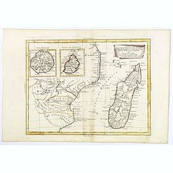
Parte della Costa a Orientale dell'Africa con I'Isola di Madagascar e le Carte particolari dell'Isole di Francia e di Borbon.
An uncommon map of Madagascar with inset maps of the islands of Bourbon and Francia. Mauritius. Embellished with a nice 'scroll' title-cartouche.
Date: Venice, 1784
Selling price: ????
Please login to see price!
Sold in 2018
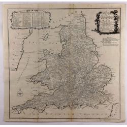
A New most Accurate & Complete Map of All the Direct and the Principal Cross Roads in England and Wales.
A fine double page map of England and Wales delineating all the major roads by Thomas Kitchin for Walpoole's "New and Complete British Traveller". Features incl...
Date: Leipzeg, 1784
Selling price: ????
Please login to see price!
Sold in 2018
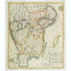
A Map of the Southern Provinces of Sweden.
An attractive map of the southern most provinces of Sweden, published by T. Cadell for Thomas Kitchin, 'Hydrographer to his Majesty' (King George III). Map extends from b...
Date: London, ca 1784
Selling price: ????
Please login to see price!
Sold in 2020

A View of the Principal Place & Manner of Execution of Persons condemned by the Inquisition of Spain.
Early 18th century engraving. Engraved for the Rev Dr Wright's Modernised and Improved Edition of Fox's original Book of Martyr's. Inscription: London Published by Alexan...
Date: London, 1784
Selling price: ????
Please login to see price!
Sold in 2018
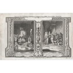
Cruel Methods by which Mr Nicholas Burton an Englishman was Tortured in the Inquisitorial Prison at cadiz in Spain . . .
Early 18th century engraving. Engraved for the Rev Dr Wright's Modernised and Improved Edition of Fox's original Book of Martyr's. Inscription: London, Published by Alexa...
Date: London, 1784
Selling price: ????
Please login to see price!
Sold in 2018
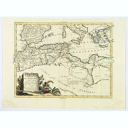
Le Coste di Barbaria. . .
An delightfully engraved map of the North African Barbary Coast, embellished with an colored pictorial title cartouche, published in Venice by Antonio Zatta towards the e...
Date: Venice, 1784
Selling price: ????
Please login to see price!
Sold in 2019
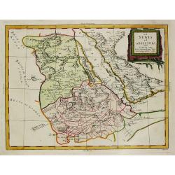
La Nubia et Abissinia.
An antique map of East Africa: La Nubia et Abissinia by Antonio Zatta, (fl. 1757-1797). Zatta was a Venetian publisher. Published in his atlas of 4 volumes 'Atlante novis...
Date: Venice, 1784
Selling price: ????
Please login to see price!
Sold in 2019
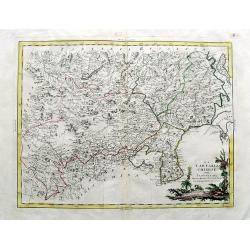
LA TARTARIA CHINESE.
An attractive copper engraved map of the Far East covering parts of China, South Korea, Mongolia, Russia and Japan (Jeso-Gasima). Includes the Chinese Wall, the Gobi dese...
Date: Venice, 1784
Selling price: ????
Please login to see price!
Sold in 2019
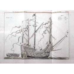
The Ship Harry Grace a Dieu, from an Original Drawing preserved in the Pepysian Library in Magdalen College Cambridge.
Scarce copper-engraved illustration of the ship with fine detail. Henry Grace à Dieu also known as Great Harry, was an English carrack or "great ship" of the K...
Date: London, 1784
Selling price: ????
Please login to see price!
Sold in 2020
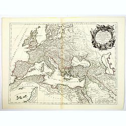
Romani Imperii occidentis . . . Tabula Geographica. . .
Finely and crisply engraved map of the Roman Empire centered on Italy and Greece.Showing the Mediterranean basin together with its hinterland in Africa and Asia. Inset ma...
Date: Venice, 1776 - 1784
Selling price: ????
Please login to see price!
Sold in 2021
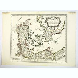
Royaume de Danemarck. qui comprend le Nort-Jutland . . . Sélande, Laland.
A fine and crisp engraved map of Denmark. This is from the Venetian edition of Giles Didier Robert De Vaugondy's map from Atlas Universel printed in 1776-84.With a lovely...
Date: Venice, 1776 - 1784
Selling price: ????
Please login to see price!
Sold in 2020
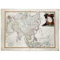
L' ASIE divisee en ses principaux ETATS.
A detailed map of Asia from Janvier's 'Atlas Moderne'. Original coloring and new coloring on the decorative cartouche.
Date: Paris, 1784
Selling price: ????
Please login to see price!
Sold in 2019
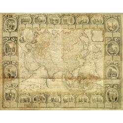
Carte D'Asie Divisée en ses Principaux Etats. . .
Uncommon and decorative carte à figures wall map, prepared by Cloued, with superb decoration. The map is interesting as it shows Korea in the d'Anville type with labelin...
Date: Paris, 1785
Selling price: ????
Please login to see price!
Sold
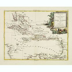
Stabilimenti de Francesi, Inglesi, E Spagnuoli nelle Isole Antille. . .
Uncommon map of Caribbean, including Florida, Bahamas and coast of Venezuela, including Curacao, Artiba I, Buenayre , etc. Engraved by G.Pitteri.
Date: Venice, 1785
Selling price: ????
Please login to see price!
Sold in 2022
Carte Générale de la Pologne. . .
Map of Poland, from Atlas moderne portatif composé de vingt-huit cartes sur toutes les parties du globe terrestre .. A l'usage des Colléges, des Pensions & des Mais...
Date: Paris, 1785
Selling price: ????
Please login to see price!
Sold in 2013
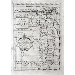
A Map of Ancient AEGYPT from Celarius.
A Map of Ancient Egypt from Celarius, by Thomas Stackhouse, from "Universal Atlas".A map of ancient Egypt showing the cities, pyramids and topography. As state...
Date: London, 1785
Selling price: ????
Please login to see price!
Sold in 2012
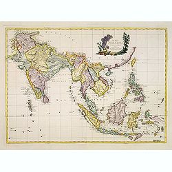
Indie Orientali di Quà e di la Dal Gange col Loro Arcipelago.
Fine almost wall sized map of South east Asia, including Formosa, New Guinea, the Maldives and the Indus delta. From his "Atlante Novissimo, illustrato ed accresciut...
Date: Venice, ca. 1779 - 1785
Selling price: ????
Please login to see price!
Sold in 2013
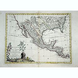
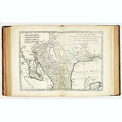
Messico ouvero Nuova Spagna che contiene Il Nuova Messico La California con una Parte de Paesi Adjacenti. . .
Decorative and detailed map of the southern part of the United States, Mexico and Central America. The map is filled with remarkable detail throughout, particularly in Te...
Date: Venise, 1785
Selling price: ????
Please login to see price!
Sold in 2014
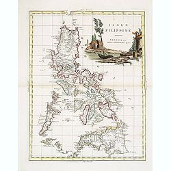
Isole Filippine.
One of the most decorative and sought after separate maps of the Philippines, based on the very rare map of Velarde. Covers all of the islands with remarkable detail. Dec...
Date: Venise, 1785
Selling price: ????
Please login to see price!
Sold in 2013
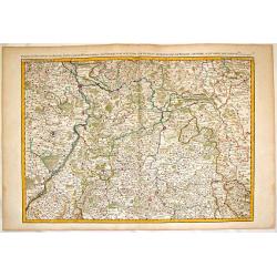
Partie du Palatinat du Rhein, le Duché de Wirtenberg les Partie du Palatinat du Rhein. Le Duche de Wirtenberg, Les Marquisats de Bade & Durlac, les Eveschés de Worms de Spire et le Comté de Linange.
Large, hand-colored, copperplate map of Rhineland Germany. It features the cities of Manheim, Hailbron, Stuttgart, Heidelberg & Baden. very detailed showing individua...
Date: Paris, 1785
Selling price: ????
Please login to see price!
Sold in 2016
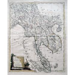
Regni D'Aracan Del Pegu Di Siam Di Camboge E Di Laos.
Fantastic copper engraved map of Burma, Thailand, Cambodia, Vietnam, Hainan, Straits of Malaca, the Malay Peninsula, and parts of Sumatra. Also with the Andaman, Nicobar,...
Date: Venice, 1785
Selling price: ????
Please login to see price!
Sold in 2013
Atlas de Toutes les Parties Connues du Globe Terrestre, dressé pour l'Histoire Philosophique & Politique des Etablissemens & du Commerce des Européens dans les deux Indes.
Illustrated with 49 fine uncolored copper plate maps. All maps have centerfold, except for plate I ("L'Ancien Monde et le Nouveau en Deux Hemispheres") which ha...
Date: Geneve, J.L. Pellet, 1785
Selling price: ????
Please login to see price!
Sold