Browse Listings
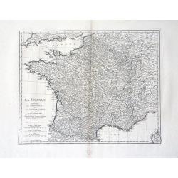
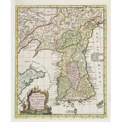
La France Divisee en Provinces et en Generalites Dont le plan est selui de l'ancienne Gaule. . .
A beautiful, large scale, highly detailed, 18th century map of France modeled on a plan of ancient Gaul by Jean Baptiste Bourguignon D'Anville, with major boundaries colo...
Date: Paris, 1780
Selling price: ????
Please login to see price!
Sold in 2010
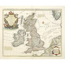
Magnae Britanniae Tabula, comprehendens Angliae, Scotiae ac Hiberniae.
The 1702 Delisle general map of the British Isles, copied by Pierre Mortier in 1702 and here in a second state with the address of Jean Covens and Cornelis Mortier.The Am...
Date: Amsterdam, ca. 1780
Selling price: ????
Please login to see price!
Sold in 2010
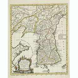
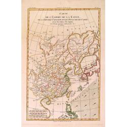
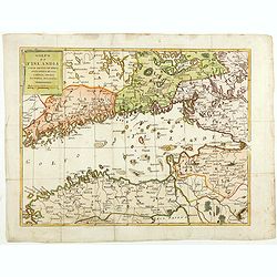
A map of Quan-Tong or Lea-Tonge province, and the kingdom of Kau-Li or Corea . . .
Detailed map of Korea, Liaodong, and the tip of Shandong Province prepared by Thomas Kitchin for Thomas Salmon's Universal Traveller, based on D'Anville's landmark map of...
Date: London, 1780
Selling price: ????
Please login to see price!
Sold
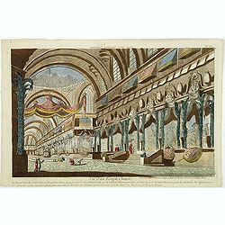
Vue d'un Temple Chinois.
So called optical print showing the interior of a Chinese temple. In the eighteenth and nineteenth centuries there were many popular specialty establishments in Paris, Au...
Date: Paris, 1780
Selling price: ????
Please login to see price!
Sold in 2017
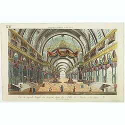
Vue du superbe Temple du Serpent dans la Ville de Juida a la Chine.
Uncommon, so-called optical print of a imaginary interior of a Chinese temple, decorated with vases and two large Buddha's in the center. In the eighteenth and nineteenth...
Date: Paris, 1780
Selling price: ????
Please login to see price!
Sold in 2017
![[Title page] Géographie moderne avec une introduction. . .](/uploads/cache/31048-250x250.jpg)
[Title page] Géographie moderne avec une introduction. . .
Engraved title page from Jean Baptiste Louis Clouet (1730-1790) influential "Géographie Moderne" first published in 1767 and reissued in several editions well ...
Date: Paris, 1780
Selling price: ????
Please login to see price!
Sold in 2011
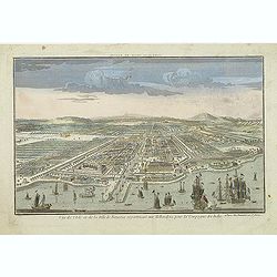
Vue de l\'Isle et de la ville Batavia appartenant aux Hollandois. . .
So called optical print of present-day Jakarta. Published by the well-known Paris publisher Daumont after a design of Jan van Ryne in 1754. Van Ryne was born in the Nethe...
Date: Paris, c.1780
Selling price: ????
Please login to see price!
Sold in 2011
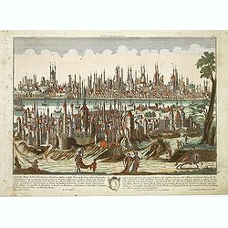
Constantinopolis.
Beautiful optical printof Constantinople, the capital of the Ottoman Empire between 1453 and 1922. It was officially renamed to its modern Turkish name Istanbul in 1930, ...
Date: Augsburg, 1780
Selling price: ????
Please login to see price!
Sold in 2011
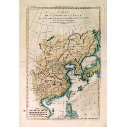
A map of Quan-Tong or Lea-Tonge province, and the kingdom of Kau-Li or Corea . . .
Detailed map of Korea, Liaodong, and the tip of Shandong Province prepared by Thomas Kitchin for Thomas Salmon's Universal Traveler, based on D'Anville's landmark map of ...
Date: London, 1780
Selling price: ????
Please login to see price!
Sold
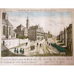
![[Prospect der Strasse gegen der Kirche der Recolecten in der obern Stadt zu Quebec. Vuë de la Rue des Recolets dans la haute Ville de Quebec ]](/uploads/cache/31160-250x250.jpg)
[Prospect der Strasse gegen der Kirche der Recolecten in der obern Stadt zu Quebec. Vuë de la Rue des Recolets dans la haute Ville de Quebec ]
A so-called optical print showing a decorative imaginary of Québec, with a street view with soldiers marching, and pedestrians, an idealized view depicting Québec as a...
Date: Augsburg, ca. 1780
Selling price: ????
Please login to see price!
Sold in 2011
![[Prospect des Haupt Plazes der Untern Stadt zu Quebec. ]](/uploads/cache/31161-250x250.jpg)
[Prospect des Haupt Plazes der Untern Stadt zu Quebec. ]
A so-called optical print showing a decorative imaginary town-view of Québec, with a street view with soldiers marching, and pedestrians, an idealized view depicting Qu�...
Date: Augsburg, ca.1780
Selling price: ????
Please login to see price!
Sold in 2011
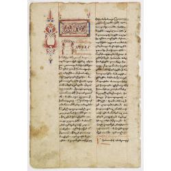
Large paper leaf from an Armenian prayer(?)-book in manuscript.
Large paper leaf from an Armenian prayer(?)-book in manuscript on heavy shiny paper.32 lines of text in black ink, partly in red ink, in a Bolorgir hand. RECTO: Large hea...
Date: Armenia, c.1750 - 1780
Selling price: ????
Please login to see price!
Sold in 2012
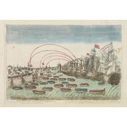
Vue de la prise des forts et ville de havane par les Anglois en 1762.
So-called optical print illustrating a perspective view of the siege of Havana by the English troops in 1762.Mondhare, active at rue St.Jacques a l'Hotel Saumur, was a we...
Date: Paris, c.1780
Selling price: ????
Please login to see price!
Sold in 2016

J.Anckerstöm a killer of King Gustave III.
Uncommon and decorative aquatint full length portrait of J.Anckerstöm. This aquatint by T.C. Lotter was made after a design of Witterquits.Gustav III (1746 – 1792) was...
Date: Augsburg, 1780
Selling price: ????
Please login to see price!
Sold in 2014
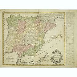
Los reynos de España y Portugal, según las últimas y nuevas observaciones de las Academias de Paris y de Londres.
Very rare, likely separately issued map of Spain and Portugal with text in Spanish. Based on a map by William Faden from London.
Date: Spain or London, c.1780
Selling price: ????
Please login to see price!
Sold in 2023
![[Title page] Géographie moderne avec une introduction. . .](/uploads/cache/32039-250x250.jpg)
[Title page] Géographie moderne avec une introduction. . .
Engraved title page from Jean Baptiste Louis Clouet (1730-1790) influential "Géographie Moderne" first published in 1767 and reissued in several editions well ...
Date: Paris, 1780
Selling price: ????
Please login to see price!
Sold in 2012
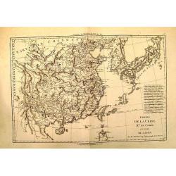
Empire de la Chine, Rme. de Coree, ad Isles Du Japon
Attractive map of China that includes an impressive 11 different scales.
Date: Paris, c. 1780
Selling price: ????
Please login to see price!
Sold
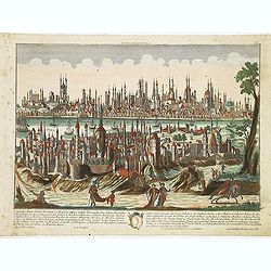
Constantinopolis.
Beautiful optical printof Constantinople, the capital of the Ottoman Empire between 1453 and 1922. It was officially renamed to its modern Turkish name Istanbul in 1930, ...
Date: Augsburg, 1780
Selling price: ????
Please login to see price!
Sold in 2012
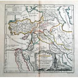
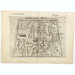
CARTE DES PREMIERS AGES DU MONDE
Beautiful ancient map, showing the eastern Mediterranean and the Near East. Includes parts of the present countries of Cyprus, Turkey, Russia, Black Sea, Caspian Sea, Arm...
Date: Paris, 1780
Selling price: ????
Please login to see price!
Sold in 2014
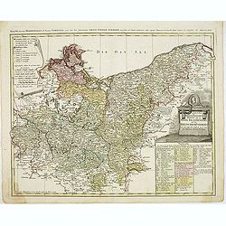
Der Nordliche Theil des Obersachsischen Kreises oder die Mark Brandenburg und das Herzogthum Pommern
Detailed map of Northern Germany, including Pomerania, Rugen, Brandenburg, etc. Centered on Berlin and the Oder River, it shows towns, roads, rivers, lakes, mountains, is...
Date: Nuremberg, 1780
Selling price: ????
Please login to see price!
Sold in 2012

Double page manuscript page with Islamic prayers with beautiful headings throughout.
Fine double page brilliantly illuminated gilt leaves written by the scribe Abu Bakr Jami in Isfahan. The Arabic text contains Islamic prayers with beautiful headings thro...
Date: Isfahan, ca. 1780
Selling price: ????
Please login to see price!
Sold in 2016
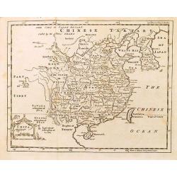
China.
Decorative map by the noted English cartographer Thomas Jeffreys, Geographer to George III and the Prince of Wales.
Date: London, c. 1780
Selling price: ????
Please login to see price!
Sold in 2012
Carte de L'Empire de la Chine. . .
Nice copper-engraved map of China, Korea and Japan. Most of the topographical detail is limited to China. Small arrows indicate the trade winds. The map bears four distan...
Date: Paris, c. 1780
Selling price: ????
Please login to see price!
Sold in 2012
Carte de L'Empire de la Chine . . .
Nice copper-engraved map of China, Korea and Japan. Most of the topographical detail is limited to China. Small arrows indicate the trade winds. The map bears four distan...
Date: Paris, c. 1780
Selling price: ????
Please login to see price!
Sold in 2013
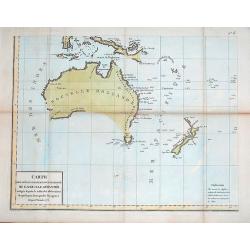
Carte des declinaisons et inclinaisons de L'aiguille aimantee redigee d'apres la table des observations magnetiques faites par les voyageurs depuis l'annee 1775
Map of Australasia with imaginary line joining coastline of Australia and New Guinea.Plate No. 6 of an 8 sheet map which was probably compiled from the reports of La Pero...
Date: Paris, ca. 1780
Selling price: ????
Please login to see price!
Sold in 2012
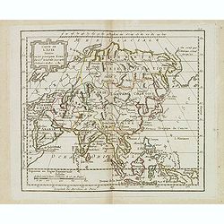
Carte de l'Asie. . .
Scarce map of Asia prepared by de la Fosse and published by L.J. Mondhare for his Atlas Général a l'usage des colleges et maisons d'education.. Louis Joseph Mondhare wa...
Date: Paris, 1780
Selling price: ????
Please login to see price!
Sold in 2016
A View of the Royal Exchange , London. Vue de la bourse royal a Londres. . .
So-called optical print of London with a view of Cornhill and the Exchange, with St. Paul's visible in the distance - horse-drawn traffic laboring along the road.The imag...
Date: Paris, ca. 1780
Selling price: ????
Please login to see price!
Sold in 2023
![Fille tatare de Katchin par devant. [together with] Fille tatare de Katchin par derriere.](/uploads/cache/32992-250x250.jpg)
Fille tatare de Katchin par devant. [together with] Fille tatare de Katchin par derriere.
Uncommon copper engraved costume plate from Johann Gottlieb Georgi "Beschreibung aller Nationen des russischen Reichs" (1776), the work stands out for the hand-...
Date: St. Petersbourg, C.G. Müller, 1776-1780
Selling price: ????
Please login to see price!
Sold in 2020
![Feme Tattare de Casan par devant. [together with] Feme Tattare de Casan par derriere.](/uploads/cache/32994-250x250.jpg)
Feme Tattare de Casan par devant. [together with] Feme Tattare de Casan par derriere.
Uncommon copper engraved costume plate from Johann Gottlieb Georgi "Beschreibung aller Nationen des russischen Reichs" (1776), the work stands out for the hand-...
Date: St. Petersbourg, C.G. Müller, 1776-1780
Selling price: ????
Please login to see price!
Sold in 2013

Hotel des Monnoies, Projete sur le Terrein de l'Hotel de Conty
Very large copper engraving featuring a view of the Hotel de Monnaies, a C-shaped mansion with steps outside the courtyard. The engraver was Claude Rene Gabriel Poulleau ...
Date: Paris, c1780
Selling price: ????
Please login to see price!
Sold in 2020
Carte de Moscovie.
Important,very large map of the Russian Empire in Europe. The copper engraved map covers present-day Russia, Lithuania, Estonia, Poland, Lapland, Lavia and part of Scandi...
Date: Paris, 1780
Selling price: ????
Please login to see price!
Sold in 2016
Carte du Perou avec Une Partie des Pays Qui en Sont a L'Est
An interesting map of Peru with the "Country of Amazon" on it Eastern border. From "Atlas de Toutes les Parties Connues du Globe Terrestre". Detailed ...
Date: Paris, 1780
Selling price: ????
Please login to see price!
Sold in 2014
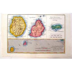
Cartes Particulieres des Isles de France, de Bourbon et de Rodrique.
An interesting map of islands east of Madagascar. From "Atlas de Toutes les Parties Connues du Globe Terrestre". Detailed with rivers, lakes, cities and mountai...
Date: Paris - 1780
Selling price: ????
Please login to see price!
Sold in 2013
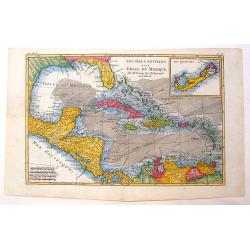
Les Isles Antilles et le Golfe du Mexique.
A beautiful colored map of the Gulf of Mexico with an inset map of Bermuda Island. From "Atlas de Toutes les Parties Connues du Globe Terrestre". Detailed with ...
Date: Paris - 1780
Selling price: ????
Please login to see price!
Sold in 2013
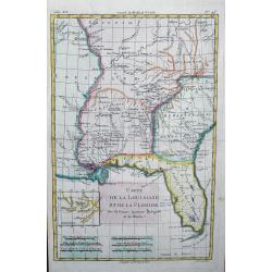
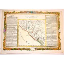
Carte de la Louisiane et de la Floride
Interesting map of the Southeast and the Mississippi River Valley. The map extends from Charleston, South Carolina west to include New Orleans and north well into Illinoi...
Date: Paris, c1780
Selling price: ????
Please login to see price!
Sold in 2013
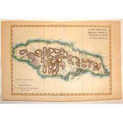
Carte de L'Isle de la Jamaique.
Hand-colored, copper plate map of the island of Jamaica in the Caribbean. Detailed presentation of the settlements, ports and forts. BONNE, RIGOBERT (1729-1795). Bonne w...
Date: Paris, 1780
Selling price: ????
Please login to see price!
Sold in 2013
Carte des Decouvertes du Capital Carteret dans La Nouvelle bretagne.
Detailed copperplate map of Papua New Guinea and the regions to the west including New Ireland, Sable Banks, the Celebes and Southern Mindanao. BONNE, RIGOBERT (1729-179...
Date: Paris, 1780
Selling price: ????
Please login to see price!
Sold in 2015
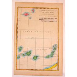
Carte des Isles Canaries.
Fine copper engraved map of The Canary Islands including Madiera & Porto Santo Islands. BONNE, RIGOBERT (1729-1795). Bonne was “Royal Hydrographer” and his princ...
Date: Paris, 1780
Selling price: ????
Please login to see price!
Sold in 2015
Suite de L'Histoire de Rome, Depuis L'An 3565 Jusqu'a l'An 3591.
Pleasant hand-colored copper engraved map of ancient Rome. With lovely floral ribboned border, engraved separately. Text in French. Louis Charles Desnos (1725-1805) was ...
Date: Paris, 1780
Selling price: ????
Please login to see price!
Sold in 2015
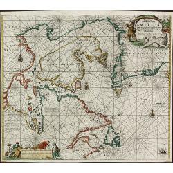
Pascaarte vande Noorder Zee Custen van America, vande West-Hoeck van Ysland doorde Straet Davis en Hudson, tot aen Terra Neuf
Fourth and last edition of van Keulen's chart of the Arctic Canada with the Hudson Bay and the supposed Northwest Passage. First published in 1680. The map is based upon ...
Date: Amsterdam, 1780
Selling price: ????
Please login to see price!
Sold in 2013
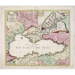
Nova Mappa Maris Nigri et Freti Constantino Politani. . .
Decorative and uncommon map the Black Sea region. In upper left hand corner an inset map (200x280) of the Bosporus including Istanbul. Title engraved onto a drape-style c...
Date: Augsburg, 1780
Selling price: ????
Please login to see price!
Sold in 2015
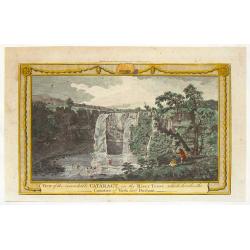
View of the Remarkable Cataract on the River Teese, Which Divides the Counties of York and Durham.
Fine hand-colored, copper engraved print of an inviting view of a waterfall being viewed by two spectators and two fishermen. The print was engraved for "The Complet...
Date: London, c. 1780
Selling price: ????
Please login to see price!
Sold in 2015
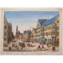
Vue Perspective de la Rue des Peintres du Cote Inferieur Vers la Tour de Perlac à Augsbourg.
A striking copper engraved print of the streets of Augsbourg, printed in Paris by Jacques Chereau. "Vue’D’Optique" optical view prints are views used in a ...
Date: Paris, 1780
Selling price: ????
Please login to see price!
Sold in 2013
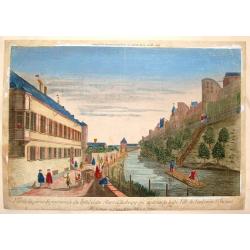
Vue de la Partie Septentrionale du Fosse et des Murs D'Ausbourg Qui Separent la Basse Ville du Faubourg St. Jacques.
A striking copper engraved print of the river separating Augsburg, Germany from Faubourg, printed in Paris by Basset."Vue’D’Optique" optical view prints are...
Date: Paris, 1780
Selling price: ????
Please login to see price!
Sold in 2016
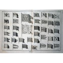
Marine.
Curious double-page copper-engraved display of 38 detailed maritime flags. Engraved by Pietro Scattaglia, probably for Denis Diderot.
Date: Paris, c1780
Selling price: ????
Please login to see price!
Sold in 2013
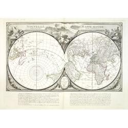
Mappemonde ou Description du Globe. . .
Attractive large double hemisphere map based on the Janvier map of the same title, but with different decorations. The map depicts several routes of exploration up to the...
Date: Venice, 1780
Selling price: ????
Please login to see price!
Sold in 2013
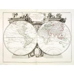
Nouvelle Mappe Monde dediee au progres de nos connoissances.
A handsome and well engraved world map constructed with the prime meridian through Paris. The hemispheres are rotated through 45 degrees. This is an unusual projection fo...
Date: Venice, 1780
Selling price: ????
Please login to see price!
Sold in 2013
![L\'Amerique divisee en ses principaux Etats . . . [Sea of the West]](/uploads/cache/34033-250x250.jpg)
L\'Amerique divisee en ses principaux Etats . . . [Sea of the West]
America showing massive Seam of the West, Mississippi & tributaries, Colonies, excellent detail in southwest along Rio Grande, and strangely misspelled L.Winnepeg wit...
Date: Venise, 1780
Selling price: ????
Please login to see price!
Sold in 2013
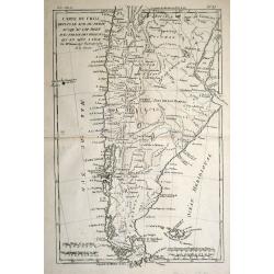
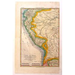
Carte du Chili depuis le Sud du Perou Ju Squ\'au Cap horn avec partie des Regions qui en sont a L\'Est. Par M. Bonne, Ingr. Hydrographe de la Marine.
The decorative map is showing Chili, Patagonia, the Magellan Street and the Falkland Islands.
Date: Paris 1780
Selling price: ????
Please login to see price!
Sold in 2013
Vue de la Rue des Recolets dans la haute Ville de Quebec - Prospect der Strasse, gegen der Kirche der Recolecten in der obern Stadt zu Quebec.
Curious optical print of Quebec, showing a street scene with soldiers and pedestrians. 'In considering the fictitious views of Canada, made up wholly from the imagination...
Date: Augsburg, c1780
Selling price: ????
Please login to see price!
Sold in 2014
'T Gesiaht van 't Binnen Hof Siende na de Zaal en Fransche Kerk Vue du Dedans de la Cour Vers la Sale &. l'Eglise Françoise
Decorative bird's-eye view of 't Binnen Hof in The Hague.In the eighteenth and nineteenth centuries there were many popular speciality establishments in Paris, Augsburg a...
Date: Italy, ca. 1780
Selling price: ????
Please login to see price!
Sold in 2014
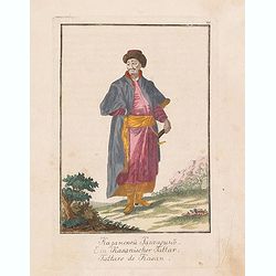
Tattare de Kasan.
Uncommon copper-engraved costume plate from Johann Gottlieb Georgi "Beschreibung aller Nationen des russischen Reichs" (1776), the work stands out for the hand-...
Date: St. Petersbourg, C.G. Müller, 1776-1780
Selling price: ????
Please login to see price!
Sold in 2017
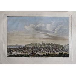
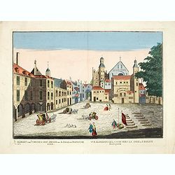
Vue de la Ville de Tobolsk.
Representation of the city Tobolsk in Russia. Engraved by François Denis Nee, after Nicolas Louis de Lespinasse (1737-1808). Published in "Historique physique, mora...
Date: 1780
Selling price: ????
Please login to see price!
Sold in 2014

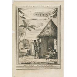
Negres de Kachao et de Bissao qui preparent le Manioc. (Brissau)
Engraving depict a typical scene of Africa, from "Histoire des Voyages..", by Prevost. Below title in Dutch "Negers van Kachao en Bissao, die Manioc bereid...
Date: Paris, Didot, ca. 1780
Selling price: ????
Please login to see price!
Sold in 2015
Guiriot ou negre jouant du balafo.
Engraving depict a typical scene of Africa, from "Histoire des Voyages..", by Prevost. Based on Barbot, showing a Griot or Negro playing the balafon on top, ins...
Date: Paris, Didot, ca. 1780
Selling price: ????
Please login to see price!
Sold in 2015
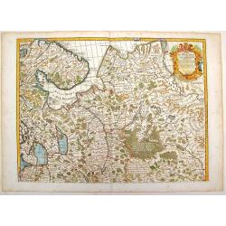
Golfo di Finlandia colle Provincie della Finlandia russa, Carelia, Ingria, Estonia, Nylandia.
Detailed map of the Gulf of Finland, with St. Petersburg in the east. With Helsinki, Tallinn and Haapsalu in Estonia.
Date: Venice, 1780
Selling price: ????
Please login to see price!
Sold in 2014
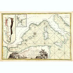
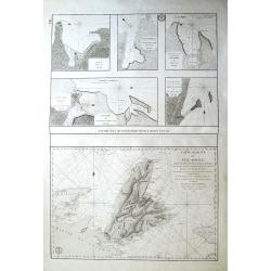
.Carte reduite de la partie occidentale de la mer Mediterranée.
Scarce chart of the Mediterranean published by André Basset. With insets of "Detroit de Gibraltar." and "Plan de Gibraltar". According to the title &...
Date: Paris, 1780
Selling price: ????
Please login to see price!
Sold in 2016
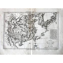
Empire de la Chine, Rme. de Coree, ad Isles Du Japon.
Very attractive map of China that includes 11 different scales.
Date: Paris, c. 1780
Selling price: ????
Please login to see price!
Sold in 2018
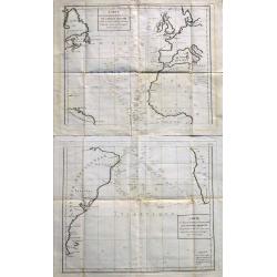
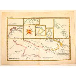
Carte Des Declinaisons Et Inclinaisons De L'Aiguille Aimantee Tables 1 and 2.
An important, very large chart of the Atlantic Ocean on two sheets, which can be joined, showing magnetic inclination and declination. Probably compiled from La Perouse's...
Date: Paris, ca 1780
Selling price: ????
Please login to see price!
Sold in 2023
Plans particuliers dependans de l'Île Royale & Carte réduite de l'Île Royale...
Seven rare sea-charts on one large sheet. With the large and detailed chart of Île Royale and Île Saint-Jean (now known as Cape Breton Island and Prince Edward Island) ...
Date: Paris, 1780
Selling price: ????
Please login to see price!
Sold in 2015
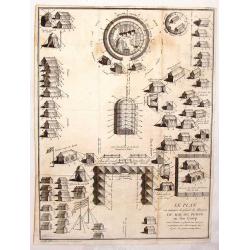
Le Plan ou Maniere de Placer la Maison du Roi de Perse en Son Camp.
Interesting military print from "Illustrations de Lettres édifiantes et curieuses" by J.G. Merigot. Engraved by Nicolas Ransonnette in 1780.
Date: Paris, 1780
Selling price: ????
Please login to see price!
Sold in 2016

Nouvelle Mappe Monde dediee au progres de nos connoissances.
A handsome and well-engraved world map constructed with the prime meridian through Paris. The hemispheres are rotated through 45 degrees. This is an unusual projection fo...
Date: Venice, 1780
Selling price: ????
Please login to see price!
Sold in 2018
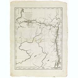
(Map showing the Albany-Oswego waterway)
Rare map of Upstate New York, showing the Albany-Oswego waterway. With Lake Oneida in the upper left part, showing towns as Sparte and Heurville, with land particions. &q...
Date: Paris, ca. 1780
Selling price: ????
Please login to see price!
Sold in 2015
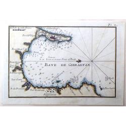
Baye de Gibraltar.
Fine miniature map featuring the Bay of Gibraltar. Hand colored copperplate by Joseph Roux in about 1780. Note that North is to the left.
Date: Paris, 1780
Selling price: ????
Please login to see price!
Sold in 2015
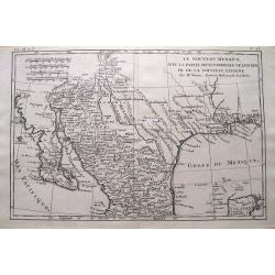
Le Nouveau Mexique, Avec La Partie Septentrionale De L'Ancien, ou De La Nouvelle Espagne.
Highly detailed map of the Southwest USA, from Baja California to West Florida, including parts of Mexico and a tip of Yucatan. With very interesting features: In Texas,...
Date: Paris, 1780
Selling price: ????
Please login to see price!
Sold in 2015
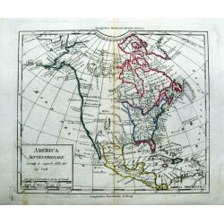
America Settentrionale Secondo le scoperte fatte dal Cap. Cook.
Uncommon italian map of North America. Outlining the United States east of the Mississippi river. With a large New Mexico, Maha Nation, and extensive blank areas in the N...
Date: ca. 1780
Selling price: ????
Please login to see price!
Sold in 2015
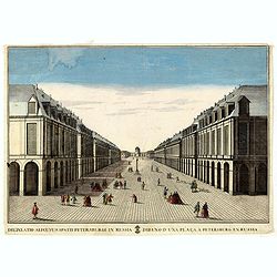
Delineatio Alicuyus Spatii Petersburgi in Russia. / Dibuxo d'una plaça a Petersburg en Russia.
Print of a street in Petersburg in Russia.By Giuseppe Remondini (1745-1811) was a well-known Italian publisher of optical prints. In the eighteenth and nineteenth centuri...
Date: Augsburg, 1780
Selling price: ????
Please login to see price!
Sold in 2016
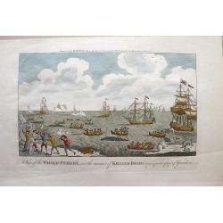
A View of the Whale-Fishery, and the manner of Killing-Bears near and on the Coast of Greenland.
Nicely rendered copperplate engraving showing several ships and about a dozen longboats with men harpooning whales. Icebergs float in the sea. On the shore, a small group...
Date: London, 1780
Selling price: ????
Please login to see price!
Sold in 2015
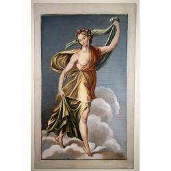
Female Classical Figure in yellow dress.
Copper engraving on laid paper. overall size 36 x 22,5 cm. Very beautifully hand colored print of a classical figure.
Date: Italian (?), ca. 1720-1780
Selling price: ????
Please login to see price!
Sold in 2015

Female Classical Figure with red Shawl.
Copper engraving on laid paper. overall size 36 x 22,5 cm. Very beautifully hand colored print of a classical figure.
Date: Italian (?), 1720-1780
Selling price: ????
Please login to see price!
Sold in 2015

Prospectus partis interioris Templi Carthusiae Papiensis in Italy / Vue perspective du dedans de L'eglise des Chartreux de Pavie en Italie.
So called optical print by the famous Italian publishing firm Remondini.Giuseppe Antonio Remondini (1634 -1711), around 1660, founded a printing office where he developed...
Date: Bassano del Grappa, 1780
Selling price: ????
Please login to see price!
Sold in 2015
![[Marco square in Venice.]](/uploads/cache/36224-250x250.jpg)
[Marco square in Venice.]
So called optical print by the famous Italian publishing firm Remondini.Giuseppe Antonio Remondini (1634 -1711), around 1660, founded a printing office where he developed...
Date: Bassano del Grappa, 1780
Selling price: ????
Please login to see price!
Sold in 2015
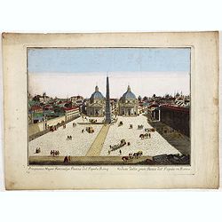
Prospectus Magni Fori, vulgo Piazza del Popolo, Rome. Veduta della gran Piazza del Popolo, in Roma. N 4.
View of Rome with the Piazza del Popolo. So called optical print by the famous Italian publishing firm Remondini.Giuseppe Antonio Remondini (1634 -1711), around 1660, fou...
Date: Bassano del Grappa, 1780
Selling price: ????
Please login to see price!
Sold in 2015
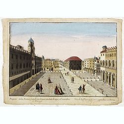
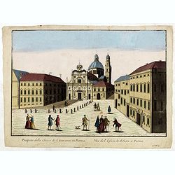
Prospetto della Piazza grande con li suoi condotti di aque, ed' imondizie in Parma.
View of Giuseppe Garibaldi square in Parma, with captions in Italian and French below image, without address. “Ll. No. 1” in lower right bottom. So called optical pri...
Date: Bassano del Grappa, 1780
Selling price: ????
Please login to see price!
Sold in 2015
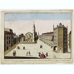
Prospetto della Chiesa Cattedrale con sua piazza con l'antica Capella in Parma.
View of Piazza Duomo con il Battistero in Parma, with captions in Italian and French below image, without address. “Ll. No. 2” in lower right bottom. So called optica...
Date: Bassano del Grappa, 1780
Selling price: ????
Please login to see price!
Sold in 2015
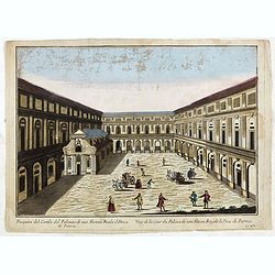
Prospetto del Cortile del Palazzo di sua Altezza Reale il Duca di Parma.
View of the Palace of the Duc of Parma, with captions in Italian and French below image, without address. “Ll. No. 3” in lower right bottom. So called optical print b...
Date: Bassano del Grappa, 1780
Selling price: ????
Please login to see price!
Sold in 2015
Prospetto della Chiesa di S. Gioavanni in Parma.
View of the S. Giovanni Church in Parma, with captions in Italian and French below image, without address. “Ll. No. 4” in lower right bottom. So called optical print ...
Date: Bassano del Grappa, 1780
Selling price: ????
Please login to see price!
Sold in 2015
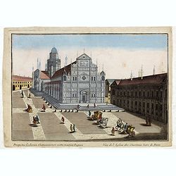
Prospectus Ecclesiae chartusianorum extra moenia Papiae. Vue de l'eglise des Chartreux hors de Pavie.
View of the Pavia Cathedral, with captions in Italian and French below image. So called optical print by the famous Italian publishing firm Remondini.Giuseppe Antonio Rem...
Date: Bassano del Grappa, 1780
Selling price: ????
Please login to see price!
Sold in 2015
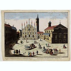
Prospectus Ecclesiae Carmelitarum, et SS Trinitatis Papiae. Vue des Eglise des Carmes, et de la Trinité Pavie
View of the Church Of Santa Maria Del Carmine in Pavia, with captions in Italian and French below image. "Z N° 1." in lower left corner.So called optical print...
Date: Bassano del Grappa, 1780
Selling price: ????
Please login to see price!
Sold in 2015
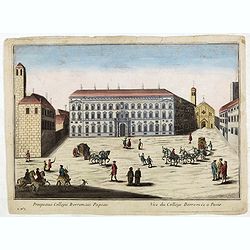
Prospectus Collegii Borromaei Papaiae. Vue du Collége Borromée a Pavie.
View of the Collegio Borromeo in Pavia, with captions in Italian and French below image. "Z N° 2." in lower left corner.So called optical print by the famous I...
Date: Bassano del Grappa, 1780
Selling price: ????
Please login to see price!
Sold in 2015

