Browse Listings
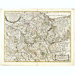
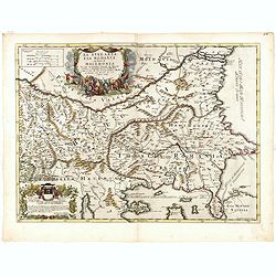
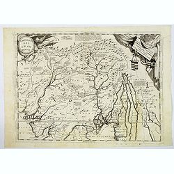
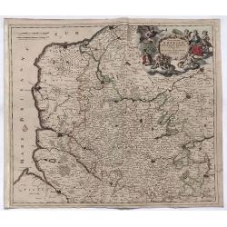
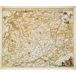
Marchesato, Et Elettorato di Brandeburg. . .
Rossi's map of Northern Germany, based upon Sanson's map, but with revised Italian nomenclature. The engraver was Francesco Donia Messis.Issued in a second edition of Il ...
Date: Rome, 1688
Selling price: ????
Please login to see price!
Sold in 2015
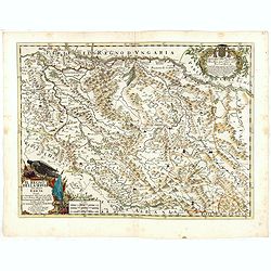
![[Two sheet map] L'Ungaria nuovamente descritta, et accresciuta di varie noti . . .](/uploads/cache/36396-250x250.jpg)
[Two sheet map] L'Ungaria nuovamente descritta, et accresciuta di varie noti . . .
Rossi's two sheet map of Hungary, based upon Sanson's map, but with revised Italian nomenclature. The engraver was Vinc. Mariotte.Issued in second edition of Il Mercurio ...
Date: Rome, 1688
Selling price: ????
Please login to see price!
Sold in 2015
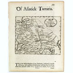
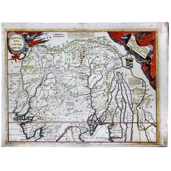
A New Description of Tartarie.
A pleasing small map of Tartary (northeastern Russia and China) showing mountains, Caspian Sea, Lakes and rivers, and The Great Wall of China, towns and cities.This lovel...
Date: London, c 1688
Selling price: ????
Please login to see price!
Sold in 2017
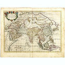
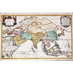
L'Asia Nuovamente corretta et accresciuta, secondo le relationi piu moderne da Guglielmo Sansone . . . 1677
Giacomo Rossi's fine late 17th century map of the Asian continent. Nice detail of the Philippines, China and Arabia. The area north of Japan called Yuppi and attached to ...
Date: Rome, 1677-1688
Selling price: ????
Please login to see price!
Sold in 2017
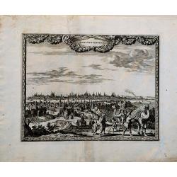
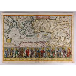
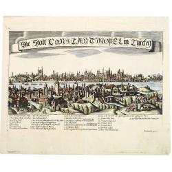
Constantinopel
This very rare bird's-eye view shows Istanbul across the Bosphorus. It is beautifully engraved with many details and scenes of every-day life, including merchants with ca...
Date: Amsterdam, ca. 1688
Selling price: ????
Please login to see price!
Sold in 2018
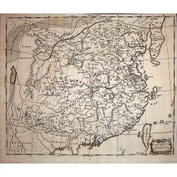
Imperium Sinarum.
Extremely rare map of China from Das mächtige Kayser-Reich Sina by Johann Christoph Wagner and published by Jakob Koppmayer. The book is a "rambling compilation&quo...
Date: Augsburg, 1688
Selling price: ????
Please login to see price!
Sold in 2017
![[Title page] Atlas minor sive geographica compendiosa..](/uploads/cache/39733-250x250.jpg)
[Title page] Atlas minor sive geographica compendiosa..
Title page of the Atlas minor of Visscher. De Wit's atlas was first issued in the 1670's with 17 maps, and throughout the 1680's the atlas was expanded as new maps were p...
Date: Amsterdam, 1688
Selling price: ????
Please login to see price!
Sold in 2020
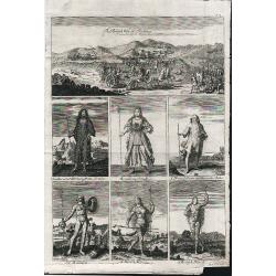
The British Way of Fighting.
A late 17th century engraving by the Flemish engraver Michael Vandergucht. Seven scenes, The British Way of Fighting, An Ancient Britain, Boadicea, A Druid, A Britain, A ...
Date: London, 1688
Selling price: ????
Please login to see price!
Sold in 2018
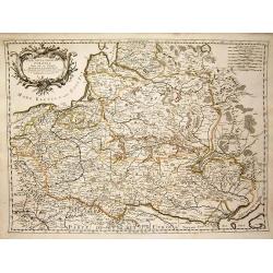
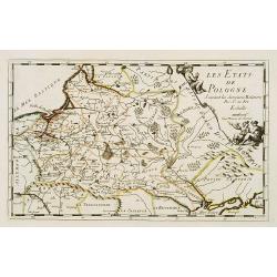
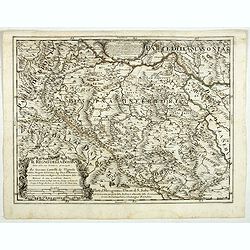
Stati Della Corona di Polonia.
Title: 'Stati Della Corona di Polonia', from the La Guida Del Mercurio Geografico per Tutte Le Parti Del Mondo. Map title inside cartouche of crossed weapons and a crown ...
Date: Rome, 1683-1688
Selling price: ????
Please login to see price!
Sold in 2019
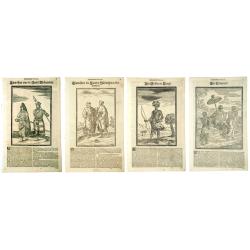
AUSLANDISCHEN NATIONEN. Von Happel THESAURUS EXOTIROCUM (Congo, Numidien, Madagascar)
Five woodcuts taken from 'Thesaurus Exoticorum'.
Date: Hamburg, 1688
Selling price: ????
Please login to see price!
Sold in 2020
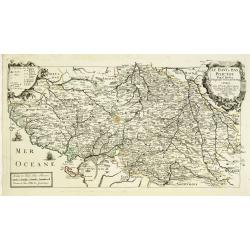
Le Haut et Bas Poictou. . .
Uncommon centered map of French province Poitou with fine title cartouche upper right.More about [+]
Date: Paris, 1689
Selling price: ????
Please login to see price!
Sold in 2012
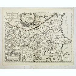
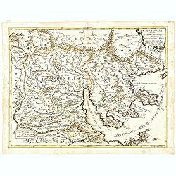
La Bulgaria ela Romania con Parte di Marcedonia. . .
Scarce map of the region along Danube River and to the south. Extends to include part of the Sea of Azov and the northern extreme of the Aegean Sea. Elaborate military-th...
Date: Rome, 1689
Selling price: ????
Please login to see price!
Sold in 2012
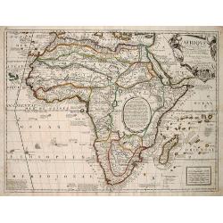
AFRIQVE | selon les Relations les plus Nouvelles | Dressée et Dediée | Par le P. Coronelli Cosmographe de la Sere- | nissime Republique de VENISE . | A Monseigneur le Duc de BRISS
This is an important transitional map of Africa. This map is not regularly found in atlases, but is usually found as a separate map. This map almost completely omits th...
Date: Paris, 1689
Selling price: ????
Please login to see price!
Sold in 2012
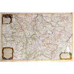
Il Ducato Dibar - Il Ducato Lorena.
A truly remarkable, large map with three decorative cartouches. It features a high degree of detail of the Duchies of Bar and Lorena in France.Giacomo Cantelli da Vignola...
Date: Rome, 1689
Selling price: ????
Please login to see price!
Sold in 2013
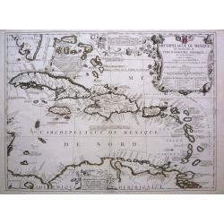
Archipelague du Mexique ou Sont les Isles de Cuba, Espagnole, Jamaique, etc avec les Isles Lucayes, et les Isles Caribes. . .
A superb decorative map of the West Indies originally done by Coronelli, later improved and revised by Tillemon for Nolin.The map provides alternate spellings of many Car...
Date: Paris, 1689
Selling price: ????
Please login to see price!
Sold in 2017
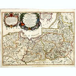
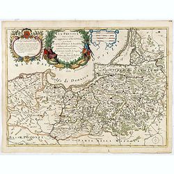
La Prussia Divisa in Reale Che Appartiene al Ré Di Polonia et in Ducale Che Spetta all'Elettore Di Brandeburgo. Da Giacomo Cantelli Da ...
In upper left hand corner a large title cartouche with dedication to Cardinal Denhoff. The map is dated 1689.The cartographer was Giacomo Cantelli (1643-1695) who was act...
Date: Rome, 1689
Selling price: ????
Please login to see price!
Sold in 2014
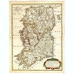
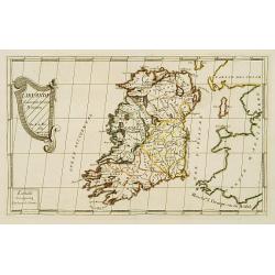
L\'Irlanda o uero Hibernia...
Giacomo Rossi's fine late 17th century map of Ireland. Issued in Il Mercurio geografico In lower right a tittle cartouche.The cartographer was Giacomo Cantelli da Vignola...
Date: Rome, 1689
Selling price: ????
Please login to see price!
Sold in 2015
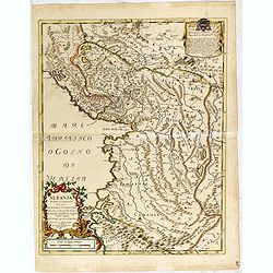
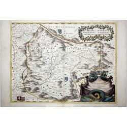
Albania propria ouero superiore...
Scarce Vignola's map of Albania, with decorative cartouches for the title (bottom left) and dedication (top right). The well educated humanist Giacomo Cantelli da Vignola...
Date: Rome, 1689
Selling price: ????
Please login to see price!
Sold in 2015
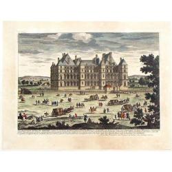
Le Chateau Royal de Madrid.
Highly detailed, hand-colored copper engraving of the royal palace in Spain. By the Perelle family of France. From "Vues de France" published in 1689.
Date: Paris, 1689
Selling price: ????
Please login to see price!
Sold in 2017
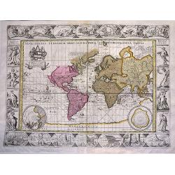
Nova Totius Terrarum Orbis Geographica ac Hydrographica Tabula.
An extremely decorative world map. It appeared in the famous 'English Atlas' by Moses Pitt and Steven Swart and is based on an earlier engraved world map by Pieter van de...
Date: Oxford, 1689
Selling price: ????
Please login to see price!
Sold in 2019
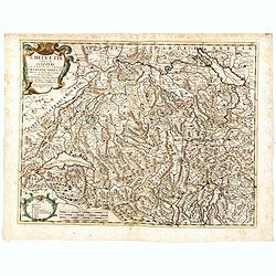
L'Helvetia . . .
A uncommon late 17th century map of part of Switzerland, including the Savoie region of France, based on the reports of Giacomo Cantelli da Vignola and published in Rome ...
Date: Rome, ca. 1689
Selling price: ????
Please login to see price!
Sold in 2015
La Prussia Divisa in Reale Che Appartiene al Ré Di Polonia et in Ducale Che Spetta all'Elettore Di Brandeburgo. Da Giacomo Cantelli Da ...
In upper left hand corner a large title cartouche with dedication to Cardinal Denhoff. The map is dated 1689.The cartographer was Giacomo Cantelli (1643-1695) who was act...
Date: Rome, 1689
Selling price: ????
Please login to see price!
Sold in 2016
La Bulgaria ela Romania con Parte di Marcedonia. . .
Scarce map of the region along Danube River and to the south. Extends to include part of the Sea of Azov and the northern extreme of the Aegean Sea. Elaborate military-th...
Date: Rome, 1689
Selling price: ????
Please login to see price!
Sold in 2018
Il Regno Della Servia..
Rossi's map of the kingdom of Serbia, bordered by Hungary to the north, Albania and Macedonia to the south, and Wallachia (present-day Romania) to the northeast. Borders,...
Date: Rome, 1689
Selling price: ????
Please login to see price!
Sold in 2016
Il regno della Bossima diviso nelle ...
Rossi's map of Bosnia, based upon Sanson's map.
Date: Rome, 1689
Selling price: ????
Please login to see price!
Sold in 2016
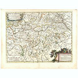
Paese d'Eiffel nel quale sono parte del ducato di Iuliers, il principato d'Arenberg, li stati di conti di Manderscheit. . .
Rossi's map of Eiffel region in Germany, based upon Sanson's map, but with revised Italian nomenclature. From his 'Mercurio Geografico...'. The engraver was Pietra Santa....
Date: Rome, 1689
Selling price: ????
Please login to see price!
Sold in 2015
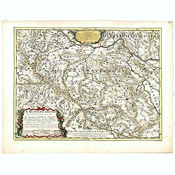
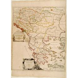
La Macedonia. . . (Northern Greece)
Rossi's map of Northern Greece with Thessaloniki, based upon Sanson's map, but with revised Italian nomenclature. The engraver was Francesco Donia Messis.Issued in a seco...
Date: Rome, 1689
Selling price: ????
Please login to see price!
Sold in 2016
![[4 sheet map] Le Diecisette Provincie de Paesi Bassi. . .](/uploads/cache/36418-250x250.jpg)
[4 sheet map] Le Diecisette Provincie de Paesi Bassi. . .
Scarce map of the Low Countries. Elaborate heraldic title cartouche. The engraver was A Barbey.
Date: Rome, 1689
Selling price: ????
Please login to see price!
Sold in 2016
![[Antique large map of Asia] L'Asie, Distinguée en ses Principales Parties.1687](/uploads/cache/97966-250x250.jpg)
[Antique large map of Asia] L'Asie, Distinguée en ses Principales Parties.1687
Alexis-Hubert Jaillot (1632-1712), French cartographer. he joined the Sanson heirs. He redrew Nicolas Sanson's maps on a larger scale. 'Atlas Nouveau' (1674), sea-atlas '...
Date: Paris, 1689
Selling price: ????
Please login to see price!
Sold in 2017
![[Antique large map of Asia] L'Asie, Distinguée en ses Principales Parties 1687.](/uploads/cache/98169-250x250.jpg)
[Antique large map of Asia] L'Asie, Distinguée en ses Principales Parties 1687.
Alexis-Hubert Jaillot (1632-1712), was a French cartographer. he joined the firm Sanson heirs. He redrew Nicolas Sanson's maps on a larger scale. 'Atlas Nouveau' (1674), ...
Date: Paris, 1689
Selling price: ????
Please login to see price!
Sold in 2018
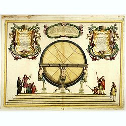
Illustrissimo, et Eccellentissimo.. Gran Globi ..
Celestial globe of the remarkable Vincenzo Coronelli (1650-1718), encyclopaedist, geographer, inventor and Doctor of Theology, was citizen of the Republic of Venice. He w...
Date: Venice, 1689
Selling price: ????
Please login to see price!
Sold in 2020
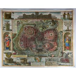
Jerusalem.
A SPLENDID Holy Land figural city plan of Jerusalem by Richard Blome and engraved by Jan Kip. A series of twelve border vignettes featuring biblical tombs and statues (K...
Date: London, 1689
Selling price: ????
Please login to see price!
Sold in 2017
A Mapp of the Travels and Voyages of the Apostales in Their Mission and in Particular of Saint Paul.
Beautiful Holy Land figural map of the travels of St. Paul and the Apostles by Richard Blome and engraved by Jan Kip. A series of thirteen border vignettes featuring the ...
Date: London, 1689
Selling price: ????
Please login to see price!
Sold in 2017
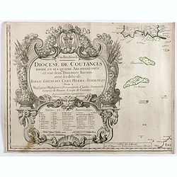
Diocese de Coutances, divisé en ses quatre archidiaconés . . .
Lower left sheet of this rare 4-sheet wall map, showing mainly a title cartouche with the islands of Minquiers and Banes Grélets to the right. In top right tip of Britan...
Date: Paris, ca. 1689
Selling price: ????
Please login to see price!
Sold in 2017
Paese d'Eiffel.
A map of Germany by Rossi in Rome in 1689. From the Atlas La Guida Del Mercurio. Featuring a floral title cartouche and a second cartouche with three putti and a family ...
Date: Rome, 1689
Selling price: ????
Please login to see price!
Sold in 2018
Etats de l'Eglise qui sont le Ferrarois, le Bolognois..
A RARE and attractive map of central part of Italy centered on Siena, Florence, Lucca, etc. A visually stunning map with a large title cartouche. Includes an inset map of...
Date: Paris 1689
Selling price: ????
Please login to see price!
Sold
L'Irlande suiant les dernieres relations..
Rare miniature map of Ireland by N. de Fer, dated 1689.
Date: Paris 1689
Selling price: ????
Please login to see price!
Sold
L'Angleterre et L'Ecosse suivant des dernieres relations..
Rare miniature map of England and Scotland by N. de Fer.
Date: Paris 1689
Selling price: ????
Please login to see price!
Sold
Les Etats de Pologne. Suivant des dernieres relations..
Rare miniature map of Poland by N. de Fer.
Date: Paris 1689
Selling price: ????
Please login to see price!
Sold
L'Irlande suiant les dernieres relations..
Rare miniature map of Europe by N. de Fer, dated 1689.
Date: Paris 1689
Selling price: ????
Please login to see price!
Sold
Le Royaume de Hongrie.. Turquie en Europe.. /.. Partie Meridionale de la Turquie en Europe..
Fine map of Hungary and the European part of Turkey.To the lower left a piece of paper is pasted in and the latitudes and longitudes scales are added in print. With the a...
Date: Paris 1689
Selling price: ????
Please login to see price!
Sold
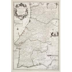
Le Portugal dedié au Roy.
From his first edition of his only folio atlas, the map is relied upon the map of his uncle, Nicolas Sanson. Engraved by Inselin.Nice map of Portugal with a very decorati...
Date: Paris 1689
Selling price: ????
Please login to see price!
Sold in 2008
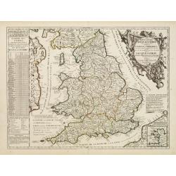
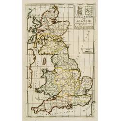
Le Royaume d'Angleterre Divise en plusieurs Parties..
Uncommon map of England. This large one-sheet map of England and Wales was produced by the Venetian cosmographer Vincenzo Coronelli when he was working in Paris in the 16...
Date: Paris, 1689
Selling price: ????
Please login to see price!
Sold in 2016
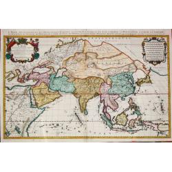
L\'Asie, Distinguée en ses Principales Parties.1687
Alexis-Hubert Jaillot (1632-1712), French cartographer. he joined the Sanson heirs. He redrew Nicolas Sanson's maps on a larger scale. 'Atlas Nouveau' (1674), sea-atlas '...
Date: Paris, 1689
Selling price: ????
Please login to see price!
Sold in 2015
Le Royaume d'Angleterre.
An attractive map centered on England, Wales and southern part of Scotland.
Date: Paris, 1689
Selling price: ????
Please login to see price!
Sold in 2008
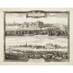
Sacrae Regiae Maj: Caroli Gustavi ..
Decorative panoramic views of Malmo and Landskrona in Sweden. Prepared by Count Erik Jönsson Dahlberg[h] (1625-1703). Military engineer and cartographer of Stockholm. He...
Date: Stockholm, 1689
Selling price: ????
Please login to see price!
Sold in 2011
L'Asie, Distinguée en ses Principales Parties.1687
Alexis-Hubert Jaillot (1632-1712), French cartographer. he joined the Sanson heirs. He redrew Nicolas Sanson's maps on a larger scale. 'Atlas Nouveau' (1674), sea-atlas '...
Date: Paris, 1689
Selling price: ????
Please login to see price!
Sold
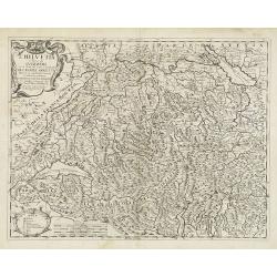
L'Helvetia . . .
A uncommon late 17th century map of part of Switzerland, including the Savoie region of France, based on the reports of Giacomo Cantelli da Vignola and published in Roma ...
Date: Rome, ca. 1689
Selling price: ????
Please login to see price!
Sold in 2009
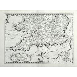
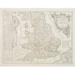
Parte Meridionale del Regno D'Inghilterra, Descritto, e Dedicato Dal P. Cosmografo Coronelli, All Illstrissimo, et Eccellentissimo Signor Caualiere Angelo Morosini, Procuratore de S. Marco, etc.
Attractive map of the Southern portion of England, extending North To 53 degrees. Shows counties, towns, roads, rivers and Islands, etc. Accompanying Italian text on vers...
Date: Venice, 1689
Selling price: ????
Please login to see price!
Sold in 2010
Constantinopolitanae urbis effigies ad vivum expressa.
Extremely rare panoramic view of Istanbul published by Jacob Koppmayr. With a numbered key (1-29) to principal places in town. Jacob Koppmayr was a printer and publisher ...
Date: Augsburg, 1689
Selling price: ????
Please login to see price!
Sold in 2011
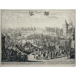
Het lande van syn Hoogh in Engelant.
William of Orange landing at Torbay; letters A-P within composition indicating different scenes. 1689. Lettered in Dutch in banderol in top center: "Het lande van sy...
Date: Amsterdam, 1689
Selling price: ????
Please login to see price!
Sold in 2011
Il regno della Bossima diviso nelle sue provincie principali. . .
Rossi's map of Bosnia, based upon Sanson's map, but with revised Italian nomenclature. From a second edition of his 'Mercurio Geografico...'. The engraver was Cl. Botzot....
Date: Rome, 1689
Selling price: ????
Please login to see price!
Sold in 2019
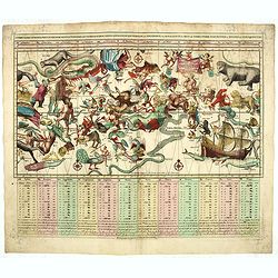
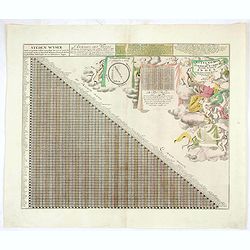
Sterre Kaert of Hemels Pleyn . . .
Early imprint, usually offered with the imprint of Elwe. A most attractive rectangular projection of the Heavens showing all the heavenly bodies and with panels of astrol...
Date: Amsterdam, 1690
Selling price: ????
Please login to see price!
Sold in 2022
Impero del Gran Mogol.
Northern India, with Pakistan, Bangladesh and the western part of Burma. Including Cabulistan, Kandauna, Harduari, Binsola, Burchar, Kachemire, Iamba, Ragepor and others....
Date: Venice, 1690
Selling price: ????
Please login to see price!
Sold in 2019
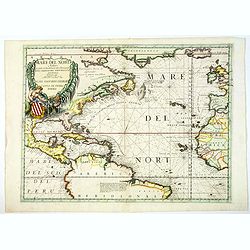
Mare del Nord.
This splendid maritime map shows the Atlantic Ocean between Iceland, Europe, West-Africa, northern Brazil and eastern Canada, including the Caribbean. Here Coronelli deli...
Date: Venice, 1690
Selling price: ????
Please login to see price!
Sold in 2020
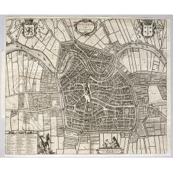
Harlemum, vulgo Haerlem, by Gregorio Leti, 1690.
A detailed and very decorative bird's-eye view of the Dutch city of Haarlem, with the city's and the province's coats of arms, together with two decorative cartouches at ...
Date: Amsterdam, 1690
Selling price: ????
Please login to see price!
Sold in 2020
IMPERO DEL GRAN MOGOL.
A fine ,very rarely contempory colored ! map.Coronelli's maps are rarely to be found in contempory color ! From an Italian oldcolored composite atlas , otherwise usually ...
Date: Venice, ca 1690
Selling price: ????
Please login to see price!
Sold in 2021
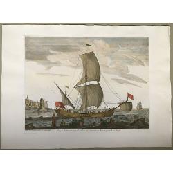
Saique bâtiment dont les Turcs se servent en tenant pour leur trafic.
A finely executed maritime engraving of a Turkish Saique (small sailing vessel) under full sail before a town. This was printed as part of a series of 17 folio copperplat...
Date: Marseille, ca. 1690
Selling price: ????
Please login to see price!
Sold in 2020
Candia.
A bird's eye view of the town of Heraklion, in Crete, engraved by Bouttats, G. Showing the siege of the Turks in 1667.
Date: Antwerp, ca. 1690
Selling price: ????
Please login to see price!
Sold in 2020
Novissima Artesiae Comitatus Tabula.
A fine original color example of Justus Danckerts map of Artois in France, published in Amsterdam in 1690. It features a decorative cartouche with eight putti.Justus Danc...
Date: Amsterdam, 1690
Selling price: ????
Please login to see price!
Sold in 2022
LA TRANSILVANIA. . .
A beautiful map of the Transilvanian regions in Romania, depicting several kingdom's crests around the map.
Date: Venetia, 1690
Selling price: ????
Please login to see price!
Sold in 2020
Ducatus Lutzenburgici Tabula Nuperrime in Lucem Edita per F. de Wit.
Frederick de Wit's handsome map of Luxembourg in fine original coloring. Frederik de Wit (1610-98), Amsterdam-based cartographer and publisher. 'Atlas minor', 1670,' Zee-...
Date: Amsterdam, ca 1690
Selling price: ????
Please login to see price!
Sold in 2020
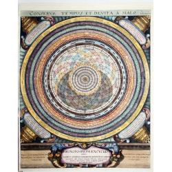
Conserva Tempus Et Devita a Malo.
Chart from from "Conserva Tempus et Devita a Malo," "Vol. 1, Page 280, Eccli. Cap. 4.V.23," by the seventeenth-century German author of Oculus Artific...
Date: Nutremberg, 1690
Selling price: ????
Please login to see price!
Sold in 2020
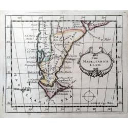
The Magellanick Land.
A rare miniature map of Patagonia from John Seller's 'A New Systeme of Geography'. With a compass and decorative title cartouche.
Date: London, 1690
Selling price: ????
Please login to see price!
Sold in 2020
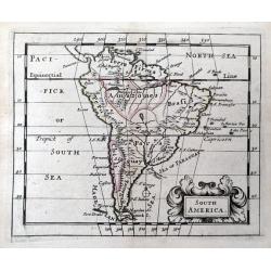
South America.
A rare miniature map of South America from John Seller's 'A New Systeme of Geography'. With a decorative title cartouche.
Date: London, 1690
Selling price: ????
Please login to see price!
Sold in 2020
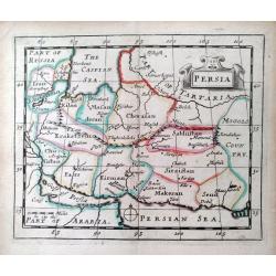
Persia.
A rare miniature map of Persia from John Seller's 'A New Systeme of Geography'.
Date: London, 1690
Selling price: ????
Please login to see price!
Sold in 2020
Astygnomon sive Europaearum urbium maxime insignium index. . . .
From "Atlas contractus sive mapparum geographicarum Sansoniarum auctarum et correctarum nova congeries". Showing tables with distances between European cities. ...
Date: Amsterdam, 1690
Selling price: ????
Please login to see price!
Sold in 2021
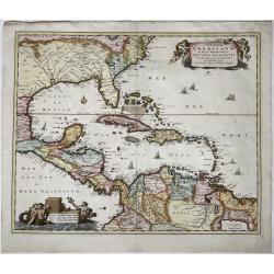
Insulae Americanae, in Oceano Septentrionali ac Regiones Adiacentes.
The full title and impressum in a cartouche held by putti top right: 'Insulae Americanae, in Oceano Septentrionali ac Regiones Adiacentes, a C. de May ad Lineam Aequinoct...
Date: Amsterdam, 1690
Selling price: ????
Please login to see price!
Sold in 2021
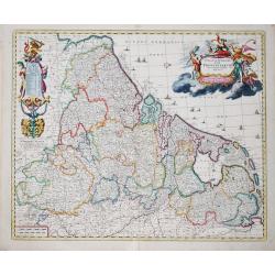
Germaniae Inferioris XVII PROVINCIARUM Accuratissima Tabula.
The third state of Nicolaas Visscher I's attractive map of the XVII Provinces of the Netherlands, published by his son Nicolaas II. Embellished with a large and decorativ...
Date: Amsterdam, ca 1690
Selling price: ????
Please login to see price!
Sold in 2023
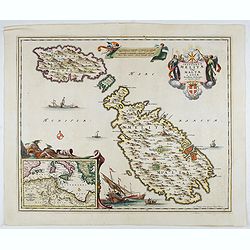
Insularum Melitae vulgo Maltae et Gozae. . .
A very attractive example of this detailed map of Malta and Gozo with inset map of the Western Mediterranean. Sailing ships and a large title cartouche with the Coat of A...
Date: Amsterdam, 1690
Selling price: ????
Please login to see price!
Sold in 2022

Teatro Belgico di Gregorio Leti Par. 1
Title page of Part 1 of Teatro Belgico by Gregorio Leti. With seven coats of arms of the provinces: Overijssel, Utrecht, Holland, Gelderland, Friesland, en Groningen. Mak...
Date: Amsterdam, 1690
Selling price: ????
Please login to see price!
Sold in 2022
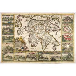
Peloponnesus Hodie Moreae Regnum Distincte Divisum in Omnes suas Provincias . . . Insulae Cefalonia, Zante, Cerigo et St. Maura Acore F. De Wit.
A rare, spectacular map in fine period color of the Peloponnese surrounded by 14 large city, port and fortress views and plans of important Greek cities including Athens,...
Date: Amsterdam, 1690
Selling price: ????
Please login to see price!
Sold in 2022
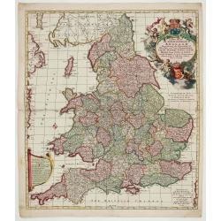
A New Mapp of the Kingdome of England.
Very decorative map of England and Wales by Nicolaes Visscher II, comes from the atlas “Atlas Minor, sive geographia compendiosa qua orbis terrarum. . . ”.
Date: Amsterdam, c. 1690
Selling price: ????
Please login to see price!
Sold in 2022
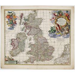
Magnae Britanniae Tabula; Comprehendens Angliae, Scotiae ac Hiberniae Regna
Very decorative map of Great Britain by Nicolaes Visscher II, dedicated to William III, King of England, Scotland and Ireland.Map comes from the atlas “Atlas Minor, siv...
Date: Amsterdam, c. 1690
Selling price: ????
Please login to see price!
Sold in 2023
![[ Lot of 9 maps and plans] Novissima nec non Perfectissima Scandinaviae Tabula](/uploads/cache/18177-(3)-250x250.jpg)
[ Lot of 9 maps and plans] Novissima nec non Perfectissima Scandinaviae Tabula
Frederick de Wit's large and detailled map of Scandinavia. Embellished with a large, decorative title-cartouche.From Frederick de Wit's' Atlas Maior'. Frederik de Wit (16...
Date: Amsterdam, 1690
Selling price: ????
Please login to see price!
Sold in 2022
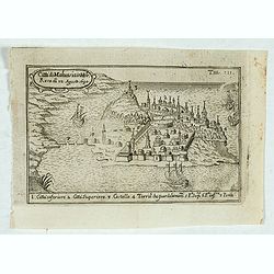
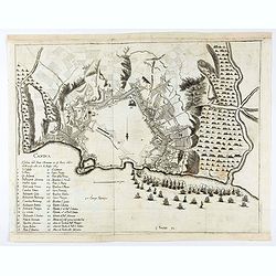
Citta di Malvasia in Mora Reas di 12 Agosto 1690.
Bird's-eye view of the island of Malvasia, nowadays called Monemvasia, with part of the eastern shore of the Peloponnese, showing the island fortress of Monemvasia in Gre...
Date: Italy, after 1690
Selling price: ????
Please login to see price!
Sold in 2023
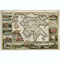
Peloponnesus Hodie Moreae regnum..
A rare, spectacular map of the Peloponnese surrounded by 14 large city, port and fortress views and plans of important Greek cities including Athens, Sparta, Lepanto, Mod...
Date: Amsterdam, 1690
Selling price: ????
Please login to see price!
Sold in 2023
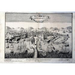
Coppenhague Ville Capitale du Royaume de Danemarck est située en Zeelande qui est une des Isles de la Mer BALTIQUE
Very rare, large decorative view of Copenhagen. The view shows an elaborate waterfront image, with wharves, windmills, shipbuilding, etc. 7 major sites are identified in ...
Date: Paris?, ca 1690
Selling price: ????
Please login to see price!
Sold in 2023
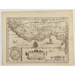
Guineae Nova Descriptio.
The map shows the West African coast from Senegal to Cape Lopez on the Gulf of Guinea just below the equator. The island of St. Thomae, which today forms a Portuguese pro...
Date: Amsterdam, W. de Jonge, 1690
Selling price: ????
Please login to see price!
Sold in 2023
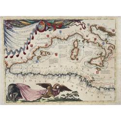
Ristretto del Mediterraneo...
Very large, extremely decorative map of the Western part of the Mediterranean Sea. It is embellished with coats of arms and decorative cartouches, Vincenzo Maria Coronell...
Date: Venice, 1690
Selling price: ????
Please login to see price!
Sold in 2023