Subscribe to be notified if similar examples become available.
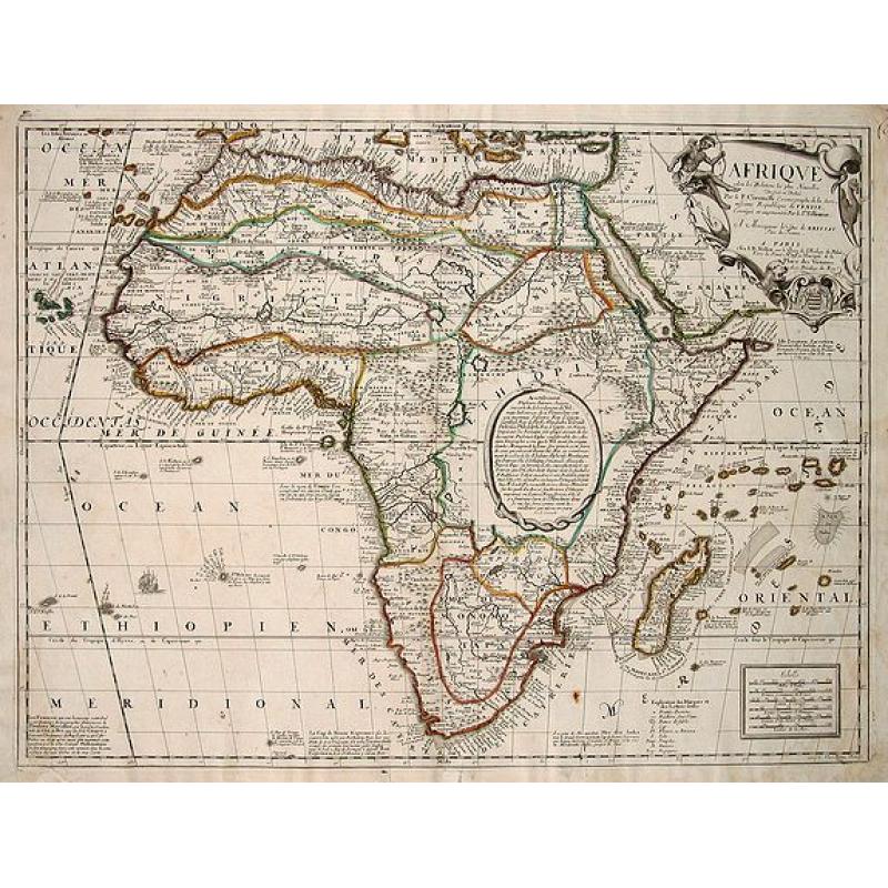
AFRIQVE | selon les Relations les plus Nouvelles | Dressée et Dediée | Par le P. Coronelli Cosmographe de la Sere- | nissime Republique de VENISE . | A Monseigneur le Duc de BRISS |
||||||||||||||||||||
|
||||||||||||||||||||
|
|
||||||||||||||||||||
|
Selling price: $ Please login to see price!
Sold in 2012 Missed this item! Add your name to our mailing list and be the first to get notified about our newly added listings. . |
My Collection +
Add this or any of your favorite items in one place. If you want to save the items permanently, you have to sign in or create an account first. |
|||||||||||||||||||
Description
This is an important transitional map of Africa. This map is not regularly found in atlases, but is usually found as a separate map.
This map almost completely omits the two Ptolemaic lakes in Central Africa, except for the lower portion of the western Lake Zaire. Within this central area of Africa, there is a large text oval describing the sources for the interior of Africa. This text was purposely placed here to demonstrate that the two lakes were likely based on tradition and not on fact. The text describes the Nile River as known to the ancients and mentions the Jesuit explorations in Abyssinia of Pedro Paez, Manuel de Almeida, and others. It culminates by describing Hiob Ludolf's Historia Aethiopia of 1681, with his important map of Abyssinia which helped to disprove Ptolemy's belief that the Nile begins in the Mountains of the Moon.
The text box is signed at the bottom with Coronelli's name (Le P[ère] Coronelli). The map does show the Abawi le Nil, Nilus fl. (Abay River or the Blue Nile) with its source in Tzana Lac (Lake Tana) in the Abyssinian highlands. It completely excludes the White Nile River with its true source further to the south in East Africa. Evidently, Coronelli believed that the Nile River had its primary source in the Abyssinian highlands as he labeled Tana as the source for the Nile on the map. In West Africa, the Niger River still retains its east-to-west orientation, arising in Lac Niger in Central Africa and emptying into the Atlantic Ocean.
This was a relatively consistent representation on maps since Leo Africanus' book, first published by Ramusio in 1550, described the Niger River. Above the Niger, the Nubia River continues its west-to-east flow into the Nile River by Egypt. Besides attempting to correct the river systems of Africa, this map represents a tremendous step forward in its use of additional placenames reflecting up-to-date knowledge of European explorations and permanent settlements. This can be seen along the African coasts, as well as in the interior in West Africa, in Abyssinia, up the Rio Zambeze (the Zambezi River showing the town of Tete), and along the South African coast with the addition of Bay Haut (Hout Bay), etc. Some of the older representation of the interior remains however, such as Castel Portugal in the interior of Southern Africa.
This map was elegantly engraved by Hendrik van Loon (Van Loon's name as the engraver, 'H. van Loon Sculp.', is at the bottom right of the map between the gridline and the neatline). Van Loon was employed by various publishers in late seventeenth century Paris, including Nolin and De Fer, to engrave a variety of maps. To the left of the scale bar there is a map key identifying various types of places on the map.
Jean Baptiste Nolin (1657-1708) was known as a Parisian engraver and publisher. Nolin is probably best known for publishing the maps and globes of the noted Venetian Vincenzo Coronelli. From 1681 to 1683, Coronelli had worked in Paris to produce an enormous pair of terrestrial and celestial globes for King Louis XIV. It is not clear if Nolin had established a relationship with Coronelli, who was only seven years his senior, during this time. In any event, he began to publish a series of separately-issued maps of various areas of the world including this map of Africa which used much of the geographic information provided by Coronelli's detailed globe gores.
It is possible that Nolin simply copied Coronelli's work without permission as he was later charged with copying the maps of Delisle in 1706 without permission. However, it appears that Nolin had Coronelli's approval to publish his maps including this one of Africa. Helen Wallis (Map Collector Magazine, 1982: 32-33) states that Coronelli had secured a 15-year privilege from King Louis XIV for the publication of his maps and had granted Nolin exclusive rights.
Reference: Betz, The Mapping of Africa: A Cartobibliography of Printed Maps of the African Continent to 1700, Map #146. Norwich, Map #85 (fourth state of the map).
FAQ - Guarantee - Shipping
Buying in the BuyNow Gallery
This item is available for immediate purchase when a "Add to Cart" or "Inquire Now" button is shown.
Items are sold in the EU margin scheme
Payments are accepted in Euros or US Dollars.
Authenticity Guarantee
 We provide professional descriptions, condition report (based on 45 years experience in the map business)
Paulus Swaen warrants the authenticity of our items and a certificate of authenticity is provided for each acquired lot.
Condition and Coloring
We indicate the condition of each item and use our unnique HiBCoR grading system in which four key items determine a map's value: Historical Importance, Beauty, Condition/Coloring and Rarity.
Color Key
We offer many maps in their original black and white condition. We do not systematically color-up maps to make them more sellable to the general public or buyer.
Copper engraved or wood block maps are always hand colored. Maps were initially colored for aesthetic reasons and to improve readability. Nowadays, it is becoming a challenge to find maps in their original colors and are therefor more valuable.
We use the following color keys in our catalog:
Original colors; mean that the colors have been applied around the time the map was issued.
Original o/l colors; means the map has only the borders colored at the time of publication.
Colored; If the colors are applied recently or at the end of the 20th century.
Read more about coloring of maps [+]
Shipping fee
A flat shipping fee of $ 30 is added to each shipment by DHL within Europe and North America. This covers : International Priority shipping, Packing and Insurance (up to the invoice amount).
Shipments to Asia are $ 40 and rest of the world $50
We charge only one shipping fee when you have been successful on multiple items or when you want to combine gallery and auction purchases.
Read more about invoicing and shipping
FAQ
Please have a look for more information about buying in the BuyNow gallery
Many answers are likely to find in the general help section.
My Collection+
![]()
With My Collection+ you can collect all your favorite items in one place. It is free, and anyone can create his or her virtual collection.
Unless you are logged in, the item is only saved for this session. You have to be registed and logged-in if you want to save this item permanently to My Collection+.
Read More[+]
Register here, it is free and you do not need a credit card.
Add this item to
My Collection+
or click the following link to see My Collection+.
| Digital Image Download | |
|
Paulus Swaen maintains an archive of most of our high-resolution rare maps, prints, posters and medieval manuscript scans. We make them freely available for download and study. Read more about free image download |
Click the image for a free small image download. |
In accordance with the EU Consumer Rights Directive and habitually reside in the European Union you have the right to cancel the contract for the purchase of a lot, without giving any reason.
The cancellation period will expire 14 calendar days from the day after the date on which you or a third party (other than the carrier and indicated by you) acquires, physical possession of the lot. To exercise the right to cancel you must inform Paulus Swaen Inc, of your decision to cancel this contract by a clear statement (e.g. a letter sent by post, or e-mail.
To meet the cancellation deadline, it is sufficient for you to send your communication concerning your exercise of the right to cancel before the cancellation period has expired.
