Browse Listings
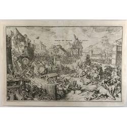
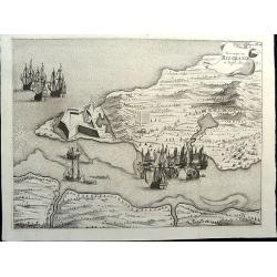
Siege et Prise d'Amida.
A striking R. de Hooghe 1690 copperplate print featuring the Siege of Amida, Mesopotamia. (modern-day Iraq). The plate features the city of Straasbourg and the Roman &am...
Date: Amsterdam, 1690
Selling price: ????
Please login to see price!
Sold in 2020
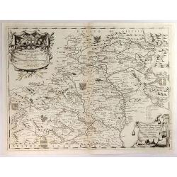
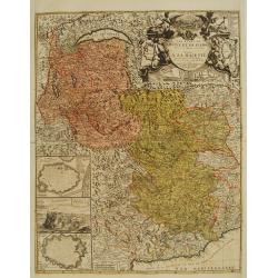
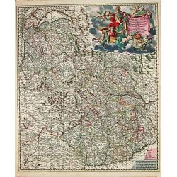
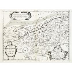
Marcomania Hoggidi Marchesato de Moravia Detto Volgarmente Marnhem. . .
A lovely map of Moravia centered on Brno and filled with well-engraved mountains, forests, coats of arms and cities. The map is dedicated to Andrea Bragadin within the el...
Date: VENICE, 1690
Selling price: ????
Please login to see price!
Sold in 2021
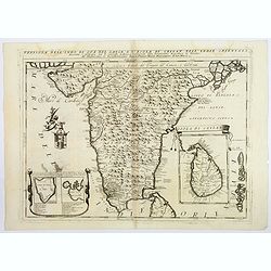
Penisola Dell' Indo di qua del Gange e L'Isola di Ceilan nell' Indie Orientale. . .
Coronelli's attractive double page copper engraved map of India below the Tropic of Cancer, with a pair of lovely insets of Trincomalee harbour and the island of Ceylon (...
Date: Venice 1690
Selling price: ????
Please login to see price!
Sold in 2018
![[Il mondo a pezzi - Europa].](/uploads/cache/42849-250x250.jpg)
[Il mondo a pezzi - Europa].
Satirical representation of the division of the world by the main European powers. At the center of the scene a globe on which is written "MONDO Maledeto Interesse ...
Date: Bologna, 1690
Selling price: ????
Please login to see price!
Sold in 2025
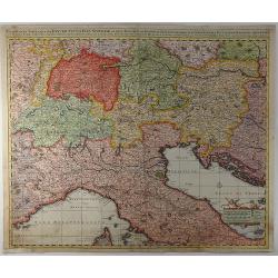
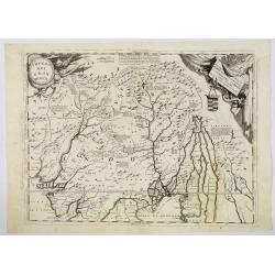
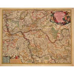
Exactissima Tabula Qua Tam Danubii Fluvii Pars Superior. . .
A highly detailed map of the Upper Danube and the Sea of Liguria (or Genoa), published by Nicolaus Visscher in 1690. The map extends from the headwaters of the Danube in ...
Date: Amsterdam, 1690
Selling price: ????
Please login to see price!
Sold in 2019
Impero del Gran Mogol.
Northern India, with Pakistan, Bangladesh and the western part of Burma. Including Cabulistan, Kandauna, Harduari, Binsola, Burchar, Kachemire, Iamba, Ragepor and others....
Date: Venice, 1690
Selling price: ????
Please login to see price!
Sold in 2019
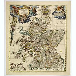
Exactissima regni Scotiae tabula. . .
A superb map of Scotland by Visscher, published in Amsterdam at the end of the seventeenth century. All the Scottish counties are colored in outline. There is a tremendou...
Date: Amsterdam, 1690
Selling price: ????
Please login to see price!
Sold in 2019
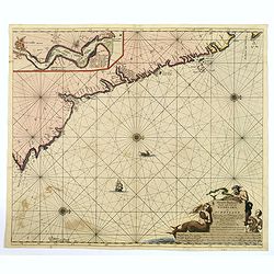
Nieuwe Pas-kaert vande Oost Kust van Engeland en Schotland. . .
A delightful Dutch maritime chart that includes the east coast of England, running from Berwick in Northumberland, southwards to Burlington in Yorkshire. A nice inset map...
Date: Amsterdam, 1690
Selling price: ????
Please login to see price!
Sold in 2019
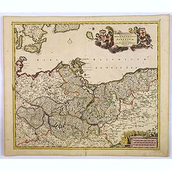
Marchionatus Brandenburgi et Ducatus Pomeraniae Tabula. . .
An attractive map of Brandenburg and Pommeren. Embellished with a title-cartouche with winged putti, fronds and a pair of coats-of-arms, plus a cartouche with three sets ...
Date: Amsterdam, 1690
Selling price: ????
Please login to see price!
Sold in 2019
![Cuba Insula [on sheet with] Hispaniola Insula [and] Ins. Iamaica [and] Ins. S. Ioannis [and] I.S. Margareta.](/uploads/cache/82456-250x250.jpg)
Cuba Insula [on sheet with] Hispaniola Insula [and] Ins. Iamaica [and] Ins. S. Ioannis [and] I.S. Margareta.
A fine map of the important islands in the West Indies. This Cloppenburgh map features the islands, wonderful cartouches, distance scales, and several sailing ships decor...
Date: Amsterdam, 1690
Selling price: ????
Please login to see price!
Sold in 2020
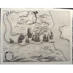
Veroveringe van Rio Grande in Brasil. Anno 1633 Northern Brazil.
A bird's-eye view of the fort (present-day Natal) at the mouth of the Rio Potengi showing the Dutch invasion and capture of the Portuguese fort in 1633. The harbor is fil...
Date: Amsterdam, 1690
Selling price: ????
Please login to see price!
Sold in 2021
T'Neemen van de Suyker Prysen inde Bay de Tode los Santos Anno 1627.
A nice copper engraving illustrating the Dutch fleet capturing the fort at the entrance to the Baia de Todos os Santos, in northeastern Brazil. The WIC fleet that capture...
Date: Amsterdam, 1690
Selling price: ????
Please login to see price!
Sold in 2021
![Povo [with] Villa d Olinda d Pernambuco.](/uploads/cache/82460-250x250.jpg)
Povo [with] Villa d Olinda d Pernambuco.
These splendid views encompass one of the earliest etchings of this region and its cities. Artistically engraved armies, fortresses, and ships. At top is a view of Pov...
Date: Amsterdam, 1690
Selling price: ????
Please login to see price!
Sold in 2021
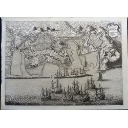
Afbeeldinge vande Cabo St. Augustin met Haer Forten.
This fine bird's-eye view portrays the Dutch fleet and the fortresses at Cabo Santo Agostinho. The strapwork title cartouche incorporates a numbered key identifying four ...
Date: Amsterdam, 1690
Selling price: ????
Please login to see price!
Sold in 2021
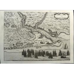
Afbeeldinghe van Pariba ende Forten.
This bird's-eye map shows the region of Paraiba and Portuguese fortifications at the mouth of the River Paraiba. A very early view of this region with highly detailed and...
Date: Amsterdam, 1690
Selling price: ????
Please login to see price!
Sold in 2021
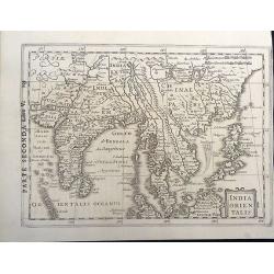
India Orientalis.
This is a very rare map and a reduced version of Jodocus Hondius' folio map of South East Asia. It covers the region from India through southern China and the Philippines...
Date: Amsterdam, 1690
Selling price: ????
Please login to see price!
Sold in 2020
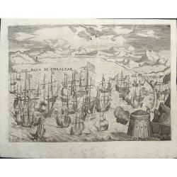
Sea battle in the Baya de Gibraltar.
Print of the sea battle in the Bay of Gibraltar. On the right the city, on the right in the foreground a fort. Shots are fired from this fort as well as from the ramparts...
Date: Amsterdam, 1690
Selling price: ????
Please login to see price!
Sold in 2021
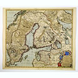
Regni Sueciae Tabula Generalis, divisia in Suediae, Gothiae. . .
An attractive and detailed map of Scandinavia, centered on Finland, including parts of Sweden, Norway and Russia. Nicely colored to accentuate the seas, mountains, lakes ...
Date: Amsterdam, 1690
Selling price: ????
Please login to see price!
Sold in 2019
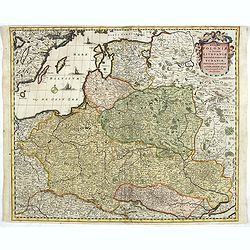
Regni Poloniae et Ducatus Lithuaniae Voliniae, Podoliae..
Standard map of Poland.
Date: Amsterdam, 1690
Selling price: ????
Please login to see price!
Sold in 2019
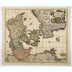
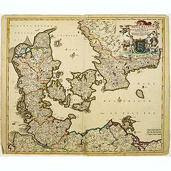
Dania Regnum In quo sunt Ducatus Holsatia et Slesvicum Iutia, et Insule, dictae Danicae. . .
An attractive map centered on Denmark and including southern tip of Sweden. Enhanced by a very ornamented title cartouche in the upper right-hand corner. colored mileage ...
Date: Amsterdam ca 1690
Selling price: ????
Please login to see price!
Sold in 2020
![ADEN.[Yemen]](/uploads/cache/82807-250x250.jpg)
ADEN.[Yemen]
A beautifully old colored view of Aden by Koppmayer, Augsburg.
Date: Augsburg, 1690
Selling price: ????
Please login to see price!
Sold in 2021
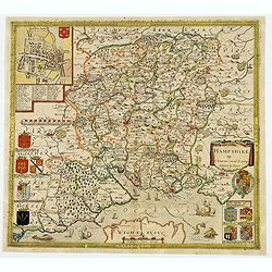
Hampshire.
Christopher Saxton’s sumptuous county map of Hampshire together with the northern part of the Isle of Wight, first issued in 1575, 'Corected & many Additions by P. ...
Date: London, ca 1690
Selling price: ????
Please login to see price!
Sold in 2021
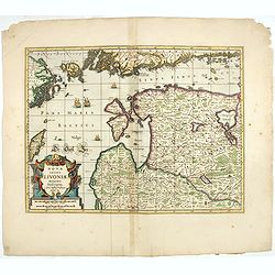
Nova Totius Livoniae accurata Descriptio.
The excellent, and decorative map of Livonia from the Moses Pitt "The English Atlas". Map extent is southern most tip of Sweden, part of the southern coast of F...
Date: Oxford, 1690
Selling price: ????
Please login to see price!
Sold in 2023

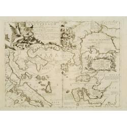
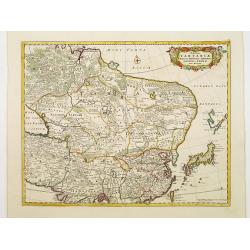
Iunan, Queichev, e Quangsi Provincie della Cina. . .
A beautiful map depicting the area of Beijing with decorative title cartouche and scale cartouche. Information about the area at the top of the map.The remarkable Vincenz...
Date: Venice, 1690
![De kust der Zuyd zee.. [4 maps]](/uploads/cache/15730-250x250.jpg)
De kust der Zuyd zee.. [4 maps]
Four sheets covering the coasts from Southern Mexico until Chilli. Each maps is clearly engraved and belongs to an text page as each map has a page reference.Rare.
Date: Amsterdam c.1690
Selling price: ????
Please login to see price!
Sold
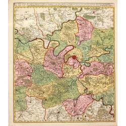
Archiepiscopatus et Electoratus Moguntini..
Centred on Frankfurt, Mainz and Heidelberg.
Date: Amsterdam, 1690
Selling price: ????
Please login to see price!
Sold in 2022
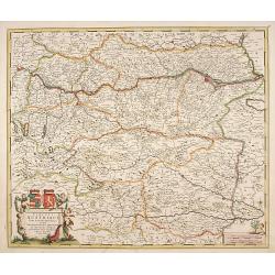
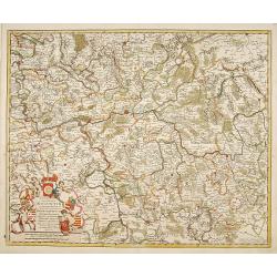
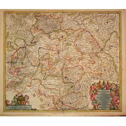
Circuli Austriaci pars Septentrionalis in qua Archiducatus.
Decorative and detailed map of Austria.
Date: Amsterdam, 1690
Selling price: ????
Please login to see price!
Sold in 2023
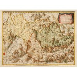
Partie Meridionale des Estats de Savoye..
"Map of Savoie. With original or early outline hand-color. Numerous place-names of counties, cities, towns, physical features. Prepared by N.Sanson.This edition carr...
Date: Paris 1690
Selling price: ????
Please login to see price!
Sold in 2009
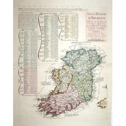
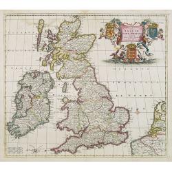
Isle et Royaume d'Irlande..
"Detailed map of Ireland, including also a list of all the counties and main towns and their location. With the address "" A Paris chez le Sr. N. De Fer, d...
Date: Paris 1690
Selling price: ????
Please login to see price!
Sold
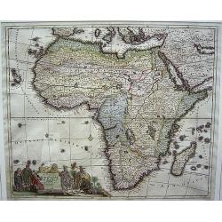
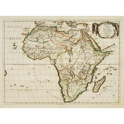
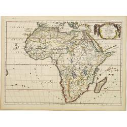
Totius Africae Accuratissima Tabula.
The cartouche is a colorful one with people in varied costumes: Moors, Black Africans, children, and a mounted elephant.Map is framed but can be removed from the frame fo...
Date: Amsterdam, ca. 1690
Selling price: ????
Please login to see price!
Sold
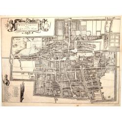
Haga Comitis Vulgo 'sGraven-Hage.
Bird-eye view of the town. Copied after Blaeu. From the rare work by G.Letie. Teatro Belgico.. , printed by Willem de Jonge.RARE.
Date: Amsterdam 1690
Selling price: ????
Please login to see price!
Sold
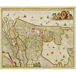
Comitatus Hollandiae tabula pluribus..
West to the top. Lower left inset of the Wadden Islands, Texel, Vlieland, Terschelling and part of Ameland.
Date: Amsterdam 1690
Selling price: ????
Please login to see price!
Sold
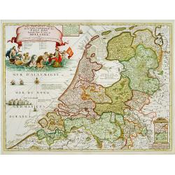
Les Provinces Unies ou la Partie Septentrionale..
RARE map of The Netherlands. A visually stunning map with a large title cartouche. This large one-sheet map was produced by the Venetian cosmographer Vincenzo Coronelli w...
Date: Paris 1690
Selling price: ????
Please login to see price!
Sold
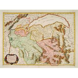
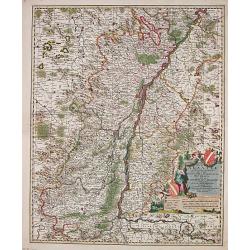
Partie Septentrionale des Estats de Savoye..
Map of Savoy. With original or early outline hand-color. Numerous place-names of counties, cities, towns, physical features. Prepared by N.Sanson.This edition carries the...
Date: Paris 1690
Selling price: ????
Please login to see price!
Sold
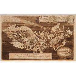
Cometa Anno MDCLXXX e LXXXI observ. Friderico Madeweis Berolini..
A finely engraved map of a Comet observed in 1680 by Frederico Madeweis Barolini.
Date: Germany 1690
Selling price: ????
Please login to see price!
Sold
Totius Alsatiae Novissima Tabula qua simul Sundgovia, Brisigavia, Ortenavia maxima pars Marchionatus Badensis.
Frederik de Wit (1610-98), Amsterdam-based cartographer and publisher of 'Atlas minor', 1670, 'Zee-Atlas', 1675, 'Atlas Major', 1690. Nicolaas Visscher (1618-1679), son o...
Date: Amsterdam, F.de Wit, c.1690
Selling price: ????
Please login to see price!
Sold in 2014
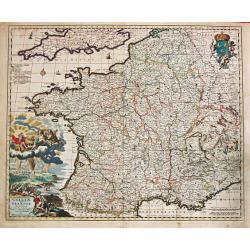
Galliae seu Francia Tabula.
Frederik de Wit (1610-98), Amsterdam-based cartographer and publisher of 'Atlas minor', 1670, 'Zee-Atlas', 1675, 'Atlas Major', 1690.A very attractive map of France. Embe...
Date: Amsterdam, F. de Wit, c.1690
Selling price: ????
Please login to see price!
Sold
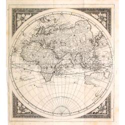
(No title) Eastern Hemisphere.
Uncommon map of the eastern hemisphere with Europe, Africa, Asia and Australia. Text in German and showing two tracks from England and Holland to Indonesia continuing to ...
Date: Germany, c. 1690
Selling price: ????
Please login to see price!
Sold in 2016
Africa Vetus.
A fine map of the African continent.Nicolas Sanson was to bring about the rise of French cartography, although the fierce competition of the Dutch would last until the en...
Date: Paris 1690
Selling price: ????
Please login to see price!
Sold
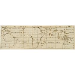
A view of the General & Coasting Trade-Winds in the Atlantic
An uncommon map of the Oceans with its currents and winds between 35degrees North and 35degrees South latitude.To the right Formoso (Taiwan), part of Japan and part of Au...
Date: London c.1690
Selling price: ????
Please login to see price!
Sold
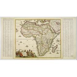
Totius Africae Accuratissima Tabula.
A handsome copy of this skillfully engraved, highly decorative map, including the island of Madagascar. The title cartouche shows native people among which a tribal chief...
Date: Amsterdam, 1690
Selling price: ????
Please login to see price!
Sold
Africa Vetus.
A fine map of the ancient African continent.This edition carries the date 1690 and in brown manuscript in Aedibus Regiis .Nicolas Sanson was to bring about the rise of Fr...
Date: Paris 1690
Selling price: ????
Please login to see price!
Sold
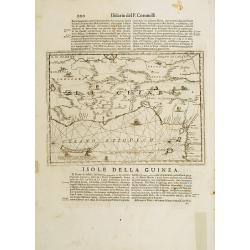
Isola della Guinea. / Isola Gore.
Fine map of Guinea, from Isolario Dell'Atlante Vento.On verso a map of the island Goeree (130x172mm).
Date: Venice 1690
Selling price: ????
Please login to see price!
Sold
![[Globe Gore of the Arabian Sea]](/uploads/cache/17783-250x250.jpg)
[Globe Gore of the Arabian Sea]
Originally engraved to be pasted onto a globe in 1688, this edition was printed with a text underneath it. It shows the Arabian Sea from Oman to Sri Lanka, with a roundel...
Date: Venice 1690
Selling price: ????
Please login to see price!
Sold
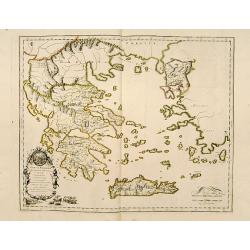
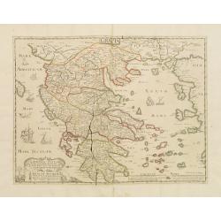
Graeciae Foederata.
A fine map of Ancient Greece.This edition carries the date 1690.Nicolas Sanson was to bring about the rise of French cartography, although the fierce competition of the D...
Date: Paris, 1690
Selling price: ????
Please login to see price!
Sold
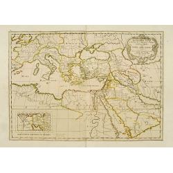
Geographiae Sacrae .. Totius Orbis Partes..
Standard map of the ancient world. Centred on Cyprus. With inset map of Egypt.This edition carries the date 1690.Nicolas Sanson was to bring about the rise of French cart...
Date: Paris 1690
Selling price: ????
Please login to see price!
Sold
Tabula nova Provinciae Ultrajectinae quam jussu Nob: hujus Dominij Ordinum Emensus esat Bernardus du Roy?.
Large and highly detailed map showing the area between Amsterdam, Gouda, Arnheim and Zutphen including Utrecht and Amersfoort. Many towns, streets (some with names!), riv...
Date: Amsterdam, c1690
Selling price: ????
Please login to see price!
Sold
Les Etats de Savoye et de Piemont..
With a panoramic inset view of Chambery, and insets of plans of Yvrée, Montmelian, Nice, Turin, Verrue, Vercelli. Showing the Mediterranean coastline from Antibe, Nice t...
Date: Paris, 1690
Selling price: ????
Please login to see price!
Sold
Paralello geografico dell'antico col moderno Arcipelago ..
A beautiful and rare map showing the Marmara Sea or Sea of Marmora (ancient Propontis), inland sea, north-western Turkey, connected to the Black Sea by the Bosporus Strai...
Date: Venice, 1690
Selling price: ????
Please login to see price!
Sold in 2009
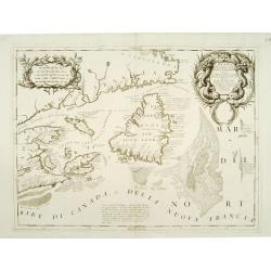
Canada Orientale nell\' America Settentrionale ..
Elaborate map of the Newfoundland, Labrador, Nova Scotia and the Gulf of St. Lawrence. Two ornate cartouches. From Coronelli\'s rare Atlante Veneto, one of the most decor...
Date: Venice 1690
Selling price: ????
Please login to see price!
Sold in 2008
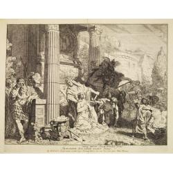
Agamemnon offering his daughter Iphegenia, in honour of the goddess Diana.
De Lairesse drew and cut the plate. Edited by Nicolaas Visscher.
Date: The Netherlands 1650-1690
Selling price: ????
Please login to see price!
Sold
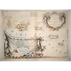
ISOLE AZZORI, O AZZORIDI...
This handsome, elaborate map of the Azores includes a detailed bird's-eye plan of Angra enclosed in an ornate, drape-style cartouche. Coastal towns are named. The beautif...
Date: Venice, c. 1690
Selling price: ????
Please login to see price!
Sold
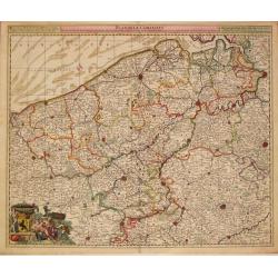
Flandriae Comitatus.
Frederik de Wit (1610-98), Amsterdam-based cartographer and publisher. ' Atlas minor', 1670, ' Zee-Atlas', 1675, ' Atlas Major', 1690.Nicolaas Visscher's attractive map o...
Date: Amsterdam, c.1690
Selling price: ????
Please login to see price!
Sold in 2013
Regionum Coloniensis Electoratu et Archiepiscopatu Tabula.
Nicolaas Visscher's attractive map of Nordrhein-Westfalen. Embellished with a title-cartouch and a cartouche with scales.From Frederick de Wit's' Atlas Maior'. Frederik d...
Date: Amsterdam, F. de Wit, c.1690
Selling price: ????
Please login to see price!
Sold in 2021
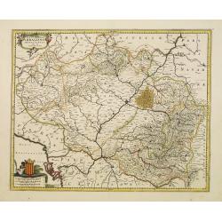
Novissima Arragoniae regni tabula.
Shows cities of Saragossa and Pamplona.
Date: Amsterdam, 1690
Selling price: ????
Please login to see price!
Sold in 2010
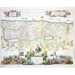
Het Beloofde Landt Canaan...
Very decorative map of Holy Land, showing Jesus Christ and various vignettes with biblical scenes on the bottom. 2 nice cartouches with a key and milage scales. Small shi...
Date: Amsterdam c1690
Selling price: ????
Please login to see price!
Sold
Totius Alsatiae Novissima Tabula qua simul Sundgovia, Brisigavia, Ortenavia maxima pars Marchionatus Badensis.
Frederik de Wit (1610-98), Amsterdam-based cartographer and publisher. ' Atlas minor', 1670, ' Zee-Atlas', 1675, ' Atlas Major', 1690. Nicolaas Visscher (1618-1679), son ...
Date: Amsterdam, F.de Wit, c.1690
Selling price: ????
Please login to see price!
Sold in 2018
Africa Vetus.
A fine map of the ancient African continent. Original outline colors retouched.Nicolas Sanson was to bring about the rise of French cartography, although the fierce compe...
Date: Paris 1690
Selling price: ????
Please login to see price!
Sold
Magnae Tartariae Magni Mogolis Imperii Japoniae et Chinae.
The map stretches from the Caspian Sea in the West to Formosa and Japan in the East. Korea rightly correctly depicted as a peninsula.With decorative title cartouche held ...
Date: Amsterdam 1690
Selling price: ????
Please login to see price!
Sold
Dania Regnum In quo sunt Ducatus Holsatia et Slesvicum..
An attractive map centred on Denmark. Very ornamented title cartouche in the upper right-hand corner.
Date: Amsterdam, 1690
Selling price: ????
Please login to see price!
Sold

Chin Fo Cum Chinois né en la Province de Nankim de parens chrestiens.
Very rare and decorative costume plate. Underneath the plate a descriptive text in French.Bears the address : Aparis Chez Langlois rue St.Jacques a l'Enseigne de la Victo...
Date: Paris, ca. 1690
Selling price: ????
Please login to see price!
Sold

Kam Hi Fils de Chien chi Empereur des Tartares orientaux?.plusieurs titres d'honneur Ecrits de sa propre main.
Very rare and decorative costume plate. Underneath the plate a descriptive text in French.Bears the address : Aparis Chez Langlois rue St.Jacques a l'Enseigne de la Victo...
Date: Paris, ca. 1690
Selling price: ????
Please login to see price!
Sold
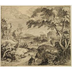
Landscape.
A wooded landscape with a river and fishermen, a castle in the background.Rijsbrack was a pupil of Philips Immenraet in 1672. Was master in Antwerp in 1673, he left for L...
Date: Antwerp ca. 1690
Selling price: ????
Please login to see price!
Sold
Germania Antiqua.
A fine map of ancient Germany, Poland and the Netherlands.This edition carries the date 1690 in manuscript.Nicolas Sanson was to bring about the rise of French cartograph...
Date: Paris, 1690
Selling price: ????
Please login to see price!
Sold in 2010
Graeciae Antiquae.
A fine map of Ancient Greece prepared by Sanson. A later impression of the copper plate as a large crack in the plate is shown.This edition carries the address of Pierre ...
Date: Paris 1690
Selling price: ????
Please login to see price!
Sold
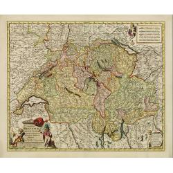
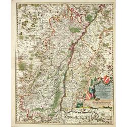
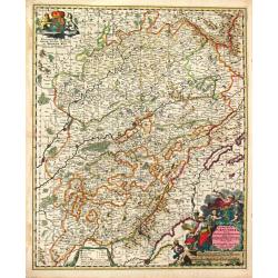
Exactissima Helvetiae Rhaetiae, Valesiae Cieterorumq, Confaederatorum ut et finitimorum Populorum Regionum Tabula.
Very detailed map of Switzerland graphically depicting the mountainous region. Hundreds of tiny villages are named. Decorated with two cartouches, a scale of miles, and a...
Date: Amsterdam, 1690
Selling price: ????
Please login to see price!
Sold in 2009
Novissima et Accuratissima Totius Angliae Scotiae..
Rare issue of Justus Danckert's attractive map of Great-Britain. With the imprint of Justus in place of Theo in the title. The plate is also been retouched in several pla...
Date: Amsterdam, 1690
Selling price: ????
Please login to see price!
Sold in 2013
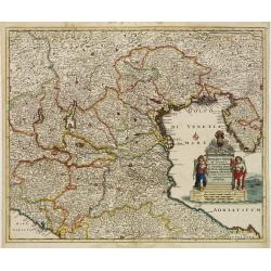
Dominii Veneti in Italia in Partes Accurate..
Rare issue of Cornelis Danckert's attractive map of northern part of Italy, including, Venice, Bologne, Parma, Vicenza, Verona, Ravenna, etc. Decorative title cartouche l...
Date: Amsterdam 1690
Selling price: ????
Please login to see price!
Sold
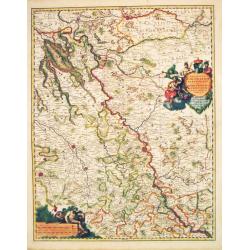
Circulus Franconia in quo sunt Episcopatus Wurtzburg, Bamberg et Aichstet.Ducatus Coburgensis, Marchionatus Cullembach et Onspach Comitatus Henneberg, Wertheim, Holach, Reinec, Papenheim, Erpach, Schwartzenberg, et Castel. Sensheim et Terr. Norinbergense.
Frederik de Wit (1610-98), Amsterdam-based cartographer and publisher. ' Atlas minor', 1670, ' Zee-Atlas', 1675, ' Atlas Major', 1690.An attractive map of the Fränkische...
Date: Amsterdam, c.1690
Selling price: ????
Please login to see price!
Sold in 2010
Moguntini Archipiscopat' et electorat nec non Commitatum Utriusque Cattimeliboci Verhemensis & Erpachiensi.
Nicolaas Visscher's attractive map of the southern part of Rheinland-Pfalz, Hessen and Wertheim. Embellished with a very cartouche.Frederik de Wit (1610-98), Amsterdam-ba...
Date: Amsterdam, F.de Wit, c.1690
Selling price: ????
Please login to see price!
Sold in 2018
Regiae Celsitudinis Sabaudicae Status consistens Sabaudiae ac Montisferrati Ducatus, Pedemontii principatum, nec non Nicaeensem Comitatum.
An attractive map of Savoye. Embellished with a very large title-cartouche in beautiful coloring.From Frederick de Wit's' Atlas Maior'.
Date: Amsterdam, F. de Wit, 1690
Selling price: ????
Please login to see price!
Sold
Carte Particulire du terroir et des Environs de Paris qui est la plus grande partie de L' Isle de France.
Frederik de Wit (1610-98), Amsterdam-based cartographer and publisher. 'Atlas minor', 1670, 'Zee-Atlas', 1675, ' Atlas Major', 1690.Nicolas Visscher's attractive map of I...
Date: Amsterdam, Wit, F. de, 1690
Selling price: ????
Please login to see price!
Sold in 2020
Comitatus Burgondiae.
Frederik de Wit (1610-98), Amsterdam-based cartographer and publisher. ' Atlas minor', 1670, ' Zee-Atlas', 1675, 'Atlas Major', 1690.An attractive map of Burgondy. Embell...
Date: Amsterdam, F. de Wit, c.1690
Selling price: ????
Please login to see price!
Sold in 2014
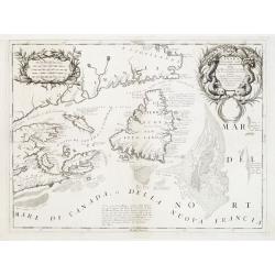
Canada Orientale nell' America Settentrionale ..
Elaborate map of the Newfoundland, Labrador, Nova Scotia and the Gulf of St. Lawrence. Two ornate cartouches. From Coronelli's rare Atlante Veneto, one of the most decora...
Date: Venice 1690
Selling price: ????
Please login to see price!
Sold
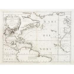
Mare del Nord.
Shows the Atlantic Ocean between Iceland, Europe, West-Africa, Brazil and Canada, including the Caribbean. Here Coronelli splendidly delineates the center of European eco...
Date: Venice 1690
Selling price: ????
Please login to see price!
Sold
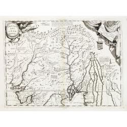
Impero del Gran Mogol.
Northern India, with Pakistan, Bangladesh and the western part of Burma. In the top corners are cartouches for title and dedication, both with a martial theme. Engraved i...
Date: Venice 1690
Selling price: ????
Please login to see price!
Sold
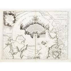
Terre Artiche.
A beautiful and rare map showing the Arctic circle, the northern parts of Canada, Europe and Siberia.A central circular panel of text is surrounded by a glacial frame. Th...
Date: Venice 1690
Selling price: ????
Please login to see price!
Sold
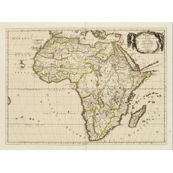
![[2 sheets] L AFRICA divisa nelle sue Parti secondo le pui moderne..](/uploads/cache/23436-250x250.jpg)
[2 sheets] L AFRICA divisa nelle sue Parti secondo le pui moderne..
A beautiful and rare two-sheet map of Africa. The title cartouche is depicted on a drape surrounded by native animals.A most noticeable feature of the decoration on the m...
Date: Venice 1690
Selling price: ????
Please login to see price!
Sold
![[4 sheets] America Settentrionale Colle Nuove Scoperte Sin All Anno 1688](/uploads/cache/23437-250x250.jpg)
[4 sheets] America Settentrionale Colle Nuove Scoperte Sin All Anno 1688
Gorgeous example of Coronelli's famous four- sheet map of America. One of the best examples of California as an island. The map also includes extensive annotations on the...
Date: Venice 1690
Selling price: ????
Please login to see price!
Sold
Xansi, e Xensi, Provincie della Cina..
A beautiful map depicting part of China and showing a stretch of the Great Wall of China. With decorative title cartouche, scale cartouche and a cartouche containing some...
Date: Venice 1690
Selling price: ????
Please login to see price!
Sold