Browse Listings
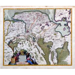
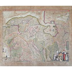
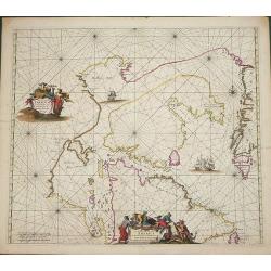
Groningae et Omlandiae dominium vulgo de provincie van Stadt en Lande.
Detailed map of the northern Dutch region of Groningen with a figurative cartouche and coats of arms. The town of Groningen is in the center and Emden is just on the righ...
Date: Amsterdam, ca. 1680
Selling price: ????
Please login to see price!
Sold in 2010
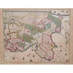
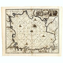
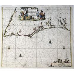
Noordt Hollandt
Map of Noord Holland region, in northern region of The Netherlands, showing cities of Enkhuizen and Medemblick. A variety of ships and sea vessels are depicted in the Mar...
Date: Amsterdam, 1680
Selling price: ????
Please login to see price!
Sold in 2010
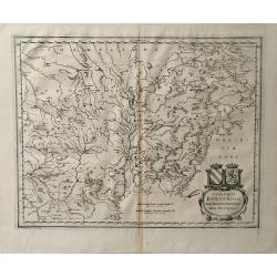
Vtrivsque Burgvndiae Tum Ducatus Tum Comitatus Descriptio.
Map of the Burgundy region of France by Casper Merian from his atlas Topographia Germaniae Inerioris. This wonderfully detailed map depicts major cities such as Toullon, ...
Date: 1680
Selling price: ????
Please login to see price!
Sold in 2010
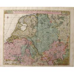
Tabula Geographica qua pars Septentrionalis Sive Inferior Rheni, Mosae, et Mosellae Maximaeque Partes Visorgis, Moeni, Amasi, Scaldis, Isalae, at Alia in Eofdem Influentia Flumina, Necnon, Provinciae Germaniae Inferioris, Westphaliae, Hassiae, Archiepisco
A map depicting the regions between Amsterdam Holland to Frankfurt Germany, which includes major cities such as Munster, Antwerp and Philippville. This wonderfully detail...
Date: Amsterdam, 1680
Selling price: ????
Please login to see price!
Sold in 2010
Carte géographique du duché de Pomeranie et de Mecklenbourg. . .
Decorative map of the provinces of Pomerania and Mecklenburg in Germany. With Lubeck, the island of Rugen, Stettin reaching into modern day's Poland.
Date: Amsterdam, 1680
Selling price: ????
Please login to see price!
Sold in 2011
Constantinopolis.
Rare panoramic of Istanbul published by Frederick de Wit. With a numbered key (1-17) to principal places in town and a poem in Latin, Dutch, English and French.The view ...
Date: Amsterdam, 1680
Selling price: ????
Please login to see price!
Sold in 2023
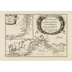
Carte du voyage de Moscovie selon la relation d'Olearius.
Rare map of the region of Baltic sea and the area west of Moscow. With an imposing title cartouche and an inset map "Le cours de l'occa en Moscovie".Basically t...
Date: Paris, 1680
Selling price: ????
Please login to see price!
Sold in 2015
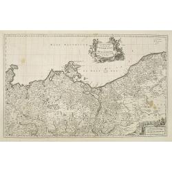
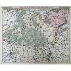
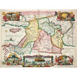
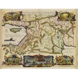
Tabula Frisia, Groninga, et Territorii Emdensis nec non circumjacentium Regionum, puta Transisalaniae, Benthemiae, Westphalae et Oldenburgi
Map of the Friesland and Groningen provinces of northern Holland, including the capital cities of Leeuwarden and Groningen. A beautifully rendered and colored title carto...
Date: Amsterdam, c. 1680
Selling price: ????
Please login to see price!
Sold in 2010
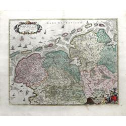
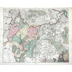
Tabula Dominii Groeningae quae et Complectitur Maximam Partem Drentiae Emendata A.F. De Wit.
Splendid map of the Groningen region of The Netherlands by Frederick de Wit. Small inset maps showing the islands of the region in the top right corner. Shows the cities ...
Date: Amsterdam, 1680
Selling price: ????
Please login to see price!
Sold in 2010
Comitatus Zutphaniae sive Geldriae Tetrachiae Zutphaniensis Isalae Fluvii Correctissima Descriptio denovo revisa, accurate divisa, et edta per F. de Witt
Beautiful map showing the regions of Gelderland, Flevoland and OverIjssel of The Netherlands by Frederick de Wit. The cities of Arnhem, Doesburg, Zutphen, Deventer and Ka...
Date: Amsterdam, c. 1680
Selling price: ????
Please login to see price!
Sold in 2010
Leodiensis Episcopatus Pars Septentrionalis, Comprehendens Comitatum Lossensem et Hornanum
Beautiful map of the Limburg region of Southeastern Netherlands and northern Belgium by Nicolas Visscher. Shows the cities of Maastricht, Hasselt (northern Belgium), Brey...
Date: Amsterdam, c. 1680
Selling price: ????
Please login to see price!
Sold in 2010
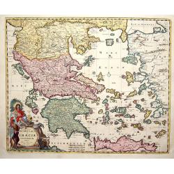
Accurata totius Archipelagi et Graeciae Universae Tabula.
Map of total Greece with all islands.
Date: Amsterdam, 1680
Selling price: ????
Please login to see price!
Sold in 2014
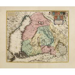
Nova Tabula Magni Ducatus Finlandiae. . .
The map is based on the archetypal map of the Swede Anders Bure. It is the first map to show the Grand-Duchy of Finland on its own. A remarkably beautiful cartouche displ...
Date: Amsterdam, 1680
Selling price: ????
Please login to see price!
Sold in 2010
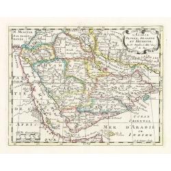
L'Arabie Petrée, Deserte et Hevreuse. . .
An attractive map of the Arabian Peninsula from a French text edition. Engraved by A.de Winter.
Date: Amsterdam, 1680
Selling price: ????
Please login to see price!
Sold
Ungarn, Siebenbürgen, Wallach, Moldau. . .
Rare map of the Danube River. Surrounded by panoramic views of Vienna, Istanbul, Raab, Hermanstat, Temeswar, Gran, etc. Including Istria, and the coast of former Yugoslav...
Date: Nurenberg, c. 1680
Selling price: ????
Please login to see price!
Sold in 2010
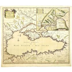
Nouvelle Carte de la Mer Noire et du Canal de Constantinople.
Decorative and uncommon map the Black Sea region. In upper left hand corner an inset map (200x280) of the Bosporus including Istanbul.
Date: Amsterdam, 1680
Selling price: ????
Please login to see price!
Sold in 2011
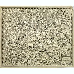
Regnum Hungaria. . .
Centered on Budapest, with Belgrade in the bottom right.
Date: Amsterdam, 1680
Selling price: ????
Please login to see price!
Sold in 2011
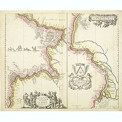
Nova et accurata Wolgae Fluminis olim Rha dicti delineatio Auctore Adamo Oleario.
Showing the Volga River in two parts based on the travels of Adam Olearius. The left side of the map begins at Nazhniy Novgorod and ends at Saratov. The right side contin...
Date: Oxford, 1680
Selling price: ????
Please login to see price!
Sold in 2011
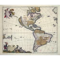
Novissima et Accuratissima Septentrionalis ac Meridionalis Americae...
An attractive, original color map of North and South America.The map was originally based on the Visscher map of 1670 of the Americas. What is especially interesting abo...
Date: Amsterdam, (1670) 1680
Selling price: ????
Please login to see price!
Sold in 2014
Suchuen et Xensi, Provinciae seu Praefecturae Regni Sinensis. . .
Map of the central China provinces of Sichuan and Shaanxi with two cartouches. North orientated to the right.
Date: Amsterdam, c. 1680
Selling price: ????
Please login to see price!
Sold in 2011
Septemtrionaliora Americae a Groenlandia, per Freta Davidis, et Hudson, ad Terram Novam - De Noordelyckste Zee kusten van America van Groenland door de Straet Davis ende Straet Hudson tot Terra Neuf
De Wit's fine of Hudson Bay and Arctic Canada. This includes Hudson Bay and Strait, Baffin Bay and extends to include the western coast of Greenland. The chart shows a s...
Date: Amsterdam, 1680
Selling price: ????
Please login to see price!
Sold in 2014
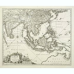
Indiae Orientalis nec non Insularum adiacentium.
Decorative map extending from India in the west, southern Japan in the north and the north coast of Australia is shown at bottom right with some coastal names till Cape Y...
Date: Amsterdam, 1680
Selling price: ????
Please login to see price!
Sold in 2011
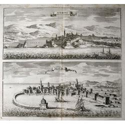
Navarino, Modon.
Two birds- eye town-views on one sheet: Modon and Navarino on the Peloponnese peninsula. Both images show the historically important cities from the seaside with super...
Date: Frankfurt, c1680
Selling price: ????
Please login to see price!
Sold in 2011
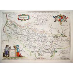
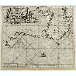
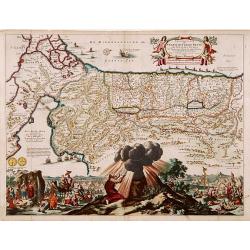
Picardi.
A very well defined map of the Picardi region of France. Two typical regional folk are depicted in the foreground and the royal arms of France are in the top right hand c...
Date: Amsterdam, ca. 1680
Selling price: ????
Please login to see price!
Sold in 2011
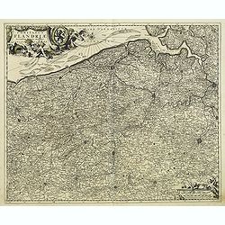
Comitatus Flandriae Accuratissima, descriptio,. . .
Uncommon and detailed map of the provinces of Flanders and Brabant in present-day Belgium.Magnificent title- and scale cartouches etched by Romeijn de Hooghe.
Date: Amsterdam, 1680
Selling price: ????
Please login to see price!
Sold in 2014
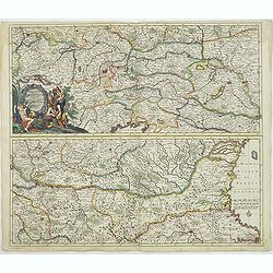
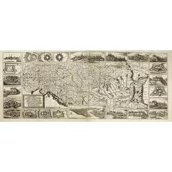
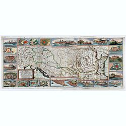
Exactissima Totius DANUBII FLUVII. Tabula et . . .
Two maps on one sheet, showing the course of the River Danube. With Constantinople in the lower right corner. Published by Th. Danckerts. The upper part has a nice origin...
Date: Amsterdam, c.1680
Selling price: ????
Please login to see price!
Sold in 2018
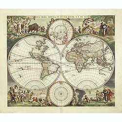
Nova Orbis Tabula in Lucem edita A.F.de Wit.
According to Shirley, De Wit's map is one of the most attractive of its time. The brilliant scenes in the corners combine images of the four seasons, the elements and the...
Date: Amsterdam, 1680
Selling price: ????
Please login to see price!
Sold in 2018
![[Libya] Nieuwe Pascaart voor een Gedeelte van de Zeekusten Van BARBARIA. Beginnende Van C. Mesurata Tot Caap Rusato Als Meede de West-kust van CANDIA. . .](/uploads/cache/83177-250x250.jpg)
[Libya] Nieuwe Pascaart voor een Gedeelte van de Zeekusten Van BARBARIA. Beginnende Van C. Mesurata Tot Caap Rusato Als Meede de West-kust van CANDIA. . .
A beautiful, old colored example of Van Keulen's chart of the coast of Barbaria, from Cape Rusato to Cape Mesurata, from his 'De Nieuwe Groote Lichtende Zee-Fackel, part ...
Date: Amsterdam, ca 1680
Selling price: ????
Please login to see price!
Sold in 2019
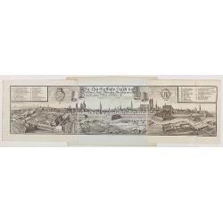
Die Churfürstliche Haubt und Residenz Stadt München, wie solche von Mitternacht gegen Mittag anzusehen ist.
Very decorative and large panoramic view of Munich, published by Michael Wening. Michael Wening (1645-1718) was born in Nuremberg in 1645 as the son of Schweinmetzger Bal...
Date: Nuremberg, 1680
Selling price: ????
Please login to see price!
Sold in 2020
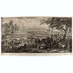
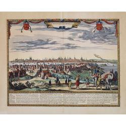
Arrivée du roi devant Douai qu'il fait investir par sa cavalerie
Showing the arrival of Louis XIV arriving near Douai. This fine engraving shows a landscape with, in the foreground, men loading donkeys in the foreground, beyond at left...
Date: Paris, ca. 1680
Selling price: ????
Please login to see price!
Sold in 2021
ROMANIA, THRACE, BULGARIA. -Exactissima Tabula qua tam DANUBII FLUVII PARS INFERIOR, . .
A beautifully colored map depicting the region to the lower reaches of the Danube from Belgrade to the Black Sea. Includes all of Romania, Bulgaria, most of Serbia and Th...
Date: Amsterdam, 1680
Selling price: ????
Please login to see price!
Sold in 2021
Ungarn, Siebenbürgen, Wallach, Moldau. . .
Rare map of the Danube River. Surrounded by panoramic views of Vienna, Istanbul, Raab, Hermanstat, Temeswar, Gran, etc. Including Istria, and the coast of former Yugoslav...
Date: Nurenberg, c. 1680
Selling price: ????
Please login to see price!
Sold in 2020
![[No Title] Mythological Chart.](/uploads/cache/45927-250x250.jpg)
[No Title] Mythological Chart.
A highly decorative and informative chart by Jeremiah Sautter and engraved by Johann Spiegel. This striking engraving depicts the four seasons: Spring with a spade and fr...
Date: Salzburg, ca. 1680
Selling price: ????
Please login to see price!
Sold in 2020
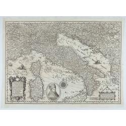
Italiae, Illirici, Sardiniae, Corsicae, et confinium regionum nova et exacta descriptio. Petro Plancio auctore. . .
Very rare map of Italy showing the area between Geneva (Switzerland), Szeged (Ottoman Hungary) and Catania (Sicily), showing patriarchates, archbishoprics and bishoprics,...
Date: Paris / London, c. 1680
Selling price: ????
Please login to see price!
Sold in 2020
![Le Palais Imperial de Iedo [Imperial Palace Tokio]](/uploads/cache/84795-250x250.jpg)
Le Palais Imperial de Iedo [Imperial Palace Tokio]
Very decorative view of the Imperial Palace at Tokio. From : Montanus A., Ambassades Mémorables De La Compagnie Des Indes Orientales Des Provinces Unies Vers Les Empereu...
Date: Amsterdam, 1680
Selling price: ????
Please login to see price!
Sold in 2020
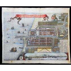
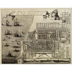
Plan de la Ville…de Batavia / Ware afbeeldinge wegens het Casteel ende Stadt Batavia gelegen opt groot Eylant Java
Very interesting map of Batavia (modern-day Jakarta) as key base in Asia for the Dutch East-Indies Company (VOC). The map shows the city and the surrounding area and is ...
Date: 1680
Selling price: ????
Please login to see price!
Sold in 2021
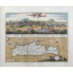
Insula Candia olim Creta.
Superbly engraved and highly beautiful map of Crete, with a large panorama of Heraklion during the Turkish siege on top. The view is very detailed with a number of shi...
Date: Amsterdam, c1680
Selling price: ????
Please login to see price!
Sold in 2023
![[Lot of 3 maps] Tabula Tartariae et Regni China.](/uploads/cache/100353-(2)-250x250.jpg)
[Lot of 3 maps] Tabula Tartariae et Regni China.
Frederick de Wit (1610-1698) became after the closing of the Blaeu firm one of the most important Amsterdam-based publishers. He published several atlases, Atlas Minor (1...
Date: c. 1680
Selling price: ????
Please login to see price!
Sold in 2022
![[Lot of 2 charts and 40 pages of text with prints of coastal profiles] Nieuwe Pascaert vande Oost Cust van Schotlandt Beginnende van Barwyck tot aen de Orcades Ylanden. [Together with a sea-chart of England's east coast.]](/uploads/cache/18507-(1)-250x250.jpg)
[Lot of 2 charts and 40 pages of text with prints of coastal profiles] Nieuwe Pascaert vande Oost Cust van Schotlandt Beginnende van Barwyck tot aen de Orcades Ylanden. [Together with a sea-chart of England's east coast.]
A fine seachart of the east coast of Scotland with the Orkney Islands. Embellished with two cartouches.From the ' Nouveau et Grand Illuminant Flambeau de la Mer'.The succ...
Date: Amsterdam, c. 1680
Selling price: ????
Please login to see price!
Sold in 2022
![[Lot of 11 maps / prints of the United Kingdom.]](/uploads/cache/100251-(1)-250x250.jpg)
[Lot of 11 maps / prints of the United Kingdom.]
An attractive map of the United Kingdom, with an inset map depicting the Orcades and Shetland islands. Embellished with two cartouches.[lot of 11 maps / prints]
Date: Amsterdam, c. 1680
Selling price: ????
Please login to see price!
Sold in 2022
Paskaart Van Cales tot Cadix.
A nautical sea chart of South-Western Europe : part of: England, France, Portugal, Spain, from Dover/Calais to Almeria. Full title in a decorative cartouche at top right ...
Date: Amsterdam, 1681
Selling price: ????
Please login to see price!
Sold in 2021
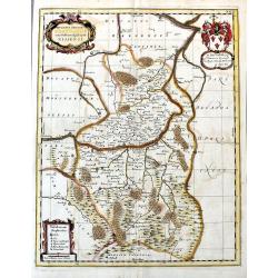
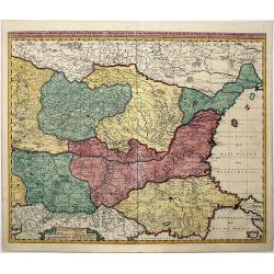
Ducatus Silesiae Grotganus cum Districtu Episcopali Nissensi.
A rare regional map of Poland, centered on the cities of Otmuchów and Nysa in South West Poland near the Czech border. Extends to the North until Brieg. With the title c...
Date: Oxford, 1681
Selling price: ????
Please login to see price!
Sold in 2020
Nieuwe Paskaert, van de Kust van Genehoa als Mede een Gedeelte van Gambia, Beginnende an C. Blanco tot C. Verde…
This sea chart covers the western coast of Africa from Cape Blanco (Ras Nouadhibou) to Cape Verde. The chart depicts the interior course of both the Gambia and Casamance ...
Date: Amsterdam, ca.1681
Selling price: ????
Please login to see price!
Sold in 2023
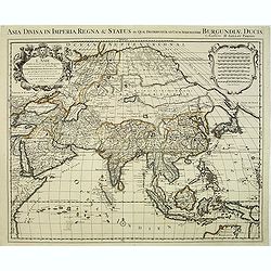
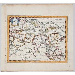
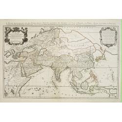
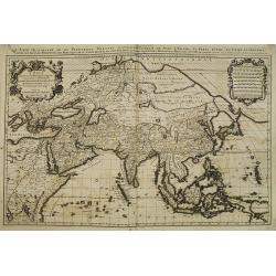
L'Asie divisée en ses principales regions et ou se peuvent voir. . .
One of the largest and most impressive general atlas maps of the Asian continent. Based on Nicolas Sanson's Sr's map of 1650, but Jaillot has updated the north-eastern co...
Date: Paris, 1681
Selling price: ????
Please login to see price!
Sold in 2012

(2 Engravings) Syrien.
Two hand-colored engravings featuring the 17th century fashions of Syrian men. From Dapper's book "Asia, Oder Genaue und Grundliche Beschreibung de Gantzen Syrien un...
Date: Amsterdam, 1681
Selling price: ????
Please login to see price!
Sold in 2016
Die Caspische oder Hyrcanische See.
Strikingly engraved and attractive map of the Caspian Sea, showing major towns, ports, etc. Large decorative cartouche and compass rose. The engraving is neatly executed,...
Date: Nüremberg, Johann Hoffmanns, 1681
Selling price: ????
Please login to see price!
Sold in 2019
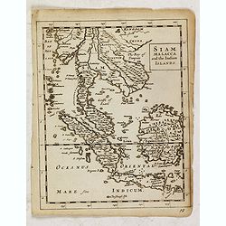
Siam, Malacca and the Indian Islands.
Uncommon map of Siam, Malacca and the Indian Islands, printed by A. Godbid and J. Playford, for R. Scott. Included in "New systeme of the mathematicks: containing . ...
Date: London, 1681
Selling price: ????
Please login to see price!
Sold in 2019
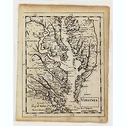
Virginia.
Uncommon map of Virginia, printed by A. Godbid and J. Playford, for R. Scott. Included in "New systeme of the mathematicks: containing . . . II. Practical geometry. ...
Date: London, 1681
Selling price: ????
Please login to see price!
Sold
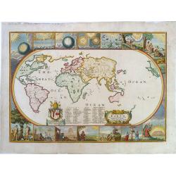
A map of all the Earth and how after the flood it was. . ..
A beautifully colored, and second state of this early and uncommon, oval world map. The map includes CALIFORNIA AS AN ISLAND, and partial coastlines for Japan, Australia...
Date: London, ca.1681
Selling price: ????
Please login to see price!
Sold in 2019
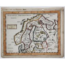
SWEDLAND and NORWAY
A copperplate map of Scandinavia / Baltic from Sir Jonas Moore's "New System of Mathematics" London, Printed by A. Godbid and J. Playford, for Robert Scott, 168...
Date: London, 1681
Selling price: ????
Please login to see price!
Sold in 2019
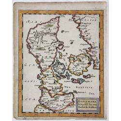
DANEMARK yizt IUTLAND, ZELAND, Sleswick, Holstein
A copperplate map of Denmark from Sir Jonas Moore's "New System of Mathematics" London, Printed by A. Godbid and J. Playford, for Robert Scott, 1681.
Date: London, 1681
Selling price: ????
Please login to see price!
Sold in 2017
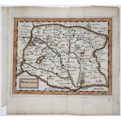
HUNGARIA
A copperplate map of Hungary from Sir Jonas Moore's "New System of Mathematics" London, Printed by A. Godbid and J. Playford, for Robert Scott, 1681.
Date: London, 1681
Selling price: ????
Please login to see price!
Sold in 2017
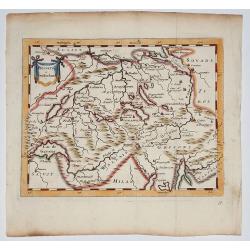
Helvetia (Switzerland) 1681
Copperplate map of Switzerland from Sir Jonas Moore's "New System of Mathematics" London, Printed by A. Godbid and J. Playford, for Robert Scott, 1681
Date: London, 1681
Selling price: ????
Please login to see price!
Sold in 2017
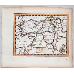
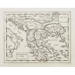
TURQUIE in Asia.
A very rare copperplate map of Asian Turkey from Sir Jonas Moore's "New System of Mathematics" published in London, printed by A. Godbid and J. Playford, for Ro...
Date: London, 1681
Selling price: ????
Please login to see price!
Sold in 2017
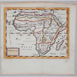
AFRICA.
A copperplate map of Africa from Sir Jonas Moore's "New System of Mathematics" published in London, and printed by A. Godbid and J. Playford, for Robert Scott i...
Date: London, 1681
Selling price: ????
Please login to see price!
Sold in 2019
ASIA.
A copperplate map of Asia from Sir Jonas Moore's "New System of Mathematics"published in London and printed by A. Godbid and J. Playford, for Robert Scott in 16...
Date: London, 1681
Selling price: ????
Please login to see price!
Sold in 2017
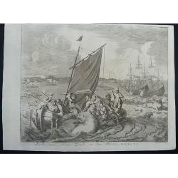
Walrus hunting at Nova Zembla 1596.
This is a fascinating copper engraving that depicts a battle between the crew of a small boat and a large walrus, with ships, polar bears, seals and whales in the backgro...
Date: Amsterdam, 1681
Selling price: ????
Please login to see price!
Sold in 2020
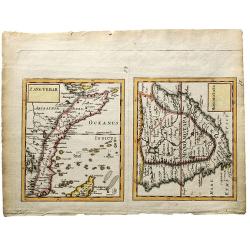
ZANGUEBAR / MONOMOTAPA.
Lovely double miniature maps of Zanzibare and Monomotapa. Todays' Zanzibar in east Africa and Cape of Good Hope in South Africa.
Date: London, 1681
Selling price: ????
Please login to see price!
Sold in 2019
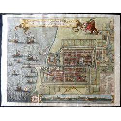
Waere affbeeldinge wegens het casteel ende stadt Batavia.
A large, detailed and finely engraved plan of Batavia, present-day Jakarta, the Dutch center of trading activities in the East Indies. Magnificently engraved by Matheus d...
Date: Amsterdam, 1681
Selling price: ????
Please login to see price!
Sold in 2019
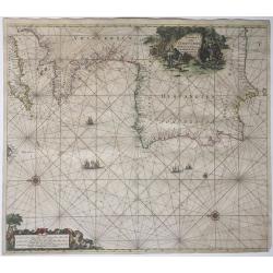
Nieuwe Paskaart, van de Kuste van Reino Do Algarve.
A sea chart of the southern Iberian Peninsula, mainly Portugal, including the coastline of the Algarve and Andalucia, from Cabo San Vincente to Palos. Full title: 'Nieuwe...
Date: Amsterdam, 1681
Selling price: ????
Please login to see price!
Sold in 2021
Waere affbeeldinge wegens het casteel ende stadt Batavia.
A good impression of this finely engraved and detailed plan of Batavia, present-day Jakarta, the Dutch V.O.C. center of trading activities in the East Indies. Copied afte...
Date: Amsterdam, 1681
Selling price: ????
Please login to see price!
Sold in 2011
Nieuwe Paskaert van de kust van Hollandt tussen Texel en..
Sea-chart of the coast of Holland with large decorative cartouche, depicting scenes related to cheese producing.
Date: Amsterdam 1681
Selling price: ????
Please login to see price!
Sold
![[Title page] The English Atlas, volume II.](/uploads/cache/06821-250x250.jpg)
[Title page] The English Atlas, volume II.
Finely engraved title-piece, of the German Emperor and his courtiers, surmounted by the German double-headed eagle, with the arms of the princedoms. At the foot, German s...
Date: Oxford, 1681
Selling price: ????
Please login to see price!
Sold
Pas-kaart van .. Brazilia tusschen I.S.Catharina en..
Johannes Van Keulen's superb chart of the entrance of the Rio de la Plata, including inset chart with the town of Boinos Aires. Published in his Zee-Atlas of 1681 and for...
Date: Amsterdam 1681
Selling price: ????
Please login to see price!
Sold

Daniel Taverniers Land Charte des KönigreichsTUNQUIN.
Covers northern parts Vietnam. From a German edition of Travernier's travel book. According to Cox: Travernier ... Wil always continue among the most valuable travellers ...
Date: Nuremberg 1681
Selling price: ????
Please login to see price!
Sold
L'Asie divisee en ses principales regions et ou se peuvent voir ..
One of the largest and most impressive general atlas maps of the Asian continent. Based on Nicolas Sanson's Sr's map of 1650, but Jaillot has updated the north-eastern co...
Date: Paris, 1681
Selling price: ????
Please login to see price!
Sold
Turquie in Europe.
Extremely rare map of Greece, including also lands adjacent to the Black Sea. From: Jonas Moore, A New Geography with Maps to Each Country. ¤
Date: London, 1681
Selling price: ????
Please login to see price!
Sold
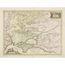
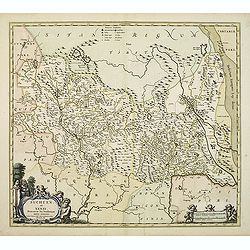
Taurica Chersonesus, Hodie Przecopsca, at Gazara dicitur.
Detailed map of the Ukraine and surrounding regions between the northern coast of the Black Sea and Moscow. Shows ports, fortified cities and the mouths of the Danube. Tw...
Date: Oxford, 1681
Selling price: ????
Please login to see price!
Sold in 2013
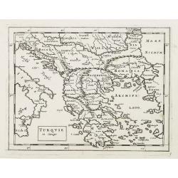
Turquie in Europe.
Extremely rare map of Greece, including also lands adjacent to the Black Sea. From: Jonas Moore, A New Geography with Maps to Each Country, engraved by Herman Moll.
Date: London, 1681
Selling price: ????
Please login to see price!
Sold in 2009
L'Asie divisee en ses principales regions et ou se peuvent voir ..
From the first edition of the Amsterdam pirate edition. One of the largest and most impressive general atlas maps of the Asian continent. Based on Nicolas Sanson's Sr's m...
Date: Amsterdam, 1681
Selling price: ????
Please login to see price!
Sold
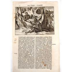
American Family at Rest.
Interesting map of a Native American family at rest. It gives an indication of dress, foods and customs. Olfert Dapper (1635 – 1689) was a Dutch physician and write...
Date: Amsterdam, 1681
Selling price: ????
Please login to see price!
Sold in 2015
![[Title page] The English Atlas, volume II, Tome I.](/uploads/cache/31306-250x250.jpg)
[Title page] The English Atlas, volume II, Tome I.
Title page the English Atlas' of 1681. Finely engraved title-piece, of the German Emperor and his courtiers, surmounted by the German double-headed eagle, with the arms o...
Date: Oxford, 1681
Selling price: ????
Please login to see price!
Sold in 2012
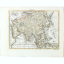
Asia.
Detailed map the Asian continent. The map is of interest for the use of Sea of Corea, the sea between Korea and Japan.
Date: Amsterdam, 1682
Selling price: ????
Please login to see price!
Sold in 2023
Perigrinatie ofte Veertich-Jarige Reyse..
The map is lavishly colored using gold for the title and further embellishment. The figures and decorations are painted in a somewhat impressionistic way. Varnish is used...
Date: Amsterdam, 1682
Selling price: ????
Please login to see price!
Sold in 2011

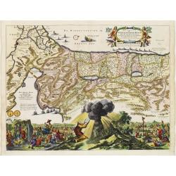
De Gelegentheyt van t' Paradys en t' Landt Canaan, mitsgaders d' eerst bewoonde Landen der Patriarchen.
Dutch so-called "Staten" bibles, published between 1637 and c. 1760, contained 5 maps: The World, "Paradise", The Perigrinations, The Promised Land Ca...
Date: Amsterdam, H. Keur en M. Doornick, ca.1682
Selling price: ????
Please login to see price!
Sold
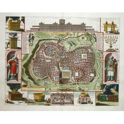
Jerusalem.
Great bird's eye plan of the holy city flanked by engravings of religious icons, and two priests. At the top is a large elevation of the Temple of Solomon and at bottom i...
Date: Amsterdam 1682
Selling price: ????
Please login to see price!
Sold
De Gelegentheyt van t' Paradys en t' Landt Canaan, mitsgaders d' eerst bewoonde Landen der Patriarchen.
Dutch so-called ' Staten' bibles, published between 1637 and c. 1760, contained 5 maps: The World, ' Paradise', The Perigrinations, The Promised Land Canaan, The Travels ...
Date: Amsterdam, H. Keur en M. Doornick, 1682
Selling price: ????
Please login to see price!
Sold in 2020
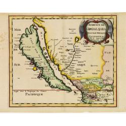
Audience de Guadalajara nouveau Mexique, Californie. &c.
From Sanson's Geographia Exactissima. A finely re-engraved Amsterdam version of Sanson's map of California and New Mexico, first published in 1657, which was the earliest...
Date: Amsterdam 1682
Selling price: ????
Please login to see price!
Sold
De gelegentheyt van 't Paradys en de 't Landt Canaan..
A finely engraved map of the Middle East from the Mediterranean, including Cyprus, eastwards to Syria and Iraq.At the four corners are insets showing the temptation of Ev...
Date: Amsterdam 1682
Selling price: ????
Please login to see price!
Sold
Perigrinatie ofte Veertich-Jarige Reyse..
An attractive map of present-day Israel, also parts of Jordan and Egypt, illustrating the exodus of the Children of Israel crossing the Red Sea.Three dramatic episodes ar...
Date: Amsterdam 1682
Selling price: ????
Please login to see price!
Sold