Browse Listings
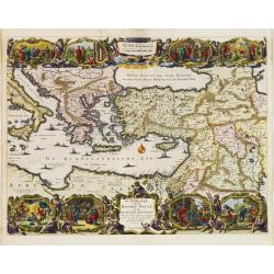
De Beschrijvingh van de Reysen Pauli..
Decorative map with 8 insets depicting the wanders of Paulus and the Apostles. Dutch text on verso. Covers the territory from Sicily in the Mediterranean Sea to the Persi...
Date: Amsterdam 1682
Selling price: ????
Please login to see price!
Sold
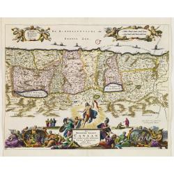
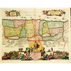
Het Beloofde Landt Canaan..
Decorative map of the Holy Land depicting the twelve tribes of Israel.Elaborate, engraving along the bottom of the map depicts the Apostles, a Nativity scene, the Crucifi...
Date: Amsterdam 1682
Selling price: ????
Please login to see price!
Sold
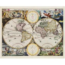
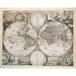
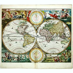
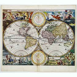
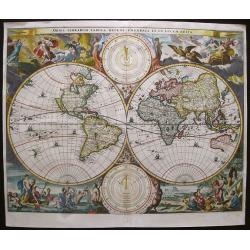
Orbis Terrarum Tabula recens emendata et in Lucem edita.
Beautiful double hemisphere world map from a folio Dutch Bible published by Hendrik and Jacob Keur.Surrounded by fabulous scenes from the Visscher-Berchem map of 1658 wit...
Date: Amsterdam 1682
Selling price: ????
Please login to see price!
Sold
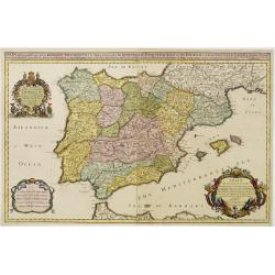
SPAIN distinguisht into all its Kingdoms..
With three very fine cartouches. With dedication to Charles II. Very detailed and scarce map of Spain, Portugal, Majorca, Minorca and Ibizza.William Berry was an well-kno...
Date: London 1682
Selling price: ????
Please login to see price!
Sold
Het Beloofde Landt Canaan door wandelt van onsen Salichmaecker Iesu Christo, neffens syne Apostelen.
Dutch so-called "Staten bibles", published between 1637 and c. 1760, contained 5 maps: The World, "aradise", The Perigrinations, The Promised Land Can...
Date: Amsterdam, 1682
Selling price: ????
Please login to see price!
Sold in 2010
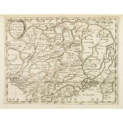
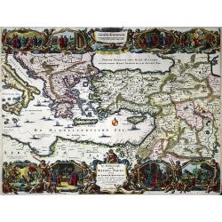
T\'Ryk van den Grooten Mogol.
An attractive map of northern India, and inner Asia, published by F.Halma.
Date: Utrecht, 1682
Selling price: ????
Please login to see price!
Sold in 2010
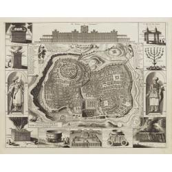
Jerusalem
Plan of ancient Jerusalem from a Dutch bible. At the top the Temple as a Renaissance palace, at left and right Biblical figures and Temple vessels.
Date: Amsterdam, 1682
Selling price: ????
Please login to see price!
Sold
Orbis Terrarum Tabula. . .
Double hemisphere world map from a folio Dutch Bible published by Hendrik and Jacob Keur.Surrounded by fabulous scenes from the Visscher-Berchem map of 1658 with astronom...
Date: Amsterdam, 1682
Selling price: ????
Please login to see price!
Sold in 2014
Caerte vande Cabo de Bona Esperança / En haer gelegentheyt daer omtrent.
Rare first state, 1682, showing the first land grants, with J.N. in the cartouche. An early Dutch map of the Cape of Good Hope map which first appeared in Johan Nieuhoff\...
Date: Amsterdam, 1682
Selling price: ????
Please login to see price!
Sold in 2008
De cust van Barbaria
A sea chart depicting the west coast of Africa.Doncker ran a flourishing business in Amsterdam as a bookseller and publisher of sea atlases and textbooks on navigation. D...
Date: Amsterdam, 1682
Selling price: ????
Please login to see price!
Sold in 2010
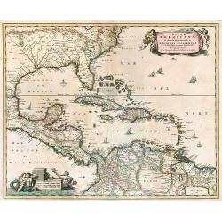
Insulae Americanae in Oceano Septentrionali ac Regiones Adiacentes.
A beautiful map that includes the American Southeast, part of Mexico, Central America, and the northern part of South America. Two cartouches with cherubs and mermaids de...
Date: Amsterdam, 1682
Selling price: ????
Please login to see price!
Sold in 2009
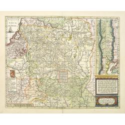
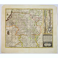
Magni ducatus Lithuaniae Caeterarumq Regionum illi adiacentium exacta descrip. . .
Highly detailed map of Lithuania including the inset of the Dnieper River, based upon Blaeu's four sheet map. Highly detailed, extending from Cracow to the Baltic in the ...
Date: Oxford, 1682
Selling price: ????
Please login to see price!
Sold in 2010

Flandriae Partes duae, quarum altera proprietaria, altera imperialis. . .
No text on verso.! A very detailed map with Gent in the center. Lower right corner Antwerp and Vlissingen in top right. At bottom left a very decorative cartouche with a ...
Date: Oxford, 1682
Selling price: ????
Please login to see price!
Sold in 2011
Orbis Terrarum Tabula. . .
Beautiful double hemisphere world map from a folio Dutch Bible published by Hendrik and Jacob Keur.Surrounded by fabulous scenes from the Visscher-Berchem map of 1658 wit...
Date: Amsterdam, 1682
Selling price: ????
Please login to see price!
Sold in 2012
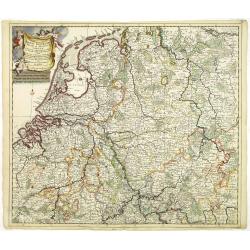
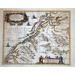
Accuratissima Rheni Inferioris Mosae et Mosellae tabula. . .
Danckerts' scarce map of the rivers Rhine, Maas and Waal. Including, Belgium, Luxemburg and large part of Germany.
Date: Amsterdam, 1682
Selling price: ????
Please login to see price!
Sold in 2011
De beschryvingh van de reysen Pauli ..
Nice decorative map with eight vignettes with episodes from the travels of St. Paul, including 64 numbered references on the map.
Date: Amsterdam, 1682
Selling price: ????
Please login to see price!
Sold in 2020
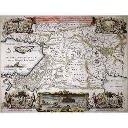
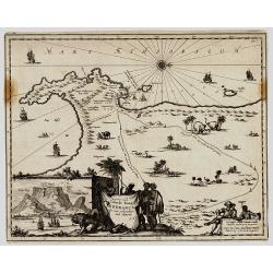
De gelegentheyt van 't Paradys en 't Landt Canaan mitsgaders d'eerst bewoonde Landen de Patriarchen.
Shows the Middle East from Assyria to the Mediterranean Sea. Shows also the route taken by Abraham from Ur to Haran. Vignettes show Adam in Paradise with various animals,...
Date: Amsterdam, 1682
Selling price: ????
Please login to see price!
Sold in 2020
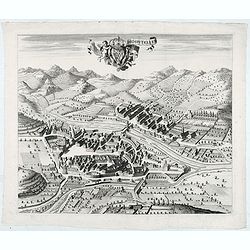
(Annecy) Annessium vulgo Annessy.
Showing in great detail a bird's-eye view of the city of Annecy, decorated with the coat of arms of the Duchy of Savoy carried by angels. In bottom numbered key.From &quo...
Date: Amsterdam, 1682
Selling price: ????
Please login to see price!
Sold in 2020
![Moustiers. [Moûtiers]](/uploads/cache/45418-250x250.jpg)
Moustiers. [Moûtiers]
Showing in great detail a bird's-eye view of the city of Moûtiers, decorated with the coat of arms of the Duchy of Savoy hold by angels. In bottom lettered key.From &quo...
Date: Amsterdam, 1682
Selling price: ????
Please login to see price!
Sold in 2020
![Abbaye d'Hautecombe. [Hautecombe Abbey]](/uploads/cache/45420-250x250.jpg)
Abbaye d'Hautecombe. [Hautecombe Abbey]
Showing in great detail a bird's-eye view of the Hautecombe Abbey, a former Cistercian monastery, later a Benedictine monastery, in Saint-Pierre-de-Curtille near Aix-les-...
Date: Amsterdam, 1682
Selling price: ????
Please login to see price!
Sold in 2020
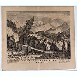
Le Grand Chemin Royal de la Crote.
Showing in great detail a bird's-eye view of Le Grand Chemin Royal de la Crote. In bottom a lettered key.From "Theatrum Sabaudiæ". Engraved by Johannes de Ram ...
Date: Amsterdam, 1682
Selling price: ????
Please login to see price!
Sold in 2020
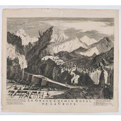
Le Grand Chemin Royal de la Crote.
Showing in great detail a bird's-eye view of Le Grand Chemin Royal de la Crote. In bottom a lettered key.From "Theatrum Sabaudiæ". Engraved by Johannes de Ram ...
Date: Amsterdam, 1682
Selling price: ????
Please login to see price!
Sold in 2021
![Moustiers. [Moûtiers]](/uploads/cache/45507-250x250.jpg)
Moustiers. [Moûtiers]
Showing in great detail a bird's-eye view of the city of Moûtiers, decorated with the coat of arms of the Duchy of Savoy hold by angels. In bottom lettered key.From &quo...
Date: Amsterdam, 1682
Selling price: ????
Please login to see price!
Sold in 2020
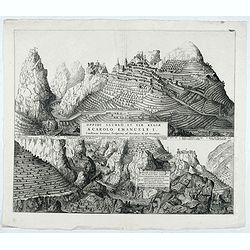
Oppidi Saurgii et viae Regiae a Carolo Emanuele I.
Showing in great detail a bird's-eye view of the city of Saorge, located in Alpes Maritimes in France.From "Theatrum Sabaudiæ". Engraved by Johannes de Ram.Joa...
Date: Amsterdam, 1682
Selling price: ????
Please login to see price!
Sold in 2021
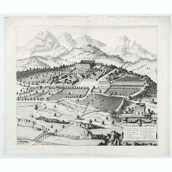
Villarium Oppidu.
Showing in great detail a bird's-eye view of the city of Villar sur Var, located in near from Nice.From "Theatrum Sabaudiæ". Engraved by Johannes de Ram.Joan B...
Date: Amsterdam, 1682
Selling price: ????
Please login to see price!
Sold in 2022
Hospitelum.
Showing in great detail a bird's-eye view of the city of Sospel, located in near from Nice and Monaco.From "Theatrum Sabaudiæ". Engraved by Johannes de Ram.Joa...
Date: Amsterdam, 1682
Selling price: ????
Please login to see price!
Sold in 2022
![Rupes Allobrogum vulgo La Roche.. [La Roche]](/uploads/cache/45944-250x250.jpg)
Rupes Allobrogum vulgo La Roche.. [La Roche]
Showing in great detail a bird's-eye view of the city. From "Theatrum Sabaudiæ". Engraved by Conraet Decker.Joan Blaeu published during his life three town-boo...
Date: Amsterdam, 1682
Selling price: ????
Please login to see price!
Sold in 2020
![[Fossano] Delinea Civitatis Fossani In Principatu Pedemontii](/uploads/cache/45946-250x250.jpg)
[Fossano] Delinea Civitatis Fossani In Principatu Pedemontii
Showing in great detail a bird's-eye view of Fossano, in the Piedmont region of Northern Italy. From "Theatrum Sabaudiæ". Engraved by J. de Ram.Joan Blaeu publ...
Date: Amsterdam, 1682
Selling price: ????
Please login to see price!
Sold in 2020
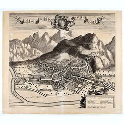
Civitas Sancti Joannis Maurianensis. (Saint Jean de Maurienne)
Showing in great detail a bird's-eye view of the town of Saint Jean de Maurienne in the Savoy region of the French Alps. From "Theatrum Sabaudiæ". Joan Blaeu p...
Date: Amsterdam, 1682
Selling price: ????
Please login to see price!
Sold in 2020
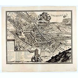
Chamberium Chambery
Showing in great detail a bird's-eye view of the city of Chambery, decorated with the coat of arms of the Duchy of Savoy hold by angels. In bottom lettered key.From "...
Date: Amsterdam, 1682
Selling price: ????
Please login to see price!
Sold in 2020
![[Title page] Atlas Minor sive totius Orbis Terrarum. . .](/uploads/cache/47918-250x250.jpg)
[Title page] Atlas Minor sive totius Orbis Terrarum. . .
Finely etched frontispiece together with the printed title page from Visscher's Atlas Minor. Showing Atlas supporting the World, and Neptune seated astride a terrestrial...
Date: Amsterdam, 1682
Selling price: ????
Please login to see price!
Sold in 2022
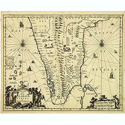
Landt caert vande Malabaer, Madura en Cormendel.
Detailed map of the southern tip of India and a part of Sri Lanka from Joan Nieuhof, "Gedenkwaerdige zee- en lantreize. . ."Decorative cartouches in the lower l...
Date: Amsterdam, 1682
Selling price: ????
Please login to see price!
Sold in 2012
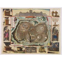
Jerusalem.
Engraved by Bastiaan Stoopendaal from Juan Bautista Villapando's imaginary "carte à figures"- plan of Jerusalem. This bird's-eye view is surrounded by 12 scene...
Date: Amsterdam, 1682
Selling price: ????
Please login to see price!
Sold in 2020
Dioecesis Trundhemiensis pars Australis.
From his "Atlas major, sive, Cosmographia universalis, adeoque orbis terrestris, maritimus, antiquus & coelestis : in quo tabulae cum descriptionibus omnium regi...
Date: Oxford, 1682
Selling price: ????
Please login to see price!
Sold in 2014
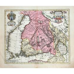
Magnus Ducatus Finlandiae nova et accurata delineatio.
Very decorative, large map depicting part of the Scandinavian countries, Russia, Finnland. With two decorative cartouches with dedication to J.Schütz. Partly colored usi...
Date: Oxford, 1682
Selling price: ????
Please login to see price!
Sold in 2012
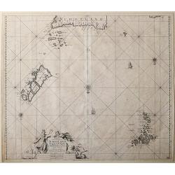
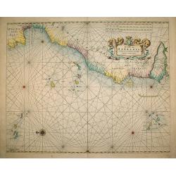
Paskaart vande Noord Cust van Schotland als mede de Eylanden van Hitlandt en Fero.
Sea chart of Northern Scotland with the Orkney islands, the Shetland Islands and the Faroe Islands, oriented to the South.From: De Nieuwe Groote Lichtende Zee-Fakkel, .....
Date: Amsterdam, 1682
Selling price: ????
Please login to see price!
Sold in 2014
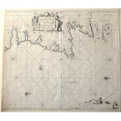
Nieuwe Pascaert van de oost cust van Schotlandt beginnende van Barwyck tot aen de Orcades Ylanden.
Sea chart of the east coast of Scotland, oriented to the West. With engraved plate number 18.
Date: Amsterdam, 1682
Selling price: ????
Please login to see price!
Sold in 2013
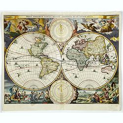
Orbis Terrarum Tabula recens emendata et in Lucem edita.
Beautiful double hemisphere world map from a folio Dutch Bible published by Hendrik and Jacob Keur.Surrounded by fabulous scenes from the Visscher-Berchem map of 1658 wit...
Date: Amsterdam, 1682
Selling price: ????
Please login to see price!
Sold in 2013
Cuneum vulgo Coni.
A beautifully engraved and richly decorated bird's-eye view of Cuneo with the river Stura in the foreground. Blaeu used the work of BORGONIO Giovanni Tommaso Borgonio (16...
Date: Amsterdam, 1682
Selling price: ????
Please login to see price!
Sold in 2014

La Géographie Universelle contenant.
Edition unknown to Pastoureau.
Date: Paris, l'Auteur et Nicolas Langlois, 1682
Selling price: ????
Please login to see price!
Sold
Orbis Terrarum Tabula Recens Emendata et in Lucem Edita
A beautiful double hemisphere world map from a folio Dutch Bible, published by Hendrik and Jacob Keur.
Date: Dordrecht, 1682
Selling price: ????
Please login to see price!
Sold in 2016
Varsovia.
View of Warsaw after Braun and Hogenberg, published in "Toonel der vermaarste Koop-Steden".
Date: Amsterdam, 1682
Selling price: ????
Please login to see price!
Sold in 2017
Segusium prima ab alpibus cotiis civitas.
Splendid city view of Susa, a small city west of Turin near the French border. The view was included in the fourth volume of the town book of Italy, published by the heir...
Date: Amsterdam, ca. 1682
Selling price: ????
Please login to see price!
Sold in 2018
Orbis Terrarum Tabula recens emendata et in Lucem edita.
Beautiful double hemisphere world map from a folio Dutch Bible published by Hendrik and Jacob Keur.Surrounded by fabulous scenes from the Visscher-Berchem map of 1658 wit...
Date: Amsterdam, 1682
Selling price: ????
Please login to see price!
Sold in 2020
Magni ducatus Lithuaniae Caeterarumq Regionum illi adiacentium exacta descrip. . .
Highly detailed map of Lithuania including the inset of the Dnieper River, based upon Blaeu's four sheet map. Highly detailed, extending from Cracow to the Baltic in the ...
Date: Oxford, 1682
Selling price: ????
Please login to see price!
Sold in 2017
La Géographie Universelle contenant. Les Descriptions, les cartes, et le Blason, des principaux Païs du Monde.
Rare pocket atlas of the world by Pierre Duval with the maps in original outlines colors (except for the China map) and the coats-of-arms and titles-pages beautifully emb...
Date: Paris, l'Auteur et Nicolas Langlois, 1682
Selling price: ????
Please login to see price!
Sold in 2017
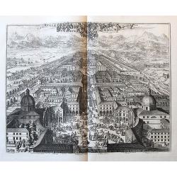
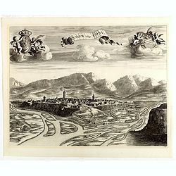
Regiae Venationis Aedium Prospectus.
Splendid city view of Turin, which was probable engraved by Romeyn de Hooghe (1645-1708). The view was included in the fourth volume of the town book of Italy, published ...
Date: Amsterdam, ca. 1682
Selling price: ????
Please login to see price!
Sold in 2018
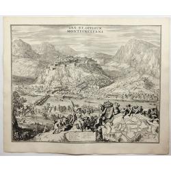
Arx et Oppidum Montismeliani.
A prospect of Montmélian, a fortress guarding the stategic bridge over the Isère River, with an inset plan of the fortress walls. It is in the Auvergne-Rhône-Alpes reg...
Date: Amsterdam, 1682
Selling price: ????
Please login to see price!
Sold in 2018
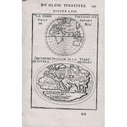
La Terre Partageeaux Trois Enfans de Noe / Ancienne Division dela Terre Endiuers Peuples Du Globe Terrestre.
An attractive miniature map of the Eastern Hemisphere and an oval map show the world known to the ancients. From the French text edition of "Description d'Univers.. ...
Date: Paris, 1683
Selling price: ????
Please login to see price!
Sold in 2014
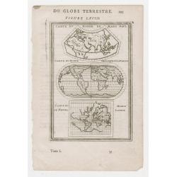
Carte du Monde de Marc Paul. - Carte du Monde de lacques Castaldo. - Carte du de Migued - Monde Lopez....Du Globe Terrestre Allain Manneson Mallet
This map shows various world maps based on early cartographers. From the French text edition of "Description d'Univers."
Date: Paris, 1683
Selling price: ????
Please login to see price!
Sold in 2013
Canada ou Nouvelle France. (together with) United States.
A strange early depiction of the Eastern Seaboard, from Terres Arctiques Incognues to Virginie, including also an outline of the Great Lakes. Native Indians appear at the...
Date: Paris, 1683
Selling price: ????
Please login to see price!
Sold in 2012
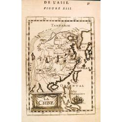
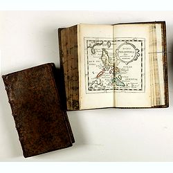
La Chine.
A charming small map of China, Taiwan, the Philippines, Korea, and Kyushu (Japan). From the original French text edition of "Description d'Univers..." by Allain...
Date: Paris, 1683
Selling price: ????
Please login to see price!
Sold in 2012
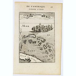
Isles Lucayes.
Fine map showing the Bahamas. The map is inserted in a prospective view of the Caribbean Sea, where some vessels are involved in a naval combat. Part of Cuba and Florida ...
Date: Paris, 1683
Selling price: ????
Please login to see price!
Sold in 2014
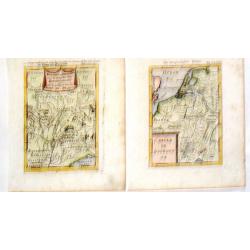
Royaume de Bourgogne Sous la Race des Roys & Cercle de Bourgogne.
Pair of Mallet maps featuring the Bourgogne region of France including Provence, Lombardie, Savoy, Champagne etc. Each has an appropriate cartouche.Alain Manesson Mallet ...
Date: Paris, 1683
Selling price: ????
Please login to see price!
Sold in 2015
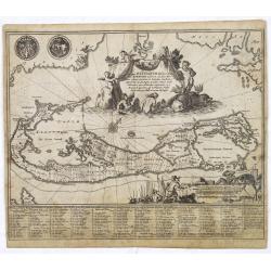
Mappa Aestivarum Insularum alias Barmudas. . .
A very decorative map. The large title cartouche shows Neptune with mermaids and a sea-monster.The map includes the arms of England and Bermuda, and lists proprietors of ...
Date: Amsterdam, 1683
Selling price: ????
Please login to see price!
Sold
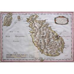
Les Isles de Malte, Goze, &c...
With an elegant title cartouche by one of the great early cartographers.
Date: Paris, 1683
Selling price: ????
Please login to see price!
Sold in 2013
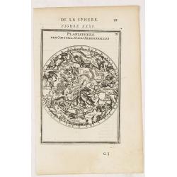
Planisphere des Constellations Meridionalles. Figure XXXV.
A fine celestial chart depicting the southern constellations in allegorical form.From the French text edition of Description d'Univers.. (5 volumes), 1683. By Allain Mann...
Date: Paris, 1683
Selling price: ????
Please login to see price!
Sold in 2022
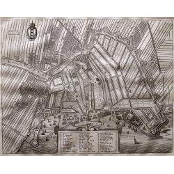
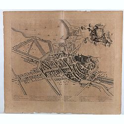
Amsterdam Gelijck die geweest is tot den irae 1658.
Rare town plan of Amsterdam. Embellished with the coat of arms and a cartouche holding the index key. Very detailed plan showing buildings, canals, streets, windmills, fi...
Date: Amsterdam, 1663-1683
Selling price: ????
Please login to see price!
Sold in 2015

(Shipping - Noms des principales Voiles d'un Navire)
Finely etched depiction of a vessel, with a lettered key. With on verso an explanation of the various parts of the vessel. (Noms des principales Voiles d'un Navire).From ...
Date: Paris, 1683
Selling price: ????
Please login to see price!
Sold in 2018
![[8 text pages with coastal views] Des Côtes Maritimes d' Italie, entre Piombino & l' Estroit de Messine avec la Coste Septentrionale, Meridionale & Orientale de l' Isle de Sicile.](/uploads/cache/100210-250x250.jpg)
[8 text pages with coastal views] Des Côtes Maritimes d' Italie, entre Piombino & l' Estroit de Messine avec la Coste Septentrionale, Meridionale & Orientale de l' Isle de Sicile.
Description of the coasts of Italy from Piobino southwards and of Corsica. With small charts within the text of Palermo, the Strait of Messina, Sergento, Saragossa, Messi...
Date: Amsterdam, 1683
Selling price: ????
Please login to see price!
Sold in 2018
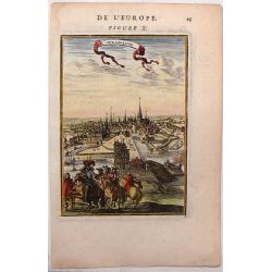
Paris.
Charming and early view of Paris from the book by Christoph Riegel, Ausführliche und grundrichtige Beschreibung deß Königreichs Franckreich, published in Frankfurt and...
Date: Frankfurt and Leipzig, 1683
Selling price: ????
Please login to see price!
Sold in 2014
Copenhague, City View of Copenhagen, Denmark
Nice little city view map of Copenhagen by Mallet from 1683. Hand-colored copper engraving.
Date: Paris, 1683
Selling price: ????
Please login to see price!
Sold in 2016
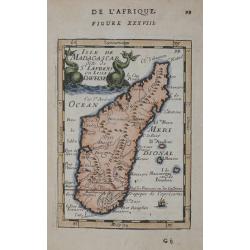
Isle de Madagascar dite de St Laurens ou L'isle Daufine.
Copper engraved map shows the Island of Madagascar. from Mallet's "Description de l'Univers" 1st edition. Blank verso.
Date: Paris 1683
Selling price: ????
Please login to see price!
Sold in 2014
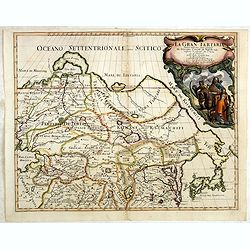
La Gran Tartaria divisa nelle sue parti pricipali da Giacomo
In upper right hand corner a large title cartouche with dedication to Tavernier and Thévenot. The cartographer was Giacomo Cantelli (1643-1695) who was active in Modena ...
Date: Rome, 1683
Selling price: ????
Please login to see price!
Sold in 2014
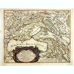
Tartaria D Europa ouero Piccola Tartaria divisa da Giacomo Cantelli da Vignola ne Tartari Nogai e del Crim, o di Precop . . .
Rare map of the Ukraine, Georgia, Muscovy, Southeastern Poland / Lithuania and the Black Sea. With an ornate allegorical cartouche.The cartographer of this map is Giacomo...
Date: Rome, 1683
Selling price: ????
Please login to see price!
Sold in 2022
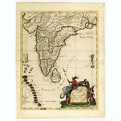
Penisola dell India di là dal Gange. . .
Giacomo Rossi's fine late 17th century map of India and Ceylon. Issued in Il Mercurio geografico In lower right hand corner a large title cartouche.The cartographer was G...
Date: Rome, 1683
Selling price: ????
Please login to see price!
Sold in 2015
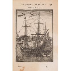
Vaisseau.
Miniature view of a vessel, showing its various corposants. With key list on verso.From the French text edition of Description d'Univers.. (5 volumes), 1683. By Allain Ma...
Date: Paris, 1683
Selling price: ????
Please login to see price!
Sold in 2020
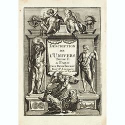
(Title page) Description de L'Univers Tome I. . .
Finely etched title page.From the French text edition of Description d'Univers.. , published in 5 volumes in 1683 by Allain Manneson Mallet (1630-1706), a well travelled ...
Date: Paris, 1683
Selling price: ????
Please login to see price!
Sold in 2015
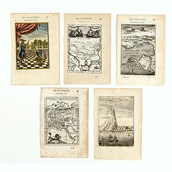
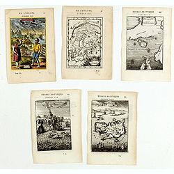
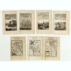
(Five engravings of European interest from Description de l\'Univers)
Finely etched prints and maps.From the French text edition of Description d'Univers.. , published in 5 volumes in 1683 by Allain Manneson Mallet (1630-1706), a well trave...
Date: Paris, 1683
Selling price: ????
Please login to see price!
Sold in 2015
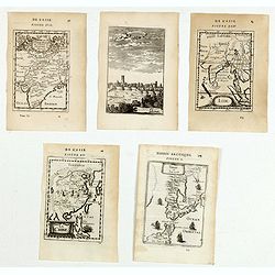
(Five engravings of Asian interest from Description de l\'Univers)
Finely etched prints and maps entitled : Terre de Iesso, La Chine, Inde, Visapor, Partie de la Terre Ferme de L'Inde ou L'Empire du Mogol. From the French text edition of...
Date: Paris, 1683
Selling price: ????
Please login to see price!
Sold in 2015
(Five engravings of Scandinavian interest from Description de l\'Univers)
Finely etched prints and maps, entitled : Islande, Isle d'Islande, Suede, Decowerte de la Groenlande, Norvvegiens. From the French text edition of Description d'Univers.....
Date: Paris, 1683
Selling price: ????
Please login to see price!
Sold in 2015
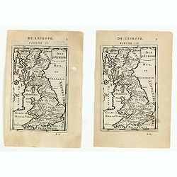
(Two maps) Isle d\'Albion.
Finely etched map of the British Isles (figure II and Figure III.) From the French text edition of Description d'Univers.. , published in 5 volumes in 1683 by Allain Mann...
Date: Paris, 1683
Selling price: ????
Please login to see price!
Sold in 2015
(Five engravings of Caribbean interest from Description de l\'Univers)
Finely etched maps entitled : Le plan de l'Isle de St Jan de P.to Rico, Hispagonla et P. Rico, I. de cuba et de Jamaica, Isles Caraibes, Isles Caraibes". From the Fr...
Date: Paris, 1683
Selling price: ????
Please login to see price!
Sold in 2015
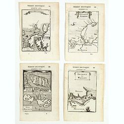
(Four engravings of Russian interest from Description de l\'Univers)
Finely etched maps entitled Spitzberg et N. Zemble, Nouvelle Zemble, Isle des Etats Staten-Eyland, Detroit de waigats. From the French text edition of Description d'Unive...
Date: Paris, 1683
Selling price: ????
Please login to see price!
Sold in 2015
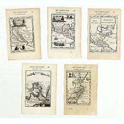
(Five maps of North American interest from Description de l'Univers)
Finely etched maps entitled : Nouveau Mexique et Californie, Mexique et nouvelle Espagne, Amerique Septentrionale, De l'Amerique, Groenlande".From the French text ed...
Date: Paris, 1683
Selling price: ????
Please login to see price!
Sold in 2015
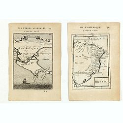
(Two engravings of South American interest from Description de l'Univers)
Finely etched maps entitled "Detroit de Magelan" and "Bresil".From the French text edition of Description d'Univers.. , published in 5 volumes in 1683...
Date: Paris, 1683
Selling price: ????
Please login to see price!
Sold in 2015
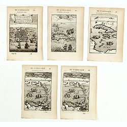
(Nine engravings of African interest from Description de l'Univers)
Nine (on seven sheets) of finely etched prints and maps of African subjects. Engravings and maps entitled - Cap de bone Esperance/Isle de St. Helene, Egypte Ancienne, Con...
Date: Paris, 1683
Selling price: ????
Please login to see price!
Sold in 2015
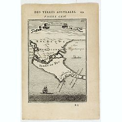
Dt de Magellan.
Interesting map depicting the area around the Magellan's Strait: the south most tip of South America and the Tierra del Fuego island. The map is inserted in a perspective...
Date: Paris, 1683
Selling price: ????
Please login to see price!
Sold in 2015
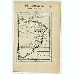
Bresil.
Interesting early map of Brazil. The wild inland as for example the later state of Mato Grosso was still unexplored. The eastern border of Brazil is called Terre Inconnue...
Date: Paris, 1683
Selling price: ????
Please login to see price!
Sold in 2023
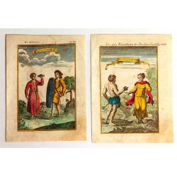
Habitans des Isles de la Sonde & Molusques (2 Prints)
Two fine engravings of the inhabitants of Indonesia. They are from "Geographie, Ancienne & Moderne."
Date: Paris, 1683
Selling price: ????
Please login to see price!
Sold in 2017